Nous arrivons à Irkoust début mars 2020 après 4 jours de Transibéria. Nous allons voyager à deux pendant 7 jours en itinérance, à pied, avant de rejoindre Irkoust. Je souhaiterai, pour les nuits, bivouaquer ou dormir dans des refuges/cabannes,
Certains ont-ils déjà fait ce genre de voyage dans ce coin là et à cette période de l'année? Avez vous des idées d'itinéraire ou d'endroit où dormir?
Je vous remercie d'avance pour vos réponses, et au plaisir de vous lire.
eh vous connaissez le climat en Russie en mars ? Au lac Baïkal il doit faire -20 -30degrés donc c'est pas trop la période pour bivouaquer...
Bonjour,
Oui je me suis renseigné sur le climat en Russie, et en effet il fait froid à cette période, mais certains le font quand même, avec un équipement adapté. Je préférai cependant dormir dans des abris en dure, style refuge ou cabannes, mais j'ai encore peu de connaissance sur la région du lac Baikal, d'où ma discussion.
outre le conseil pour le froid ...peut-être envisager, en cas de bivouac, un élément dissuasif pour éloigner les loups , ours ...😉
en mars, normalement les ours sont encore en hibernation. Les randonneurs russes que j'ai rencontrés n'étaient généralement pas armés, et ils ne m'ont pas parlé de gros risques avec les loups sur le rives du Baïkal, du moins dans le secteur entre Irkoutsk et Olkhon.
Je préférai cependant dormir dans des abris en dure, style refuge ou cabannes, mais j'ai encore peu de connaissance sur la région du lac Baikal, d'où ma discussion.
il y a quelques cabanes, mais aucun refuge gardé. Dans les cabanes ouvertes aux randonneurs, on trouve un poële et de quoi couper du bois. Et à moins que ça ait changé récemment, les sentiers ne sont généralement pas balisés.
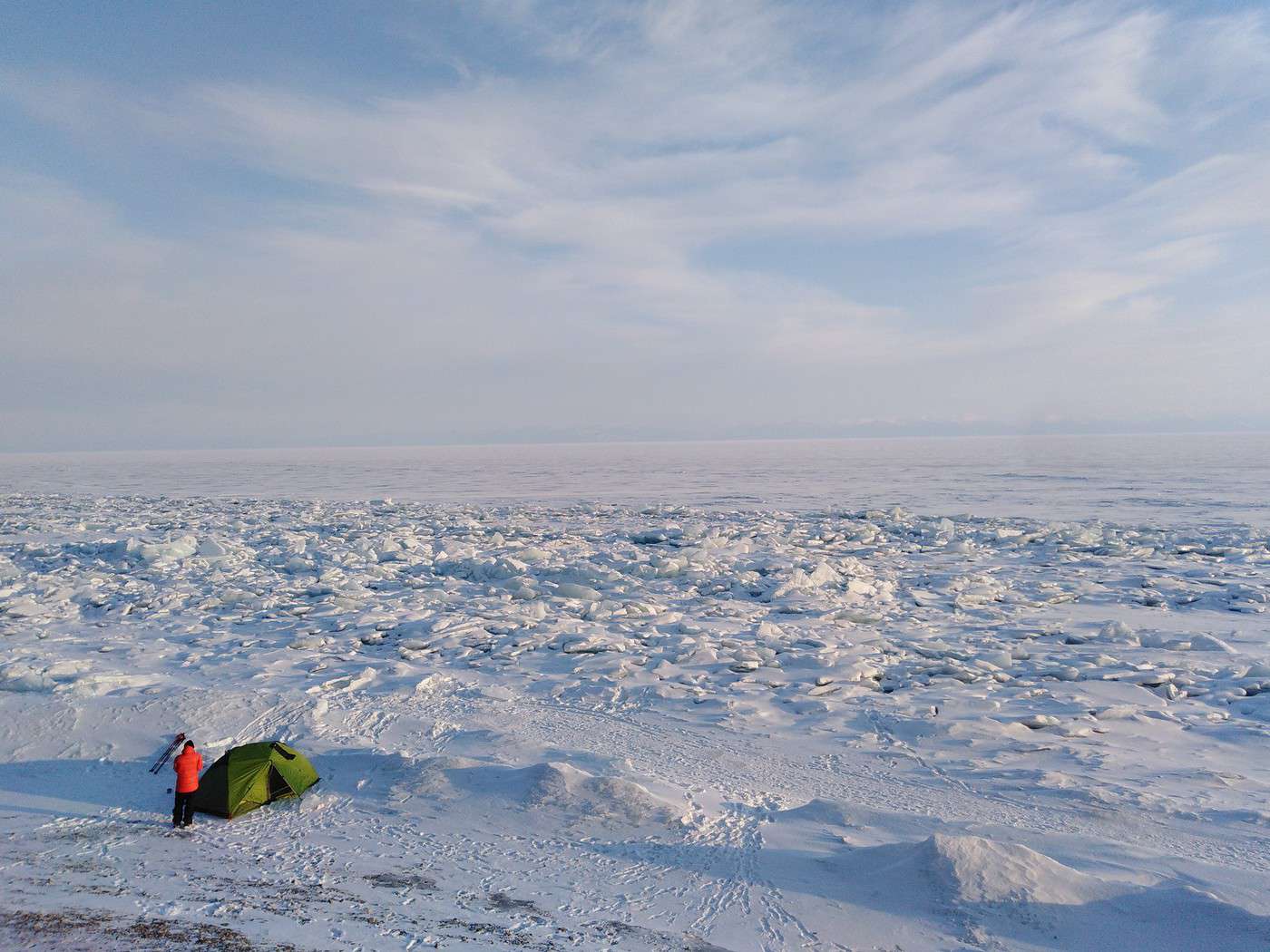
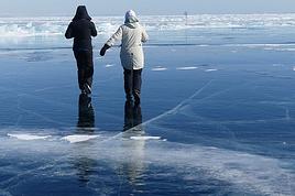
La température peut descendre à -30 début mars, elle s'élève progressivement vers -10°C au fil du mois. Mais attention, il y a souvent du vent sur le lac. Prévoyez des crampons (au moins de petits crampons de marche pour chaussures souples) si vous voulez marcher sur le lac quand le vent souffle. La glace du Baïkal est magnifique début mars.
J'avais fait le tour de l'île d'Olkhon à vélo, sans me presser, puis j'avais rejoint Elantsy avant de retourner en marshrutka à Irkoutsk. C'était très beau, et relativement facile (on peut alterner bivouacs, et nuits en dur dans des villages). Sur le lac, les randonneurs russes sont plutôt en patins, mais il y en a à pied aussi ; je pense que le tour de l'île est faisable à pied en une semaine.
C'était très beau, et relativement facile (on peut alterner bivouacs, et nuits en dur dans des villages). Sur le lac, les randonneurs russes sont plutôt en patins, mais il y en a à pied aussi ; je pense que le tour de l'île est faisable à pied en une semaine.
Bonjour Meg2,
Merci pour votre réponse très intéressante ! Je vais faire des recherches pour trouver des cabannes accessibles et pas trop perdus non plus.
A quelle periode y étiez vous ? Savez vous si l'auto-stop ( camion, voiture, ou autre) est quelque chose qui est courant dans la région ou non ?
Merci, bonne journée à vous.
Arnaud
Oui je me suis renseigné sur le climat en Russie, et en effet il fait froid à cette période, mais certains le font quand même, avec un équipement adapté. Je préférai cependant dormir dans des abris en dure, style refuge ou cabannes
bonjour je conseille vivement de passer quelques jours ne serait-ce que sur les plateaux du Jura ou du Vercors en février par temps froid afin de voir de quoi il en est.
Parce que le froid ce n'est pas fait pour tout le monde
Et le problème c'est que l'hiver ne veut pas venir donc diifficile de trouver des véritables conditions nordiques.
Ensuite oui vient le problème de se ravitailler donc il faut embarquer des rations pour plusieurs jours
Je vais faire des recherches pour trouver des cabannes accessibles et pas trop perdus non plus. A quelle periode y étiez vous ? Savez vous si l'auto-stop ( camion, voiture, ou autre) est quelque chose qui est courant dans la région ou non ?
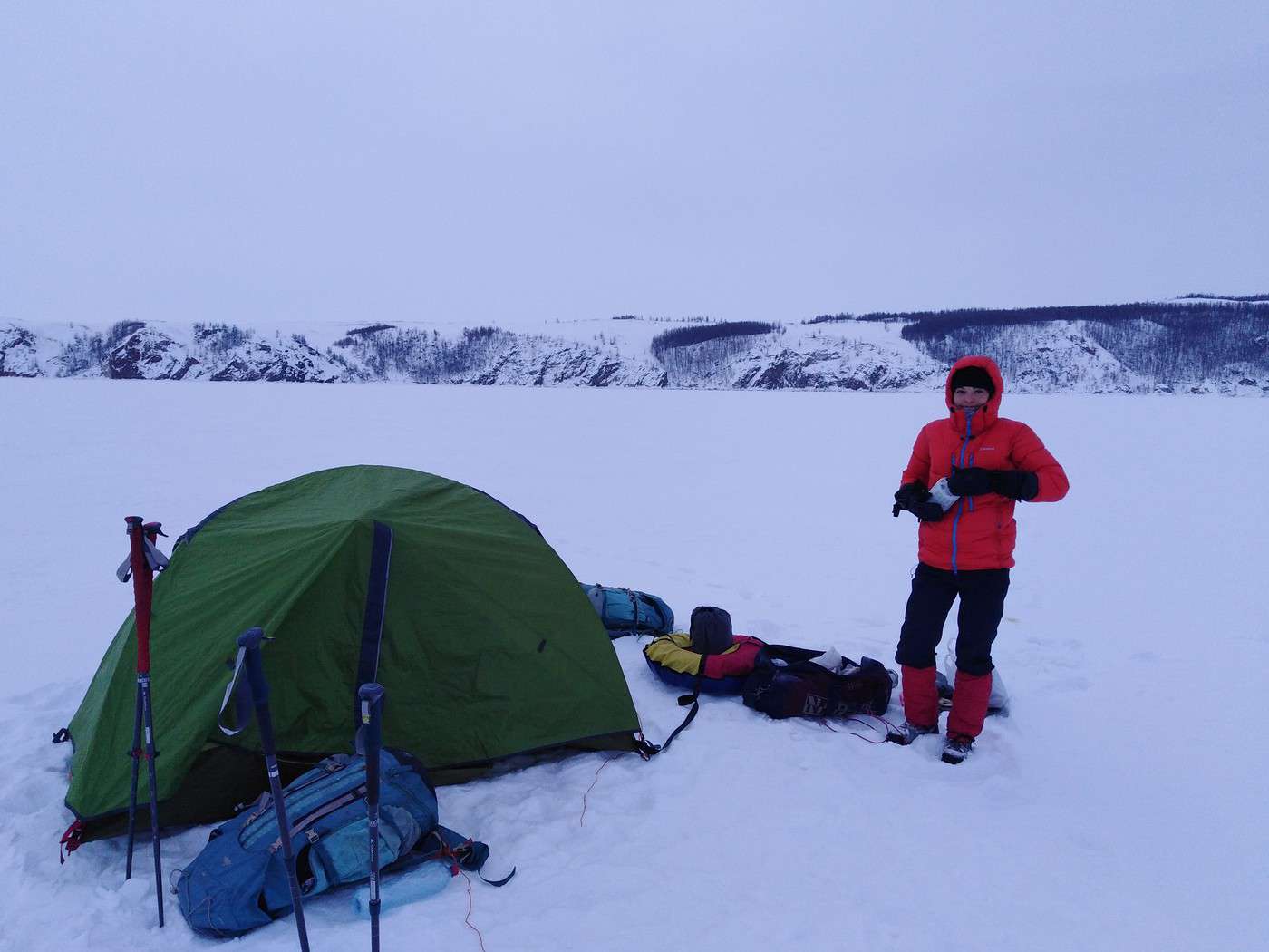
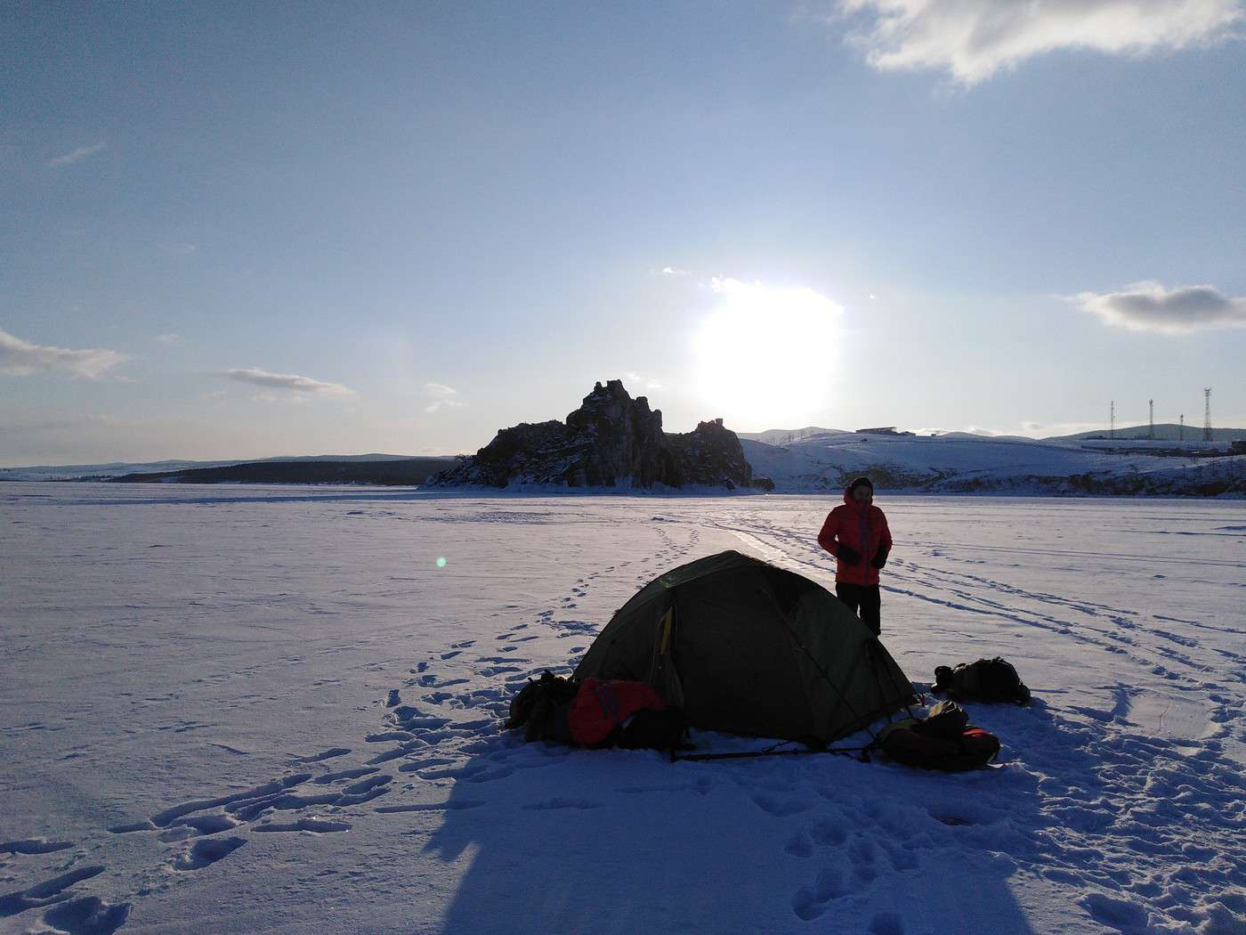
J'étais arrivée à Irkoutsk début mars. C'est une belle période pour randonner sur et autour du Baïkal. Le tour de l'île d'Olkhon, ce n'est pas "loin de tout", c'est bien pour débuter. Il y a 3 villages où vous pourrez trouver tout le nécessaire (ravitaillement et hébergement) : Khuzhir, Sakhyurta, et Uzur (attention, à Uzur il n'y a qu'un seul gîte, pas très grand, parfois complet) ; plus un hameau sans infrastructure mais où des habitants peuvent vous dépanner en cas de nécessité, Peschanya. Entre les villages, j'avais bivouaqué en tente. Il y a aussi 2 ou 3 villages sur la côte entre Listvyanka et l'île d''Olkhon.
Autour de l'île d'Olkhon, vous verrez d'autres randonneurs, quasiment tous russes. Si vous vous écartez sur le continent, ou si vous allez plus au nord le long de la côte, ce sera plus sauvage, et les distances entre points de ravitaillements pourront devenir longues. Les randonneurs russes tractent généralement une pulka, car le volume d'un sac à dos est trop petit pour un raid hivernal en Sibérie si vous vous écartez davantage des zones habitées.
Les Sibériens évitent de faire de l'auto-stop : sur les petites routes transverses il y a peu de passage ; et sur les routes principales, il y a des navettes de minibus ou des taxis partagés. Mais si vous êtes en rade le long d'une route, quelqu'un finira par s'arrêter pour vous dépanner. Simplement, ce quelqu'un, vous risquez parfois de l'attendre longtemps...
Pour plus de détails vous pouvez jeter un coup d'œil à mon blog :
blog.zamir.fr/.../Basses-temperatures
ou
blog.zamir.fr/...16/03/08/C-est-parti
Bonsoir,
J'ai commencé à lire votre voyage, c'est superbe et ça apporte beaucoup de réponses. Je vais potasser tout ça et je reviendrais vers vous czr j'aurais sûrement des questions.
Sur ce passez de bonnes fêtes.
Arnaud
Je suis à la recherche d'un guide local pour le lac Baikal, à des tarifs intéressants, et qui ne dépende pas d'une trop grande agence touristique. Quelqu'un en connait-il un ?
plusieurs petites agences d'Irkoutsk organisent des tours à pied, en raquettes, en patins, à cheval ou autre sur le Baïkal ou dans la région. J'avais rencontré Alexey Golovinov, qui gère sa petite agence Baïkal-Lake à Irkoutsk. Alexey est parfaitement francophone, il a une bonne connaissance du terrain, et m'avait donné quelques conseils pratiques même sans que je fasse appel à lui pour un tour guidé (j'étais autonome à vélo, et en plus, il partait guider un petit groupe en Yakoutie au moment où j'allais me promener sur le Baïkal). Je ne connais pas ses tarifs mais c'est probablement raisonnable, vu qu' il n'y a pas d'intermédiaires.
mon départ approche...je souhaite donc aller passer quelques jours sur l'Ile d'Olkhon, en faisant des petites haltes à Lystvianka, Bolshie Koty, et autres petit villages de la côte Ouest où on peut s'approvisionner. Y a-t-il des transports qui vont quotidiennement de village en village par le lac ? J’imaginais aussi utiliser des transports locaux (en commun ou privé ) pour me déplacer jusqu'à l'Ile, certains ont-ils déjà voyager de cette manière?
les transports en commun privés sont des minibus appelés marshrutkas. Il y en a plusieurs par jour sur les trajets Irkoutsk - Lisvyanka et Irkoutsk - Elantsy - Sakhyurta - Olkhon, ainsi que Irkoutsk - Kultuk - Barguzin - Ulan Ude (ce dernier trajet est faisable aussi en train). La plupart partent du marché central d'Irkoutsk ; il y en a quelques-uns à la gare aussi.
Sur d'autres routes, pas de ligne régulière, ce sera du transport à la demande : taxi partagé ou non selon les opportunités, ou hydroglisseurs / aéroglisseurs sur le lac (plus cher).
Nous voilà bien rentrés de ce superbe voyage, je voulais donc faire un petit récap car un certain nombre de personnes ont participés à cette conversation, et m'ont été d'une grande aide.
Après 4 jours en 3ème classe dans le transibérien, avec des rencontres en tout genre, nous avons pu rejoindre Irkoust, à 70 km du lac Baikal. Nous avons ensuite poursuivi notre voyage par 3 virées en autonomie, de deux à trois jours maximum, avec des bivouacs sur la glace, parfois éloignés des côtes. Dans un premier temps vers Lystvianka, et ensuite sur l'île d'Olkhon ( côte Est, de Sakyurta au cap Koboy). Malgré les nuits assez fraiches (-20), nous n'avons jamais eu froid sous la tente, on était même très bien. Les moments à bien gérer pour ne pas se refroidir sont le soir en s'installant, et au petit matin en pliant bagage. Nous étions bien équipés, mais pas de manière démesuré: sac de couchage, tapis de sol, sac à viande en coton, vêtement thermique. On s'est approvisionner à décathlon pour l'ensemble de ces affaires (Djelma, je pense que tu peux revoir sérieusement tes jugements sur la marque Décathlon!;) On y trouve du matériel de très bonne qualité et abordable, plus précisément les produits "Simon" spécialisés dans l'alpinisme ;) ).
Donc oui on peut bivouaquer à cette période là autour du lac, le tout est d'être un minimum équipé, de respecter certaines techniques de couchage et notamment d'isolation, de se faire conseiller sur place. Mathews, Je suis content de ne pas avoir suivi ton conseil à la lettre , sinon j'aurais fait du camping chez moi à Lyon ;). Et de plus , la glace en travaillant vous offre un réel concert, un peu impressionnant au début, mais vraiment magique.
Bref, un voyage à faire à cette période de l'année, ça en vaut vraiment le coup je pense.
Merci pour vos conseils, et à bientôt pour de nouvelles aventures.
je suis contente que ça vous ait plu , et que vous fassiez partager ce retour d'expérience positif. J'ai moi-même envie d'y retourner un jour, en hiver comme la première fois
Hi,
We’re planning to do the 4-day trek from Mestia to Ushguli without an agency. The descriptions mention that there are accommodations at each stop, but we can’t find any details about them. Has anyone got info or feedback on this route?
We're planning to trek in Peru and Bolivia and would love to find some local agencies.
If you know any, could you share details on prices and, of course, the names of the agencies?
Which trek would you recommend?
Elocine
Je pars en autonomie totale sur un trek au Maroc (10jrs) Imilchil - Aghbalou.
Trouve t-on des cartouches gaz à vis (Coleman, Primus) à Marrakech (adresse) ou villages entre Imilchil - Aghbalou ?
Si non , trouve-t-on des cartouches Butagaz pour camping-gaz (petit volume 230 gr ...)
Merci d' avance pour vos réponses
Hello, I’d like to embark on a little trip in my home country, Switzerland. I’ll start walking from La Cure, heading toward Le Noirmont first, then I’ll improvise my route—but it’ll probably follow the French border... at least as far as Lac de Joux.
I’ll decide day by day how much farther to go after that. My goal is to stay in nature as much as possible, wander around for as long as I can, and restock food in villages or towns along the way.
I’m thinking of mostly camping, but we’ll see if I end up in a hotel or another campsite depending on my route.
I’d love to reach La Chaux-de-Fonds on foot... maybe even Delémont.
The whole thing should take about a week, give or take.
I’ll be bringing my dog, and I’m preparing for this as soon as I’m ready.
Any tips to make sure everything goes smoothly for us? Things I should know—or avoid? What about shepherds with their flocks of sheep? And isn’t hunting season open right now?
I’m not sure if what I’m planning is even doable, which is why I’m asking around.
This’ll be my first time doing something like this—wandering in nature *and* with a dog. I’m really excited for this adventure... and I need it. Thanks!
We’re really keen on ecosystems and want to hike in "natural" ancient forests—not planted woods or areas heavily degraded by human activity. Travel guides (like Lonely Planet) don’t provide much info on this. Could you point us to the most interesting spots?
Thanks in advance for your tips.
We wish you happy holidays and a fantastic 2026, full of discoveries!
Claire and Albert
Hi, this might not be the right section, but I’d like to know if it’s possible to start mountaineering with another person without necessarily hiring a guide. We’ve done quite a bit of hiking but not mountaineering—we’ll just do a half-day glacier course. After that, we were thinking of starting with La Grande Motte and the Pointe de la Traversière, which were recommended to us. Honestly, for things like roping up and knots, I’ll learn at home with lots of videos and a book.
Jaimerais savoir si quelqu'un aurait fait des treks sur le Ruwenzori et combien ça coute en moyenne, les infrastructures, les paysages la sécurité sur les lieux, merci beaucoup. J'attends avec impatience vos réponses.
We’re leaving in 9 days for a two-week trip to Madeira, mainly to hike.
From my research, I’ve found that since last year, access to most trails—and systematically for the most popular ones—is now paid. You have to pay an access fee of 4.50 € per person per classified hike in 2026, and even 10.50 € for the most iconic hike: Pico Arieiro to Pico Ruivo. When paying, you also have to choose a day and a 30-minute time slot for your start time. Of course, this reservation is neither changeable nor refundable, even if the weather that day is terrible.
Personally, given the massive influx of tourists to the island in recent years, I don’t mind paying a fee to help maintain the trails. Similarly, setting a limit on the number of people who can hike them per day is certainly preferable to preserve this priceless heritage.
However, what’s much less fair is that in reality, most of the available spots are reserved: 1/ for Madeira residents (which is normal); 2/ for "economic operators" (meaning local tour operators). For example, if you’re a non-resident (independent tourist), no booking is possible for the Pico Arieiro hike for an early morning start before September! So, unfortunately, we’ll have to skip this hike.
It’s the same issue for Ponta de São Lourenço, the 25 Fontes, Pico Ruivo... in short, all the most popular hikes. Oh well, we’ll skip those too!
So my question is: which hikes do you recommend where we won’t face the huge crowds that the others get? And where we can book the day before for the next day, taking the weather into account?
Finally, a quick accommodation question: we’ve booked the first week in Funchal, but I haven’t decided yet for the second week. Do you have any advice on where to stay in the south or north, preferably avoiding overly concrete-heavy and touristy spots?
I’m reposting about the logistics for Samaria Gorge.
I’d love to get recent info, especially about whether it’s possible to park my car in Omalos, do the hike, and then catch a bus back to my vehicle.
In theory, it’s doable, but when you check the KTEL website, there aren’t any feasible schedules listed. If anyone has recently organized this with reliable, verified details, I’d really appreciate it. Thanks in advance!
Hi there,
We’re flying from Montreal to Lyon this August to go hiking in the French Alps. We’ve rented a car and will be staying at campgrounds. We’re planning to do day hikes and want to stay a few days in one spot, do a few hikes, then move on to our next camping spot. Could you share your favorite spots or any recommendations for places to spend a few days with great hikes?
A few details:
We arrive in early August and leave in early September.
We’re looking for day hikes (or shorter), moderate difficulty, with a cumulative elevation gain of no more than 1000m, and of course, beautiful scenery!
We’d prefer not to drive too much—maybe it’s best not to head too far south and deal with unnecessary heat?
Along the same lines, if you know of any great campgrounds where we can start our hike directly without needing the car, we’d love to hear your suggestions!
Bonjour
Souhaitant faire de la randonnée sur cette île, je voudrais d'abord savoir quelle serait la période la plus favorable sachant que j'avais passé quelques jours en novembre 2018 pas pour cette activité mais plus pour une simple découverte de l'île et le temps n'était pas top notamment en montagne. Donc peut on choisir une organisation en étoile sachant que je louerai un véhicule avec éventuellement 2 points d'hébergement.
Je n'envisage pas d'intégrer une structure mais de partir à 2 et de s'organiser sauf si vous me conseillez une agence locale ou un guide local. Enfin même si je compte me procurer les différents supports, carte et topo guide plus gps je vous remercie de bien vouloir me communiquer les randos à faire en priorité
Merci beaucoup pour vos informations
I’m planning to do the Mercantour crossing following the Randoxygène route in mid-July.
I’m used to hiking in the mountains, but I sometimes get vertigo, for example on ridges with drops on both sides. I wanted to check if there are any T4 or T3-T4 sections and find out if there are any very exposed passages—and if so, where—so I can plan an alternative route.
Can anyone give me some info on this?
Thanks!
I’m planning a trip around Cap Corse and the AGRIATES in 2026, from May 8th to 15th (there are still 2 spots left, by the way! Just DM me if you're interested).
I’d love to know which hikes are worth prioritizing in the AGRIATES. We’ll be staying in SALECCIA for two days as our base—what should we focus on from there?
A round trip to IGNHU beach? Any other suggestions?
For Ostricano, I think it’s too far for a round trip...
Thanks for your tips!
Have a great day,
Anie, Toulouse
I’d like to get some info about the GR10 Pyrenees traverse. I need help planning the daily stages and accommodations—my wife isn’t an experienced hiker but walks a lot, so I’d like to schedule shorter walking days and thus a longer overall trip in terms of number of days.
Could anyone give me some help and advice?
Best regards,
New to this forum, I’m planning a pretty big project for 2028.
I’m heading to Nepal to do a trek from Kathmandu all the way to Everest Base Camp (a cool 5,300 m 😄).
This trek is a bit special because even though I’ll be part of a group, I’m going solo (so far, no problem—I’m used to it). But it’s my first real trek, and it’s also a humanitarian one: once I reach base camp, I’ll stay an extra week to help clean up the waste left by tens of thousands of climbers! Since I’m originally from South America, from two countries that share the Andes, I have a deep respect for mountains—they fascinate me. So Everest… it’s kind of the trip of a lifetime!
So, a little question for those who’ve done treks to Everest before… any tips for good mental preparation (I’m already working on the physical side)?
Hi there, I’m planning the Annapurna Circuit for March 2027 and I’m looking for a local agency with a local guide—preferably French-speaking—to arrange this trek for us. Any suggestions? Thanks
Hello!
We’re spending a few days in Toraja country at the end of May. We’d love to do a day trek—taking our time—on a route that’s stunning in terms of scenery, but not a level 5 in difficulty!
Any suggestions you can share, please?
Thanks in advance
I’d like to do the Mare a Mare Sud in May over 4 days. I’ve found quite a few places to stay along the route, but I’m stuck on the start and finish.
I’ll be arriving by plane on Sunday evening and would like to start pretty early on Monday morning. Ideally, accommodation right at the trailhead (Alzu di Gallina) would be amazing, but I can’t find anything. Any tips?
Also, for the transfer from Figari Airport to Porto Vecchio or Alzu di Gallina?
At the end, I’d like to pick up a rental car—any advice on that too?
I’m traveling solo by plane to Catania in May and plan to hike the northern side of Etna, starting from Linguaglossa where I’ll arrive by bus. After that, I’d love some info on how to get up to Piano Provenzana (shuttles or hitchhiking), since it seems there’s no public transport except in the summer. Can you sleep there in a free or cheap refuge, or camp? And how far up can you go without having to hire a guide? Thanks in advance. Bernard.
Bonjour a tous,
je pars en voyage au Maroc en aout et nous allons commencer par nous arrêter a Chefchaouen(nous sommes en voiture).
Ma question: quelqu'un peut il m'indiquer un itinéraire de rando en boucle d'entre 5 et 7 jours aux départ de Chefchaouen dans le parc de Talassemtane passant si possible par le pont de dieux?Ou un guide papier qui en reunis quelques uns?
Nous privilégions le camping sauvage et les gites.
Merci d'avance
Hi there, for those who’ve been recently—is it possible to find other solo travelers in March on the island to share transport or room costs? It doesn’t seem easy to travel on a budget.
If you have any recommendations for simple lodgings or places with dorms, I’d love to hear them.
For those who’ve done multi-day treks while moving around: do you need to bring your own sleeping bag? I’d love to hear about itineraries you’ve done without a guide, just with a map and GPS.
Thanks, and have a great day!
Hi everyone!
We’re planning a 15-day road trip to Scotland this summer, specifically to explore and hike on Lewis and Harris—places we’ve never been before. We’ve visited other islands on previous road trips in Scotland (we usually go in April for a week). This would be our first time in Scotland in the summer and for 15 days. We’re looking at late August to early September.
I’m currently drafting the itinerary. We’d be crossing from Ullapool and were thinking of spending 3 nights on Harris and 4 nights on Lewis.
Does that sound balanced to you? Is it better to keep the same accommodation on Harris and the same on Lewis to explore the area? I’d love to hear about any past experiences you’ve had on these islands.
Thanks!
Hi there, I’m trying to leave for 15 days very soon to São Vicente. I’m either looking to join an agency or figure things out on my own to go hiking on one of these islands or both. From what I’ve seen, it’s not easy to organize with local transport, so it gets expensive. Can I use the services of a small local agency? I’m looking for the simplest way to hike for several days. Also, how do you get from São Vicente to São Nicolau? Thanks in advance and have a great day!
Aichatou
I’ve been wanting to do this for several years, and this year’s the one. Next September, I’ll be trekking in Tusheti (Georgia), from Omalo to Shatili.
Of course, I won’t be renting a vehicle that’d just sit unused. No problem getting to Pshaveli, but from there to Omalo, it’s a dirt road (still the case?)
There must be some form of public transport since there are so many guesthouses, and not all travelers come in a 4x4.
If any of you have been to Omalo, could you confirm that these shared transports exist and how often they run?
we’re planning a trip to Yellowstone and hoping to do a three-day backcountry hike if we get a permit.
if any of you have done this before, could you let me know if it’s possible to find water along the way? And if we can transport it, are we allowed to use a stove?
Hello,
I’ll be in Nepal from March 6th to 29th (we’re flying into Kathmandu via Varanasi and leaving via Delhi).
I’m a bit confused about the regulations requiring a guide.
My wife and I (we’re 63 and 64) aren’t experienced trekkers—we’re more used to walking on terrain with very moderate elevation changes. I’m looking for fairly easy hikes, possibly day trips.
Here are my questions:
- Does the Poon Hill trek from Pokhara require a guide, or is it better to go through a local agency? (I’ve seen a lot of them offering 4-day packages)
- I’d like to do a few multi-day hikes around Jomsom (Kagbeni, Mukitinath, Lupra, Marpha)... Do you need a guide for those, and can you find accommodations easily without booking in advance?
Last question—I’m really hesitant to lug around a sleeping bag or down jacket during our 6 weeks in India. Can you easily find these kinds of items at reasonable prices in Pokhara?
Thanks in advance for any tips you can share!
Yann
I’m a 56-year-old man who’s done several treks in Nepal and elsewhere. Also passionate about photography.
I’m looking for one or more people to form a group for a trek in Nepal. The trek is the Annapurna and Manaslu circuit (24 days), including a stop at Tilicho Lake. I’ve got a great itinerary and the local company seems solid. The price is around $1600.
I’ll be in Nepal from April 5 to May 12, 2026, so the trek would need to happen within those dates.