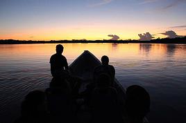
On aimerait bien essayer (!) d'atteindre le sommet d'un de ces 2 volcans? On est jeunes et plutot sportifs mais sans grande experience de la montagne. Quel sommet recommenderiez vous, question beaute des paysages mais aussi difficulte. Pour Cotopaxi, on se fait un peu de souci avec le mal de l'altitude. On atterit a Quito, on va passer 2 jours a Quito et 2 jours a Latacunga pour s'acclimater. Jouable? Sinon on envisageait El Misti car on aura plus eu le temps de s'acclimater. D'ailleurs question bete, quand on redescend au niveau de la mer (genre Lima), est ce qu'il faut du temps apres pour se re-acclimater? Merci de vos conseils
Je suis allé au Cotopaxi jusqu'à l'endroit le plus haut où on peut aller en véhicule (et je suis redescendu à vélo), environ 4500 M si mes souvenirs sont bons. D'autre part je suis allé au pied du Misti mais je ne suis pas grimpé. J'ai été aussi régulièrement à 5000 M ou un peu plus(Chimborazo, Bolivie) mais quand je n'étais pas acclimaté d'une dizaine de jours, ce n'était pas évident; j'ai 50 ans mais je suis en bonne forme physique, je fais régulièrement du sport.
C'est pour cela que j'ai des doutes sur les quatre ou cinq jours d'acclimatation, cela me semble peu.
D'autre part, d'après mon expérience et de ce que j'en ai discuté là-bas, on perd assez vite l'accoutumance à l'altitude.
Je peux te donner des infos sur le Cotopaxi, J'etais en Equateur en 2001.
Le Coto n'est pas un sommet difficile, mais il demmande comme même un minimun d'expérence de cramponage et de haute montagne.
C'est facile jusq'au niveau de cette barre de rocher caractéristique qu'on voit sous le sommet sur toutes les photos, apres la pente se redresse.
Attention aux conditions meteo vent entre autre, nous avons abandonné d'ailleurs à cause du vent au pied de la pente.
Pour l'aclimatation c'est bien de faire deux 4000 et un 5000 avant. Le volcan au desus de Quito et pas mal. A verifier pour l'acces mais à l'epoque il falait éviter l'acces depuis Quito (le plus court) braquage des touristes et passer par le versant opposé, grosse galère personne ne connaissait ce chemin, que nous avons fini par trouver depuis un terminal de bus à l'autre bout de la ville et encore c'etait un particulier qui nous a conduit avec sa voiture moyennant bien sur un peu d'argent.
Si tu retourne au niveau de la mer tu perds rapidement les bénéfice de l'aclimatation de l'ordre d'à peine 1 semaine je crois.
Le Chimboradzo est aussi un beau sommet.
Attention à Quito un vol ne faire confiance à personne surtout dans les transport en commun ne donner vos affaire à personne sous aucun pretexte mettre soi meme c'est affaire dans le soute du car et rester à cote jusqu'a la fermeture des coffres idem à l'interieur les objet de valeur sur soit pas dans les portes bagages au desus des sièges surtout si on vous le demmande ( vol organisé avec les chauffeurs coroption ). Je me suis fait voler des affaire et vu des scenes de vol. Je te racure c'est juste à Quito
Bon voyages
... Tout dépend de ce que tu veux faire : monter sur un tas de sable géant ou bien sur un glacier. Moi, a votre place, je resterai un poil plus longtemps pour l'acclimatation avant le Cotopaxi (un ou deux jours de plus) et ensuite, bien acclimaté, je grimperai sur le Chachani (acces depuis Arequipa tout aussi simple que le Misti), histoire de revenir avec "un 6000" en poche. C'est pas plus compliqué que le Misti, et bien plus sympa comme balade.
Une fois acclimaté, tu peux redescendre sans probleme quelques jours au niveau de la mer. Au dela de 10 jours tu commence vraiment a perdre tes globules rouges supplémentaires et il faut tout recommencer.
"Old travellers never die, they just smell that way"
Merci pour tes conseils. Tu penses que si on reste qq jours de plus en altitude, peut etre quite a faire un autre sommet, plus facile avant, on pourrait tenter?? Si tu as des suggestions. Je n'ai pas compris la reference au tas de sable? desole. Je vais me renseigner sur la chachani. En quoi c'est different du Cotopaxi? Mon copain etait tres interesse par le Cotopaxi a cause de la neige, il est australien et n'a jamais vu la neige.
Ton copain n'a jamais vu de la neige.
Je te conseil de prendre un guide ( sauf si toi tu as de l experience en montagne) mais attention il y en a des mauvais sans notion d'assurance de cordé ( vu en 2001 peut etre des progres depuis)
Référence au tas de sable : Le Misti est un énorme tas de sable. Son ascension est vraiment fastidieuse. C'est du genre deux pas en avant, un pas en arrière.
Pour le Cotopaxi, prenez impérativement un guide (tout ce qu'il faut à Quito) car progresser sur un glacier ne s'improvise pas, surtout de nuit.
Fais des recherches avec les mots Cotopaxi, Misti et Chachani sur ce site, tu trouveras plein d'infos.
Si vous voulez mettre toutes les chances de votre côté c'est sur que grimper un ou deux sommets au préalable, c'est beaucoup mieux.
"Old travellers never die, they just smell that way"
On ne comptait pas partir sans guide. D'ailleurs si qqn a une agende/guide a recommender depuis latacunga on est preneur. Je pense qu'on va faire le volcan pichincha au nord de quito d'abord pour s'acclimater. Besoin d'un guide? puis voir comment on se sent. si on a la peche on tente le cotopaxi. de toute facon meme a mi-chemin la vue est parait-il magnifique. sinon on ira se balader dans le parc national, quite a redescendre en velo comme conseille. Je dois encore me renseigner sur le volcan pres d'arequipa.
Le Pichincha est un sommet tres joli et facile c'est de la rando, ce volcan est actif, nous avons vu en 2001 quelques vapeurs s'échapper du sol.
Par contre c'est bien ce volcan que j'évoquais dans mon post precedent. J'ai ressorti mon topo " LES ANDES guide d'alpiniste de John Biggar au éditions NEVICATA d' octobre 2000" C'est bien là qu'il faut faire attention, je site : L'acces de Quito au RUCU PICHINCHA est déconseillé depuis plusieurs années en raison des vols...."
Acces: se rendre au village de Lloa (TP) ""terminal terrestre"" prendre la Calla Pichincha, passé devant l'hacienda Conception de Monjas et continuer jusqu'au refuge........etc..... Bon courage personne à l'époque ne connaissait.
Conseil d'un super sommet facile et tres beau ILLINIZA NORTE 5105m avec nuit au refuge par contre un 4X4 est une bonne solution pour faire l'approche à louer à Quito.
Je me repete si vous n'avez pas d'expérience de ht montagne prenez un guide à LATACUNGA, je n'est pas d'adresse à conseiller.
Pour exemple ce type d'ascension équivaut à un Mt Blanc.
Si tu veux plus d'infos n'hesite pas.
J'oubliais, , à Quito si ça existe toujours, allez prendre un petit dejeuner au café Colibri, extra, si mes souvenir sont bon c'est un allemand qui tient ce petit café. Tu commence la journée avec un repas gargantuèsque, que du bon.
L'adresse: Joaquin Pinto 619 y Luis Cordero dans le Quito moderne.
Salut, Cotopaxi, c'est dur, tres dur pour le jambes. Shimborazo l'est encore plus, je ne te le conseille pas. Le coto c une expérience super, moi GT acclimaté, j'ai du pourtant faire demi tour vers 5300 - 5400 metre car j'avais plus de muscles... Mais je te le conseille fortement. Guide Obligatoire, c impossible sans. Attention, j'ai commandé un guide dans une ruelle de Quito, pourtant tres pres de l'avenue principale et quand je suis revenu à Quito, l'agence avait fermée !!!! et ils me devaient 150$ alors prend une agence bien en vue.
Par contre tu peux te rendre jusqu'au refuge sans guide, attention à la marche.
N'importe quoi, ca veux dire quoi je te ne le conseille pas !!!!!!! Impossible sans guide !!!!!! si toi ta condition est mauvaise c'est pas le cas de tout le monde.
Je reve il y en a qui ferait mieux de se taire.😠
une bonne acclimatation une bonne condition physique et c'est tout bon.🙂 on peut toujours avoir un coup de pompe😕
Apres suivant son expérience de la montagne on le fait avec ou sans guide.😉
Aucun chemin, glacier tout du long avec des crevaces de plus de 20 mètres de profondeur... je ne me permettrai pas de mettre la vie de QQu en danger en disant qu'il ne faut pas de guide car il faut connaitre le chemin par coeur. Si vous etes un expert et avez grimpé le cotopaxi a maintes reprises je vous comprend mais ce n'est pas le cas de 99, 9% des gens. Ceci dit pour l'effort j'admet ne pas un grand sportif, néamoins c'est du 40% tout du long, avoir donc de très bonnes jambes et oui une exellente acclimatation si vous ne voulez pas vous faire de faux espoirs de voir le sommet.
Je dis bien SUIVANT SON EXPERIENCE en montagne, on le fait AVEC OU SANS GUIDE.
ce qui me rend furieux se sont les avis et les affirmations cathégoriques. On doit donner son avis en rapport à son expérience.
Personnellement j'ai fais ces sommets sans guide, ce n'est pas pour autant que je dis allez y sans guide, j'ai une bonne connaissance de la montagne, et je deconseille à ceux qui n'en on pas de le faire.
Sans rancune jeandavid.
Okay babay, la je suis daccord. Bref, peu importe que tu prennes un guide ou pas tu n'en reviendra pas de la beauté du paysage, même pendant l'assention si la visibilité est correcte la vue est spectaculaire.
Je part vers l'équateur le 9 janvier et je n'ai évidemment aucun plan précis de voyage.. Je suis encore et toujours à la recherche de projets ou d'aventures…
J'ai l'intention de partir en mai 2010 en Equateur pour faire l'ascension du Cotopaxi. je ne sais pas si la saison est bien choisie, si vous pouvez m'aider...…
Petite question rapide sur le Cotopaxi: J'aurai voulu savoir si il etait facile de trouver des guides pour monter au sommet du Cotopaxi un fois dans le parc…
Je suis actuellement a Quito avec mon amie, et nous aimerions faire un petit treck au Cotopaxie. Y a pas mal de chose de Quito mais cela coute assez chere.…
Nous dispposons de 5ou 6 jours à Quito. Nous sommes bons marcheurs (GR 2O, Tour du Cervin, Tour des Annapurnas...). Nous aimerions faire un trek dans la région…
Hi,
We’re planning to do the 4-day trek from Mestia to Ushguli without an agency. The descriptions mention that there are accommodations at each stop, but we can’t find any details about them. Has anyone got info or feedback on this route?
We're planning to trek in Peru and Bolivia and would love to find some local agencies.
If you know any, could you share details on prices and, of course, the names of the agencies?
Which trek would you recommend?
Elocine
Je pars en autonomie totale sur un trek au Maroc (10jrs) Imilchil - Aghbalou.
Trouve t-on des cartouches gaz à vis (Coleman, Primus) à Marrakech (adresse) ou villages entre Imilchil - Aghbalou ?
Si non , trouve-t-on des cartouches Butagaz pour camping-gaz (petit volume 230 gr ...)
Merci d' avance pour vos réponses
Hello, I’d like to embark on a little trip in my home country, Switzerland. I’ll start walking from La Cure, heading toward Le Noirmont first, then I’ll improvise my route—but it’ll probably follow the French border... at least as far as Lac de Joux.
I’ll decide day by day how much farther to go after that. My goal is to stay in nature as much as possible, wander around for as long as I can, and restock food in villages or towns along the way.
I’m thinking of mostly camping, but we’ll see if I end up in a hotel or another campsite depending on my route.
I’d love to reach La Chaux-de-Fonds on foot... maybe even Delémont.
The whole thing should take about a week, give or take.
I’ll be bringing my dog, and I’m preparing for this as soon as I’m ready.
Any tips to make sure everything goes smoothly for us? Things I should know—or avoid? What about shepherds with their flocks of sheep? And isn’t hunting season open right now?
I’m not sure if what I’m planning is even doable, which is why I’m asking around.
This’ll be my first time doing something like this—wandering in nature *and* with a dog. I’m really excited for this adventure... and I need it. Thanks!
We’re really keen on ecosystems and want to hike in "natural" ancient forests—not planted woods or areas heavily degraded by human activity. Travel guides (like Lonely Planet) don’t provide much info on this. Could you point us to the most interesting spots?
Thanks in advance for your tips.
We wish you happy holidays and a fantastic 2026, full of discoveries!
Claire and Albert
Hi, this might not be the right section, but I’d like to know if it’s possible to start mountaineering with another person without necessarily hiring a guide. We’ve done quite a bit of hiking but not mountaineering—we’ll just do a half-day glacier course. After that, we were thinking of starting with La Grande Motte and the Pointe de la Traversière, which were recommended to us. Honestly, for things like roping up and knots, I’ll learn at home with lots of videos and a book.
Hi,
I don’t know Switzerland at all and was wondering if Vallée des Joux and especially Dent de Vaulion are packed early in the morning or late in the afternoon in July and September?
If so, do you have any quieter spots to recommend in the area, or in Luxembourg (yes, I know it’s not the same country 😉)?
Thanks a lot!
Jaimerais savoir si quelqu'un aurait fait des treks sur le Ruwenzori et combien ça coute en moyenne, les infrastructures, les paysages la sécurité sur les lieux, merci beaucoup. J'attends avec impatience vos réponses.
We’re leaving in 9 days for a two-week trip to Madeira, mainly to hike.
From my research, I’ve found that since last year, access to most trails—and systematically for the most popular ones—is now paid. You have to pay an access fee of 4.50 € per person per classified hike in 2026, and even 10.50 € for the most iconic hike: Pico Arieiro to Pico Ruivo. When paying, you also have to choose a day and a 30-minute time slot for your start time. Of course, this reservation is neither changeable nor refundable, even if the weather that day is terrible.
Personally, given the massive influx of tourists to the island in recent years, I don’t mind paying a fee to help maintain the trails. Similarly, setting a limit on the number of people who can hike them per day is certainly preferable to preserve this priceless heritage.
However, what’s much less fair is that in reality, most of the available spots are reserved: 1/ for Madeira residents (which is normal); 2/ for "economic operators" (meaning local tour operators). For example, if you’re a non-resident (independent tourist), no booking is possible for the Pico Arieiro hike for an early morning start before September! So, unfortunately, we’ll have to skip this hike.
It’s the same issue for Ponta de São Lourenço, the 25 Fontes, Pico Ruivo... in short, all the most popular hikes. Oh well, we’ll skip those too!
So my question is: which hikes do you recommend where we won’t face the huge crowds that the others get? And where we can book the day before for the next day, taking the weather into account?
Finally, a quick accommodation question: we’ve booked the first week in Funchal, but I haven’t decided yet for the second week. Do you have any advice on where to stay in the south or north, preferably avoiding overly concrete-heavy and touristy spots?
I’m reposting about the logistics for Samaria Gorge.
I’d love to get recent info, especially about whether it’s possible to park my car in Omalos, do the hike, and then catch a bus back to my vehicle.
In theory, it’s doable, but when you check the KTEL website, there aren’t any feasible schedules listed. If anyone has recently organized this with reliable, verified details, I’d really appreciate it. Thanks in advance!
Hi there,
We’re flying from Montreal to Lyon this August to go hiking in the French Alps. We’ve rented a car and will be staying at campgrounds. We’re planning to do day hikes and want to stay a few days in one spot, do a few hikes, then move on to our next camping spot. Could you share your favorite spots or any recommendations for places to spend a few days with great hikes?
A few details:
We arrive in early August and leave in early September.
We’re looking for day hikes (or shorter), moderate difficulty, with a cumulative elevation gain of no more than 1000m, and of course, beautiful scenery!
We’d prefer not to drive too much—maybe it’s best not to head too far south and deal with unnecessary heat?
Along the same lines, if you know of any great campgrounds where we can start our hike directly without needing the car, we’d love to hear your suggestions!
Bonjour
Souhaitant faire de la randonnée sur cette île, je voudrais d'abord savoir quelle serait la période la plus favorable sachant que j'avais passé quelques jours en novembre 2018 pas pour cette activité mais plus pour une simple découverte de l'île et le temps n'était pas top notamment en montagne. Donc peut on choisir une organisation en étoile sachant que je louerai un véhicule avec éventuellement 2 points d'hébergement.
Je n'envisage pas d'intégrer une structure mais de partir à 2 et de s'organiser sauf si vous me conseillez une agence locale ou un guide local. Enfin même si je compte me procurer les différents supports, carte et topo guide plus gps je vous remercie de bien vouloir me communiquer les randos à faire en priorité
Merci beaucoup pour vos informations
I’m planning to do the Mercantour crossing following the Randoxygène route in mid-July.
I’m used to hiking in the mountains, but I sometimes get vertigo, for example on ridges with drops on both sides. I wanted to check if there are any T4 or T3-T4 sections and find out if there are any very exposed passages—and if so, where—so I can plan an alternative route.
Can anyone give me some info on this?
Thanks!
I’m planning a trip around Cap Corse and the AGRIATES in 2026, from May 8th to 15th (there are still 2 spots left, by the way! Just DM me if you're interested).
I’d love to know which hikes are worth prioritizing in the AGRIATES. We’ll be staying in SALECCIA for two days as our base—what should we focus on from there?
A round trip to IGNHU beach? Any other suggestions?
For Ostricano, I think it’s too far for a round trip...
Thanks for your tips!
Have a great day,
Anie, Toulouse
I’d like to get some info about the GR10 Pyrenees traverse. I need help planning the daily stages and accommodations—my wife isn’t an experienced hiker but walks a lot, so I’d like to schedule shorter walking days and thus a longer overall trip in terms of number of days.
Could anyone give me some help and advice?
Best regards,
New to this forum, I’m planning a pretty big project for 2028.
I’m heading to Nepal to do a trek from Kathmandu all the way to Everest Base Camp (a cool 5,300 m 😄).
This trek is a bit special because even though I’ll be part of a group, I’m going solo (so far, no problem—I’m used to it). But it’s my first real trek, and it’s also a humanitarian one: once I reach base camp, I’ll stay an extra week to help clean up the waste left by tens of thousands of climbers! Since I’m originally from South America, from two countries that share the Andes, I have a deep respect for mountains—they fascinate me. So Everest… it’s kind of the trip of a lifetime!
So, a little question for those who’ve done treks to Everest before… any tips for good mental preparation (I’m already working on the physical side)?
Hi there, I’m planning the Annapurna Circuit for March 2027 and I’m looking for a local agency with a local guide—preferably French-speaking—to arrange this trek for us. Any suggestions? Thanks
Hello!
We’re spending a few days in Toraja country at the end of May. We’d love to do a day trek—taking our time—on a route that’s stunning in terms of scenery, but not a level 5 in difficulty!
Any suggestions you can share, please?
Thanks in advance
I’d like to do the Mare a Mare Sud in May over 4 days. I’ve found quite a few places to stay along the route, but I’m stuck on the start and finish.
I’ll be arriving by plane on Sunday evening and would like to start pretty early on Monday morning. Ideally, accommodation right at the trailhead (Alzu di Gallina) would be amazing, but I can’t find anything. Any tips?
Also, for the transfer from Figari Airport to Porto Vecchio or Alzu di Gallina?
At the end, I’d like to pick up a rental car—any advice on that too?
I’m traveling solo by plane to Catania in May and plan to hike the northern side of Etna, starting from Linguaglossa where I’ll arrive by bus. After that, I’d love some info on how to get up to Piano Provenzana (shuttles or hitchhiking), since it seems there’s no public transport except in the summer. Can you sleep there in a free or cheap refuge, or camp? And how far up can you go without having to hire a guide? Thanks in advance. Bernard.
Bonjour a tous,
je pars en voyage au Maroc en aout et nous allons commencer par nous arrêter a Chefchaouen(nous sommes en voiture).
Ma question: quelqu'un peut il m'indiquer un itinéraire de rando en boucle d'entre 5 et 7 jours aux départ de Chefchaouen dans le parc de Talassemtane passant si possible par le pont de dieux?Ou un guide papier qui en reunis quelques uns?
Nous privilégions le camping sauvage et les gites.
Merci d'avance
Hi there, for those who’ve been recently—is it possible to find other solo travelers in March on the island to share transport or room costs? It doesn’t seem easy to travel on a budget.
If you have any recommendations for simple lodgings or places with dorms, I’d love to hear them.
For those who’ve done multi-day treks while moving around: do you need to bring your own sleeping bag? I’d love to hear about itineraries you’ve done without a guide, just with a map and GPS.
Thanks, and have a great day!
Hi everyone!
We’re planning a 15-day road trip to Scotland this summer, specifically to explore and hike on Lewis and Harris—places we’ve never been before. We’ve visited other islands on previous road trips in Scotland (we usually go in April for a week). This would be our first time in Scotland in the summer and for 15 days. We’re looking at late August to early September.
I’m currently drafting the itinerary. We’d be crossing from Ullapool and were thinking of spending 3 nights on Harris and 4 nights on Lewis.
Does that sound balanced to you? Is it better to keep the same accommodation on Harris and the same on Lewis to explore the area? I’d love to hear about any past experiences you’ve had on these islands.
Thanks!
Hi there, I’m trying to leave for 15 days very soon to São Vicente. I’m either looking to join an agency or figure things out on my own to go hiking on one of these islands or both. From what I’ve seen, it’s not easy to organize with local transport, so it gets expensive. Can I use the services of a small local agency? I’m looking for the simplest way to hike for several days. Also, how do you get from São Vicente to São Nicolau? Thanks in advance and have a great day!
Aichatou
I’ve been wanting to do this for several years, and this year’s the one. Next September, I’ll be trekking in Tusheti (Georgia), from Omalo to Shatili.
Of course, I won’t be renting a vehicle that’d just sit unused. No problem getting to Pshaveli, but from there to Omalo, it’s a dirt road (still the case?)
There must be some form of public transport since there are so many guesthouses, and not all travelers come in a 4x4.
If any of you have been to Omalo, could you confirm that these shared transports exist and how often they run?
we’re planning a trip to Yellowstone and hoping to do a three-day backcountry hike if we get a permit.
if any of you have done this before, could you let me know if it’s possible to find water along the way? And if we can transport it, are we allowed to use a stove?
Hello,
I’ll be in Nepal from March 6th to 29th (we’re flying into Kathmandu via Varanasi and leaving via Delhi).
I’m a bit confused about the regulations requiring a guide.
My wife and I (we’re 63 and 64) aren’t experienced trekkers—we’re more used to walking on terrain with very moderate elevation changes. I’m looking for fairly easy hikes, possibly day trips.
Here are my questions:
- Does the Poon Hill trek from Pokhara require a guide, or is it better to go through a local agency? (I’ve seen a lot of them offering 4-day packages)
- I’d like to do a few multi-day hikes around Jomsom (Kagbeni, Mukitinath, Lupra, Marpha)... Do you need a guide for those, and can you find accommodations easily without booking in advance?
Last question—I’m really hesitant to lug around a sleeping bag or down jacket during our 6 weeks in India. Can you easily find these kinds of items at reasonable prices in Pokhara?
Thanks in advance for any tips you can share!
Yann