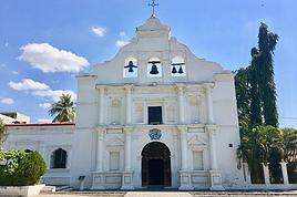
Bonjour à tous, je suis néophyte sur le site et je ne sais pas comment j'ai pu m'en passer avant. Je planifie un voyage au Guatemala(Antigua pour la majorité du temps) du 16 mars au 15 avril, ensuite je descendrai vers la côte Caraibe du Honduras pour aller plonger près des Iles(Roatan ou Utila). J'aimerais avoir des impressions quand à l'ascension des volcans autour d'Antigua(Agua, Fuego et Acatenango).On m'a déconseillé d'y aller seul mais comme je voyage seul... Est-ce vraiment dangereux? Que devrais-je savoir avant de m'y aventurer? Gros merci.😉
Sam
La destination importe peu, le trajet vous transforme.
Iop iop!
Je ne sais pas trop si c'est dangereux (en soi, c'est pas dangereux du tout un volcan...) mais je compte traîner sur les volcans nicaraguaiens quelques semaines autour de mai-juin. Donc si t'es prêt à inverser honduras et guatemala, on peut faire ça ensemble...
Ciao
Salut Gipsy, suis pas certain d'être encore là après la mi-mai mais si ça adonne... J'ai un engagement de la mi-mars à la mi-avril à Antigua(Guate) mais sinon on garde contact. Je me suis mieux renseigné pour ce qui est de "trainer" sur les volcans et ma question se portait plutôt sur les gerrieros et les bolandos. Je peux maintenant t'affirmer qu'il vaut mieux ne pas être seul n'importe ou n'importe quand...Je sais que le Fuego est tjrs en activité donc ça va trouer l'cul!!!! Je ne contient plus ma hâte... À + cousin😎
La destination importe peu, le trajet vous transforme.
je te conseil l'ascension du volcan Tajamulco pres de Xela, 4010m, point culminant de l'amerique centrale quand meme. Et puis le volcan Santa Maria, 3900m, juste a coté. La vue de ces deux volcan est extraordinaire!!! Particulierement le santa maria pour le levé de soleil (faut partir vers 1h du mat), sans doute le plus beau que j'ai jamais vu. Tu vois le pacifique, une cheminée volcanique encore active!, les highlands, le mexique et la chaine toute droite des volcans (ceux d'atitlan semblent a 1 km). Tu te sens haut!
C'est un peu loin d'antigua mais ca vaut le detour.
Escalader la nuit?!? Faut être un peu timbré pour ça, non? Ça m'a l'air d'un bon plan.😕 Est-ce que tu grimpais seul ou avec un guide de Quetzaltrekkers? C'est pas si loin d'Antigua à vrai dire, 150 km le Santa Maria je crois.. Ça devrait bien se faire. Merci du conseil, c'est tentant.
La destination importe peu, le trajet vous transforme.
beh non faut pas etre timbré pour faire des ascensions de nuit. Ca se passe tres bien, ca vaut le coup pour le levé de soleil et puis moi toutes mes ascensions elles ont tjr debuté vers 1-2h du mat.
Pour le Santa Maria j'ai fait appel a un guide (pas des quetzaltrekeurs) et pour le tajamulco j'ai demandé des infos a un guide des quetzal et je l'ai fait avec une amie.
C'est certain que le levé de là-haut doit être inimaginable, je ne peux pas manquer ça.Et pour la visibilité, avais-tu besoin de lampes ou la lune est suffisante?Sur une échelle de 1 à 10, tu dirais quoi pour la difficulté des sentiers? Est-ce à pic? Ce sera une première expérience volcanique pour moi donc, tes réponses et conseilles sont très appréciés.J'ai frappé des pentes extrêmement à pic dans les rocheuses ou il aurait été impossible d'escalader la nuit. Mais si tu me dis que ça se fait...let's go!!😏
La destination importe peu, le trajet vous transforme.
tu prends tjr une lampe quand tu pars en rando un point c'est tt. Et puis c'est boisé jusqu'a la cime presque donc la lune ne suffit pas. Quand au sentier je dirais un 6/10 voire 7. C'est un petit sentier de terre un peu boueux des fois. C'est pentu mais sans plus, j'ai fait pire dans les vosges tu vois. Bon il te faut qd meme de bonne cuisse.
Je t'enverai bien des photos mais j'ai des petits problemes de disque durs. Je vais essayer tt de meme, tu vas aimer. 😉
Wow!Merci beaucoup. Ce site est très complet. Je me sens prêt pour la grimpette. Je dois me mettre en forme car j'ai subi une anesthésie générale il y a 3 semaines.Mais je pense pas que ça pose problème. J'irai à mon rythme. Ma seule crainte étant de ne plus vouloir rentrer chez moi après... C'est généreux de ta part de partager ton savoir.Merci encore et bonne chance avec tes disques.😉
La destination importe peu, le trajet vous transforme.
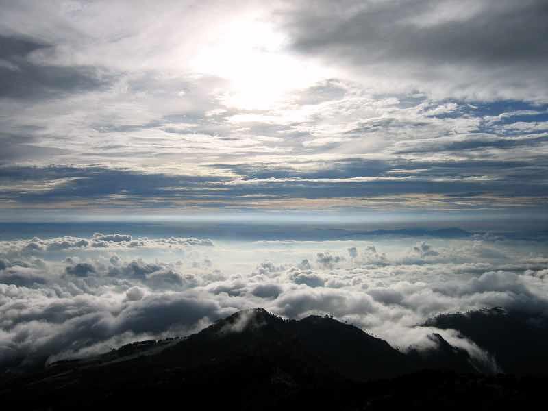
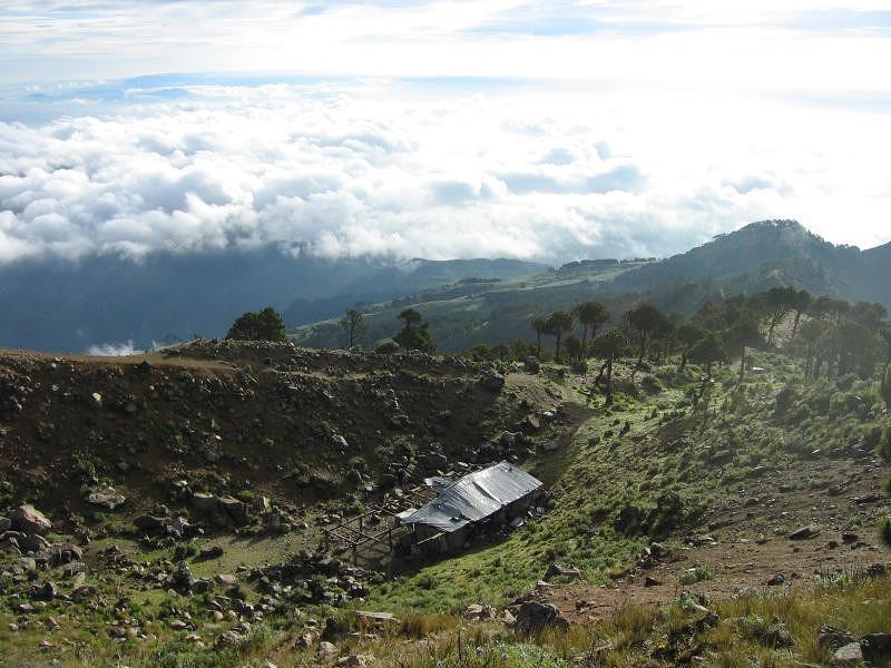
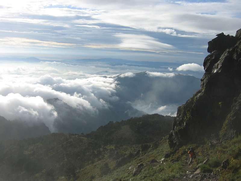
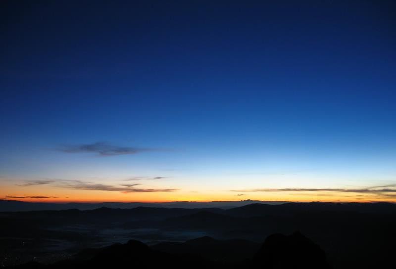
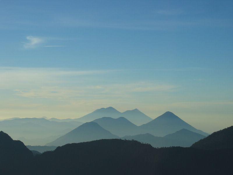
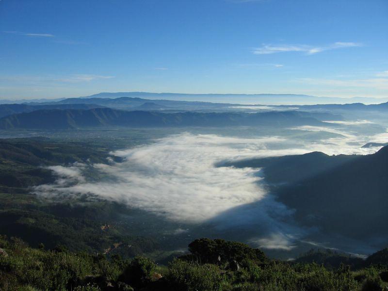
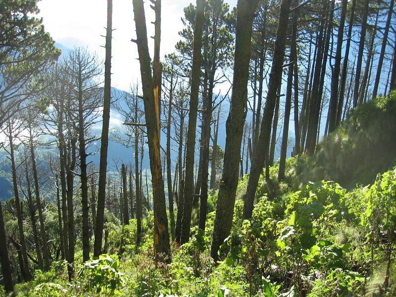
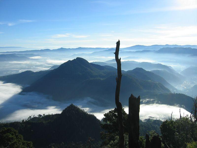
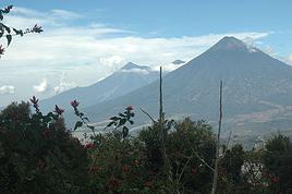
voila qcqs photos du haut des volcans guatemalteques!
Tajamulco, 4220m, gros tas de cailloux et point culminant de l'ame centrale et Santa Maria, 3900m, cone parfait, juste a coté ou presque!
Woahhh p'tain! Tu me mets l'eau à la bouche là. Magnifique les photos. Merci, vraiment, pour cet avant-goût. Ça va être grandiose. Je pars après-demain, ce sera tout un voyage. J'aurai une pensée pour mes potes du VF quand je serai au sommet...
Salut Mat😉
La destination importe peu, le trajet vous transforme.
bonjour,
Actuellement en voyage solitaire au Guatemala, je voudrais savoir quels sont les meilleurs plans pour trouver des bons guides sur Xela pour le Tajumulco, j'ai entendu parler des quetzaltrekeurs ou quelque chose comme cela sur Xela.
Actuellement sur Antigua je suis particulierement decu des prestations offertes par les agences qui ne propose rien sur les volcans a part pour le Pacaya et sont incapables de donner des infos quant aux lieux sur lesquels se rendre pour s'informer.
Je prefere prendre un guide, par inexperience notamment, et car cela me parait beaucoup plus interessant, quite a mettre la main a la poche
Je pourrais donner mes impressions plus tard sur ce que j'aurais fait concernant les volcans guatemalteques.
Je vous remercie d'avance pour les reponses
Tout a fait d accord avec toi concernant Antigua et leur non-information sur les autres volcans.
Du coup je me tourne vers toi pour savoir ce que tu as fait et de quelle maniere. Pour info je souhaitais faire l Acatenango, mais le Tajamulco a l air splendide aussi, alors a voir.
J'ai d'abord fait le volcan de Agua, rien d'extraordinaire au fait, à part le fait qu'il y ait près de 1800m de dénivelé et puis l'altitude. Je l'ai fait tout seul avec un guide et je n'ai eu aucun problème, on se sent en sécurité, il y a très peu de monde à faire l'ascension. J'ai été malade à la fin de l'ascension jusqu'au milieu de la descente, sans doute l'altitude. Si je me souviens bien l'agence par laquelle je suis passé s'appelle "Maya tours" ou quelque chose comme ça, situé à 2 cuadras à l'ouest de la place principale approximativement.
J'ai fait le Pacaya sinon, très touristique, juste pour voir de la lave si il y en a, personnellement, je n'ai vu que quelques point rouge, suffisant pour faire griller des chamalows. Vu le faible coût, le paysage (de la lave noire au milieu d'une prairie) et l'ambiance généré par les guides, je te conseille de le voir quand même, qu'il y ait eu des coulées récentes ou non.
Il est vrai qu'à Antigua, réussir à faire avec une agence un volcan autre que la balade du Pacaya est le fruit d'un coup de bol ou de l'obstination voire des deux
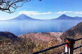
A Atitlan, je n'ai fait aucun volcans, le San Pedro est très populaire mais il y a un point de vue qui s'appelle "la Nariz" à environ 2500m d'altitude soit 1000m au dessus du lac qui permet d'avoir une vue remarquable déjà, pour ces deux choses l'information est très accessible. Au passage, il y a moyen de faire du parapente près de ce point, à San Marcos un français, Guy, fait des vols biplace, faute de mauvais vent je n'ai finalement pas pu le faire, mais si ça te botte je te conseille d'aller le voir.
Pour Quetzaltenango, enfin, j'ai fait d'abord le Santa Maria puis la Laguna Chicabal que j'ai pu faire avec le même guide dans une très bonne ambiance et des prix très corrects, l'information est presque aussi difficile à choper qu'à Antigua néanmoins il y a une agence dont l'hôtel "the black cat" est en lien (tu peux te renseigner là-bas), leur agence sinon se situe dans la rue derrière ce même hôtel et qui amène à la place principale (je ne me rappelle plus des numéros de rue).
Pour le Santa Maria, qui est à dix minute de 4X4 de Xela, on est parti, les premiers, à 4h (sur avis du guide) et arrivés à environ 7h30 au sommet. La vue est absolument magnifique, avec le levé de soleil durant l'ascension, une "mer de nuage" blancs à 2000m et les sommets des volcans émergeant de celle-ci. Près du sommet tu peux observer l'éruption du Santiaguito en contrebas, et, si comme moi tu as de la chance, observer celle du volcan de Fuego. Par contre les nuages se lèvent assez vite et à mon avis au alentours de 9h, le vue n'était plus aussi bonne.
Le Santa Maria était tellement exceptionnel que je n'ai pas jugé nécessaire de faire le Tajamulco, cependant l'intérêt peut résider dans le fait que celui-ci est plus haut (430m
environs) et qu'en l'occurrence il n'y ait peut être pas de végétation au sommet ce qui est le cas pour le Santa Maria et l'Agua. Il faut normalement 2 jours pour le Tajamulco, mais pour un bon randonneur un seul est possible.
Pour la Laguna Chicabal, rien d'exceptionnel si ce n'est de savoir l'altitude à laquelle on se situe, pas indispensable.
Bon, je pense t'avoir apporté quelques éclaircissements, tiens moi au courant de ce que tu fais et bon voyage.
Merci pour toutes ces infos, cela va m aider en effet et je sais deja ce que je vais eliminer:
Pour Pacaya j ai deja reserve pour demain, le prix et la curiosite m ont attire et c est une petite ballade sympa apparemment.
Pour les autres, je pense me diriger vers Xela et aviser mais le Tajamulco me plait bien. Je pense eliminer l Acatenango car ca semble pas simple de se rendre au pied, alors le choix devrait se dessiner rapidement.
Hi,
We’re planning to do the 4-day trek from Mestia to Ushguli without an agency. The descriptions mention that there are accommodations at each stop, but we can’t find any details about them. Has anyone got info or feedback on this route?
We're planning to trek in Peru and Bolivia and would love to find some local agencies.
If you know any, could you share details on prices and, of course, the names of the agencies?
Which trek would you recommend?
Elocine
Je pars en autonomie totale sur un trek au Maroc (10jrs) Imilchil - Aghbalou.
Trouve t-on des cartouches gaz à vis (Coleman, Primus) à Marrakech (adresse) ou villages entre Imilchil - Aghbalou ?
Si non , trouve-t-on des cartouches Butagaz pour camping-gaz (petit volume 230 gr ...)
Merci d' avance pour vos réponses
Hello, I’d like to embark on a little trip in my home country, Switzerland. I’ll start walking from La Cure, heading toward Le Noirmont first, then I’ll improvise my route—but it’ll probably follow the French border... at least as far as Lac de Joux.
I’ll decide day by day how much farther to go after that. My goal is to stay in nature as much as possible, wander around for as long as I can, and restock food in villages or towns along the way.
I’m thinking of mostly camping, but we’ll see if I end up in a hotel or another campsite depending on my route.
I’d love to reach La Chaux-de-Fonds on foot... maybe even Delémont.
The whole thing should take about a week, give or take.
I’ll be bringing my dog, and I’m preparing for this as soon as I’m ready.
Any tips to make sure everything goes smoothly for us? Things I should know—or avoid? What about shepherds with their flocks of sheep? And isn’t hunting season open right now?
I’m not sure if what I’m planning is even doable, which is why I’m asking around.
This’ll be my first time doing something like this—wandering in nature *and* with a dog. I’m really excited for this adventure... and I need it. Thanks!
We’re really keen on ecosystems and want to hike in "natural" ancient forests—not planted woods or areas heavily degraded by human activity. Travel guides (like Lonely Planet) don’t provide much info on this. Could you point us to the most interesting spots?
Thanks in advance for your tips.
We wish you happy holidays and a fantastic 2026, full of discoveries!
Claire and Albert
Hi, this might not be the right section, but I’d like to know if it’s possible to start mountaineering with another person without necessarily hiring a guide. We’ve done quite a bit of hiking but not mountaineering—we’ll just do a half-day glacier course. After that, we were thinking of starting with La Grande Motte and the Pointe de la Traversière, which were recommended to us. Honestly, for things like roping up and knots, I’ll learn at home with lots of videos and a book.
Hi,
I don’t know Switzerland at all and was wondering if Vallée des Joux and especially Dent de Vaulion are packed early in the morning or late in the afternoon in July and September?
If so, do you have any quieter spots to recommend in the area, or in Luxembourg (yes, I know it’s not the same country 😉)?
Thanks a lot!
Jaimerais savoir si quelqu'un aurait fait des treks sur le Ruwenzori et combien ça coute en moyenne, les infrastructures, les paysages la sécurité sur les lieux, merci beaucoup. J'attends avec impatience vos réponses.
We’re leaving in 9 days for a two-week trip to Madeira, mainly to hike.
From my research, I’ve found that since last year, access to most trails—and systematically for the most popular ones—is now paid. You have to pay an access fee of 4.50 € per person per classified hike in 2026, and even 10.50 € for the most iconic hike: Pico Arieiro to Pico Ruivo. When paying, you also have to choose a day and a 30-minute time slot for your start time. Of course, this reservation is neither changeable nor refundable, even if the weather that day is terrible.
Personally, given the massive influx of tourists to the island in recent years, I don’t mind paying a fee to help maintain the trails. Similarly, setting a limit on the number of people who can hike them per day is certainly preferable to preserve this priceless heritage.
However, what’s much less fair is that in reality, most of the available spots are reserved: 1/ for Madeira residents (which is normal); 2/ for "economic operators" (meaning local tour operators). For example, if you’re a non-resident (independent tourist), no booking is possible for the Pico Arieiro hike for an early morning start before September! So, unfortunately, we’ll have to skip this hike.
It’s the same issue for Ponta de São Lourenço, the 25 Fontes, Pico Ruivo... in short, all the most popular hikes. Oh well, we’ll skip those too!
So my question is: which hikes do you recommend where we won’t face the huge crowds that the others get? And where we can book the day before for the next day, taking the weather into account?
Finally, a quick accommodation question: we’ve booked the first week in Funchal, but I haven’t decided yet for the second week. Do you have any advice on where to stay in the south or north, preferably avoiding overly concrete-heavy and touristy spots?
I’m reposting about the logistics for Samaria Gorge.
I’d love to get recent info, especially about whether it’s possible to park my car in Omalos, do the hike, and then catch a bus back to my vehicle.
In theory, it’s doable, but when you check the KTEL website, there aren’t any feasible schedules listed. If anyone has recently organized this with reliable, verified details, I’d really appreciate it. Thanks in advance!
Hi there,
We’re flying from Montreal to Lyon this August to go hiking in the French Alps. We’ve rented a car and will be staying at campgrounds. We’re planning to do day hikes and want to stay a few days in one spot, do a few hikes, then move on to our next camping spot. Could you share your favorite spots or any recommendations for places to spend a few days with great hikes?
A few details:
We arrive in early August and leave in early September.
We’re looking for day hikes (or shorter), moderate difficulty, with a cumulative elevation gain of no more than 1000m, and of course, beautiful scenery!
We’d prefer not to drive too much—maybe it’s best not to head too far south and deal with unnecessary heat?
Along the same lines, if you know of any great campgrounds where we can start our hike directly without needing the car, we’d love to hear your suggestions!
Bonjour
Souhaitant faire de la randonnée sur cette île, je voudrais d'abord savoir quelle serait la période la plus favorable sachant que j'avais passé quelques jours en novembre 2018 pas pour cette activité mais plus pour une simple découverte de l'île et le temps n'était pas top notamment en montagne. Donc peut on choisir une organisation en étoile sachant que je louerai un véhicule avec éventuellement 2 points d'hébergement.
Je n'envisage pas d'intégrer une structure mais de partir à 2 et de s'organiser sauf si vous me conseillez une agence locale ou un guide local. Enfin même si je compte me procurer les différents supports, carte et topo guide plus gps je vous remercie de bien vouloir me communiquer les randos à faire en priorité
Merci beaucoup pour vos informations
I’m planning to do the Mercantour crossing following the Randoxygène route in mid-July.
I’m used to hiking in the mountains, but I sometimes get vertigo, for example on ridges with drops on both sides. I wanted to check if there are any T4 or T3-T4 sections and find out if there are any very exposed passages—and if so, where—so I can plan an alternative route.
Can anyone give me some info on this?
Thanks!
I’m planning a trip around Cap Corse and the AGRIATES in 2026, from May 8th to 15th (there are still 2 spots left, by the way! Just DM me if you're interested).
I’d love to know which hikes are worth prioritizing in the AGRIATES. We’ll be staying in SALECCIA for two days as our base—what should we focus on from there?
A round trip to IGNHU beach? Any other suggestions?
For Ostricano, I think it’s too far for a round trip...
Thanks for your tips!
Have a great day,
Anie, Toulouse
I’d like to get some info about the GR10 Pyrenees traverse. I need help planning the daily stages and accommodations—my wife isn’t an experienced hiker but walks a lot, so I’d like to schedule shorter walking days and thus a longer overall trip in terms of number of days.
Could anyone give me some help and advice?
Best regards,
New to this forum, I’m planning a pretty big project for 2028.
I’m heading to Nepal to do a trek from Kathmandu all the way to Everest Base Camp (a cool 5,300 m 😄).
This trek is a bit special because even though I’ll be part of a group, I’m going solo (so far, no problem—I’m used to it). But it’s my first real trek, and it’s also a humanitarian one: once I reach base camp, I’ll stay an extra week to help clean up the waste left by tens of thousands of climbers! Since I’m originally from South America, from two countries that share the Andes, I have a deep respect for mountains—they fascinate me. So Everest… it’s kind of the trip of a lifetime!
So, a little question for those who’ve done treks to Everest before… any tips for good mental preparation (I’m already working on the physical side)?
Hi there, I’m planning the Annapurna Circuit for March 2027 and I’m looking for a local agency with a local guide—preferably French-speaking—to arrange this trek for us. Any suggestions? Thanks
Hello!
We’re spending a few days in Toraja country at the end of May. We’d love to do a day trek—taking our time—on a route that’s stunning in terms of scenery, but not a level 5 in difficulty!
Any suggestions you can share, please?
Thanks in advance
I’d like to do the Mare a Mare Sud in May over 4 days. I’ve found quite a few places to stay along the route, but I’m stuck on the start and finish.
I’ll be arriving by plane on Sunday evening and would like to start pretty early on Monday morning. Ideally, accommodation right at the trailhead (Alzu di Gallina) would be amazing, but I can’t find anything. Any tips?
Also, for the transfer from Figari Airport to Porto Vecchio or Alzu di Gallina?
At the end, I’d like to pick up a rental car—any advice on that too?
I’m traveling solo by plane to Catania in May and plan to hike the northern side of Etna, starting from Linguaglossa where I’ll arrive by bus. After that, I’d love some info on how to get up to Piano Provenzana (shuttles or hitchhiking), since it seems there’s no public transport except in the summer. Can you sleep there in a free or cheap refuge, or camp? And how far up can you go without having to hire a guide? Thanks in advance. Bernard.
Bonjour a tous,
je pars en voyage au Maroc en aout et nous allons commencer par nous arrêter a Chefchaouen(nous sommes en voiture).
Ma question: quelqu'un peut il m'indiquer un itinéraire de rando en boucle d'entre 5 et 7 jours aux départ de Chefchaouen dans le parc de Talassemtane passant si possible par le pont de dieux?Ou un guide papier qui en reunis quelques uns?
Nous privilégions le camping sauvage et les gites.
Merci d'avance
Hi there, for those who’ve been recently—is it possible to find other solo travelers in March on the island to share transport or room costs? It doesn’t seem easy to travel on a budget.
If you have any recommendations for simple lodgings or places with dorms, I’d love to hear them.
For those who’ve done multi-day treks while moving around: do you need to bring your own sleeping bag? I’d love to hear about itineraries you’ve done without a guide, just with a map and GPS.
Thanks, and have a great day!
Hi everyone!
We’re planning a 15-day road trip to Scotland this summer, specifically to explore and hike on Lewis and Harris—places we’ve never been before. We’ve visited other islands on previous road trips in Scotland (we usually go in April for a week). This would be our first time in Scotland in the summer and for 15 days. We’re looking at late August to early September.
I’m currently drafting the itinerary. We’d be crossing from Ullapool and were thinking of spending 3 nights on Harris and 4 nights on Lewis.
Does that sound balanced to you? Is it better to keep the same accommodation on Harris and the same on Lewis to explore the area? I’d love to hear about any past experiences you’ve had on these islands.
Thanks!
Hi there, I’m trying to leave for 15 days very soon to São Vicente. I’m either looking to join an agency or figure things out on my own to go hiking on one of these islands or both. From what I’ve seen, it’s not easy to organize with local transport, so it gets expensive. Can I use the services of a small local agency? I’m looking for the simplest way to hike for several days. Also, how do you get from São Vicente to São Nicolau? Thanks in advance and have a great day!
Aichatou
I’ve been wanting to do this for several years, and this year’s the one. Next September, I’ll be trekking in Tusheti (Georgia), from Omalo to Shatili.
Of course, I won’t be renting a vehicle that’d just sit unused. No problem getting to Pshaveli, but from there to Omalo, it’s a dirt road (still the case?)
There must be some form of public transport since there are so many guesthouses, and not all travelers come in a 4x4.
If any of you have been to Omalo, could you confirm that these shared transports exist and how often they run?
we’re planning a trip to Yellowstone and hoping to do a three-day backcountry hike if we get a permit.
if any of you have done this before, could you let me know if it’s possible to find water along the way? And if we can transport it, are we allowed to use a stove?
Hello,
I’ll be in Nepal from March 6th to 29th (we’re flying into Kathmandu via Varanasi and leaving via Delhi).
I’m a bit confused about the regulations requiring a guide.
My wife and I (we’re 63 and 64) aren’t experienced trekkers—we’re more used to walking on terrain with very moderate elevation changes. I’m looking for fairly easy hikes, possibly day trips.
Here are my questions:
- Does the Poon Hill trek from Pokhara require a guide, or is it better to go through a local agency? (I’ve seen a lot of them offering 4-day packages)
- I’d like to do a few multi-day hikes around Jomsom (Kagbeni, Mukitinath, Lupra, Marpha)... Do you need a guide for those, and can you find accommodations easily without booking in advance?
Last question—I’m really hesitant to lug around a sleeping bag or down jacket during our 6 weeks in India. Can you easily find these kinds of items at reasonable prices in Pokhara?
Thanks in advance for any tips you can share!
Yann