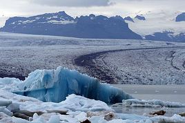
Pinacoladada · 12 June 2025 à 21:06 67 messages · 2 participants · 1 735 affichages | | | | GLACIER SVÍNAFELLSJÖKULL
Location:
64.00018, -16.89382 Parking 63.99950, -16.89350 Start of the trail
Loop hike of about 2.5 km.
Easy access. The proximity to the glacier is a major plus. Many icebergs are also trapped in the lake formed by the glacier’s melt. A really picturesque spot.
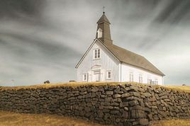
| | | HOFSKIRKJA CHURCH
Location: 63.90703, -16.70674
Built in 1884, it’s the last sod church to be constructed. In Iceland, there are six sod churches that are part of the cultural heritage, including this one. Even today, it still serves as a parish church.
Like in all these small churches, there’s a real sense of peace and serenity.
It’s surrounded by a cemetery where many graves are covered with a layer of vegetation, making the landscape truly unique.
| | | GLACIAL LAGOON FJALLSÁRLÓN (WEST)
Location:
63.99920, -16.37610 Turn left after 1.8 km 64.01090, -16.38845 Parking and start of the 300 m trail (one way) 64.01193, -16.39376 End of the trail
I’ll let you in on a little secret to get closer to this lake formed by the Fjallsjökull glacier. You need to take the road to the left right after the Hrútá river bridge. More precisely, this road is located between the Hrútá and Fjallsá river bridges.
Drive about 2 km on this gravel road and continue left when it splits until you reach a small parking area. There’s a trail starting from the parking lot that leads directly to the lake.
Another glacier, you might say? It’s impossible to stay indifferent in front of such natural beauty.
The lake sits at the base of a massive glacier, and several blue-tinted icebergs make the scene even more breathtaking.
| | | FJALLSÁRLÓN GLACIAL LAGOON (EAST)
Location:
64.01350, -16.35560 Left side 64.01630, -16.36510 Parking 64.01660, -16.36590 Start of the trail 64.01703, -16.37030 Viewpoint 1 64.01420, -16.37220 Viewpoint 2 64.01589, -16.36616 End of the trail
A 1.5 km loop trail that offers lovely viewpoints over the Fjallsárlón glacial lagoon, fed by the Fjallsjökull glacier.
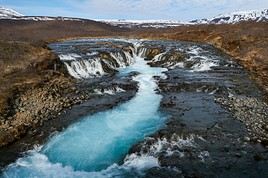
| | | JÖKULSÁRLÓN GLACIAL LAGOON
Location: 64.04803, -16.17955
Easy to access and very popular. This site is truly exceptional, which is why it’s one of the most visited places in Iceland. You’ll find restaurants, shops, and agencies offering boat tours.
It’s a small lagoon with a bluish hue, filled with massive icebergs that have broken off from the Breiðamerkurjökull glacier. Some icebergs drift toward the sea via the Jökulsá River, which connects the lagoon to the ocean.
| | | LITLANEFSFOSS AND HENGIFOSS
Location: 65.07331, -14.88057 Parking 65.07365, -14.88095 Trailhead 65.08306, -14.88320 Litlanefsfoss 65.09510, -14.88970 Hengifoss 65.08684, -14.88414 Footbridge Back to the parking lot
A 4.9 km loop hike that lets us discover the Litlanefsfoss and Hengifoss waterfalls.
Perseverance is key to get there since most of the trail is uphill. It’ll be easier on the way back!
From the parking lot, there’s a series of steps to climb. After that, a gravel trail leads us to a stunning waterfall: Litlanefsfoss. This waterfall is about 1.3 km from the parking lot.
Litlanefsfoss is surrounded by tall basalt columns. It’s truly breathtaking. I would’ve been just as enchanted if this was the only waterfall I saw. But the goal of our hike was to see Hengifoss, one of Iceland’s tallest waterfalls. So, we continued along a small dirt trail. By the way, you can spot its summit in the distance.
We walked and climbed... Finally, we got closer to Hengifoss. Just before reaching the waterfall, the trail runs along a steep slope beside the river.
When we went, the trail was in excellent condition. But since it’s a dirt path, I imagine it could be trickier to access in spring or after heavy rain.
Hengifoss is also set in a magical landscape. The surrounding rock displays different colored layers formed by ancient volcanic eruptions.
On the way back, we took a detour to the footbridge, which let us cross to the other side of the river. This gave us different viewpoints of both waterfalls.
We also discovered other waterfalls that weren’t visible from the opposite side.
The return trip offers stunning views of the valley.
| | | RJÚKANDI (RJÚKANDAFOSS)
Location:
65.33110, -15.07380 Parking 65.33350, -15.07950 Rjúkandi
Rjúkandi, also known as Rjúkandafoss, is the twelfth tallest waterfall in Iceland. It has a total height of 93 m.
Its impressive height makes it hard to miss. Despite being one of the few major waterfalls visible directly from the northern part of the main Route 1 (Ring Road), it sees few visitors.
A 0.6 km round-trip trail (total) leads to the base of this majestic waterfall.
| | | STUÐLAGIL CANYON
Location:
65.17516, -15.27079 Parking 65.17390, -15.27290 Stuðlafoss 65.16347, -15.30585 Viewpoint 1 65.16253, -15.30782 Viewpoint 2 65.16091, -15.31272 End of the trail
A 6 km round-trip hike to explore Stuðlagil Canyon, located in the middle of the Jökla River in eastern Iceland.
Stuðlagil is definitely one of Iceland’s most beautiful canyons, with its stunning volcanic organ pipes (basalt columns) and the turquoise color of the surrounding water.
The river’s color can vary depending on the season—from blue-green in summer to gray-brown when the Karahnjukar dam is overflowing and snow is melting into the river.
When we visited, the water was more of a gray color, but that didn’t affect the beauty of the landscape at all.
| | | SELFOSS AND DETTIFOSS
Location:
65.81212, -16.40068 Parking and trailhead 65.81347, -16.38620 Viewpoint 1 65.81468, -16.38591 Viewpoint 2 65.81564, -16.38765 Viewpoint 3 65.81604, -16.38740 Viewpoint 4
There are two roads leading to these waterfalls: Route 862 (west side) and Route 864 (east side). Route 862 is paved, unlike Route 864, which is gravel and in pretty rough shape. We chose Route 862.
There’s a 2.5 km (1-hour walk) trail starting from the parking lot. Dettifoss waterfall is about a 15-minute walk from the parking area.
Nearby, you’ll also find Selfoss waterfall. It’s made up of several smaller falls.
At the start of this hike, nothing suggests there are waterfalls in the area. The landscape is desert-like, with just big rocks in sight.
But the awe is complete when you get close to Dettifoss. It’s the most powerful waterfall in Europe. You can really feel its power up close.
Rainbows form when the sun is out. We were lucky enough to see quite a few.
| | | KRAFLA - VITI CRATER LAKE
Location:
65.71770, -16.75760 Parking 65.71766, -16.75655 Viewpoint 1 65.71570, -16.75218 Viewpoint 2 (end of the trail)
Krafla is a volcanic area still active today. The Viti crater is part of it.
We hiked to the top of the Viti crater. The climb is very easy, and we had a spectacular view of the area.
An emerald-colored lake fills the bottom of the crater. It's truly a magnificent spot!
In the past, we could hike around the crater. That’s no longer possible.
| | | KRAFLA - LEIRHNJÚKUR LAVA FIELD
Location:
65.71314, -16.77461 Parking and trailhead 65.72199, -16.78780 Viewpoint 1 65.72160, -16.78870 Viewpoint 2 65.72610, -16.79250 Landmark 65.72221, -16.79517 Viewpoint 3 65.71937, -16.79127 Viewpoint 4 65.71843, -16.79089 Viewpoint 5
Easy 4.8 km loop hike.
The Leirhnjúkur lava field is part of the Krafla volcanic zone. This area is covered in lava ejected during the 1984 volcanic eruption.
We start our hike on a dirt trail. Later, a wooden boardwalk was built to cross a field of fumaroles and solfataras. It’s really important not to stray off the marked paths because the ground can be unstable and very hot.
Throughout the hike, you’ll see sulfur deposits on the ground, smoke rising from the earth, and bubbling mud pools. The landscape is incredibly colorful in this area.
However, the scenery changes completely as you approach the lava field. Everything turns black, and the landscape looks totally transformed—like a massive bombing left everything scorched. It’s truly indescribable. You’ll feel like you’re on another planet.
| | | GEOTHERMAL SITE HVERIR (NÁMAFJALL)
Location:
65.64161, -16.80707 Parking 65.64135, -16.80814 Viewpoint
This geothermal site at the foot of Námafjall mountain is truly impressive. As soon as we arrived, the rotten egg smell hit us by surprise. A little scarf is a good idea for more sensitive noses!
A festival of colors unfolds before our eyes. The ground displays shades of yellow, orange, and gray. It’s dotted with huge solfataras and mud pots.
You need to be very careful and stay on the marked trails because the ground can be deceptive.
In some spots, you can really feel the underground activity. The steam escaping from a hole in the ground is accompanied by a deafening noise. You can’t even imagine the power that’s coming from it.
| | | HVERIR - GEOTHERMAL SITE HVERARÖND - BLUE LAGOON
65.63949, -16.84471 Parking
A stunning lake with a supernatural color is located near the Hverir geothermal site. The urge to take a dip fades pretty quickly when you see a sign warning that the water feeding the lake is over 100°C.
| | | GRJÓTAGJÁ - HOT SPRING CAVE
Location: 65.62639, -16.88299
The Grjótagjá cave is located along the same fissure as the Stóragjá cave in Iceland. The two caves are two kilometers apart.
At the entrance of the cave, it’s indicated that the water temperature stays between 43 and 46°C. Swimming is prohibited, and entering the cave is at your own risk due to the danger of falling rocks.
You’re only allowed to enter for observation or to take photos.
We ventured inside. The access is still easy. The interior of the cave is stunning. The multicolored walls reflect in the crystal-clear blue water, creating a breathtaking sight.
| | | STÓRAGJÁ - HOT SPRING CAVE
Location: 65.63825, -16.91005
Stóragjá is a cave located in Iceland. A long and immense fissure runs through this region, and the Stóragjá cave is situated along it. We went to visit it.
You have to go down a staircase that leads to the cave's entrance. After looking around a bit, you’ll find the entrance and spot a small ladder that lets you climb down inside.
The water temperature stays around 29°C. In the past, people could bathe here, but today it’s not recommended because the water may contain bacteria.
Note: When we were there, some people were bathing, and they mentioned the water wasn’t actually warm.
| | | GOÐAFOSS
Location:
65.68530, -17.54620 Parking and trailhead 65.68370, -17.54940 Viewpoint 1 65.68530, -17.54230 Viewpoint 2 65.68557, -17.54164 Viewpoint 3 65.68614, -17.54168 Footbridge 65.68344, -17.54807 Viewpoint 4 65.68297, -17.54858 Viewpoint 5
Hike of about 3 km round trip.
This waterfall is a very popular spot with tourists. We went there very early in the morning to avoid the crowds.
There’s a trail running along each side of the river, which lets you see the waterfall from different angles.
It’s truly remarkable because it’s made up of several cascades with an emerald-green hue.
Along the way, you can spot several caves carved into the rocks.
Goðafoss means "Waterfall of the Gods." According to legend, Þorgeir Þorkelsson, a lawmaker, is said to have thrown statues of the old Norse gods into this waterfall after Iceland’s parliament decided to convert the country to Christianity.
| | | Thanks so much for this super detailed account and the videos—they’ll really help us with our trip planned for July.
Have a great evening | | | ZIPLINE AKUREYRI
Location: 65.67842, -18.12628
This fantastic activity, supervised by very enthusiastic professional guides, takes place in the Glerárgil river canyon that runs through the center of Akureyri in Iceland. The scenery is truly stunning.
It includes an adventure course with five ziplines, forest trails, and educational stories.
The activity lasts 1 to 2 hours, depending on the group size and activity level.
| | | HOFSÓS - POOL BY THE SKAGAFJÖRÐUR FJORD
Location: 65.89580, -19.41096
Hofsós is a beautiful little village located by the Skagafjörður fjord in Iceland. Sure, this destination takes us a bit out of our way, but we really wanted to relax in the warm waters of their pool right by the fjord.
It’s good to know that all pools in Iceland use geothermal energy, allowing them to keep the water at a high temperature all year round.
There are a few steps to follow before each swim. First, you have to undress completely and take a shower. Most showers are in a shared space, and you need to thoroughly clean your private areas.
This pool is set in a magical landscape, straight out of a postcard. We enjoyed a wonderful moment of relaxation in the warm, soothing water.
| | | VÍÐIMÝRARKIRKJA CHURCH
Location: 65.53880, -19.47041
Free to visit, except for the interior. When you see this church, you really feel like you’re stepping back into the Viking era. It dates back to 1834 and is dedicated to the Virgin Mary and St. Peter.
The turf roof is regularly renewed, but much of the church’s framework is original.
If you want to visit the inside, you’ll need to get the key from the house next to the church. There’s a fee.
As for us, we just took a quick peek inside through the windows!
Behind the church, there’s a tiny cemetery set in an enchanting landscape. The place is so peaceful!
| Carnets similaires sur l'Islande: Trouvez des offres de séjours uniques avec nos partenaires All rights reserved © 2026 MyAtlas Group | 4 715 visiteurs en ligne depuis une heure! |