j'ai très envie de faire le trek de 17jr de zig zag tour de l'almapayao et huascaran "au pied des geants" mais il y a un hic c'est le passage de 3000 à 4650 du J3 au J4!!!!! carrément affolant!!! soit il y a une erreur dans leur topo soit....bref je ne trouve pas trace sur le net de leur trek.
qqn a-t-il fait ce trek?
que pouvez vous m'en dire?
quel niveau de difficulté?
merci d'avance
nadine
C'est sûr qu'en général il est conseillé de consacrer entre un et trois jours à s'acclimater. Et 3000m est une bonne altitude pour ça; c'est celle de Huaraz ou Cusco. Mais après, les 4600 m s'avalent sans difficulté le plus souvent. Le plus souvent parce qu'en fait, chacun réagit à sa manière.
Je n'ai pas le détail du trek mais : ce qui compte, c'est la différence d'altitude entre 2 nuits, pas l'altitude max de la journée. C'est quoi 4650 m, un col ou l'étape ? tour de l'Alpamayo, j'ai fait en autonome mais pas d'avis sur celui de zig zag si ce n'est que c'est un trek d'agence, normalement rodé et adapté au marcheur moyen pas entrainé donc a priori cool...
merci de ta réponse, à priori c'est le col passé et j'ai justement fait un mail à zig zag pour leur demander d'exprimer l'altitude des camps. Il semblerait qu'entre temps ils aient commencé à revoir la fiche et réduit à 110 m la fameuse étape
Pour toi un trekkeur moyen a les gambettes sufisamment solides pour le faire?
merci de ton avis en tout cas
J'ai fait ce trek en autonomie dans le sens inverse de celui proposé par Zig Zag et je vois bien de quelle montée il s'agit, je l'ai descendue 🙂.
Le terme "Rude montée" employée sur la fiche technique du trek Zig Zag est bien choisi, lol 😏.
Qu'est ce qui te fait flipper exactement ?
Les 1600m de dénivellés ? L'altitude ? L'acclimatation ?
L'acclimatation est bien le problème ici: de 3000 à 4600m, j'estime que c'est un peu n'importe quoi ... mais ça n'engage que moi.
Et ce d'autant qu'il y'a au moins un bon campement intermédiaire avant d'arriver à la laguna Cullicocha...
Essaie peut être de voir si tu ne peux pas trouver le trek équivalent sur d'autres voyagistes, tu devrais pouvoir en trouver un avec une étape intermédiaire.
ahhh ca me conforte dans l'idée que j'ai encore du bon sens!!! ce qui m'effraie c'est un dénivelé de 1600 sur une montée mortelle à une telle altitude...ce qui fait 3 contraintes en 1.
Pas trouvé d'autre T-O proposant le trek dans l'autre sens en avril. Si tu es mieux renseigné ta réponse sera la bienvenue
au fait pourquoi personne ne mentionne les caissons de décompression là bas? tous des trompe la mort ou bien?
NL
Ah oui en Avril.... normal, ça n'est vraiment pas la bonne saison !
T'es sûr que tu veux y aller en Avril ?
Si tu attends le mois de Juin par exemple, tu auras de bonnes chances d'avoir une meilleure météo, tu ne paieras pas le prix max des T-O et tu pourras ... choisir le T-O 😉.
Une autre option si tu ne pars pas seule et que vous etes un tant soi peu débrouillards: pleins de petites agences péruviennes peuvent organiser le trek comme vous le souhaitez à partir de 2 personnes.
A+
Samuel
PS: les caissons de décompression...ça ne sert pas à grand chose, le seul remède à un MAM sérieux étant la descente. Je considère les caissons comme un argument marketing des agences.
J'ai regardé l'itineraire.
C'est effectivement une étape classique. Beaucoup d'agence l'effectuent ainsi et elle est aussi proposée dans ce sens par Vincent Geus dans son livre sur les treks au Pérou.
Personnellement j'avais choisi de faire la boucle dans l'autre sens.
Bon, c'est plutôt 1500 m de montée, mais direct. Tu ne porteras pas ton fourbi et tu auras eu 2 nuits pour t'accoutumer : c'est pas vraiment extrême. Si les voyageurs mourraient comme des mouches ils auraient changé d'itinéraire ou de sens 😉
Quant au "caisson de décompression", que j'appellerai plutôt "caisson hyperbare", ce n'est pas un moyen "normal" de progression ou d'accoutumance à l'altitude mais un élément éventuel d'une trousse de secours. Dans le cas présent, pas forcément nécessaire : si qqu'un est malade à la Laguna Cullicocha il peut redescendre très vite. Et si tu survis à la première étape, le reste de l'itinéraire passera tout seul...
Bon voyage quand même.
d"accord d'accord....la météo en avril ça donne quoi? Pluie? neige? plaques de verglas? si ce n'est qu'une question de degrés c'est un d'étail mais la pluie pas trop....même pas du tout
Personne ne mentionne de villages ou de zone habitée sur ces treks? c'est le no man's land? Idem Huayhuash
je veux voir beaux paysages et hameaux, bref de l'authentique, de la couleur, pas que du caillou. Bouteilles d'eau peuvent s'acheter sur le chemin ou bien on est condamné à ces maudites pastilles?
autre question? top five des treks au perou (au cas ou huascaran mis de côté)
comparé aux treks de l'Equateur?
merci
Villages ? Pas de "vrai village" sur ce parcours. Quelques maisons, par exemple élévages de lamas et alpagas dans la plaine de Huillca.
Ce n'est pas le no man's land absolu.
Beaux paysages: pour la partie au nord de l'Alpamayo, yeessss !!! Beaux paysages en perspectives.
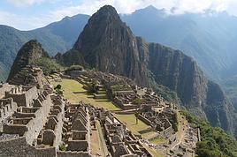
Tu peux voir des photos ici: http://voyageforum.com/v.f?post=772940;#772940 (voir surtout les photos à la fin du récit "Tour de l'alpamayo").
Bouteilles d'eau qui s'achètent en chemin ? Niet. C'est soit pastilles, soit eau bouillie.
Top five des treks au Pérou ?
Faudrait que je les aie tous faits pour avoir un avis pertinent sur la question.
Quant à l'Equateur... connait pas.
Bonsoir
Pour la période mieux vaut faire ce trek après le 15 mai .... avant c'est + ou - de la pluie ...
Pour avoir fait le trek de Los Cedros (nord de l'Alpamayo)
pas de problème pour la montée après une acclimatation de 2-3 jours.
Pas de villages mais de l'eau partout dans les torrents: purifiée avec un filtre Katadyn.
La nuit il gèle sous la tente: donc prévoir un bon duvet .
C B
Je ne connais pas l'itineraire en question mais le trek Alpamayo Nord commence par une interminable montee en effet. Je n'ai pas la carte ici, mais cela monte plus de 2000 metres si je me souviens bien. Par contre, tu peux camper au milieu de la montee (au canal d'irrigation). Fin avril, oui c'est quand je lai fait moi, avantage je n'ai rencontre aucun autre touriste.
Salut Tichodrome, marrant je te pourchassais sur Google Earth et Panoramio de photo en photo 😉 et j'ai perdu ta trace avant le Portachuelo sur le flanc est de la Cordillère, je te retrouve ici 😮. Alors est-ce que tu pourrais m'en dire un peu plus sur cette partie de la Blanca ? 🙂
J'espère à bientôt
"Si vous pensez que l'aventure est dangereuse, n'essayez pas la routine, elle est mortelle !!"
Tu veux savoir quoi ?
Y'a le découpage de mes étapes et la trace GPS sur ma page web ; liens directs (ou presque) :
Trace GPS : http://obiou.fr/Photos/Gps/index.html
Etape par étape, cartes et photos : http://obiou.fr/Photos/070710Perou/index.html
A ta disposition pour plus de renseignements ; mais pas avant le w-e, je pars pour 2 jours.
Pierre
PS : j'ai eu un mail perso concernant également mes images dans Panoramio sur l'Alpamayo de a...g...@hotmail.com c'est toi ?
Ce message pour avoir quelques renseignements au sujet du trek de l’Alpamayo que nous, mon amie et moi-même, avons l’intention de faire fin mai. Nous avons…
Nous avons prévu de faire le tour de l'Alpamayo en 10 jours (trek décrit dans le livre de Vincent Geus). Je recherche des personnes qui l'ont fait avec un…
Envisageant le tour de l'Alpamayo vers le 15 mai dans le sens Cashapampa - Hualcayan - col Punta Union - quebrada Santa Cruz, un aller-retour vers le camp de…
Nous aimerions faire le tour de l'Alpamayo pendant 6-7 jours en avril. Est-ce que quelqu'un pourrait me donner les différentes etépes et le dénivelé pour…
Hi,
We’re planning to do the 4-day trek from Mestia to Ushguli without an agency. The descriptions mention that there are accommodations at each stop, but we can’t find any details about them. Has anyone got info or feedback on this route?
We're planning to trek in Peru and Bolivia and would love to find some local agencies.
If you know any, could you share details on prices and, of course, the names of the agencies?
Which trek would you recommend?
Elocine
Je pars en autonomie totale sur un trek au Maroc (10jrs) Imilchil - Aghbalou.
Trouve t-on des cartouches gaz à vis (Coleman, Primus) à Marrakech (adresse) ou villages entre Imilchil - Aghbalou ?
Si non , trouve-t-on des cartouches Butagaz pour camping-gaz (petit volume 230 gr ...)
Merci d' avance pour vos réponses
Hello, I’d like to embark on a little trip in my home country, Switzerland. I’ll start walking from La Cure, heading toward Le Noirmont first, then I’ll improvise my route—but it’ll probably follow the French border... at least as far as Lac de Joux.
I’ll decide day by day how much farther to go after that. My goal is to stay in nature as much as possible, wander around for as long as I can, and restock food in villages or towns along the way.
I’m thinking of mostly camping, but we’ll see if I end up in a hotel or another campsite depending on my route.
I’d love to reach La Chaux-de-Fonds on foot... maybe even Delémont.
The whole thing should take about a week, give or take.
I’ll be bringing my dog, and I’m preparing for this as soon as I’m ready.
Any tips to make sure everything goes smoothly for us? Things I should know—or avoid? What about shepherds with their flocks of sheep? And isn’t hunting season open right now?
I’m not sure if what I’m planning is even doable, which is why I’m asking around.
This’ll be my first time doing something like this—wandering in nature *and* with a dog. I’m really excited for this adventure... and I need it. Thanks!
We’re really keen on ecosystems and want to hike in "natural" ancient forests—not planted woods or areas heavily degraded by human activity. Travel guides (like Lonely Planet) don’t provide much info on this. Could you point us to the most interesting spots?
Thanks in advance for your tips.
We wish you happy holidays and a fantastic 2026, full of discoveries!
Claire and Albert
Hi, this might not be the right section, but I’d like to know if it’s possible to start mountaineering with another person without necessarily hiring a guide. We’ve done quite a bit of hiking but not mountaineering—we’ll just do a half-day glacier course. After that, we were thinking of starting with La Grande Motte and the Pointe de la Traversière, which were recommended to us. Honestly, for things like roping up and knots, I’ll learn at home with lots of videos and a book.
Jaimerais savoir si quelqu'un aurait fait des treks sur le Ruwenzori et combien ça coute en moyenne, les infrastructures, les paysages la sécurité sur les lieux, merci beaucoup. J'attends avec impatience vos réponses.
We’re leaving in 9 days for a two-week trip to Madeira, mainly to hike.
From my research, I’ve found that since last year, access to most trails—and systematically for the most popular ones—is now paid. You have to pay an access fee of 4.50 € per person per classified hike in 2026, and even 10.50 € for the most iconic hike: Pico Arieiro to Pico Ruivo. When paying, you also have to choose a day and a 30-minute time slot for your start time. Of course, this reservation is neither changeable nor refundable, even if the weather that day is terrible.
Personally, given the massive influx of tourists to the island in recent years, I don’t mind paying a fee to help maintain the trails. Similarly, setting a limit on the number of people who can hike them per day is certainly preferable to preserve this priceless heritage.
However, what’s much less fair is that in reality, most of the available spots are reserved: 1/ for Madeira residents (which is normal); 2/ for "economic operators" (meaning local tour operators). For example, if you’re a non-resident (independent tourist), no booking is possible for the Pico Arieiro hike for an early morning start before September! So, unfortunately, we’ll have to skip this hike.
It’s the same issue for Ponta de São Lourenço, the 25 Fontes, Pico Ruivo... in short, all the most popular hikes. Oh well, we’ll skip those too!
So my question is: which hikes do you recommend where we won’t face the huge crowds that the others get? And where we can book the day before for the next day, taking the weather into account?
Finally, a quick accommodation question: we’ve booked the first week in Funchal, but I haven’t decided yet for the second week. Do you have any advice on where to stay in the south or north, preferably avoiding overly concrete-heavy and touristy spots?
I’m reposting about the logistics for Samaria Gorge.
I’d love to get recent info, especially about whether it’s possible to park my car in Omalos, do the hike, and then catch a bus back to my vehicle.
In theory, it’s doable, but when you check the KTEL website, there aren’t any feasible schedules listed. If anyone has recently organized this with reliable, verified details, I’d really appreciate it. Thanks in advance!
Hi there,
We’re flying from Montreal to Lyon this August to go hiking in the French Alps. We’ve rented a car and will be staying at campgrounds. We’re planning to do day hikes and want to stay a few days in one spot, do a few hikes, then move on to our next camping spot. Could you share your favorite spots or any recommendations for places to spend a few days with great hikes?
A few details:
We arrive in early August and leave in early September.
We’re looking for day hikes (or shorter), moderate difficulty, with a cumulative elevation gain of no more than 1000m, and of course, beautiful scenery!
We’d prefer not to drive too much—maybe it’s best not to head too far south and deal with unnecessary heat?
Along the same lines, if you know of any great campgrounds where we can start our hike directly without needing the car, we’d love to hear your suggestions!
Bonjour
Souhaitant faire de la randonnée sur cette île, je voudrais d'abord savoir quelle serait la période la plus favorable sachant que j'avais passé quelques jours en novembre 2018 pas pour cette activité mais plus pour une simple découverte de l'île et le temps n'était pas top notamment en montagne. Donc peut on choisir une organisation en étoile sachant que je louerai un véhicule avec éventuellement 2 points d'hébergement.
Je n'envisage pas d'intégrer une structure mais de partir à 2 et de s'organiser sauf si vous me conseillez une agence locale ou un guide local. Enfin même si je compte me procurer les différents supports, carte et topo guide plus gps je vous remercie de bien vouloir me communiquer les randos à faire en priorité
Merci beaucoup pour vos informations
I’m planning to do the Mercantour crossing following the Randoxygène route in mid-July.
I’m used to hiking in the mountains, but I sometimes get vertigo, for example on ridges with drops on both sides. I wanted to check if there are any T4 or T3-T4 sections and find out if there are any very exposed passages—and if so, where—so I can plan an alternative route.
Can anyone give me some info on this?
Thanks!
I’m planning a trip around Cap Corse and the AGRIATES in 2026, from May 8th to 15th (there are still 2 spots left, by the way! Just DM me if you're interested).
I’d love to know which hikes are worth prioritizing in the AGRIATES. We’ll be staying in SALECCIA for two days as our base—what should we focus on from there?
A round trip to IGNHU beach? Any other suggestions?
For Ostricano, I think it’s too far for a round trip...
Thanks for your tips!
Have a great day,
Anie, Toulouse
I’d like to get some info about the GR10 Pyrenees traverse. I need help planning the daily stages and accommodations—my wife isn’t an experienced hiker but walks a lot, so I’d like to schedule shorter walking days and thus a longer overall trip in terms of number of days.
Could anyone give me some help and advice?
Best regards,
New to this forum, I’m planning a pretty big project for 2028.
I’m heading to Nepal to do a trek from Kathmandu all the way to Everest Base Camp (a cool 5,300 m 😄).
This trek is a bit special because even though I’ll be part of a group, I’m going solo (so far, no problem—I’m used to it). But it’s my first real trek, and it’s also a humanitarian one: once I reach base camp, I’ll stay an extra week to help clean up the waste left by tens of thousands of climbers! Since I’m originally from South America, from two countries that share the Andes, I have a deep respect for mountains—they fascinate me. So Everest… it’s kind of the trip of a lifetime!
So, a little question for those who’ve done treks to Everest before… any tips for good mental preparation (I’m already working on the physical side)?
Hi there, I’m planning the Annapurna Circuit for March 2027 and I’m looking for a local agency with a local guide—preferably French-speaking—to arrange this trek for us. Any suggestions? Thanks
Hello!
We’re spending a few days in Toraja country at the end of May. We’d love to do a day trek—taking our time—on a route that’s stunning in terms of scenery, but not a level 5 in difficulty!
Any suggestions you can share, please?
Thanks in advance
I’d like to do the Mare a Mare Sud in May over 4 days. I’ve found quite a few places to stay along the route, but I’m stuck on the start and finish.
I’ll be arriving by plane on Sunday evening and would like to start pretty early on Monday morning. Ideally, accommodation right at the trailhead (Alzu di Gallina) would be amazing, but I can’t find anything. Any tips?
Also, for the transfer from Figari Airport to Porto Vecchio or Alzu di Gallina?
At the end, I’d like to pick up a rental car—any advice on that too?
I’m traveling solo by plane to Catania in May and plan to hike the northern side of Etna, starting from Linguaglossa where I’ll arrive by bus. After that, I’d love some info on how to get up to Piano Provenzana (shuttles or hitchhiking), since it seems there’s no public transport except in the summer. Can you sleep there in a free or cheap refuge, or camp? And how far up can you go without having to hire a guide? Thanks in advance. Bernard.
Bonjour a tous,
je pars en voyage au Maroc en aout et nous allons commencer par nous arrêter a Chefchaouen(nous sommes en voiture).
Ma question: quelqu'un peut il m'indiquer un itinéraire de rando en boucle d'entre 5 et 7 jours aux départ de Chefchaouen dans le parc de Talassemtane passant si possible par le pont de dieux?Ou un guide papier qui en reunis quelques uns?
Nous privilégions le camping sauvage et les gites.
Merci d'avance
Hi there, for those who’ve been recently—is it possible to find other solo travelers in March on the island to share transport or room costs? It doesn’t seem easy to travel on a budget.
If you have any recommendations for simple lodgings or places with dorms, I’d love to hear them.
For those who’ve done multi-day treks while moving around: do you need to bring your own sleeping bag? I’d love to hear about itineraries you’ve done without a guide, just with a map and GPS.
Thanks, and have a great day!
Hi everyone!
We’re planning a 15-day road trip to Scotland this summer, specifically to explore and hike on Lewis and Harris—places we’ve never been before. We’ve visited other islands on previous road trips in Scotland (we usually go in April for a week). This would be our first time in Scotland in the summer and for 15 days. We’re looking at late August to early September.
I’m currently drafting the itinerary. We’d be crossing from Ullapool and were thinking of spending 3 nights on Harris and 4 nights on Lewis.
Does that sound balanced to you? Is it better to keep the same accommodation on Harris and the same on Lewis to explore the area? I’d love to hear about any past experiences you’ve had on these islands.
Thanks!
Hi there, I’m trying to leave for 15 days very soon to São Vicente. I’m either looking to join an agency or figure things out on my own to go hiking on one of these islands or both. From what I’ve seen, it’s not easy to organize with local transport, so it gets expensive. Can I use the services of a small local agency? I’m looking for the simplest way to hike for several days. Also, how do you get from São Vicente to São Nicolau? Thanks in advance and have a great day!
Aichatou
I’ve been wanting to do this for several years, and this year’s the one. Next September, I’ll be trekking in Tusheti (Georgia), from Omalo to Shatili.
Of course, I won’t be renting a vehicle that’d just sit unused. No problem getting to Pshaveli, but from there to Omalo, it’s a dirt road (still the case?)
There must be some form of public transport since there are so many guesthouses, and not all travelers come in a 4x4.
If any of you have been to Omalo, could you confirm that these shared transports exist and how often they run?
we’re planning a trip to Yellowstone and hoping to do a three-day backcountry hike if we get a permit.
if any of you have done this before, could you let me know if it’s possible to find water along the way? And if we can transport it, are we allowed to use a stove?
Hello,
I’ll be in Nepal from March 6th to 29th (we’re flying into Kathmandu via Varanasi and leaving via Delhi).
I’m a bit confused about the regulations requiring a guide.
My wife and I (we’re 63 and 64) aren’t experienced trekkers—we’re more used to walking on terrain with very moderate elevation changes. I’m looking for fairly easy hikes, possibly day trips.
Here are my questions:
- Does the Poon Hill trek from Pokhara require a guide, or is it better to go through a local agency? (I’ve seen a lot of them offering 4-day packages)
- I’d like to do a few multi-day hikes around Jomsom (Kagbeni, Mukitinath, Lupra, Marpha)... Do you need a guide for those, and can you find accommodations easily without booking in advance?
Last question—I’m really hesitant to lug around a sleeping bag or down jacket during our 6 weeks in India. Can you easily find these kinds of items at reasonable prices in Pokhara?
Thanks in advance for any tips you can share!
Yann
I’m a 56-year-old man who’s done several treks in Nepal and elsewhere. Also passionate about photography.
I’m looking for one or more people to form a group for a trek in Nepal. The trek is the Annapurna and Manaslu circuit (24 days), including a stop at Tilicho Lake. I’ve got a great itinerary and the local company seems solid. The price is around $1600.
I’ll be in Nepal from April 5 to May 12, 2026, so the trek would need to happen within those dates.