Skip to content
Vendée

Travel guide

Vendée

★ 3 · last edited May 25, 2020 · 2 versions

With its 250-kilometre coastline, long beaches, and high sunshine levels, the Vendée has become a benchmark for seaside tourism on the Atlantic coast. It also boasts islands like Noirmoutier and Île d'Yeu, which draw large crowds in season, and above all, Le Puy du Fou, now a global reference for theme parks.

Overview of the Vendée
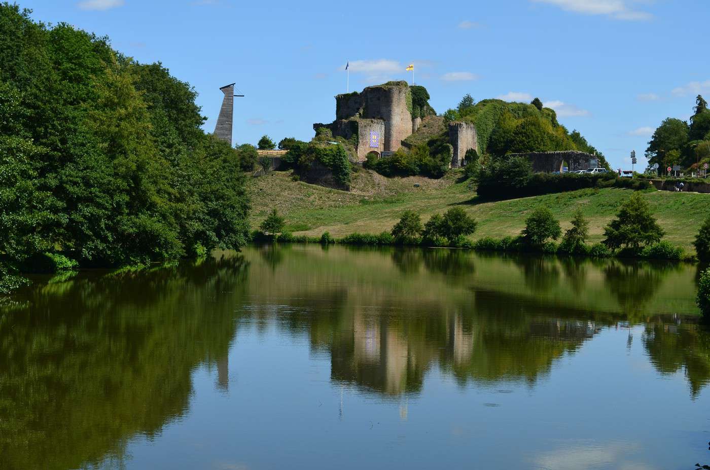
Château de Tiffauges, Vendée, France
Château de Tiffauges, Vendée, France · © VoyageForum

Key facts

  • Type de lieu: department.
  • Localisation:
  • Heure locale: Heure : Vendée
  • Code département: 85.
  • Départements limitrophes:
  • Sous-préfectures: Les Sables-d'Olonne, Fontenay-le-Comte.
  • Nombre de communes: 267.
  • Population: 662,122 inhabitants (2014).
  • Superficie: 6,719.59 km².
  • Densité: 99 inhabitants/km².
  • Point le plus haut:
  • Point le plus bas:
  • Littoral:
  • Intérêts (rated ): Nature / ; Culture ; Relaxation-holidays

Climate and weather

Sea temperature throughout the year

Jan.Feb.Mar.Apr.MayJun.Jul.Aug.Sep.Oct.Nov.Dec.
Vendée111111121416182018171412

Tourism

With its 250-kilometre coastline, long beaches, and high sunshine levels, the Vendée has become a benchmark for seaside tourism on the Atlantic coast. It also boasts islands like Noirmoutier and Île d'Yeu that draw large crowds in season, and above all, Puy du Fou, now a global reference for theme parks.
Further information

Brétignolles-sur-Mer

A seaside resort with a long beach where you can go surfing.

Overview of Brétignolles-sur-Mer

A Vendée seaside resort with a long beach where you can go surfing.

Key facts

  • Type of place: small town.
  • Tourist interest: (worth a stop if you are in the area).
  • Location:
  • Distances:
  • Local time: Heure : 19438.
  • Population: 4,419 inhabitants (2014).
  • Area: 27.33 km².
  • Altitude: sea level.

History of Brétignolles-sur-Mer

What to see and do in Brétignolles

In the surrounding area

Climate and weather in Brétignolles

Like the rest of the coast, the area has an oceanic climate—mild and humid year-round, with a noticeable presence of winds that can sometimes blow as storms in late autumn and early winter. That said, the coastline is less rainy than inland areas, winds are stronger, and temperatures are cooler despite good sunshine.

Sea temperature throughout the year

Jan.Feb.Mar.Apr.MayJun.Jul.Aug.Sep.Oct.Nov.Dec.
Brétignolles111111121416182018171412

Transport

Getting there

Getting around

Accommodation

Food

Useful addresses

Further information

View guide page: Brétignolles-sur-Mer

Tiffauges Castle

This 11th-century fortress was once home to Gilles de Rais. Medieval shows are regularly held here during the season.

Overview of the castle

This 11th-century fortress was once home to Gilles de Rais. Medieval shows are regularly held here during the season.

  • Tourist interest: (worth seeing).

History of the castle

What to see and do

Practical information

  • Location:
  • Address: 85130 Tiffauges.
  • Opening hours:
  • Price:
  • How to get there:

What to see nearby

Additional information

View guide page: Tiffauges Castle

Fontenay-le-Comte

This sub-prefecture in Vendée has a historic centre with some old buildings.

Overview of Fontenay-le-Comte

This sub-prefecture in Vendée has a historic centre with some old buildings.

Key Details

  • Type of place: small town.
  • Tourist interest: (worth a stop if you are in the area).
  • Location:
  • Distances:
  • Local time: Heure : 19441.
  • Population: 13,609 inhabitants (2014).
  • Area: 34.16 km².
  • Altitude: from 2 to 68 m.

History of Fontenay-le-Comte

What to See and Do

In the Surrounding Area

Climate and Weather

Transport

Getting There

Getting Around

Accommodation

Food and Drink

Useful Addresses

Further Information

View guide page: Fontenay-le-Comte

Noirmoutier Island

This island of forests, salt marshes, and dunes is a tourist destination. Visitors come for its beaches, walks, Noirmoutier Castle, and the Passage du Gois—a submersible road linking the island to the mainland and one of Noirmoutier’s main attractions.…

Read the full guide: Noirmoutier Island

Île d'Yeu

Close to the mainland, the island lives off fishing and tourism. It has several lighthouses, a few military buildings, and above all very beautiful landscapes—sometimes wild—where beaches, dunes, moors, and cliffs blend together. Hiking is possible here.

Overview of Île d'Yeu

Around twenty kilometres from the mainland, the island lives off fishing and tourism. It has several lighthouses, a few military buildings, and above all very beautiful landscapes—sometimes wild—where beaches, dunes, moors, and cliffs blend together. Hiking is possible here.

Key facts

  • Tourist interest: (recommended).
  • Location:
  • Local time: Heure : 19443
  • Main town: Port-Joinville.
  • Population: 4,809 inhabitants (2017).
  • Area: 24.66 km²
  • Density: 195 inhabitants/km²
  • Highest point: Saint-Sauveur (32 m).
  • Coastline:

History of Île d'Yeu

Environment

Wildlife and flora

Precautions

What to see on Île d'Yeu

Nearby

La Barre de Monts, Vendée, France
La Barre de Monts
This locality primarily serves as a departure point for boats to Île d'Yeu. One of its hamlets, Fromentine, is also a seaside resort.

What to do on Île d'Yeu

Climate and weather on Île d'Yeu

Sea temperature throughout the year

Jan.Feb.Mar.Apr.MayJun.Jul.Aug.Sep.Oct.Nov.Dec.
Île d'Yeu111111121416182018171412

Transport

Getting there

Getting around

Accommodation

Food

Useful addresses

Further information

View guide page: Île d'Yeu

La Barre de Monts

This locality primarily serves as a departure point for boats to Île d'Yeu. One of its hamlets, Fromentine, is also a seaside resort.

Overview of La Barre de Monts

This locality primarily serves as a departure point for boats to the Île d'Yeu. One of its hamlets, Fromentine, is also a seaside resort.

Key Information

  • Type of place: small town.
  • Tourist interest: (worth a stop if you are in the area).
  • Location:
  • Distances:
  • Local time: Heure : 19444.
  • Population: 2,184 inhabitants (2014).
  • Area: 27.29 km².
  • Altitude: sea level.

History of La Barre de Monts

What to See and Do

In the Surrounding Area

Climate and Weather

Like the rest of the coast, the area has an oceanic climate, mild and humid year-round with a noticeable presence of winds that can sometimes blow as storms in late autumn and early winter. That said, the coastline is less rainy than inland areas, with stronger winds and lower temperatures despite good sunshine.

Sea Temperature Throughout the Year

Jan.Feb.Mar.Apr.MayJun.Jul.Aug.Sep.Oct.Nov.Dec.
La Barre de Monts111111121416182018171412

Transportation

Getting There

Getting Around

Accommodation

Dining

Useful Addresses

Further Information

View guide page: La Barre de Monts

La Faute-sur-Mer

The southernmost seaside resort in the department, the town is twinned with the small neighbouring port of L'Aiguillon-sur-Mer.

Overview of La Faute-sur-Mer

It’s the southernmost seaside resort in the department. It’s twinned with the small neighbouring port of L'Aiguillon-sur-Mer.

Key Facts

  • Type of place: village.
  • Tourist interest: (worth a stop if you are in the area).
  • Location:
  • Distances:
  • Local time: Heure : 19445.
  • Population: 684 inhabitants (2014).
  • Area: 7.26 km².
  • Altitude: from -2 m to 17 m.

History of La Faute-sur-Mer

What to See and Do

In the Surrounding Area

Climate and Weather

Like the rest of the coast, the town has an oceanic climate, mild and humid in all seasons with a noticeable presence of winds that can sometimes blow as storms in late autumn and early winter. That said, the coastline is less rainy than inland areas, winds are stronger, and temperatures are lower despite good sunshine.

Sea Temperature Throughout the Year

Jan.Feb.Mar.Apr.MayJun.Jul.Aug.Sep.Oct.Nov.Dec.
La Faute-sur-Mer111111121416182018171412

Transport

Getting There

Getting Around

Accommodation

Food and Drink

Useful Addresses

Further Information

View guide page: La Faute-sur-Mer

La Roche-sur-Yon

It is the prefecture of Vendée. It is not particularly touristy.

Overview of La Roche-sur-Yon

It is the prefecture of Vendée. It is not particularly touristy.

Key facts

  • Type of place: city.
  • Tourist interest: (worth a stop if you are in the area).
  • Location:
  • Distances:
  • Local time: Heure : 19446.
  • Population: 53,162 inhabitants (2014).
  • Area: 87.79 km².
  • Altitude: from 32 to 94 m.

History of La Roche-sur-Yon

What to see and do

In the surrounding area

Climate and weather

Transport

Getting there

Getting around

Accommodation

Food

Useful addresses

Further information

View guide page: La Roche-sur-Yon

La Tranche-sur-Mer

A busy seaside resort in high season, especially popular with surfers. It faces the Île de Ré.

Overview of La Tranche-sur-Mer

A busy seaside resort in high season, especially popular with surfers. It faces the island of Ré (Île de Ré).

Key facts

  • Type of place: small town.
  • Tourist interest: (worth a stop if you are in the area).
  • Location:
  • Distances:
  • Local time: Heure : 19447.
  • Population: 2,818 inhabitants (2014).
  • Area: 21.04 km².
  • Altitude: sea level.

History of La Tranche-sur-Mer

What to see and do

In the surrounding area

Climate and weather

Like the rest of the coast, the area has an oceanic climate—mild and humid year-round, with frequent winds that can occasionally reach storm force in late autumn and early winter. That said, the coastline is less rainy than inland areas, with stronger winds and slightly lower temperatures despite plenty of sunshine.

Sea temperature throughout the year

Jan.Feb.Mar.Apr.MayJun.Jul.Aug.Sep.Oct.Nov.Dec.
La Tranche-sur-Mer111111121416182018171412

Getting around

How to get there

Getting around

Where to stay

Where to eat

Useful addresses

Further information

View guide page: La Tranche-sur-Mer

Puy du Fou

On the outskirts of the Vendée department, in the commune of Les Epesses. It is one of France's top theme parks, with an increasingly international reputation for its shows and attractions.

Overview of the theme park

On the outskirts of the Vendée department, in the commune of Les Epesses. It is one of France's top theme parks in terms of attendance, with an increasingly international reputation for its shows and attractions.

  • Tourist interest: (must-see or highly recommended).

Attractions

Facilities

Practical information

  • Location:
  • Number of visitors: 2.26 million (2016).
  • Address: 85590 Les Epesses.
  • Opening hours:
  • Price:
  • How to get there:

Nearby sights

Additional information

View guide page: Puy du Fou

Les Herbiers

It is the "capital" of the Vendée bocage and the third-largest town in the department.

Overview of Les Herbiers

It is the "capital" of the Vendée bocage and the third-largest town in the Vendée department.

Key Facts

  • Type of place: small town.
  • Tourist interest: (worth a stop if you are in the area).
  • Location:
  • Distances:
  • Local time: Heure : 19449.
  • Population: 16,032 inhabitants (2014).
  • Area: 88.87 km².
  • Altitude: from 69 to 245 m.

History of Les Herbiers

What to See and Do in Les Herbiers

In the Surrounding Area

Climate and Weather in Les Herbiers

Transportation

Getting There

Getting Around

Accommodation

Dining

Useful Addresses

Additional Information

View guide page: Les Herbiers

Les Sables-d'Olonne

Both a fishing port, a marina, and a seaside resort (alongside Olonne-sur-Mer), one of the most popular in the season. It’s often called the "tourist capital of the Vendée coastline."

Overview of Les Sables-d'Olonne

It’s both a fishing port, a marina, and a seaside resort (alongside Olonne-sur-Mer), one of the most popular in the season. In a way, it’s the "tourist capital of the Vendée coastline." Since 2019, the town has been the result of the merger of Château-d'Olonne, Olonne-sur-Mer, and the former Les Sables-d'Olonne, making the new entity the second most populous municipality in the Vendée department.

Key Facts

  • Type of place: small town.
  • Tourist interest: (worth seeing).
  • Location:
  • Distances:
  • Local time: Heure : 19450.
  • Population: 44,017 inhabitants (2017).
  • Area: 8.70 km².
  • Altitude: sea level.

History of Les Sables-d'Olonne

What to See and Do in Les Sables-d'Olonne

In the Surrounding Area

Climate and Weather in Les Sables-d'Olonne

Like the rest of the coast, the town has an oceanic climate, mild and humid year-round, with a noticeable presence of winds that can sometimes blow as storms in late autumn and early winter. That said, the coastline is less rainy than inland areas, winds are stronger, and temperatures are cooler despite good sunshine.

Sea Temperature Throughout the Year

Jan.Feb.Mar.Apr.MayJun.Jul.Aug.Sep.Oct.Nov.Dec.
Les Sables-d'Olonne111111121416182018171412

Transportation

Getting There

Getting Around

Accommodation

Dining

Useful Addresses

Further Information

View guide page: Les Sables-d'Olonne

Luçon (85)

This town of 10,000 inhabitants has a notable religious heritage, including a small Gothic cathedral.

Overview of Luçon

This town of 10,000 inhabitants has a notable religious heritage, including a small Gothic cathedral.

Key facts

  • Type of place: small town.
  • Tourist interest: (worth a stop if you are in the area).
  • Location:
  • Distances:
  • Local time: Heure : 19451.
  • Population: 9,313 inhabitants (2014).
  • Area: 31.42 km².
  • Altitude: from 1 to 40 m.

History of Luçon

What to see and do in Luçon

In the surrounding area

Climate and weather in Luçon

Transport

Getting there

Getting around

Accommodation

Food

Useful addresses

Further information

View guide page: Luçon (85)

Mallièvre

A charming commune south of Cholet, known for its beautiful manor houses and historic architecture.

Overview of Mallièvre

A small commune south of Cholet with a certain charm due to its beautiful manor houses and historic architecture.

Key Details

  • Type of place: village.
  • Tourist interest: (worth a stop if you are in the area).
  • Location:
  • Distances:
  • Local time: Heure : 19452.
  • Population: 257 inhabitants (2014).
  • Area: 0.22 km².
  • Altitude: from 122 to 160 m.

History of Mallièvre

What to See and Do in Mallièvre

In the Surrounding Area

Climate and Weather in Mallièvre

Transportation

Getting There

Getting Around

Accommodation

Dining

Useful Addresses

Additional Information

View guide page: Mallièvre

Saint-Gilles-Croix-de-Vie

A fishing port, marina, and seaside resort on the Vendée coast.

Overview of Saint-Gilles

It is both a fishing port, a marina, and a seaside resort on the Vendée coast.

Key facts

  • Type of place: small town.
  • Tourist interest: (worth a stop if you are in the area).
  • Location:
  • Distances:
  • Local time: Heure : 19453.
  • Population: 7,530 inhabitants (2014).
  • Area: 10.46 km².
  • Altitude: sea level.

History of Saint-Gilles-Croix-de-Vie

What to see and do

In the surrounding area

Climate and weather

Like the rest of the coast, the town has an oceanic climate, mild and humid in all seasons with a certain presence of winds that can sometimes blow as storms in late autumn and early winter. That said, the coastline is less rainy than inland areas, winds are stronger, and temperatures are lower despite good sunshine.

Sea temperature throughout the year

Jan.Feb.Mar.Apr.MayJun.Jul.Aug.Sep.Oct.Nov.Dec.
Saint-Gilles-Croix-de-Vie111111121416182018171412

Transport

Getting there

Getting around

Accommodation

Eating

Useful addresses

Further information

View guide page: Saint-Gilles-Croix-de-Vie

Saint-Hilaire-de-Riez

The seaside resort faces the Île d'Yeu. It is home to many salt marshes within its territory.

Overview of Saint-Hilaire

It’s a seaside resort facing the Île d'Yeu. The municipality is also home to many salt marshes within its territory.

Key Facts

  • Type of place: small town.
  • Tourist interest: (worth a stop if you are in the area).
  • Location:
  • Distances:
  • Local time: Heure : 19454.
  • Population: 11,435 inhabitants (2014).
  • Area: 48.83 km².
  • Altitude: sea level.

History of Saint-Hilaire-de-Riez

What to see and do in Saint-Hilaire

In the surrounding area

Climate and weather in Saint-Hilaire

Like the rest of the coast, the area has an oceanic climate—mild and humid year-round, with a noticeable presence of winds that can sometimes blow as storms in late autumn and early winter. That said, the coastline is less rainy than inland areas, winds are stronger, and temperatures are slightly lower despite good sunshine.

Sea temperature throughout the year

Jan.Feb.Mar.Apr.MayJun.Jul.Aug.Sep.Oct.Nov.Dec.
Saint-Hilaire111111121416182018171412

Transport

Getting there

Getting around

Accommodation

Eating

Useful addresses

Further information

View guide page: Saint-Hilaire-de-Riez

Saint-Jean-de-Monts

A fairly popular seaside resort located just before Noirmoutier.

Overview of Saint-Jean-de-Monts

It’s a fairly popular seaside resort located just before the Noirmoutier Island.

Key facts

  • Type of place: small town.
  • Tourist interest: (worth a stop if you are in the area).
  • Location:
  • Distances:
  • Local time: Heure : 19455.
  • Population: 8,485 inhabitants (2014).
  • Area: 62.25 km².
  • Altitude: sea level.

History of Saint-Jean-de-Monts

What to see and do

In the surrounding area

Climate and weather

Like the rest of the coast, the area has an oceanic climate—mild and humid year-round, with a noticeable presence of winds that can sometimes blow as storms in late autumn and early winter. That said, the coastline is less rainy than inland areas, winds are stronger, and temperatures are cooler despite good sunshine.

Sea temperature throughout the year

Jan.Feb.Mar.Apr.MayJun.Jul.Aug.Sep.Oct.Nov.Dec.
Saint-Jean-de-Monts111111121416182018171412

Transport

Getting there

Getting around

Accommodation

Food

Useful addresses

Further reading

View guide page: Saint-Jean-de-Monts

Vouvant

This small village surrounded by medieval ramparts is listed among "the most beautiful villages of France". It is also home to many painters and galleries.

Overview of Vouvant

This small village surrounded by medieval ramparts is listed among "the most beautiful villages of France". It is also home to many painters and galleries.

Key Facts

  • Type of place: village.
  • Tourist interest: (worth a stop if you are in the area).
  • Location:
  • Distances:
  • Local time: Heure : 19456.
  • Population: 861 inhabitants (2014).
  • Area: 20.42 km²
  • Altitude: from 35 to 110 m.

History of Vouvant

What to see and do in Vouvant

In the surrounding area

Climate and weather in Vouvant

Transport

Getting there

Getting around

Accommodation

Food

Useful addresses

Further information

View guide page: Vouvant

Coast of Light

This is the name given to the Vendée coastline, which includes around twenty seaside resorts grouped into a tourist hub.

Overview of the Coast of Light

This is the name given to the Vendée coastline, which includes around twenty seaside resorts grouped into a tourist hub.

Key details

  • Type de lieu: coast.
  • Intérêt touristique: (worth seeing).
  • Localisation:
  • Localités principales:
  • Longueur:
  • Population:
  • Site internet:

History of the Coast of Light

Environment

Wildlife and flora

Precautions

What to see and do

Nearby

Climate and weather

The entire coast has an oceanic climate, mild and humid in all seasons with a certain presence of winds that can sometimes blow as storms in late autumn and early winter. That said, the coastline is less rainy than inland areas, winds are stronger, and temperatures are lower despite good sunshine.

Sea temperature throughout the year

Jan.Feb.Mar.Apr.MayJun.Jul.Aug.Sep.Oct.Nov.Dec.
Coast of Light111111121416182018171412

Transport

Getting there

Getting around

Accommodation

Food

Further reading

View guide page: Coast of Light

Something wrong or out of date? Report this page