Skip to content
What to See in Benin

Travel guide · Benin

What to See in Benin

last edited Dec 11, 2019

UNESCO World Heritage Sites

Benin has two (groups of) sites inscribed on the UNESCO World Heritage list:

  • W-Arly-Pendjari Complex *** (2017): This is a transboundary group of several parks and reserves listed by UNESCO, including the Pendjari Park (Benin), the W Park (Benin, Burkina, Niger), and the Arly Reserve (Burkina).
Royal Palaces of Abomey (1985)
A UNESCO World Heritage Site, this is a complex of royal palaces, part of which houses the country's main historical museum.

The Coast

Cotonou
Located on the coast, it is the country's economic capital. Its main tourist attraction is the Dantokpa Market, the largest in West Africa.
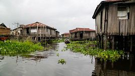
Ganvié, Bénin
Ganvié
A highly tourist-oriented lakeside city, Ganvié is built on Lake Nokué. It’s nicknamed the "Venice of Africa.".
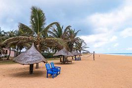
Grand Popo, Bénin
Grand Popo
On the Togolese border, the town attracts many tourists for its beaches and expatriates for its holiday opportunities. Several "traditional" villages can be visited in the surrounding area.
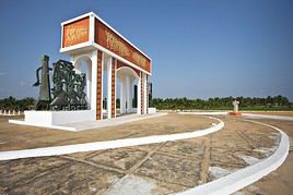
Ouidah, Bénin
Ouidah
The former slave port has various remnants from that era, as well as a beautiful basilica and the Voodoo temple of pythons.
Porto Novo
Benin’s capital offers visitors a few palaces, museums, and colonial-era buildings.

Natural Heritage

Mono River
Canoe trips let you see many crocodiles and hippopotamuses at the mouth of this river, which marks the border between Benin and Togo.
Lake Nokoué
This is where Ganvié, the "Venice of Africa," and Cotonou, the economic capital of Benin, are located. The lake, where travel is by canoe, is also home to many birds.

The Interior

Caution: The far north of the country (W and Pendjari park region) is currently strongly advised against for security reasons by the French Ministry of Foreign Affairs.
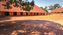
Abomey, Bénin
Abomey
The historic capital of the country is home to the royal palaces, one of Benin’s two UNESCO World Heritage sites. A few kilometers away, you can also visit the underground city of Agongointo.
Dassa-Zoumé
Surrounded by forests, the town is a pilgrimage site dedicated to the Virgin Mary.
Djougou
It's a large city in north-central Benin, near Togo. It has a large market.
Kétou
This southern city has a strong Yoruba culture. You can visit a royal palace (with the chance to meet the current king), traditional fortifications, and a lively market.
Malanville
This is the border town with Niger, not far from W National Park. It has a large market.
Natitingou
In northwest Benin, the town typically serves as a base for exploring the surrounding area (traditional Somba villages, Pendjari Park, Tanongou waterfall).
Parakou
It’s the major urban center in the region, featuring a large market and an open-air museum showcasing traditional housing styles.
Savalou
A mid-sized town in southern Benin surrounded by beautiful hills, with a royal palace, a museum, and traditional villages in its vicinity.
Save
It’s around Save that you’ll find enormous boulders popular with climbers.

Natural Heritage

Tanongou Waterfall
A beautiful waterfall near the town of Natitingou.
Atacora Mountains
Near Natitingou, in the northwest of the country and bordering Togo, this pretty range of high hills is home to several traditional Somba villages.
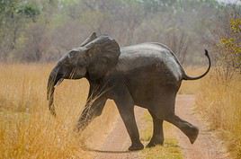
Parc National de la Pendjari, Bénin
Pendjari National Park
Continuing from Arly National Park in Burkina Faso, Pendjari also boasts abundant and diverse wildlife (birds, elephants, hippos, lions, cheetahs, etc.). Part of the W-Arly-Pendjari Complex, it is a UNESCO World Heritage site.
W National Park
Straddling Niger, Benin and Burkina Faso, W is a UNESCO-listed site as part of the transboundary WAP complex (W-Arly-Pendjari). It is renowned for its wildlife (lions, elephants, hippos, giraffes, crocodiles, birds...).

Recommended

★★★

Ganvié

A highly tourist-oriented lakeside city, Ganvié is built on Lake Nokué. It’s nicknamed the "Venice of Africa."
★★★

Pendjari National Park

Continuing from Arly National Park in Burkina Faso, Pendjari also boasts abundant and diverse wildlife (birds, elephants, hippos, lions…
★★★

W National Park

Straddling Niger, Benin and Burkina Faso, W is a UNESCO-listed site as part of the transboundary WAP complex (W-Arly-Pendjari). It is…

Worth a look / Other

★★

Abomey

The historic capital of the country is home to the royal palaces, one of Benin’s two UNESCO World Heritage sites. A few kilometers…
★★

Tanongou Waterfall

A beautiful waterfall near the town of Natitingou.
★★

Mono River

Canoe trips let you see many crocodiles and hippopotamuses at the mouth of this river, which marks the border between Benin and Togo.
★★

Grand Popo

On the Togolese border, the town attracts many tourists for its beaches and expatriates for its holiday opportunities. Several…
★★

Kétou

This southern city has a strong Yoruba culture. You can visit a royal palace (with the chance to meet the current king), traditional…
★★

Atacora Mountains

Near Natitingou, in the northwest of the country and bordering Togo, this pretty range of high hills is home to several traditional Somba…
★★

Natitingou

In northwest Benin, the town typically serves as a base for exploring the surrounding area (traditional Somba villages, Pendjari Park…
★★

Ouidah

The former slave port has various remnants from that era, as well as a beautiful basilica and the Voodoo temple of pythons.
★★

Royal Palaces of Abomey

A UNESCO World Heritage Site, this is a complex of royal palaces, part of which houses the country's main historical museum.
★

Cotonou

Located on the coast, it is the country's economic capital. Its main tourist attraction is the Dantokpa Market, the largest in West Africa.
★

Dassa-Zoumé

Surrounded by forests, the town is a pilgrimage site dedicated to the Virgin Mary.
★

Djougou

It's a large city in north-central Benin, near Togo. It has a large market.
★

Lake Nokoué

This is where Ganvié, the "Venice of Africa," and Cotonou, the economic capital of Benin, are located. The lake, where travel is by canoe…
★

Malanville

This is the border town with Niger, not far from W National Park. It has a large market.
★

Parakou

It’s the major urban center in the region, featuring a large market and an open-air museum showcasing traditional housing styles.
★

Porto Novo

Benin’s capital offers visitors a few palaces, museums, and colonial-era buildings.
★

Savalou

A mid-sized town in southern Benin surrounded by beautiful hills, with a royal palace, a museum, and traditional villages in its vicinity.
★

Save

It’s around Save that you’ll find enormous boulders popular with climbers.

Cotonou

Located on the coast, it is the country's economic capital. Its main tourist attraction is the Dantokpa Market, the largest in West Africa. Overview of Cotonou Cotonou Climate and Weather What to See in Cotonou Things to Do in Cotonou Flying to Cotonou Getting to Cotonou by Land or Sea Getting Around Cotonou Accommodation and Food in Cotonou Living in Cotonou

Further information

View guide page: Cotonou

Overview of Cotonou

Overview of Cotonou

Located on the coast, it is the economic capital of Benin. Its main tourist attraction is the Dantokpa Market, the largest in West Africa.

Key Facts

  • Type of place: large city.
  • Tourist interest: (worth a stop if you are in the area).
  • Location:
  • Distances:
  • Local time: Heure : 12377.
  • Population: 760,000 inhabitants (2013).
  • Area: 79 km².
  • Altitude: sea level.

History of Cotonou

Precautions

Useful Addresses

  • Tourist Office:

Services

  • Local agencies:
  • Banks:
  • Hospital:
  • Internet:
  • Laundries:
  • Vehicle rental:
  • Post office:
View guide page: Overview of Cotonou

Cotonou Climate and Weather

Climate Overview

Best Time to Visit Cotonou

Jan.Feb.Mar.Apr.MayJun.Jul.Aug.Sep.Oct.Nov.Dec.
Climate

Climate and Forecast

Further Information

View guide page: Cotonou Climate and Weather

Flying to Cotonou

Cotonou Airport

Airport details

  • Name: Cotonou International Airport (also called Cadjehoun Airport).
  • IATA code: COO
  • Hub:
  • Number of terminals: 1.
  • Annual passenger capacity:
  • Passenger traffic: 503,633 (2014).
  • Distance from city centre: 3 km southwest of the city.

Services

Sleeping at the airport

Transport to the city centre

Other nearby airports

From the rest of Africa

From France or elsewhere

Additional information

View guide page: Flying to Cotonou

Ganvié

A highly tourist-oriented lakeside city, Ganvié is built on Lake Nokué. It’s nicknamed the "Venice of Africa."

Overview of Ganvié

A highly tourist-oriented lakeside city, Ganvié is built on Lake Nokoué. It’s nicknamed the "Venice of Africa."

Key Facts

  • Type of place: small town.
  • Tourist interest: (recommended).
  • Location:
  • Distances:
  • Local time: Heure : 12378.
  • Population:
  • Area:
  • Altitude: sea level.

History of Ganvié

What to See and Do in Ganvié

Nearby

Climate and Weather in Ganvié

Transportation

Getting There

Getting Around

Where to Stay

Where to Eat

Useful Addresses

Further Reading

View guide page: Ganvié

Grand Popo

On the Togolese border, the town attracts many tourists for its beaches and expatriates for its holiday opportunities. Several "traditional" villages can be visited in the surrounding area.

Overview of Grand Popo

On the Togolese border, the town attracts many tourists for its beaches and expatriates for its holiday opportunities. Several "traditional" villages can be visited in the surrounding area.

Key facts

  • Type of place: city.
  • Tourist interest: (worth seeing).
  • Location:
  • Distances:
  • Local time: Heure : 12379.
  • Population: 57,636 inhabitants. (2013).
  • Area: 289 km².
  • Altitude: sea level.

History of Grand Popo

What to see and do in Grand Popo

In the surrounding area

Climate and weather in Grand Popo

Transport

Getting there

Getting around

Accommodation

Eating

Useful addresses

Further information

View guide page: Grand Popo

Ouidah

The former slave port has various remnants from that era, as well as a beautiful basilica and the Voodoo temple of pythons.

Overview of Ouidah

The former slave port has various remnants from that era, as well as a beautiful basilica and the Voodoo temple of pythons.

Key Facts

  • Type of place: city.
  • Tourist interest: (worth seeing).
  • Location:
  • Distances:
  • Local time: Heure : 12380.
  • Population: 162,034 inhabitants (2013).
  • Area: 364 km².
  • Altitude: sea level.

History of Ouidah

What to See and Do in Ouidah

In the Surrounding Area

Climate and Weather in Ouidah

Transportation

Getting There

Getting Around

Accommodation

Dining

Useful Addresses

Further Information

View guide page: Ouidah

Porto Novo

Benin’s capital offers visitors a few palaces, museums, and colonial-era buildings.

Overview of Porto Novo

The capital of Benin offers visitors a few palaces, museums, and colonial-era buildings.

Key Facts

  • Type de lieu: city.
  • Intérêt touristique: (worth a stop if you are in the area).
  • Localisation:
  • Distances:
  • Heure locale: Heure : 12381.
  • Population: 264,320 inhabitants (2013).
  • Superficie: 110 km².
  • Altitude: 38 m.

History of Porto Novo

What to See and Do in Porto Novo

In the Surrounding Area

Climate and Weather in Porto Novo

Transportation

Getting There

Getting Around

Accommodation

Dining

Useful Addresses

Further Reading

View guide page: Porto Novo

Mono River

Canoe trips let you see many crocodiles and hippopotamuses at the mouth of this river, which marks the border between Benin and Togo.

Overview of the Mono River

Canoe trips offer a chance to see numerous crocodiles and hippopotamuses at the mouth of this river, which marks the border between Benin and Togo.

Key Facts

  • Type of place: river.
  • Tourist interest: (worth seeing).
  • Features:
  • Length: 400 km.
  • Altitude:

Environment

What to see and do

Practical information

  • Location:

Getting there

Sleeping and eating

Nearby attractions

  1. == En complément
View guide page: Mono River

Lake Nokoué

This is where Ganvié, the "Venice of Africa," and Cotonou, the economic capital of Benin, are located. The lake, where travel is by canoe, is also home to many birds.

Overview of Lake Nokoué

This is where Ganvié, the "Venice of Africa," and Cotonou, the economic capital of Benin, are located. The lake, where travel is by canoe, is also home to many birds.

Key Facts

  • Type of place: lake.
  • Tourist interest: (worth a stop if you are in the area).
  • Features:
  • Area: 49 km².
  • Altitude: sea level.

Lake Environment

Wildlife and Flora

Climate and Weather

Precautions

What to See and Do

Practical Information

  • Location:
  • Distances:

Getting There

Sleeping and Eating

Nearby Attractions

  1. == En complément
View guide page: Lake Nokoué

Abomey

The historic capital of the country is home to the royal palaces, one of Benin’s two UNESCO World Heritage sites. A few kilometers away, you can also visit the underground city of Agongointo.

Overview of Abomey

The historic capital of the country is home to the royal palaces, one of the few sites in Benin listed as a UNESCO World Heritage site. A few kilometers away, you can also visit the underground city of Agongointo.

Key facts

  • Type of place: city.
  • Tourist interest: (worth seeing).
  • Location:
  • Distances:
  • Local time: Heure : 12384.
  • Population: 92,266 inhabitants (2013).
  • Area: 142 km².
  • Altitude: 221 m.

History of Abomey

What to see and do in Abomey

Royal Palaces of Abomey
A UNESCO World Heritage Site, this is a complex of royal palaces, part of which houses the country's main historical museum.

In the surrounding area

Climate and weather in Abomey

Transport

Getting there

Getting around

Accommodation

Food

Useful addresses

Further information

View guide page: Abomey

Royal Palaces of Abomey

A UNESCO World Heritage Site, this is a complex of royal palaces, part of which houses the country's main historical museum.

Overview of the Royal Palaces of Abomey

A UNESCO World Heritage Site, this is a complex of royal palaces, part of which houses the country's main historical museum.

  • Tourist interest: (worth seeing).

History of the Royal Palaces of Abomey

What to see and do

Practical information

  • Location:
  • Local time: Heure : 14056.
  • Address: Rue du Palais Royal, Abomey, Benin.
  • Opening hours:
  • Price:

Transport

Accommodation and dining

What to see nearby

  1. == Further information
View guide page: Royal Palaces of Abomey

Dassa-Zoumé

Surrounded by forests, the town is a pilgrimage site dedicated to the Virgin Mary.

Overview of Dassa-Zoumé

Surrounded by forests, the town is a pilgrimage site dedicated to the Virgin Mary.

Key Facts

  • Type of place: city.
  • Tourist interest: (worth a stop if you are in the area).
  • Location:
  • Distances:
  • Local time: Heure : 12385.
  • Population: 112,122 inhabitants (2013).
  • Area: 1,711 km²
  • Altitude:

History of Dassa-Zoumé

What to See and Do in Dassa-Zoumé

In the Surrounding Area

Climate and Weather in Dassa-Zoumé

Transportation

Getting There

Getting Around

Accommodation

Dining

Useful Addresses

  1. == Further Information
View guide page: Dassa-Zoumé

Djougou

It's a large city in north-central Benin, near Togo. It has a large market.

Overview of Djougou

It's a large city in north-central Benin, near Togo. It has a large market.

Key Facts

  • Type of place: city.
  • Tourist interest: (worth a stop if you are in the area).
  • Location:
  • Distances:
  • Local time: Heure : 12386.
  • Population: 267,812 inhabitants (2013).
  • Area: 3,966 km².
  • Altitude: 431 meters.

History of Djougou

What to See and Do in Djougou

In the Surrounding Area

Climate and Weather in Djougou

Transportation

Getting There

Getting Around

Accommodation

Food

Useful Addresses

Further Information

View guide page: Djougou

Kétou

This southern city has a strong Yoruba culture. You can visit a royal palace (with the chance to meet the current king), traditional fortifications, and a lively market.

Overview of Kétou

This southern city in Benin has a strong Yoruba culture. You can visit a royal palace (with the chance to meet the current king), traditional fortifications, and a lively market.

Key Facts

  • Type of place: city.
  • Tourist interest: (worth seeing).
  • Location:
  • Distances:
  • Local time: Heure : 12387.
  • Population: 157,352 inhabitants (2013).
  • Area: 2,183 km².
  • Altitude:
  • Website:

History of Kétou

What to See and Do in Kétou

In the Surrounding Area

Climate and Weather in Kétou

Transportation

Getting There

Getting Around

Accommodation

Food

Useful Addresses

  1. == Additional Information
View guide page: Kétou

Parakou

It’s the major urban center in the region, featuring a large market and an open-air museum showcasing traditional housing styles.

Overview of Parakou

It’s the major urban center in central Benin, known for its large market and an open-air museum showcasing the region’s traditional housing styles.

Key Details

  • Type of place: city.
  • Tourist interest: (worth a stop if you are in the area).
  • Location:
  • Distances:
  • Local time: Heure : 12388.
  • Population: 255,478 inhabitants (2013).
  • Area: 442 km².
  • Altitude: 324 meters.

History of Parakou

What to See and Do in Parakou

In the Surrounding Area

Climate and Weather in Parakou

Transportation

Getting There

Getting Around

Accommodation

Dining

Useful Addresses

Further Reading

View guide page: Parakou

Malanville

This is the border town with Niger, not far from W National Park. It has a large market.

Overview of Malanville

This is the border town with Niger, not far from W National Park. It has a large market.

Key Details

  • Type of place: city.
  • Tourist interest: (worth a stop if you are in the area).
  • Location:
  • Distances:
  • Local time: Heure : 12389.
  • Population: 168,641 inhabitants (2013).
  • Area: 3,016 km².
  • Altitude: 160 m.
  • Website:

History of Malanville

What to See and Do in Malanville

In the Surrounding Area

Climate and Weather in Malanville

Transportation

Getting There

Getting Around

Accommodation

Food

Useful Addresses

Further Information

View guide page: Malanville

Natitingou

In northwest Benin, the town typically serves as a base for exploring the surrounding area (traditional Somba villages, Pendjari Park, Tanongou waterfall).

Overview of Natitingou

In the northwest of Benin, the town typically serves as a base for exploring the surrounding area (traditional Somba villages, Pendjari National Park, Tanongou waterfall).

Key facts

  • Type of place: city.
  • Tourist interest: (worth seeing).
  • Location:
  • Distances:
  • Local time: Heure : 12390.
  • Population: 103,843 inhabitants (2013).
  • Area: 3,045 km²
  • Altitude: 426 m.

History of Natitingou

What to see and do in Natitingou

In the surrounding area

Climate and weather in Natitingou

Transport

Getting there

Getting around

Accommodation

Food

Useful addresses

Further information

View guide page: Natitingou

Savalou

A mid-sized town in southern Benin surrounded by beautiful hills, with a royal palace, a museum, and traditional villages in its vicinity.

Overview of Savalou

This is a mid-sized town in southern Benin surrounded by beautiful hills, with a royal palace, a museum, and traditional villages in its vicinity.

Key Facts

  • Type of place: city.
  • Tourist interest: (worth a stop if you are in the area).
  • Location:
  • Distances:
  • Local time: Heure : 12391.
  • Population: 144,549 inhabitants (2013).
  • Area: 2,674 km².
  • Altitude: 227 m.

History of Savalou

What to See and Do in Savalou

In the Surrounding Area

Climate and Weather in Savalou

Transportation

Getting There

Getting Around

Where to Stay

Where to Eat

Useful Addresses

Further Reading

View guide page: Savalou

Save

It’s around Save that you’ll find enormous boulders popular with climbers.

Overview of Save

It’s around Save that you’ll find enormous boulders popular with climbers.

Key Facts

  • Type of place: city.
  • Tourist interest: (worth a stop if you are in the area).
  • Location:
  • Distances:
  • Local time: Heure : 12392.
  • Population: 87,177 inhabitants (2013).
  • Area: 2,228 km².
  • Altitude: 151 m.
  • Website:

History of Save

What to See and Do in Save

In the Surrounding Area

Climate and Weather in Save

Transportation

Getting There

Getting Around

Accommodation

Dining

Useful Addresses

  1. == Additional Information
View guide page: Save

Tanongou Waterfall

A beautiful waterfall near the town of Natitingou.

Overview of Tanongou Waterfall

It's a beautiful waterfall near the town of Natitingou.

Key details

  • Type of place: waterfall.
  • Tourist interest: (worth seeing).
  • Features:
  • Height:
  • Altitude:

Waterfall surroundings

Climate and weather

Precautions

What to see and do

Practical information

  • Location:
  • Distances:
  • Website:

Getting there

Sleeping and eating

What to see nearby

  1. == In addition
View guide page: Tanongou Waterfall

Atacora Mountains

Near Natitingou, in the northwest of the country and bordering Togo, this pretty range of high hills is home to several traditional Somba villages.

Overview of the Atacora Mountains

Near Natitingou, in the northwest of Benin and bordering Togo, this pretty range of high hills is home to several traditional Somba villages.

Key details

  • Type of place: mountain range.
  • Tourist interest: (worth seeing).
  • Characteristics:
  • Massif:
  • Area:
  • Summit: Mount Agou (986 m) in Togo.

Environment of the Atacora Mountains

Wildlife and flora

Population and economic activity

Climate and weather

Precautions

What to see and do

Practical information

  • Location:
  • Distances:
  • Website:

Getting there

Getting around

Accommodation and dining

What to see nearby

  1. == In addition
View guide page: Atacora Mountains

Pendjari National Park

Continuing from Arly National Park in Burkina Faso, Pendjari also boasts abundant and diverse wildlife (birds, elephants, hippos, lions, cheetahs, etc.). Part of the W-Arly-Pendjari Complex, it is a UNESCO World Heritage site.

Overview of Pendjari Park

Continuing from Arly National Park to Burkina Faso, Pendjari also boasts abundant and diverse wildlife (birds, elephants, hippos, lions, cheetahs, etc.). Part of the W-Arly-Pendjari Complex, it is a UNESCO World Heritage site.

Key Facts

  • Type of place: nature reserve.
  • Tourist interest: (recommended).
  • Features:
  • Local time: Heure : 12395
  • Annual visitors:
  • Area: 2,755 km².
  • Altitude:

Environment

Landscape of the Reserve

Wildlife and Flora

Climate and Weather

Precautions

What to See and Do

Nearby Attractions

Practical Information

  • Location:
  • Distances:
  • Opening period:
  • Rates:

Transport

Getting There

Getting Around

Accommodation

Food

Further Information

View guide page: Pendjari National Park

W National Park

Straddling Niger, Benin and Burkina Faso, W is a UNESCO-listed site as part of the transboundary WAP complex (W-Arly-Pendjari). It is renowned for its wildlife (lions, elephants, hippos, giraffes, crocodiles, birds...).

Overview of W National Park

Straddling Niger, Benin and Burkina Faso, W is a UNESCO-listed site as part of the transboundary WAP complex (W-Arly-Pendjari). It is renowned for its wildlife (lions, elephants, hippos, giraffes, crocodiles, birds...).

Key facts

  • Type of place: national park.
  • Tourist interest: (recommended).
  • Features:
  • Local time: Heure : 12396
  • Annual visitors:
  • Area: 10,000 km².
  • Altitude:

Environment

Landscape of the park

Wildlife and flora

Climate and weather

Precautions

What to see and do

Practical information

  • Location:
  • Distances:
  • Opening period:
  • Rates:
  • Website:

Getting there

Getting around

Accommodation and dining

Nearby attractions

  1. == Further reading
View guide page: W National Park

Something wrong or out of date? Report this page