Bonjour tout le monde !
Voila une amie et moi nous appretons a partir en randonnée dans les Carpates, et je voulais savoir quel aéroport était le mieux placé pour démarrer la rando au plus vite ? Bucarest est très éloignée ? De plus, quelle est la plus belle région des Carpates a voir ? Auriez vous des itinéraires a nous conseiller ? Nous sommes en camping et a pied
Merci d'avance et bon voyage a ceux qui partent bientot !
Bonjour,
J'ai moi même demandé des plans randos et eu des réponses intéressantes de part et d'autre, voir rubrique "partir en Roumanie avec sa voiture", autant que ça profite à tout le monde... Nous partons pour notre part la semaine prochaine, bonne route à vous !
ça dépend de ce que vous voulez voir, car les Carpates roumains, disposés plus ou moins en triangle au centre du pays, offrent des paysages très différents.
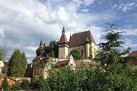
Côté ouest du triangle : Les montagnes du côté ouest des Carpates (Monts Apuseni) ne sont pas majestueuses (altitude maximale : 1849 m, alors que la plupart des cîmes de ces montagnes tournent autour de 1200 m). Par contre, les Monts Apuseni sont pittoresques de par leurs nombreuses caractéristiques karstiques (dolines, ouvalas, ponors, gorges, lapiés, avens, vallées sèches, pertes et résurgences etc.) ou bien à cause de leurs villages avec des maisons traditionnelles éparpillés sur les versants. A remarquer que par des endroits la nature est très sauvage et que, si vous n'êtes pas des pros de la montagne, il vaut mieux ne pas s'aventurer sur les trajets les plus difficils, surtout s'il pleut (valable pour les autres branches des Carpates aussi!!). Afin de se rendre de ce côté-ci des Carpates, il vaut mieux choisir l'aéroport de Cluj-Napoca (il y a de nombreux vols réguliers de Paris-Beauvais). Pour plus d'infos (cartes etc.) il faut voir l'office de tourisme de Cluj-Napoca ou bien quelques agences de tourisme de la ville. Voir aussi la discussion Randonnée de quatre jours en Transylvanie.
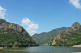
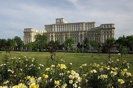
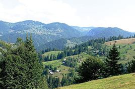
Côté sud du triangle : Si vous voulez monter à plus de 2000 m, il faut joindre la ville de Sibiu (au sud de la Transylvanie, à 163 km de Cluj-Napoca et à 282 km de Bucarest) et faire des randonnées dans la chaîne qui forme le côté sud du triangle. A partir de cette ville vous allez pouvoir monter directement dans le Massif de Fagaras, le plus imposant de la Roumanie (la plupart des sommets de plus de 2500 m de la Roumanie se trouvent dans ce massif). Plus à l'ouest de ce massif, mais toujours dans la même chaîne, vous allez trouver le Massif Retezat qui abrite le Parc National Retezat (paysage grandiose, plus de 80 lacs glaciaires etc etc) et dont le plus haut sommet atteint 2509 m. Afin de monter dans le massif Retezat, il vaut mieux joindre la ville de Petrosani (au sud-ouest de la Transylvanie, à 231 km de Cluj-Napoca et à 343 km de Bucarest). Plus à l'ouest encore, il y a le Massif Parâng (2000 à 2518 m), un peu moins visité que les deux autres. En fin, à l'est du Massif Fagaras il y a le Massif Bucegi (le plus haut sommet : 2505 m) qui est le massif le plus visité de tous les Carpats roumains. Afin de monter dans ce massif il faut se rendre dans la ville de Brasov (au sud-est de la Transylvanie, à 264 km de Cluj-Napoca et à 161 km de Bucarest). A remarquer dans tous ces massifs la présence de l'ours qui, notamment dans le massif de Bucegi, commence à s'habituer à la présence de l'homme, tout en demeurant dangereux. Pour plus d'infos, voir les offices de tourisme de Sibiu et de Brasov ou bien des agences de tourisme.
Côté est du triangle : ce côté des Carpates, dont l'altitude dépasse rarement les 2000 m (plus haut sommet : 2303 m), est le plus diversifié de point de vue morphologique et topographique. D'abord, ces montagnes (disposées en gros en trois chaînes parallèles allant de nord-ouest au sud-est) sont très fragmentées (nombreuses vallées) et on y trouve un peu de tout : des volcans inactifs (surtout dans la chaîne de l'ouest), des calcaires et donc des karst (au sud-est), des roches sédimentaires (dans la chaîne de l'est) et des roches dures (surtout dans la chaîne située au centre). Compte tenu de la grande diversité des roches, l'érosion s'est faite différemment dans chaqu'une de ces trois grandes chaînes. L'ours y est présent aussi. Afin de se rendre dans la moitié nord et ouest de ces montagnes, il vaut mieux choisir l'aéroport de Cluj-Napoca. Pour visiter le sud-est, il faut choisir Bucarest.
Randonner dans les Carpates est faisable par tous niveaux de randonneurs mais il faut quand même se documenter avant et obtenir les meilleures cartes topo possibles. Voici mon blog réalisé après un séjour cet été en Roumanie! Bucarest est accessible justement par de nombreuses compagnies low cost et régulières et est a seulement 3h en voiture du massif de Piatra Craiului d’ou de nombreuses randos sont possibles!
Je compte aller randonner dans les Carpates quelques jours en automne (à partir du 20 octobre). Quelles secteur à conseiller, sachant: -équipement léger (pas…
Je me permets d'envoyer ce message dans le but d'obtenir des informations sur la randonnée dans les Tatras Polonaises et Slovaques: les refuges sont-ils…
Avec une amie nous pensons partir en Roumanie (fin juillet) Nous envisageons une randonnée dans les Carpates. Nous pourrions nous lancer dans un itinéraire…
Histoire de m'occuper un peu cet hiver, je cherche une petite rando en raquettes. Et pourquoi pas dans les Carpates Roumaine où je m'étais déjà bien documenté…
Hi,
We’re planning to do the 4-day trek from Mestia to Ushguli without an agency. The descriptions mention that there are accommodations at each stop, but we can’t find any details about them. Has anyone got info or feedback on this route?
We're planning to trek in Peru and Bolivia and would love to find some local agencies.
If you know any, could you share details on prices and, of course, the names of the agencies?
Which trek would you recommend?
Elocine
Je pars en autonomie totale sur un trek au Maroc (10jrs) Imilchil - Aghbalou.
Trouve t-on des cartouches gaz à vis (Coleman, Primus) à Marrakech (adresse) ou villages entre Imilchil - Aghbalou ?
Si non , trouve-t-on des cartouches Butagaz pour camping-gaz (petit volume 230 gr ...)
Merci d' avance pour vos réponses
Hello, I’d like to embark on a little trip in my home country, Switzerland. I’ll start walking from La Cure, heading toward Le Noirmont first, then I’ll improvise my route—but it’ll probably follow the French border... at least as far as Lac de Joux.
I’ll decide day by day how much farther to go after that. My goal is to stay in nature as much as possible, wander around for as long as I can, and restock food in villages or towns along the way.
I’m thinking of mostly camping, but we’ll see if I end up in a hotel or another campsite depending on my route.
I’d love to reach La Chaux-de-Fonds on foot... maybe even Delémont.
The whole thing should take about a week, give or take.
I’ll be bringing my dog, and I’m preparing for this as soon as I’m ready.
Any tips to make sure everything goes smoothly for us? Things I should know—or avoid? What about shepherds with their flocks of sheep? And isn’t hunting season open right now?
I’m not sure if what I’m planning is even doable, which is why I’m asking around.
This’ll be my first time doing something like this—wandering in nature *and* with a dog. I’m really excited for this adventure... and I need it. Thanks!
We’re really keen on ecosystems and want to hike in "natural" ancient forests—not planted woods or areas heavily degraded by human activity. Travel guides (like Lonely Planet) don’t provide much info on this. Could you point us to the most interesting spots?
Thanks in advance for your tips.
We wish you happy holidays and a fantastic 2026, full of discoveries!
Claire and Albert
Hi, this might not be the right section, but I’d like to know if it’s possible to start mountaineering with another person without necessarily hiring a guide. We’ve done quite a bit of hiking but not mountaineering—we’ll just do a half-day glacier course. After that, we were thinking of starting with La Grande Motte and the Pointe de la Traversière, which were recommended to us. Honestly, for things like roping up and knots, I’ll learn at home with lots of videos and a book.
Jaimerais savoir si quelqu'un aurait fait des treks sur le Ruwenzori et combien ça coute en moyenne, les infrastructures, les paysages la sécurité sur les lieux, merci beaucoup. J'attends avec impatience vos réponses.
We’re leaving in 9 days for a two-week trip to Madeira, mainly to hike.
From my research, I’ve found that since last year, access to most trails—and systematically for the most popular ones—is now paid. You have to pay an access fee of 4.50 € per person per classified hike in 2026, and even 10.50 € for the most iconic hike: Pico Arieiro to Pico Ruivo. When paying, you also have to choose a day and a 30-minute time slot for your start time. Of course, this reservation is neither changeable nor refundable, even if the weather that day is terrible.
Personally, given the massive influx of tourists to the island in recent years, I don’t mind paying a fee to help maintain the trails. Similarly, setting a limit on the number of people who can hike them per day is certainly preferable to preserve this priceless heritage.
However, what’s much less fair is that in reality, most of the available spots are reserved: 1/ for Madeira residents (which is normal); 2/ for "economic operators" (meaning local tour operators). For example, if you’re a non-resident (independent tourist), no booking is possible for the Pico Arieiro hike for an early morning start before September! So, unfortunately, we’ll have to skip this hike.
It’s the same issue for Ponta de São Lourenço, the 25 Fontes, Pico Ruivo... in short, all the most popular hikes. Oh well, we’ll skip those too!
So my question is: which hikes do you recommend where we won’t face the huge crowds that the others get? And where we can book the day before for the next day, taking the weather into account?
Finally, a quick accommodation question: we’ve booked the first week in Funchal, but I haven’t decided yet for the second week. Do you have any advice on where to stay in the south or north, preferably avoiding overly concrete-heavy and touristy spots?
I’m reposting about the logistics for Samaria Gorge.
I’d love to get recent info, especially about whether it’s possible to park my car in Omalos, do the hike, and then catch a bus back to my vehicle.
In theory, it’s doable, but when you check the KTEL website, there aren’t any feasible schedules listed. If anyone has recently organized this with reliable, verified details, I’d really appreciate it. Thanks in advance!
Hi there,
We’re flying from Montreal to Lyon this August to go hiking in the French Alps. We’ve rented a car and will be staying at campgrounds. We’re planning to do day hikes and want to stay a few days in one spot, do a few hikes, then move on to our next camping spot. Could you share your favorite spots or any recommendations for places to spend a few days with great hikes?
A few details:
We arrive in early August and leave in early September.
We’re looking for day hikes (or shorter), moderate difficulty, with a cumulative elevation gain of no more than 1000m, and of course, beautiful scenery!
We’d prefer not to drive too much—maybe it’s best not to head too far south and deal with unnecessary heat?
Along the same lines, if you know of any great campgrounds where we can start our hike directly without needing the car, we’d love to hear your suggestions!
Bonjour
Souhaitant faire de la randonnée sur cette île, je voudrais d'abord savoir quelle serait la période la plus favorable sachant que j'avais passé quelques jours en novembre 2018 pas pour cette activité mais plus pour une simple découverte de l'île et le temps n'était pas top notamment en montagne. Donc peut on choisir une organisation en étoile sachant que je louerai un véhicule avec éventuellement 2 points d'hébergement.
Je n'envisage pas d'intégrer une structure mais de partir à 2 et de s'organiser sauf si vous me conseillez une agence locale ou un guide local. Enfin même si je compte me procurer les différents supports, carte et topo guide plus gps je vous remercie de bien vouloir me communiquer les randos à faire en priorité
Merci beaucoup pour vos informations
I’m planning to do the Mercantour crossing following the Randoxygène route in mid-July.
I’m used to hiking in the mountains, but I sometimes get vertigo, for example on ridges with drops on both sides. I wanted to check if there are any T4 or T3-T4 sections and find out if there are any very exposed passages—and if so, where—so I can plan an alternative route.
Can anyone give me some info on this?
Thanks!
I’m planning a trip around Cap Corse and the AGRIATES in 2026, from May 8th to 15th (there are still 2 spots left, by the way! Just DM me if you're interested).
I’d love to know which hikes are worth prioritizing in the AGRIATES. We’ll be staying in SALECCIA for two days as our base—what should we focus on from there?
A round trip to IGNHU beach? Any other suggestions?
For Ostricano, I think it’s too far for a round trip...
Thanks for your tips!
Have a great day,
Anie, Toulouse
I’d like to get some info about the GR10 Pyrenees traverse. I need help planning the daily stages and accommodations—my wife isn’t an experienced hiker but walks a lot, so I’d like to schedule shorter walking days and thus a longer overall trip in terms of number of days.
Could anyone give me some help and advice?
Best regards,
New to this forum, I’m planning a pretty big project for 2028.
I’m heading to Nepal to do a trek from Kathmandu all the way to Everest Base Camp (a cool 5,300 m 😄).
This trek is a bit special because even though I’ll be part of a group, I’m going solo (so far, no problem—I’m used to it). But it’s my first real trek, and it’s also a humanitarian one: once I reach base camp, I’ll stay an extra week to help clean up the waste left by tens of thousands of climbers! Since I’m originally from South America, from two countries that share the Andes, I have a deep respect for mountains—they fascinate me. So Everest… it’s kind of the trip of a lifetime!
So, a little question for those who’ve done treks to Everest before… any tips for good mental preparation (I’m already working on the physical side)?
Hi there, I’m planning the Annapurna Circuit for March 2027 and I’m looking for a local agency with a local guide—preferably French-speaking—to arrange this trek for us. Any suggestions? Thanks
Hello!
We’re spending a few days in Toraja country at the end of May. We’d love to do a day trek—taking our time—on a route that’s stunning in terms of scenery, but not a level 5 in difficulty!
Any suggestions you can share, please?
Thanks in advance
I’d like to do the Mare a Mare Sud in May over 4 days. I’ve found quite a few places to stay along the route, but I’m stuck on the start and finish.
I’ll be arriving by plane on Sunday evening and would like to start pretty early on Monday morning. Ideally, accommodation right at the trailhead (Alzu di Gallina) would be amazing, but I can’t find anything. Any tips?
Also, for the transfer from Figari Airport to Porto Vecchio or Alzu di Gallina?
At the end, I’d like to pick up a rental car—any advice on that too?
I’m traveling solo by plane to Catania in May and plan to hike the northern side of Etna, starting from Linguaglossa where I’ll arrive by bus. After that, I’d love some info on how to get up to Piano Provenzana (shuttles or hitchhiking), since it seems there’s no public transport except in the summer. Can you sleep there in a free or cheap refuge, or camp? And how far up can you go without having to hire a guide? Thanks in advance. Bernard.
Bonjour a tous,
je pars en voyage au Maroc en aout et nous allons commencer par nous arrêter a Chefchaouen(nous sommes en voiture).
Ma question: quelqu'un peut il m'indiquer un itinéraire de rando en boucle d'entre 5 et 7 jours aux départ de Chefchaouen dans le parc de Talassemtane passant si possible par le pont de dieux?Ou un guide papier qui en reunis quelques uns?
Nous privilégions le camping sauvage et les gites.
Merci d'avance
Hi there, for those who’ve been recently—is it possible to find other solo travelers in March on the island to share transport or room costs? It doesn’t seem easy to travel on a budget.
If you have any recommendations for simple lodgings or places with dorms, I’d love to hear them.
For those who’ve done multi-day treks while moving around: do you need to bring your own sleeping bag? I’d love to hear about itineraries you’ve done without a guide, just with a map and GPS.
Thanks, and have a great day!
Hi everyone!
We’re planning a 15-day road trip to Scotland this summer, specifically to explore and hike on Lewis and Harris—places we’ve never been before. We’ve visited other islands on previous road trips in Scotland (we usually go in April for a week). This would be our first time in Scotland in the summer and for 15 days. We’re looking at late August to early September.
I’m currently drafting the itinerary. We’d be crossing from Ullapool and were thinking of spending 3 nights on Harris and 4 nights on Lewis.
Does that sound balanced to you? Is it better to keep the same accommodation on Harris and the same on Lewis to explore the area? I’d love to hear about any past experiences you’ve had on these islands.
Thanks!
Hi there, I’m trying to leave for 15 days very soon to São Vicente. I’m either looking to join an agency or figure things out on my own to go hiking on one of these islands or both. From what I’ve seen, it’s not easy to organize with local transport, so it gets expensive. Can I use the services of a small local agency? I’m looking for the simplest way to hike for several days. Also, how do you get from São Vicente to São Nicolau? Thanks in advance and have a great day!
Aichatou
I’ve been wanting to do this for several years, and this year’s the one. Next September, I’ll be trekking in Tusheti (Georgia), from Omalo to Shatili.
Of course, I won’t be renting a vehicle that’d just sit unused. No problem getting to Pshaveli, but from there to Omalo, it’s a dirt road (still the case?)
There must be some form of public transport since there are so many guesthouses, and not all travelers come in a 4x4.
If any of you have been to Omalo, could you confirm that these shared transports exist and how often they run?
we’re planning a trip to Yellowstone and hoping to do a three-day backcountry hike if we get a permit.
if any of you have done this before, could you let me know if it’s possible to find water along the way? And if we can transport it, are we allowed to use a stove?
Hello,
I’ll be in Nepal from March 6th to 29th (we’re flying into Kathmandu via Varanasi and leaving via Delhi).
I’m a bit confused about the regulations requiring a guide.
My wife and I (we’re 63 and 64) aren’t experienced trekkers—we’re more used to walking on terrain with very moderate elevation changes. I’m looking for fairly easy hikes, possibly day trips.
Here are my questions:
- Does the Poon Hill trek from Pokhara require a guide, or is it better to go through a local agency? (I’ve seen a lot of them offering 4-day packages)
- I’d like to do a few multi-day hikes around Jomsom (Kagbeni, Mukitinath, Lupra, Marpha)... Do you need a guide for those, and can you find accommodations easily without booking in advance?
Last question—I’m really hesitant to lug around a sleeping bag or down jacket during our 6 weeks in India. Can you easily find these kinds of items at reasonable prices in Pokhara?
Thanks in advance for any tips you can share!
Yann
I’m a 56-year-old man who’s done several treks in Nepal and elsewhere. Also passionate about photography.
I’m looking for one or more people to form a group for a trek in Nepal. The trek is the Annapurna and Manaslu circuit (24 days), including a stop at Tilicho Lake. I’ve got a great itinerary and the local company seems solid. The price is around $1600.
I’ll be in Nepal from April 5 to May 12, 2026, so the trek would need to happen within those dates.