in Entre deux voyages › Carnets de voyage
Langtang – Trekking in the Rain (page 6 of 6)
Discussion started by GeorgesOZ on 2025-09-28
108 replies
This thread has been translated into English.
Langtang – Trek in the Rain
SuperNomad · 2025-11-22 · Message 101 of 109
Hey JM,
To be honest, it’s a bit fuzzy—this was back in 2008. I remember passing by some small lakes, and there was a bakery, if I recall correctly, that sold pastries around that area, I think.
After that, I made my way to Helambu. I must’ve walked for 15 days total.
I was really happy with this trek. I found it less touristy than the classics like the Annapurna Circuit, Annapurna North Base Camp, or the Three Passes Trek in the Everest region starting from Jiri.
How high is the Ganja La Pass? When do you need to turn off to take it, and where does it lead?
Langtang – Trekking in the Rain
Djalma · 2025-11-22 · Message 102 of 109
Hi there!
You must have passed through the Gosainkund lakes and the Laurebina Pass.
On this route, you can find accommodation every day in a village.
The Ganja La Pass is located after Kyanjin Gompa when heading south, and it’s at least 3 days without encountering a single hamlet. On the first day, you’ll need to camp around 4,900 m before crossing the pass at about 5,200 m. Finding the right path isn’t easy, but since 2016, according to FabGreg, the route has been equipped with a fixed rope and a ladder. After the pass, there are still 3 long days of walking, mostly above 4,000 m, with no settlements—so you’ll have to camp at least 2 more nights before reaching the first village, Tharke Gyang, in Helambu.
In the description here, you can see the two routes. The Laurebina Pass route is dotted.
A trek over Ganja La Pass offers wilderness and adventure experiences. If you are trekking during spring, the forest on the trail is colorful and blooming full of rhododendrons. Crossing from Langtang into Helambu via the Ganja La Pass is a serious undertaking requiring good equipment and experience from local guides.
For three or four days there are no facilities and groups with their staff must be fully self-sufficient. Crossing the pass requires technical climbing equipment and trekkers must be skilled and prepared. The trail follows a small valley before reaching the glaciated pass where ropes, crampons, and ice axes may be necessary.
https://www.acethehimalaya.com/trip/langtang-valley-ganja-la-pass-trek/
Langtang – Trek in the Rain
Hypnos · 2026-07-26 · Message 103 of 109
Well, this trip report really didn’t make me want to go back to Nepal :)
Langtang – Trekking in the Rain
GeorgesOZ · 2026-09-07 · Message 104 of 109
Well, this trip report really didn’t make me want to go back to Nepal! :)
I get it! But it’s such a shame—it’s such a captivating country!
It’s true that the recent disaster is enough to discourage a lot of potential visitors. Myself included, I have to admit—well, maybe less so for me (I’ve always been a bit of a daredevil) than for Y, my partner—and I totally understand her!
Having done the trek I describe above just a year ago, I’m naturally glued to any news about this disaster. I’m relieved every time I hear someone’s been rescued from the rubble, even now, a good ten days later, but my heart aches thinking about all the victims.
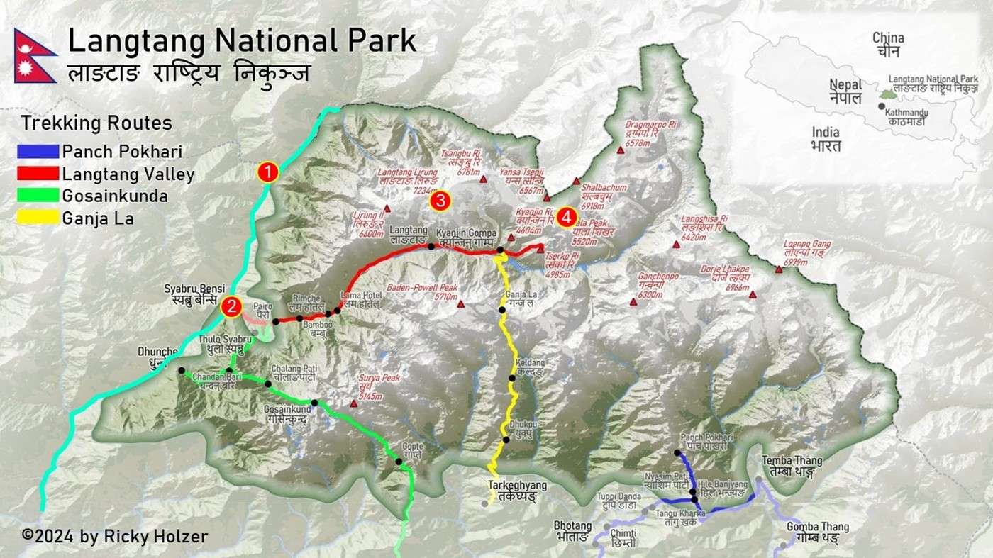
I checked the map. The Langtang Trek is marked in red, starting from Syapru Besi (Point 2), along the Langtang River, which is deeply carved into the foothills of the Langtang massif. The highest point, Langtang Lirung, is at 7,234 meters (Point 3). I’d hoped to see it from Kyanjing Ri (Point 4), which is 4,604 meters high—I only made it to 4,400 meters—but the weather in mid-September was still overcast...
I marked the Trishuli River in blue on this first JPEG.
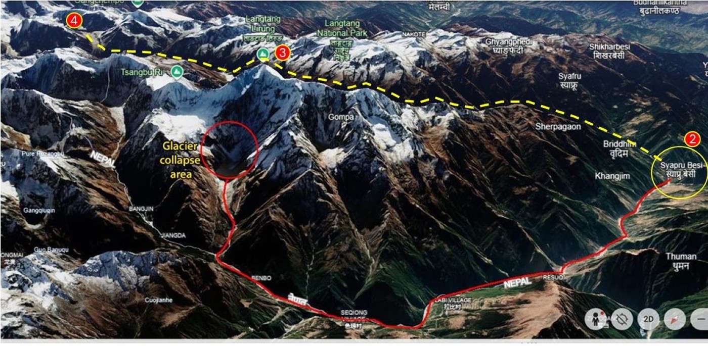
The second JPEG shows the Langtang massif in 3D, viewed from the northwest. The Langtang River—and thus the trek route—is behind the ridge; I’ve highlighted it in yellow. The cause of the disaster was marked (not by me) on the northwest side of the massif. Point 1 indicates the Tibet-Nepal border post, which was completely devastated.
Y and I had a little taste of the dangers you face in these mountains. We had to cross a few landslide zones, and one of them was really risky—the river was just a few dozen meters below with nothing to grab onto if you slipped!
Summer and rising temperatures in Nepal coincide with the monsoon season. It’s a really bad combination....
Langtang – Trek in the Rain
Djalma · 2026-09-07 · Message 105 of 109
I’ve lost touch with Pasang, a Nepali woman from Langtang who used to live in Toulouse and had an account here on VF. She was married to a Frenchman from Toulouse, and I did a long trek in Langtang with him, including the Tamang trail that passes through the Rasuwa Gadi border post, which was swept away by the mudslide. Back then, her brother was our guide...
A little downstream is the village of Timure, where we stayed with Pasang’s close relatives (uncle, aunt, cousins). That village was completely wiped off the map, just like its neighbor Thuman...
West of Syabru Besi, the beautiful, typical Tamang village of Gatlang, perched a bit higher up, was spared...
Really bad luck because in 2015, her home village near Langtang—Thulo Syabru—was destroyed by the earthquake, and she had already lost family members.
Langtang – Trekking in the Rain
GeorgesOZ · 2026-09-08 · Message 106 of 109
I’ve lost touch with Pasang, a Nepali woman from Langtang who used to live in Toulouse and had an account here on VF. She was married to a Frenchman from Toulouse, with whom I’d done a long trek in Langtang, including the Tamang trail that passes through the Rasuwa Gadi border post, which was swept away by the mudslide. Back then, her brother had been our guide...
A little downstream is the village of Timure, where we’d stayed with Pasang’s relatives (uncle, aunt, cousins). That village was completely wiped off the map, just like its neighbor Thuman...
West of Syabru Besi, the beautiful, typical Tamang village of Gatlang, slightly elevated, was spared...
Really tough luck because in 2015, her home village near Langtang, Thulo Syabru, was destroyed by the earthquake, and she’d already lost family members.
My heart aches thinking about all the victims... I feel for you.
I got in touch with the guide and porter who accompanied us in Langtang last September. Fortunately, they’re both safe and sound.
Langtang – Trek in the Rain
HimalGuide · 2026-09-08 · Message 107 of 109
Unlike the 2015 earthquake, this time the affected villages and towns aren’t in the Langtang region or heading toward the Langtang Khola (river) valley. They’re mostly along other rivers, particularly the Bhote Koshi and Trishuli, and especially in downstream areas like Betrawati, Timure, and the village of Trishuli.
On the classic Langtang trek, the only village affected is Syabrubesi.
Langtang – Trekking in the Rain
GeorgesOZ · 2026-09-08 · Message 108 of 109
Unlike the 2015 earthquake, this time the affected villages and municipalities are not located in the Langtang region or toward the Langtang Khola (river) valley. They’re mostly along other rivers, particularly the Bhote Koshi and Trishuli, and especially in downstream areas like Betrawati, Timure, and the village of Trishuli.
On the classic Langtang circuit, the only village affected is Syabrubesi.
Yes, of course—the disaster started on the northwest side of the Langtang Lirung massif, so everything rushed down along the Trishuli and spared the Langtang River valley, which runs along the southeast side of the massif. Given the massive force of the flood, I wonder if there might’ve been some partial backflow upstream along the Langtang River from Syapru Besi (where the Langtang meets the Trishuli). But there were (are?) very few homes on that side of Syapru Besi, at least for several kilometers as far as I remember.
What happened on one side of the massif could just as easily happen on the other—how can you predict it?... Personally, I wouldn’t risk it; last year was enough for me!
I don’t want to scare people unnecessarily or for fun. There are risks you can’t ignore.
Langtang – Trekking in the Rain
Djalma · 2026-09-08 · Message 109 of 109
Thuman and Timure, and higher up, the Rasuwa Gadi border post, are on the route known as the Tamang Heritage Trail. Starting from Syabrubesi toward Gatlang / Tatopani / Nagthali / Thuman / Timure...