Bonsoir à vous,
Mi avril, je pars 10 jours au maroc (marrakech).
Je cherche a partir marcher 4 jours dans l'atlas et si possible sans guide avec nuit en gite.
Ma premiere idee était de faire le m'goun .... mais a cette periode, n'y auras t'il pas trop de neige?
Est possible? connaissez vous d'autres randos en montage dans le coin?.......a oui, j'habite en haute savoie, et j'ai bien l'habitude de grosses randos....
Merci pour vos avis ;-)
bonjour,
Pour ce qui est du M'goun c'est un sommet qui dépasse 4000 m et donc le risque de trouver la neige en avril existe toujours mais sachez qu'il y a moins de chance de trouver beaucoup de neige à cette période que lors de l'hiver. A mon avis Avril/mai est la meilleure période pour faire la vallée heureuse avec ou sans ascension du M'goun.
Sinon puisque tu sera à Marrakech tu peux opter pour Imlil (à 66 km via tahnaout et asni) et à partir de là-bas y a un nombre incalculable de possibilités de randos : faire le toubkal, ouanoukrim ou le tazaghart (tous dépassant ou avoisinant les 4000 m) y a aussi le lac ifni qui est magnifique. A Imlil y beaucoup de gites qui peuvent fournir guide et logistique (mulets et cuisiniers).
"Votre maison ne sera pas une ancre, mais un mât" Gibran Khalil Gibran
Oui probablement le Mgoun sera possible. Le plus chouette dans cette region est de faire la descente des gorges de la riviere Mgoun. On peut combiner avec le sommet.
Mais si tu n'as que peu de temps, une rando dans la region d'Imlil, avec l'ascension possible du Toubkal, est plus proche. Moins de temps perdu en transports.
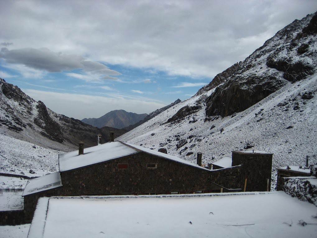
jour 1 Marrakech - Imlil – Aremd et monter au refuge du Toubkal, longue journée…. Jour 2 . Ascension du Toubkal (4167 m) î au refuge Neltner …en partant très tôt le matin !!!
Jour 3 Du refuge Neltner (3207 m). æ au col Aglzia (3500m) î Descente en zig-zag vers les cascades Lépiney et le refuge à Azib Tamsoult (1950m). Total 5h -6h
Jour 4 Montée æ au col de Tizi M’Zik (2370 m) à travers la forêt de genévriers î vers le village d’Aremd (1900 m). Retour à Imlil – Marraekch….longue journée aussi !! arrivée tard le soir à Maarakech…Peut-être faut-il prévoir une nuit suppl. sur place - Aremd ou Imlil ??
C’est serré mais faisable … des journées de 4 à 5 heures de marche selon ton entraînement…avec armes et bagages…. !?! c'est-à-dire vêtements de rechange, sac de couchage….et réchaud à gaz ??
Je ne sais pas si tu trouveras de quoi manger dans les refuges ? il faut bien te renseigner d’abord….je ne le fais qu’avec des guides-porteurs-cuisiniers…..
Attends-toi à avoir de la neige...`!!!
Merci a tous!
Mendouga, tu sais si on peux redescedre sur le lac ifni du toubkal, par un autre sentier que celui de la montée?
Faut vraiment que je me trouve une carte!
Tu sais si les refuges sont tenus par des gardiens ou ils sont "libres"?
Et encore une question, tu sais si marrakech imlil se fait en transport en commun ou taxi?
Merci beaucoup..... et je risque de vous soliciter encore un peu 😛
Dans le désordre:
Il y a des bus qui font Marrakech - Asni , mais après il faut prendre un taxi jusqu'à Imlil. Le jour du marché (le samedi je crois) tu vas trouver plein de transport en commun....grand taxi - camion, etc. Seul tu devrais trouver de quoi remonter jusqu'à Imlil....ou peut-être même des touristes te prennent si tu fais du stop.
A pied en 20-30 min. tu es à Aremd (ou Armed c selon).
De toute façon il n'y a plus de goudron.... c'est le dernier village(à part la petit halte de Sidi Chammarouch: lieu de pèlerinage) avant le refuge du Toubkal .
Pour le lac d'Ifni il est de l'autre côté....je ne crois pas qu'il y ait plusieurs itinéraire pour y arriver....et si tu montes par Neltner....tu vas compter 1 ou 2 jours pour retrouver la vallée.....de l'autre côté....j'y étais, il y a ...8 ou 10 ans et avec guides dans un circuit. Mes souvenirs ne sont plus très frais mais j'ai trouvé ça:
De l'autre côté (comme je te l'ai suggéré) tu va arriver vers les cascades l'Epiney....très jolie région aussi et bon gîte tout neuf à Azib Tamsoult.
En principe les refuges sont gardiennnés: Neltner (Toubkal) à coup sûr....l'autre à Azib Tamesoult je ne sais pas si c'est permanent. Peut-être pas en hiver...car il y a moins de monde qui vient !
Je penses que dans les deux les gardiens (s'il y en a) te feront à manger....mais il vaut mieux se renseigner avant !?!
Bonne préparation !
Pour passer du refuge nelter du toubkal au lac d'Ifni il faut traverser le col ouanams (environ 3500 m d'altitude) et c'est effectivement de l'autre côté par rapport à la voie Imlil refuge Nelter. Du lac d'Ifni vous pouvez rejoindre le village d'Imsouzart pour le retour à Marrakech.
Concernant les refuges du toubkal (3200 m) y en a deux le CAF et les mouflons les deux sont gardés et ouverts toute l'année et proposent des repas sur place. Par contre le refuge lepiney du Tazaghart (3000 m) géré par le CAF n'est pas toujours ouvert il faut demandé au CAF (à Imlil) pour être sûr que le gardien est sur place. Je ne pense pas que le gardien prépare la nourriture. J'y étais y a deux semaines nous avons raméné notre nourriture et on s'est préparé de quoi manger.
Pour aller de Marrakech à Imlil on peut prendre un grand taxi (taxi blanc) à à « charij el beguare » c’est sur Bv Med VI, c’est là-bas qu'on trouve les taxis direction Moulay Ibrahim/Asni/Imlil.
"Votre maison ne sera pas une ancre, mais un mât" Gibran Khalil Gibran
Bonjour Matt 0774,
Je vois que tu es de Cluses.Je lis les réponses que l'on te donne. Effectivement le massif du toubkal est le plus proche de Marrakech, mais bon...Le toubkal ça ressemble beaucoup à la randonnée en haute savoie et je ne parle pas des plus belles.
Gros bémol sur le m'goun en Avril, le mois de mars est le mois le plus arrosé dans le secteur et il peut y avoir de la neige résiduelle sur les pentes du m'goun. J'ai un peu vécu au Maroc, et ai été guide de trekking dans le monde durant 15 ans, je flashe pas sur le secteur toubkal du tout. De gite en gite, à cette époque, j'accepterais les 5 heures de routes vers Boumlane du Dades ou les Aït bougmez. De là y'a moyen de faire 4 jours de trekking dépaysant, soit dans les contreforts de l'Atlas sud, à partir des gites de la vallées de roses, soit dans les AIt Bougmez.
Bon voyage
Je m'excuse tout d'abord de poster ici puisque c'est un peu Hors Sujet, mais je cherche une réponse à ma question et je me demande si tu peux m'aider, c'est un propos d'une visa Schengen .. Voilà : http://voyageforum.com/v.f?post=6407510;#6407510
Merci d'avance en tout cas
tu te fais déposer à l'entrée des Ait Bou Oulli : de MRK, aller à Azilal (au passage, pas loin, y a les cascades d'Ouzoud) puis taxi pour Ait Mhamed et là taxi collectif direction Abachkou (vallée des Ait Bou Oulli) et juste à l'arrivée au souq des Ait bou Oulli, il y a un bon gîte. Tu peux aussi prendre un taxi direction Tabant (vallée des Ait Bou Guemmaz) et te faire à l'entrée des Bou Guemmaz (sommet d'une côte) et descendre par la piste vers les Ait Bou Oulli.
jour 1 : tizi n'tirghist (gravures au col, près de la cabane du gardien) puis descente sur Tarbat n'Tirsal : gîte
jour 2 : balcon du Rhat (peut y avoir de la neige) chemin bien tracé, vues superbes, gîte à Imzayn (ou plutôt le douar en dessous)
si trop de neige (peu probable), col plein ouet de Tarbat descente dans la vallée et remonter cet oued, puis un col pour plonger sur Tizi n'Wawal et là, à gauche on retrouve Imazayn.
jour 3 : plein sud vers Tissili et Ait Ali n'Ito (gîte de qualité) ou même si tu as la pêche, Magdaz (nombreux gîtes)
jour 4 : visite de magdaz: village hérissé d'igherms (sorte de kasbahs berbères); puis si en forme, un col à 2450 WSW du village pour aller à Tagoukht puis plein nord pour Ifoulou où on retrouve la Tessaout et pas très loin souk et goudron, donc gîte et taxis pour Demnate, puis MRK
Itinéraire peu fréquenté, un des plus beaux du Maroc à mon avis, varié : gorge dans les schistes, terres rouges, villages de terre, de grès ou de schistes, des panoramas inoubliables, des zones d'alpage, des zones de cultures...
Compter une journée pour atteindre le point de départ, un peu moins pour le retour.
Pas de ravitaillement possible pendant les 3 premiers jours, un espoir le 4ème (sardines, VacheQuiRit) sauf le pain que les gîtes peuvent fournir et les repas du soir (mais ne pas arriver trop tard). Pas de résa possible (sauf à Ait Ali n'Ito)
Ca va ?
me contacter si questions, je répondrai en privé
Bye
Philippe
Merci a tous!
...mon temps aloué a mon "trek (grand mot)" fond comme neige au soleil.... de 4 jours, je passe a 2..... :(
Alors a votre avis:
J'arrive a marrakech mercredi 7h30
départ pour imlil, aller jusqu'au refuge des mouflons.
Jeudi: depart du refuge, mont toubkal, lac d'ifni et redescente sur ihilene pour la nuit
vendredi: depart pour marrakech...
Voila mon idée.... mais je n'ai aucune idée du temps passé dans les transports ( surtout pour faire ihilene( ou ville d'a cote) marrakech...c'est peut-etre meme pas possible....
Qu'en pensez vous? je compte sur vos bons tuyaux, ou autres bonnes idées.....
Pourles transport et le gardiennage des refuges je crois qu'on t'a répondu. Pour le circuit que tu veux faire.....il me semble bien prétentieux....surtout que tu ne sais pas s'il y aura de la neige ou non.....Ascension + col+ redescendre....ets à mon avis impossible ! Par contre si tu veux faire un circuit - depuis le refuge - après l'ascension (qui est déjà une bonne journée !) tu peux passer le col (à 3500m aussi !) et descendre sur l'Azib Tamesoult - passer la nuit et remonter par le Mzik vers Aremd et imlil ...et retour sur Marrakech tu ne verras pas le lac d'Ifni, c'est certainement moins long !
Sinon reviens une fois pour 4 ou5 jours faire de la rando !! les montagnes ne partent pas :-))
Bonjour,
Je ne connais les conditions sur le Toubkal en ce moment (mois le plus pluvieux et donc neigeux au Maroc)… Entre les transports et ton itinéraire, ça ressemble à une marche forcée…Un détour par le lac d’Imlil, je ne crois pas que ce soit très intéressant.
Je suis partisante du marcher « agréable » quel que soit le niveau du trek ou de la rando (il faut que ce soit beau, quand je me tappe des journées longue c'est que ça vaut le coup), alors déjà le Toubkal, ça ne m’emballe pas. Mais ça chacun ses gouts et objectifs. En deux jours de Marrakech, j’irai dans le secteur mais pas au Toubkal (c’est comme en France). Le secteur d’Ouirgane étant un petit paradis à 60 km de Marrakech, propice à la rando mais ignoré des randonneurs, personnellement je ferais Imlil-Ouirgane en deux jours magnifiques, sans 4 000, mais au Maroc, un petit voyage à pied.Par le col de Tizi M’zzik, la vallée de l’Azzaden , une nuit en gîte au village de Tizi Oussem… Voilà.
je suis du même avis que découvreuse : dans la précipitation, on ne vit pas vraiment les choses; ce qui doit être du plaisir tourne au marathon.
tu reviendras surement un peu plus tard, avec suffisamment de temps.
Bonjour , pour la carte du Toubkal je l'avais trouvée à l'Hôtel Ali à Marrakech mais en attendant elles sont sur mon blog , j'ai pas terminé de les mettre toutes en ligne mais ça devrait déjà te dépanner avant d'acheter la version papier sur place 🙂
salut Matthieu, je suis d Agadir je me prépare la semaine prochaine pour un voyage d aventure comme le tien , si tu veux que je te fasse compagnie et qu on y ira ensemble fais moi signe , merci .
Le secteur d’Ouirgane étant un petit paradis à 60 km de Marrakech, propice à la rando mais ignoré des randonneurs, personnellement je ferais Imlil-Ouirgane en deux jours magnifiques, sans 4 000, mais au Maroc, un petit voyage à pied.Par le col de Tizi M’zzik, la vallée de l’Azzaden , une nuit en gîte au village de Tizi Oussem… Voilà.
Je trouve d'ailleurs étonnant que toutes les attentions se concentrent autour de la vallée de l'Ourika pour les alentours de Marrakech alors que la vallée de Ouirgane est autrement plus belle.
Quoique que c'est mieux ainsi, moins fréquenté du coup...
Merci pour vos infos,
Je vais suivre vos conseilles! Ourigane-imlil....et plus ci affinité
Par contre, je ne trouve pas d'adresse, rien sur un ou des gites a tizi oussem,
T'aurais des infos, un nom....
Encore merci!
Merci pour vos infos,
Je vais suivre vos conseilles! Ourigane-imlil....et plus ci affinité
Par contre, je ne trouve pas d'adresse, rien sur un ou des gites a tizi oussem,
T'aurais des infos, un nom....
Encore merci!
Bonjour Matt 0774
J’ai écrit le post trop vite au niveau de l’itinéraire .
Jour 1 : Imlil - Tizi Mzik - Tizi Oussem - Id Aissa, 4/5 heures, il y a un gîte à Id Aissa, dans la vallée de Azzaden, après le passage du Tizi M'zzik. Jour 2: Id Aissa - Tiziane - Azerfsane-Tassa Ouirgane - Ouirgane. Hébergements à Ouirgane, en hauteur ou dans la bourgade.
Bonne rando
On va voyager au maroc le mois d’avril pour faire un trek. On a 10 jours. On est habitués à faire la rando, ski rando et un peu d’alpinisme. On est en bonne…
Je souhaite organiser un trek de 7 jours (disons entre 6 et 8 jours) dans le haut Atlas en Avril 2019, sans guide (pour des raisons budgétaires) et en…
Nous sommes une famille de 2 adultes + 2 enfants de 7 et 10 ans, et nous avons envie d'aller randonner dans l'Atlas la 2ème quinzaine d'avril (Haut? Moyen?…
Avec un ami, nous envisageons un petit séjour à Marrakech en avril (4 jours), j'aimerai randonner (peut être dans la vallée de l'Ourika), rando facile à…
Bonjour,
Nous souhaitons faire le trek de 4 jours reliant Mestia à Ushguli sans agence. Il est précisé dans les descriptifs qu'il existe des hébergement à chaque étape, mais on ne trouve pas d'info sur ces hébergements. Quelqu'un a-t-il des infos et un avis sur ce parcours?
We're planning to trek in Peru and Bolivia and would love to find some local agencies.
If you know any, could you share details on prices and, of course, the names of the agencies?
Which trek would you recommend?
Elocine
Je pars en autonomie totale sur un trek au Maroc (10jrs) Imilchil - Aghbalou.
Trouve t-on des cartouches gaz à vis (Coleman, Primus) à Marrakech (adresse) ou villages entre Imilchil - Aghbalou ?
Si non , trouve-t-on des cartouches Butagaz pour camping-gaz (petit volume 230 gr ...)
Merci d' avance pour vos réponses
Hello, I’d like to embark on a little trip in my home country, Switzerland. I’ll start walking from La Cure, heading toward Le Noirmont first, then I’ll improvise my route—but it’ll probably follow the French border... at least as far as Lac de Joux.
I’ll decide day by day how much farther to go after that. My goal is to stay in nature as much as possible, wander around for as long as I can, and restock food in villages or towns along the way.
I’m thinking of mostly camping, but we’ll see if I end up in a hotel or another campsite depending on my route.
I’d love to reach La Chaux-de-Fonds on foot... maybe even Delémont.
The whole thing should take about a week, give or take.
I’ll be bringing my dog, and I’m preparing for this as soon as I’m ready.
Any tips to make sure everything goes smoothly for us? Things I should know—or avoid? What about shepherds with their flocks of sheep? And isn’t hunting season open right now?
I’m not sure if what I’m planning is even doable, which is why I’m asking around.
This’ll be my first time doing something like this—wandering in nature *and* with a dog. I’m really excited for this adventure... and I need it. Thanks!
We’re really keen on ecosystems and want to hike in "natural" ancient forests—not planted woods or areas heavily degraded by human activity. Travel guides (like Lonely Planet) don’t provide much info on this. Could you point us to the most interesting spots?
Thanks in advance for your tips.
We wish you happy holidays and a fantastic 2026, full of discoveries!
Claire and Albert
Hi, this might not be the right section, but I’d like to know if it’s possible to start mountaineering with another person without necessarily hiring a guide. We’ve done quite a bit of hiking but not mountaineering—we’ll just do a half-day glacier course. After that, we were thinking of starting with La Grande Motte and the Pointe de la Traversière, which were recommended to us. Honestly, for things like roping up and knots, I’ll learn at home with lots of videos and a book.
Hi,
I don’t know Switzerland at all and was wondering if Vallée des Joux and especially Dent de Vaulion are packed early in the morning or late in the afternoon in July and September?
If so, do you have any quieter spots to recommend in the area, or in Luxembourg (yes, I know it’s not the same country 😉)?
Thanks a lot!
Jaimerais savoir si quelqu'un aurait fait des treks sur le Ruwenzori et combien ça coute en moyenne, les infrastructures, les paysages la sécurité sur les lieux, merci beaucoup. J'attends avec impatience vos réponses.
We’re leaving in 9 days for a two-week trip to Madeira, mainly to hike.
From my research, I’ve found that since last year, access to most trails—and systematically for the most popular ones—is now paid. You have to pay an access fee of 4.50 € per person per classified hike in 2026, and even 10.50 € for the most iconic hike: Pico Arieiro to Pico Ruivo. When paying, you also have to choose a day and a 30-minute time slot for your start time. Of course, this reservation is neither changeable nor refundable, even if the weather that day is terrible.
Personally, given the massive influx of tourists to the island in recent years, I don’t mind paying a fee to help maintain the trails. Similarly, setting a limit on the number of people who can hike them per day is certainly preferable to preserve this priceless heritage.
However, what’s much less fair is that in reality, most of the available spots are reserved: 1/ for Madeira residents (which is normal); 2/ for "economic operators" (meaning local tour operators). For example, if you’re a non-resident (independent tourist), no booking is possible for the Pico Arieiro hike for an early morning start before September! So, unfortunately, we’ll have to skip this hike.
It’s the same issue for Ponta de São Lourenço, the 25 Fontes, Pico Ruivo... in short, all the most popular hikes. Oh well, we’ll skip those too!
So my question is: which hikes do you recommend where we won’t face the huge crowds that the others get? And where we can book the day before for the next day, taking the weather into account?
Finally, a quick accommodation question: we’ve booked the first week in Funchal, but I haven’t decided yet for the second week. Do you have any advice on where to stay in the south or north, preferably avoiding overly concrete-heavy and touristy spots?
I’m reposting about the logistics for Samaria Gorge.
I’d love to get recent info, especially about whether it’s possible to park my car in Omalos, do the hike, and then catch a bus back to my vehicle.
In theory, it’s doable, but when you check the KTEL website, there aren’t any feasible schedules listed. If anyone has recently organized this with reliable, verified details, I’d really appreciate it. Thanks in advance!
Hi there,
We’re flying from Montreal to Lyon this August to go hiking in the French Alps. We’ve rented a car and will be staying at campgrounds. We’re planning to do day hikes and want to stay a few days in one spot, do a few hikes, then move on to our next camping spot. Could you share your favorite spots or any recommendations for places to spend a few days with great hikes?
A few details:
We arrive in early August and leave in early September.
We’re looking for day hikes (or shorter), moderate difficulty, with a cumulative elevation gain of no more than 1000m, and of course, beautiful scenery!
We’d prefer not to drive too much—maybe it’s best not to head too far south and deal with unnecessary heat?
Along the same lines, if you know of any great campgrounds where we can start our hike directly without needing the car, we’d love to hear your suggestions!
Bonjour
Souhaitant faire de la randonnée sur cette île, je voudrais d'abord savoir quelle serait la période la plus favorable sachant que j'avais passé quelques jours en novembre 2018 pas pour cette activité mais plus pour une simple découverte de l'île et le temps n'était pas top notamment en montagne. Donc peut on choisir une organisation en étoile sachant que je louerai un véhicule avec éventuellement 2 points d'hébergement.
Je n'envisage pas d'intégrer une structure mais de partir à 2 et de s'organiser sauf si vous me conseillez une agence locale ou un guide local. Enfin même si je compte me procurer les différents supports, carte et topo guide plus gps je vous remercie de bien vouloir me communiquer les randos à faire en priorité
Merci beaucoup pour vos informations
I’m planning to do the Mercantour crossing following the Randoxygène route in mid-July.
I’m used to hiking in the mountains, but I sometimes get vertigo, for example on ridges with drops on both sides. I wanted to check if there are any T4 or T3-T4 sections and find out if there are any very exposed passages—and if so, where—so I can plan an alternative route.
Can anyone give me some info on this?
Thanks!
I’m planning a trip around Cap Corse and the AGRIATES in 2026, from May 8th to 15th (there are still 2 spots left, by the way! Just DM me if you're interested).
I’d love to know which hikes are worth prioritizing in the AGRIATES. We’ll be staying in SALECCIA for two days as our base—what should we focus on from there?
A round trip to IGNHU beach? Any other suggestions?
For Ostricano, I think it’s too far for a round trip...
Thanks for your tips!
Have a great day,
Anie, Toulouse
I’d like to get some info about the GR10 Pyrenees traverse. I need help planning the daily stages and accommodations—my wife isn’t an experienced hiker but walks a lot, so I’d like to schedule shorter walking days and thus a longer overall trip in terms of number of days.
Could anyone give me some help and advice?
Best regards,
New to this forum, I’m planning a pretty big project for 2028.
I’m heading to Nepal to do a trek from Kathmandu all the way to Everest Base Camp (a cool 5,300 m 😄).
This trek is a bit special because even though I’ll be part of a group, I’m going solo (so far, no problem—I’m used to it). But it’s my first real trek, and it’s also a humanitarian one: once I reach base camp, I’ll stay an extra week to help clean up the waste left by tens of thousands of climbers! Since I’m originally from South America, from two countries that share the Andes, I have a deep respect for mountains—they fascinate me. So Everest… it’s kind of the trip of a lifetime!
So, a little question for those who’ve done treks to Everest before… any tips for good mental preparation (I’m already working on the physical side)?
Hi there, I’m planning the Annapurna Circuit for March 2027 and I’m looking for a local agency with a local guide—preferably French-speaking—to arrange this trek for us. Any suggestions? Thanks
Hello!
We’re spending a few days in Toraja country at the end of May. We’d love to do a day trek—taking our time—on a route that’s stunning in terms of scenery, but not a level 5 in difficulty!
Any suggestions you can share, please?
Thanks in advance
I’d like to do the Mare a Mare Sud in May over 4 days. I’ve found quite a few places to stay along the route, but I’m stuck on the start and finish.
I’ll be arriving by plane on Sunday evening and would like to start pretty early on Monday morning. Ideally, accommodation right at the trailhead (Alzu di Gallina) would be amazing, but I can’t find anything. Any tips?
Also, for the transfer from Figari Airport to Porto Vecchio or Alzu di Gallina?
At the end, I’d like to pick up a rental car—any advice on that too?
I’m traveling solo by plane to Catania in May and plan to hike the northern side of Etna, starting from Linguaglossa where I’ll arrive by bus. After that, I’d love some info on how to get up to Piano Provenzana (shuttles or hitchhiking), since it seems there’s no public transport except in the summer. Can you sleep there in a free or cheap refuge, or camp? And how far up can you go without having to hire a guide? Thanks in advance. Bernard.
Bonjour a tous,
je pars en voyage au Maroc en aout et nous allons commencer par nous arrêter a Chefchaouen(nous sommes en voiture).
Ma question: quelqu'un peut il m'indiquer un itinéraire de rando en boucle d'entre 5 et 7 jours aux départ de Chefchaouen dans le parc de Talassemtane passant si possible par le pont de dieux?Ou un guide papier qui en reunis quelques uns?
Nous privilégions le camping sauvage et les gites.
Merci d'avance
Hi there, for those who’ve been recently—is it possible to find other solo travelers in March on the island to share transport or room costs? It doesn’t seem easy to travel on a budget.
If you have any recommendations for simple lodgings or places with dorms, I’d love to hear them.
For those who’ve done multi-day treks while moving around: do you need to bring your own sleeping bag? I’d love to hear about itineraries you’ve done without a guide, just with a map and GPS.
Thanks, and have a great day!
Hi everyone!
We’re planning a 15-day road trip to Scotland this summer, specifically to explore and hike on Lewis and Harris—places we’ve never been before. We’ve visited other islands on previous road trips in Scotland (we usually go in April for a week). This would be our first time in Scotland in the summer and for 15 days. We’re looking at late August to early September.
I’m currently drafting the itinerary. We’d be crossing from Ullapool and were thinking of spending 3 nights on Harris and 4 nights on Lewis.
Does that sound balanced to you? Is it better to keep the same accommodation on Harris and the same on Lewis to explore the area? I’d love to hear about any past experiences you’ve had on these islands.
Thanks!
Hi there, I’m trying to leave for 15 days very soon to São Vicente. I’m either looking to join an agency or figure things out on my own to go hiking on one of these islands or both. From what I’ve seen, it’s not easy to organize with local transport, so it gets expensive. Can I use the services of a small local agency? I’m looking for the simplest way to hike for several days. Also, how do you get from São Vicente to São Nicolau? Thanks in advance and have a great day!
Aichatou
I’ve been wanting to do this for several years, and this year’s the one. Next September, I’ll be trekking in Tusheti (Georgia), from Omalo to Shatili.
Of course, I won’t be renting a vehicle that’d just sit unused. No problem getting to Pshaveli, but from there to Omalo, it’s a dirt road (still the case?)
There must be some form of public transport since there are so many guesthouses, and not all travelers come in a 4x4.
If any of you have been to Omalo, could you confirm that these shared transports exist and how often they run?
we’re planning a trip to Yellowstone and hoping to do a three-day backcountry hike if we get a permit.
if any of you have done this before, could you let me know if it’s possible to find water along the way? And if we can transport it, are we allowed to use a stove?
Hello,
I’ll be in Nepal from March 6th to 29th (we’re flying into Kathmandu via Varanasi and leaving via Delhi).
I’m a bit confused about the regulations requiring a guide.
My wife and I (we’re 63 and 64) aren’t experienced trekkers—we’re more used to walking on terrain with very moderate elevation changes. I’m looking for fairly easy hikes, possibly day trips.
Here are my questions:
- Does the Poon Hill trek from Pokhara require a guide, or is it better to go through a local agency? (I’ve seen a lot of them offering 4-day packages)
- I’d like to do a few multi-day hikes around Jomsom (Kagbeni, Mukitinath, Lupra, Marpha)... Do you need a guide for those, and can you find accommodations easily without booking in advance?
Last question—I’m really hesitant to lug around a sleeping bag or down jacket during our 6 weeks in India. Can you easily find these kinds of items at reasonable prices in Pokhara?
Thanks in advance for any tips you can share!
Yann