bonjour,
j'ai installé les 2 appli mais n'arrive pas à mettre les campings sur osmand ?
android me demande vers quel gps envoyer … le but c'est évidemment de voir en hors ligne.
merci d'avance une fois de plus pour vos suggestions. cdt.
Je viens de tester:
1. Télécharger! Sur le site de archiescamping, j'ai télécharger l'archive de tous les camping d'europe! Ouch.
2. décompresser le fichier zip. Il y a un répertoire GPX exchange xxxx, dans ce répertoire un fichier archies_europe.gpx qu'on va copier dans le répertoire des traces de osmand
3. Chez moi c'est dans carte_SD/Android/data/net.osmand.plus/files/tracks
Ça peut varier suivant la version de osmand, et la localisation de l'application qui peut être aussi dans stockage_principal/Android/data/net.osmand.plus/files/tracks
4. Ouvrir osmand. Menu Paramétrer la carte, puis Fichiers GPX, et activer archies europe (dans mon cas)
Résultat .... monstrueux! Chaque camping est un POI signalé par un rond rouge étoilé. Il y en a ... partout. Peut-être faut-il filtrer.
Si tu veux afficher dans Osmand les campings en France par exemple il faut télécharger gratuitement le fichier de POI des campings Europe/FR archies_europe-f.zip ici
dans le dossier
"GPX eXchange-www.archiescampings.eu vs 01-01-20"
tu prends le fichier "archies_europe-f.gpx".
tu le mets dans le dossier par exemple "download" de ton téléphone.
tu lances Osmand
ensuite menu > Favoris > +
tu cherches le dossier "Download" puis tu sélectionnes le fichier "archies_europe-f.gpx"
ensuite "ok"
Pour voir les campings
dans menu > favoris > à "archies....gpx" appuie sur les 3 points > "afficher sur la carte"
dans le paramétrage de la carte du profil "vélo" il faudra activer "favoris" et sélectionner "archies_europe-f.gpx".
note :
- le fichier donne moins de renseignements que situ achètes l'appli. Tu auras juste la position et le téléphone.
- l'icone de camping est par défaut un petit disque orange au lieu d'une tente.
Attention depuis la dernière version les paramétrages des profils sont indépendants les uns des autres.
Deuxième possibilité, sans passer par archiescamping, qui consiste à utiliser les campings connus par osm. Et ce sont, à peu près, les mêmes:
Dans osmand, menu paramétrer la carte : Sur-couche des points d’intérêt
Sélectionner Rechercher, taper camping et ... cliquer dans Afficher sur carte.
Voilà, ils y sont aussi par ce bias.
Attention, on peut avoir comme surprise un camping désaffecté, loin de tout, tombée de la nuit. Hum.
Si tu veux afficher dans Osmand les campings en France par exemple il faut télécharger gratuitement le fichier de POI des campings Europe/FR archies_europe-f.zip ici
dans le dossier
"GPX eXchange-www.archiescampings.eu vs 01-01-20"
tu prends le fichier "archies_europe-f.gpx".
tu le mets dans le dossier par exemple "download" de ton téléphone.
tu lances Osmand
ensuite menu > Favoris > +
tu cherches le dossier "Download" puis tu sélectionnes le fichier "archies_europe-f.gpx"
ensuite "ok"
Pour voir les campings
dans menu > favoris > à "archies....gpx" appuie sur les 3 points > "afficher sur la carte"
dans le paramétrage de la carte du profil "vélo" il faudra activer "favoris" et sélectionner "archies_europe-f.gpx".
note :
- le fichier donne moins de renseignements que situ achètes l'appli. Tu auras juste la position et le téléphone.
- l'icone de camping est par défaut un petit disque orange au lieu d'une tente.
Attention depuis la dernière version les paramétrages des profils sont indépendants les uns des autres.
Merci beaucoup vfpromeneur, je ne connaissais pas ce raccourci, puissant.
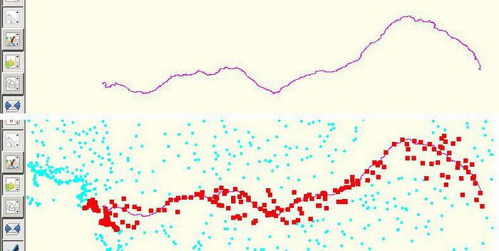
Avec 10.000 POI, la carte est difficile à lire sur un téléphone.
Ma méthode :
1. Dessiner le parcours qu'on souhaite réaliser à vélo et l'exporter en GPX
2. L'ouvrir dans l'application JOSM
3. Downloader et dézipper le fichier pour la France, puis l'ouvrir dans JOSM dans une autre couche
4. Utiliser l'outil lasso pour ne garder que ceux proches du parcours et les insérer dans une nouvelle couche
5. Exporter ce sous-ensemble dans un fichier GPX et l'ouvrir dans son appli smartphone préférée
un grand merci à toi - ta proposition est simple et me va. (testé)
VF est vraiment un forum d''entraide unique ! merci à tous pour vos réponses .
belle année de cyclo. cdt
- les icônes venant d'Archies : disque orange (ou la couleur que tu choisis) avec une étoile au centre
- les icônes Osmand : disque orange avec une tente au centre ( menu > paramétrer la carte > surcouche des points d'intérêt > recherche > camping > afficher sur la carte ).
Perso, je note les problèmes pendant le voyage en incluant les coordonnées GPS, et je fais les modifs dans OSM en rentrant. Plus simple avec un clavier+souris+grand écran.
J'enregistre avec le greffon par exemple un resto qui n'est pas dans osm mais je n'envoie pas la modif à osm via le plugin.
Dans les paramètres du greffon je coche "Modification hors ligne"
Pour enregistrer une modif :
j'appuie à l'endroit où se trouve le resto
un volet s'ouvre
j'appuie sur l'icône représentant un écran couvert d'icônes
j'appuie sur "créer un point d'intérêt" (en cas d'appui sur un poi existant est proposé "modifier un point d'intérêt")
A la fin "enregistrer"
A mon retour avec JOSM j'envoie les modifications :
je vais dans la gestion des greffons
je sélectionne le greffon "osm"
Dans les paramètres du greffon il y a "points d'intérêt/notes enregistrés ... Afficher et gérer ..."
Je complète, je rectifie mes notes et les reporte dans osm via josm les modifs enregistrées
Avec 10.000 POI, la carte est difficile à lire sur un téléphone.
Ma méthode :
1. Dessiner le parcours qu'on souhaite réaliser à vélo et l'exporter en GPX
2. L'ouvrir dans l'application JOSM
3. Downloader et dézipper le fichier pour la France, puis l'ouvrir dans JOSM dans une autre couche
4. Utiliser l'outil lasso pour ne garder que ceux proches du parcours et les insérer dans une nouvelle couche
5. Exporter ce sous-ensemble dans un fichier GPX et l'ouvrir dans son appli smartphone préférée
Illustration pour la Loire à vélo
Tiens il faudra que je teste c'est surement plus simple que la manière que j'utilise avec un modèle dans QGis disons que pour de longues traces c'est bien quand même, mais le camping qui se trouve à 500 m de la zone déterminée sera exclu..
voilà comment ça peut se présenter, il récupère les campings à 10 km de chaque coté de la trace.
Je m'en sers aussi pour des gares etc..
La difficulté est que je n'arrive pas à récuperer les champs d'info complémentaire que l'on voit dans Archies.
Dans locus le tel est bien là mais pas cliquable, mais bon ce n'est pas dramatique
En effet c'est QGis, non je n'ai pas posé de question sur des forums correspondants, de temps en temps j'essaye, mais comme mon objectif premier était d'avoir des campings bien placé à proximité, je m'en contente
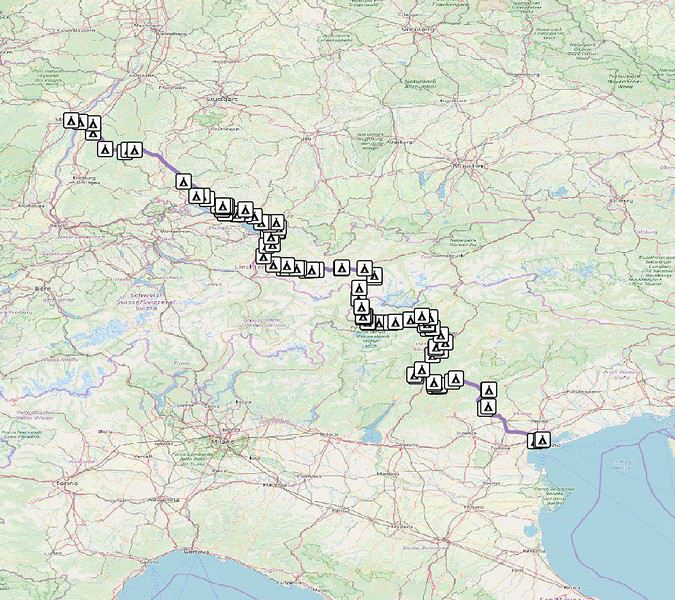
Je sais que ma réponse ne répond pas exactement à la question posée, mais Cycle.travel, cet excellent routeur pour le voyage à vélo, permet de trouver des logements proches de la trace GPX chargée. Les campings qui s'affichent proviennent de la base Archiescamping. Leurs noms et téléphones sont affichés.
La contrainte, c'est d'être connecté à un réseau data.
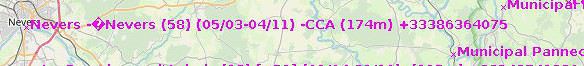
Pouvez vous me dire pourquoi j'obtiens ceci (et non des marqueurs orange) sur josm en chargeant le fichier archie pour la France ?
Après ouverture par File > Open du fichier GPX, clic-droit sur le fichier dans la liste ("Markers from…") puis "Convert to data layer" > OK > Simplify ?
merci pour ces informations. Maintenant j'ai les marqueurs mais quand je clique dessus le marqueur devient orange mais il n'affiche aucune information.
Les points ne contiennent qu'un champ name, dont le contenu est affiché dans la barre à droite, section Layers (si pas visible : Windows > Tags/Memberships).
Dans les applis gratuite (open-source, en tout cas), il y a GpsPrune.
Il existe probablement des applis propriétaires (Garmin etc.) mais je ne connais pas.
Vu la taille du fichier, éviter d'uploader ça sur des sites web type VisuGPX etc.
J'ai téléchargé Osmand sur mon tél (redminote7) avec trace GPX, non pas pour suivre en direct mais simplement pour me retrouver si je me paume. j'ai testé ce…
Mon tél (android9) ne prend pas la version de BRouter. est-ce possible de télécharger une trace GPX de l'ordi sur Osmand tél? le cas échéant, comment faire?…
Voilà un bout de temps que je travaille sur ce projet, et maintenant j'aimerais le partager ici. Il s'agit d'une application web qui vise à aider les voyageurs…
J'utilise Osmand couplé a Brouteur pour préparer mes parcours velo. Par contre je ne sais pas comment générer un Gpx a partir de la proposition de parcours que…
Je souhaite faire Morlaix Brest ( via Roscoff et la littoral V45) nous commencerons à rouler le 16 aout pour 13 jours (avec des pauses visites iles , surf etc..) Est ce qu'il y a beaucoup de circulation à cette époque de l'année car j'ai 2 enfants de11 et 13 ans et on n'aime pas rouler au milieu des voitures (on a déjà fait velomaritime ; Caen - Cherbourg, loire : Orléans- Saumur, Velodyssée : Nantes - Royans, les canaux : nivernais , bourgogne etc ... et il y avait beaucoup de voies réservées aux vélos ce qui n'est pas le cas sur cet itinéraire).
Merci de votre aide si vous avez déjà parcourue cet itinéraire fin aout.
Virginie
Ca y est j'ai mon billet d'avion, départ mi novembre, retour mi-mars.
arrivée santiago et je repars depuis Buenos Aires.
J'ai deja été dans le sud de l'argentine, notamment le parc torres del Paine, et j'ai très envie d'y retourner pour faire le grand W, j'avais fait le petit.
Je souhaite aussi randonner qq foois et pourquoi pas faire un sommet. Je grimpe et je fais occasionnellement de l'alpinisme, donc ce sera avec un guide de toute façon.
Je compte démarrer vers temuco au chili, j'ai dans l'idée d'aller vers les lac, puis prendre la careterra austral.
Je sais pas si je vais aller jusqu'à Ushuaia, parait que cela vaut pas tant que cela la peine, à part pour dire qu'on a été au bout de la terre.
j'ai vu vite fait qu'il y'avait des lac en Argentine.
Je n'ai pas d'itinéraire précis. Mais ce que je souhiaterai, c'est qu'une fois arriver le plus au sud de mon vooayage, faire une mini croisière pour voir des annimaux.
Des conseils pour cela?
qu'avez vous pris comme sac de couchage? un 0 degré suffit?
et ultime question, réchaud à essence ou est-ce que je peux m'en sortir avec mon réchaud gaz?
Cet été nous prévoyons de pédaler sur l'EV 19 qui longe la Meuse de Langres jusqu'à Rotterdam.
Mon questionnement concerne le retour jusqu'à Nantes.
Savez vous quel est le meilleur retour possible? J'en appelle à vos expériences.
Je voyais que Flixbus ne prenait pas les vélos.
En train, je pense que c'est possible avec de multiples petits trains.
On se questionnait aussi sur l'existence d'un bateau qui irait de Rotterdam jusqu'à St Nazaire et qui pourrait charger des passagers avec vélos.
Toutes vos expériences partagées nous seront bien utiles et nous vous en remercions.
Bonne soirée
Hi there,
I’ve been road cycling for several years, and I’m about to switch to gravel in the next few days—I’m waiting for my bike, which should arrive this week.
I’m planning a bikepacking trip in a few weeks along the Véloroute V81, also known as the Vélosud, from Biarritz to Le Barcarès.
Has anyone here already done this route? Any info is welcome, whether it’s about the route itself, gear, or accommodation. I’ll prioritize staying with locals as much as possible. On that note, I just signed up for the brand-new site *Guidon et Couette* ((www.guidon-et-couette.fr)), which offers free accommodation between cyclists across the country, but there’s almost no one listed along my route!
Thanks in advance.
Laurent.
I’m planning to build a new touring bike.
I want to prioritize lightness.
That said, I’m tempted by a suspension fork that could offer some comfort on rougher roads.
The recent appearance of gravel suspension forks on the market might meet my needs—at least on paper.
I’m particularly considering the RockShox Rudy Ultimate XPLR fork.
Unlike MTB forks, its travel is short: either 30 mm or 40 mm.
It weighs 1400 g, which is 400/500 g more than a steel fork.
Any thoughts or real-world feedback on this?
I’m also wondering about the durability of magnesium (lower leg) for long-distance bike touring.
And what’s the impact of skipping the manufacturer-recommended maintenance every 50 and 200 hours? That’s bound to happen on a long trip unless you carry extra gear.
More generally, how reliable are these kinds of forks?
Hi everyone,
I wanted to share with you the incredible feat my friend José, who’s 72 years old, is currently undertaking. He left Auterive near Toulouse on Monday, May 18, 2026, on his non-electric bike, heading for the North Cape in Norway!
You can follow his route on the link below—he’s currently in Sweden:
https://thierry-thomas.travelmap.net/jose-de-toulouse-a-nord-cap-2026
You can zoom in on the map and click on each stopover town to see the photos
I’m making an exception and creating a separate post this time, since it’s all about France. In May, we spent a week in Provence, specifically in the Luberon, exploring the cycling routes *Autour du Luberon à Vélo*, the *Véloroute du Calavon* (part of EuroVelo 8), and the shorter *Les Ocres à Vélo* route. Together, they gave us an amazing journey through rolling hills, vineyards, lavender fields still green in spring, and some of the most stunning landscapes in southern France.
It was, of course, the perched villages that impressed us the most. We visited Gordes, Roussillon, Bonnieux, Lacoste, Lourmarin, Ménerbes, Oppède-le-Vieux, Cucuron, and Lauris. Many of them are among the most beautiful villages in Provence, and it’s hard not to agree with that reputation.
One interesting point is the route of EuroVelo 8 in this part of the region. The official path mainly follows the old railway line of the *Véloroute du Calavon*, which is very comfortable and safe. But in our opinion, cyclists traveling EuroVelo 8 around the Mediterranean would discover even more treasures if the route passed through villages like Bonnieux, Lacoste, or Oppède-le-Vieux.
We were also pleasantly surprised by how safe cycling felt. Most of the route takes small local roads, but traffic is light, drivers are respectful, and road design really takes cyclists into account. It’s one of those places where you can ride peacefully even without separated bike lanes.
Our full story:
Around Luberon by bicycle - the most beautiful villages of Provence
You can also find all our cycling travel stories on the forum:
Cycling Thread - Europe’s most beautiful bike routes
Hi there, we’re a group of 4 cyclists looking to get from Treviso in Italy to Munich with our 4 non-folding bikes. It seems complicated! Are there any solutions? Thanks so much.
hello fellow cycling enthusiasts
here’s a travel journal of the cycling tour through the Rhône-Alpes Auvergne region by Claudio
zouli
it was the plan
http://cbandiera.free.fr/parcours/auvergne-Ralpes/
the trip was completed
story being posted online soon
1100 km in 11 days
beautiful and varied regions
Hi there, we’re planning a Munich to Venice bike trip at the end of June 2026. Getting back from Venice to Toulouse by train with 4 bikes isn’t straightforward. What return options have others who’ve done this trip chosen? Any tips or great deals would be much appreciated. Thanks a bunch! !
Hi everyone,
Happy owner of a Pegasus Estremo bike with a Rohloff hub, which is giving me trouble with the SF11-NCX-FT-E-LITE 700C TS 300/0 fork (serial number TD01329060). It’s starting to show its age, and I’d like to repair it to extend the life of my beloved bike.
The suspension is gone, and there’s an oil leak from the seals.
Does anyone know how to repair it? Where can I find parts that are about fifteen years old? Or where to find an identical replacement fork? Just to clarify, the Magura HS11 brakes are mounted using Firm Tech, meaning they’re on pivots behind the fork, facing the frame.
Hi, I'd like to know if anyone has done this route recently or has reliable info.
Does the track exist, and most importantly, is there sand (for biking)?
Any info is welcome.
Cheers,
diego ambilobe: mangaoka, manondro, ramena
vohemar sambava: masondrono, tanambao
Hi there,
New to bike touring,
I’d love to start with a section of the Via Rhona to explore and share (route to be decided).
Looking forward to exchanging tips!
I’m landing in Madagascar with a buddy before the end of April 2026. We’re planning to bike around for about twenty days or so. We don’t have a specific goal other than exploring the country and meeting the locals.
Ideally, we’d prefer a loop route starting from Antananarivo with a good chunk of it along the coast. On the bike side, we’re used to riding 6 to 8 hours a day, depending on the needs, encounters, and mood 😉 Any feedback or tips from trips around this length?
A big thank you to Lazarou for all the info you share in this forum!
I'm passionate about Morocco, which I cycled through back in 2009.
Last year, my wife and I explored the High Atlas by tandem. Completely smitten, we're heading back in April (Anti Atlas) and May (High and Middle Atlas), still on our tandem.
Do you have any info on the track between Amezri and Ali Ait Nito? Are the river crossings in the Tessaout still there? It's not easy to navigate with a loaded tandem... especially if the river level is high due to this year's heavy snowmelt!
Thanks in advance for any tips you might have, and best wishes for health in this new year!
Claudio specializes in the route of the Savoie lakes
Here are his travels
Between Bornes, Chartreuse, the Savoie foothills, and Dauphiné
Five lakes: Léman, Annecy, Paladru, Aiguebelette, Bourget, not to mention a few ponds along the way
Plenty of accommodation options: camping, hotels, and more...
A lovely route not far from his place
Rural and quite peaceful
A road cycling route created by Serge B...
Tout d'abord... bonne année ! De belles routes à vous en 2017 !
Je voyage depuis quelques années avec un VTT de très bonne qualité mais équipé de freins à disques hydrauliques. Je vis (pédale) avec l'inquiétude d'avoir une panne (fuite, bulle d'air, chaleur qui fait que le liquide...). Mon vélociste me dit qu'il est impossible de les changer pour des V brakes.
Qu'en pensez-vous ? Est-ce que je prends un gros risque à continuer (seule) avec ces freins ? D'avance je vous remercie pour vos bonnes idées.
First post here to share a quick recap of our west-to-east bike trip along Algeria’s coast in January 2025.
It was just the two of us—my partner and I—with French passports and not a word of Arabic. No friends or welcoming hosts in the country.
Under those conditions, we’d strongly advise against going.
Our original plan was to follow the coast from Algiers to Tunis. We ended up cycling from Algiers to Béjaia, then took the train from Béjaia to Annaba (with a stop in Constantine), and finally biked to the border.
We were tailed by police the whole way—whether on our bikes, on the train, or even on foot while exploring towns. On top of that, we couldn’t wild camp and were limited to the few state-approved hotels that accept foreigners. Under those circumstances, connecting with locals was especially tough.
With such an omnipresent and intrusive police presence, we’d definitely recommend against this destination for bike touring. A really sad situation that completely cuts you off from the local population...
We’d been warned, we went to check it out, and we weren’t disappointed!
Hi there,
I’m planning the route to cycle from Lille to Nordkapp with my partner.
Duration: 3 months, from May 1st to July 31st, 2026.
In the attached details below, I need to add some "non-riding" days (rest days, basically).
So I’m looking to "shorten" the trip by taking ferries or trains for some stretches. Which areas could I skip?
Thanks in advance for your great tips.
Have a good evening.
https://www.komoot.com/fr-fr/collection/4023980/-lille-cap-nord-1er-mai-au-31-juillet-2026?ref=collection
I’m planning to bike back from Poland this summer. Does anyone know a way to ship it there without having to take it apart? Otherwise, it’s a real hassle to fine-tune all the settings before departure!
Thanks in advance.
Hi, has anyone recently bought Primus or Butagaz gas, possibly puncture-style, in Dubrovnik or the surrounding area? Same question for Albania... thanks. aichatou
Just a few words about the loop I did by bike in Yunnan.
Entry and exit
I entered China through the Sino-Vietnamese border crossing at Lào Cai / Hekou under the 30-day visa exemption currently available to French nationals and others.
The process was simple and quick. A Chinese police officer even helped me complete my electronic pre-registration at a computer kiosk. I wasn’t aware this formality was required—it’s similar to Thailand’s TM6.
No issues with the bike.
I left the country via the Sino-Laotian border crossing at Mohan / Boten.
The atmosphere was a bit chaotic there, but again, no problems with the bike.
The timing
I visited Yunnan in February 2026.
Weather-wise, at higher altitudes (between 1,500 and 2,000 meters), it was around ten degrees at night and in the mornings, and around twenty degrees at the hottest part of the day.
I had two days of rain, so I took the bus to keep moving. Otherwise, clear blue skies.
Culturally, Chinese New Year fell on February 17th (and the 15 days following), right in the middle of my trip. Because of this, my take on the traffic might be off.
Accommodation and food
I always found a hotel to stay in for prices ranging from 8 to 15 €. Except in Kunming (the capital), where many hotels were fully booked (Chinese New Year). I ended up at a 100 € hotel with great value for money.
A bowl of noodles costs about 1.5 € on average.
Onboard electronics
Since my smartphone doesn’t support eSIMs, I subscribed to a China plan with my carrier. Otherwise, for much cheaper, Alipay offers eSIMs for foreigners that allow access to services usually blocked for Chinese users (WhatsApp, Facebook, etc.).
An internet connection is essential for paying with Alipay or WeChat, as this payment method is widespread.
I only managed to use Alipay.
Either way, always carry cash because sometimes there’s no signal, or the merchant only accepts WeChat.
Also, it’s best to bring a power adapter when you arrive rather than struggling to find one.
Traffic and roads
The Chinese aren’t reckless drivers. They follow traffic rules and watch out for cyclists. This is slightly less true in Xishuangbanna (the region bordering Myanmar and Laos).
In urban areas, there are almost always wide bike lanes, separated from other roads, where bikes, electric mini-scooters, and scooters share the space pretty harmoniously.
The roads are in great condition, and traffic is generally manageable—even light—except for one stretch (Eshan -> Yangwu).
Most traffic is absorbed by expressways, China’s equivalent of highways: toll roads that are off-limits to slow vehicles.
You’re never far from these expressways; sometimes you even ride alongside them, which can be noisy at times.
The climbs are usually reasonable, around 5% to 6%. From what I remember, the steepest section was between Menglun and Mengla, with gradients of 8% to 10%, sometimes more.
Riding at these altitudes—though modest—took a bit of getting used to.
The route
I didn’t plan anything in advance. My only goal was to reach Kunming. I don’t know why, but just hearing the name of that city, like Yunnan, always felt dreamy to me.
Hi! I’m planning to visit the Stockholm Archipelago by bike in early April.
Do you know if the boats will be running between the different islands at that time of year? For those who’ve already been, all your tips and recommendations are welcome—accommodation, etc. Also, do you know where I can rent a bike in Stockholm? Thanks so much in advance for your help!
Hello there, pedal-powered Young Boys!
Claudio (still from Faverges)
dreaming about a cycling getaway in Italy from Faverges (train all the way to Turin)
from Turin down to Venice along the Po River and back via the Padana (Alta Italia da attraversare – Northern Italy to cross)
The tricky part is getting from Chioggia to Venice.
I read it’s possible by hopping on a boat from island to island,
but it sounds a bit stressful.
Has anyone already tackled this route?
I’m currently looking for a bike to do my first bike trip across France, with the ultimate goal of cycling through Latin America. I’ve got a lot of questions and I’d love to hear if you have any answers or advice to share.
First off, I’ve been through this before with hiking. I want to get top-quality gear right away. When I started hiking, I ended up buying everything three times—first beginner gear, then intermediate, then expert, etc.
For biking, I’d prefer to skip that process and invest right now in a bike that could ideally handle Latin America.
I’ve set a total max budget of around 5000 € (roughly 4000–4500 € for the bike and the rest for accessories: panniers, helmet, cycling shorts, etc.).
So, I’ve got quite a few questions:
* I’ve read in several places that some people recommend buying the bike directly in Latin America. Since I need a first bike to train in Europe, would it be better to buy an entry-level bike in France (and sell it before the big departure)? Or is it preferable to start right away with my final bike to get used to it? Is buying it there just to save a bit of money?
* For a long-term trip (around six months) in Latin America, is it better to go for a gravel bike or a mountain bike?
* Should I buy a new bike or a refurbished one? Even more so given that I’m planning a long trip—could a refurbished bike end up causing more breakdowns?
If you have any advice on models, technical features to prioritize, or recommended sellers or resellers, I’d love to hear it. I’m a total beginner—I’ve only just started watching videos and reading up on the subject, and all the technical specs are new to me!
Calling all travelers.
We’ll be landing at Lyon Airport and want to bike to La Verpillière train station (with panniers and camping gear, etc.) to catch a TER to Voreppe.
What’s the safest route for this bike trip?
Thanks in advance
hi,
I'm planning a recumbent bike trip from the Pyrenees to Greece. On the EuroVelo 8 route, it doesn't specify the path through the Alps.
Are there any experienced cyclists here who can tell me where they go to avoid climbing too high?
Also, is there another traveler/bike forum better suited for broadening the responses?
thanks