Bonjour à tous
Je suis à la recherche d'une carte suffisament détaillée pour pouvoir traverser le Népal d'est en ouest à vélo par de petites routes ou des pistes
Vous auriez pas une petite idée?
Dans l'attente, merci
Jacques
Le lonely planet a édité en anglais un altas routier Inde-Bangladesh qui inclus le Népal.
Cependant il n'y a qu'une seule route utilisable pour traverser le pays d'Est en Ouest quand elle n'est pas coupée par la mousson (l'inondation de la sapt river en 2008 avait emporté 30km de digues et de route...).
Son nom "Mahendra highway" est un peu surfait et le traffic est assez léger.
En altitude, à part le tronçon Pokhara-Kathmandou-Tibet, toutes les autres routes sont Nord-Sud (elles suivent les rivières dans ce sens). Il ne faut pas se fier aux routes en 'pointillés' (style Jiri-Lukla-Hile) qu'on voit sur les guides de voyage, ce n'est praticable qu'à pied.
L'armée continue à améliorer le réseau routier dans l'ouest qui était au main des maoïstes mais les pistes traçées sont bonnes pour les jeeps et difficilement faisables sans un très bon VTT.
Attention, le Téraï est une région tropicale qui n'est agréable à parcourir que d'octobre à mars !
Merci pour vos réponses
Si j'ai bien compris il y a un seul axe est-ouest mais, peut-on trouver des chemins buissonniers en paralléle de cet axe ou devra t-on prendre obligatoirement celui-ci?
De là l'idée de trouver des cartes précises
@+
Jacques
Tu emprunteras les routes asphaltées pour rouler et les "pistes" pour visiter.
Comme il y a peu de routes asphaltées dans le pays, tu devras prendre l'axe majeur (Mahendra highway) pour ta traversée de Mahendranagar (frontière indienne) jusqu'à Butwal (Lumbini*).
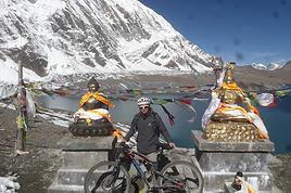
De là tu remontes sur Pokhara (via Tansen**) pour voir les Annapurnas*** : la route entre Béni et Muktinath est quasiment achevée. C'est une piste "caillouteuse" qui permet de voir tous les "étages climatiques" de 800 m d'altitude à 3700 m (besoin d'un permis ACAP et d'un VTT solide) !
De Pokhara, tu rejoindras facilement la vallée de Kathmandou**** avec arrêt à Gorkha* et à Mugling* (prendre le téléphérique jusqu'au temple de Manakamana -> faire cet arrêt au retour).
La vallée de Kathmandou est surperbe à vélo, surtout les 'bords' de la vallée comme la section Namo Buddha-Dhulikhel-Nagarkot-Changdu Narayan (les anciennes routes népalaises en terre battue sont construites sur le sommet des collines avec une vue superbe).
De là possibilité d'un aller-retour jusqu'au Tibet par la "route de l'amitié"...
Pour rejoindre Chitwan, il vaut mieux repasser par Mugling pour éviter le flux de camions qui circulent sur la Tribhuvan highway. La route suit des belles gorges où on peut faire du rafting. Entre Tadi Bazaar et Sauraha, on retrouve une piste défoncée mais roulable.
Ensuite, il restera à finir le trajet par la Mahendra highway jusqu'à Kakarbhitta en faisant un petit détour par Janakpur, voire en remontant jusqu'à Hile si vous êtes en forme ! Mais réservez de l'énergie pour monter à Darjeeling et au Sikkim.
Attention, il n'y a des distributeurs de billets qu'à Bhairawal (Lumbini), Pokhara et Kathmandou...
Bonne route
NB: pour se reconstituer du muscle, il existe l'Everest Steak House à Pokhara et Kathmandou (330g de viande rouge à 4€ !).
Salut
Sais-tu combien faut il compter de km (+-) entre les deux frontières indiennes (Darjeeling-Mahendranagar) en passant par Kathmandou-Pokhara. En fait la route que tu me conseilles et que je zieute depuis quelques temps 😎
Merci pour ces précieuses infos
@+
Jacques
Ps: Et au km 863 tu faibliras mais jamais tu renonceras...😏
Je n'ai jamais calculé la longueur de cette route, sachant que le pays fait 800 km de long et que les routes de montagnes sont en zigzags...
En regardant les dernières cartes Nelles et IGN, il me semble que la route entre Dhulikhel/KTM et Lalbiti/Janakpur doit être achevée. Elle suit la Sun Kosi et permettrait de te faire gagner plus de cent de kilomètres et surtout d'éviter le traffic routier Inde/KTM.
J'ai lu avec attention ce que vous avez écrit sur les routes en vélo au népal.
La route ktm pokara est parait il très fréquentée, y a t il une alternative pour arriver à Pokara sans trop rallonger?
J'ai 3 semaines pour aller ensuite en Inde à dardjeling. 3 semaines, est ce suffisant (je ferai les détours conseillés: Hill, janakpur) , la route est elle pas trop chargée , encore une fois, y a t il une piste alternative à l'asphalte?
je vous remercie pour votre aide
sev.
Les routes asphaltées sont rares au Népal, elles servent au commerce (camions), aux locaux (bus) et aux touristes (minibus). Et en dehors de ces routes, il n'y a pas d'alternative pour circuler entre les différentes parties du pays.
Toute l'année, la route à éviter est Birganj<->Katmandou : c'est l'artère du commerce entre le Népal et l'Inde. Il y a toujours un embouteillage à l'entrée de la vallée de Kathmandou (entre Naubise et KTM).
Sur la route KTM-Pokhara, il vaut mieux éviter la haute saison touristique (mi-octobre/mi-novembre) où il y a un pic de traffic avec les minibus. Dans tous les cas, il faut faire attention à la qualité de la chaussée (surtout après la mousson) et aux pots d'échappements mal réglés des camions et bus...
Cependant, il est dommage de s'encombrer d'un vélo pour visiter un pays qui se visite principalement à pied. En 3 semaines, on peut à peine découvrir la vallée de KTM (10 jours), Pokhara (1 semaine) et Chitwan (3-4 jours), sans compter les treks 'classiques'. A ces 3 endroits, il est possible de louer des VTT.
Le trajet en bus entre les 3 villes coûte environ 4€ (+ 1€ de commission d'agence) pour 5-6h de trajet.
Bonjour Etienne et merci pour tes infos.
Je précise ce que je compte faire pour te donner un peu plus de pertinence au trajet. J'arriverai de Lhasa en vélo parcours classique lhasa KTM. j'ai deux mois pour rallier ces deux villes et fort possible qu'il me reste du temps pour rouler dans la vallée de ktm.
En novembre, donc comme beaucoup, je rejoins des amies pour un trek. Et par la suite, un mois pour rejoindre une amie à Dardjeeling.
En prenant les transports locaux, j'éviterai de rouler sur les axes très chargés que tu m'as cités.
Voilà, je suis au début de ma préparation et ça évolue, ça évolue.
encore merci.
Au Népal, j'avais une carte magnifique dont le nom exact de la marque allemande m'échappe. "Nielles" je crois, sans être sûr.
L'originalité de cette carte consistait en le fait qu'elle ne soit pas axée sud-nord mais horizontalement sur l'axe des Himalaya, depuis le Bouthan jusqu'au Pamir tadjik. Superbe! Un peu à contre coeur et par principe de solidarité cycliste, je l'ai échangée à Lahore à un allemand contre sa carte du Pakistan qui ne m'a qu'à peine servie. :)
Le vélo, c'est bien, même pour celleux qui n'en font pas.
I’m planning to cycle from Morlaix to Brest (via Roscoff and the V45 coastal route). We’ll start riding on August 16th for 13 days (with stops for island visits, surfing, etc.). Is there a lot of traffic at this time of year? I’ve got two kids, 11 and 13, and we don’t like riding in the middle of cars (we’ve already done the Vélomaritime—Caen to Cherbourg—the Loire route from Orléans to Saumur, the Vélodyssée from Nantes to Royans, and the canals like the Nivernais and Bourgogne, where there were plenty of bike-only lanes, which isn’t the case on this route).
Thanks for your help if you’ve already done this route in late August!
Virginie
I’ve got my flight ticket sorted—departing in mid-November and returning in mid-March. I’ll arrive in Santiago and leave from Buenos Aires.
I’ve already been to southern Argentina, specifically Torres del Paine National Park, and I’d love to go back to do the full W trek (I only did the shorter version last time).
I also want to do some hiking and maybe even tackle a summit. I climb and occasionally do some mountaineering, so I’ll definitely be going with a guide.
I plan to start around Temuco in Chile, with the idea of heading toward the lakes, then taking the Carretera Austral.
I’m not sure if I’ll go all the way to Ushuaia—it’s supposed to not be *that* worth it, except for the bragging rights of saying you’ve been to the end of the world.
I saw there are lakes in Argentina too.
I don’t have a precise itinerary, but what I’d love is, once I reach the southernmost point of my trip, to take a mini-cruise to see some wildlife. Any tips for that?
What kind of sleeping bag did you take? Is a 0°C (32°F) one enough?
And one last question: white gas stove or can I get by with my gas stove?
This summer, we’re planning to cycle along the EV 19 that follows the Meuse River from Langres all the way to Rotterdam.
My question is about getting back to Nantes.
Do any of you know what the best return option might be? I’d love to hear about your experiences.
I saw that FlixBus doesn’t take bikes.
By train, I think it’s possible but would involve multiple local trains.
We were also wondering if there’s a boat from Rotterdam to Saint-Nazaire that could take passengers with bikes.
Any tips or experiences you can share would be really helpful—thanks in advance!
Have a great evening
Hi there,
I’ve been road cycling for several years, and I’m about to switch to gravel in the next few days—I’m waiting for my bike, which should arrive this week.
I’m planning a bikepacking trip in a few weeks along the Véloroute V81, also known as the Vélosud, from Biarritz to Le Barcarès.
Has anyone here already done this route? Any info is welcome, whether it’s about the route itself, gear, or accommodation. I’ll prioritize staying with locals as much as possible. On that note, I just signed up for the brand-new site *Guidon et Couette* ((www.guidon-et-couette.fr)), which offers free accommodation between cyclists across the country, but there’s almost no one listed along my route!
Thanks in advance.
Laurent.
I’m planning to build a new touring bike.
I want to prioritize lightness.
That said, I’m tempted by a suspension fork that could offer some comfort on rougher roads.
The recent appearance of gravel suspension forks on the market might meet my needs—at least on paper.
I’m particularly considering the RockShox Rudy Ultimate XPLR fork.
Unlike MTB forks, its travel is short: either 30 mm or 40 mm.
It weighs 1400 g, which is 400/500 g more than a steel fork.
Any thoughts or real-world feedback on this?
I’m also wondering about the durability of magnesium (lower leg) for long-distance bike touring.
And what’s the impact of skipping the manufacturer-recommended maintenance every 50 and 200 hours? That’s bound to happen on a long trip unless you carry extra gear.
More generally, how reliable are these kinds of forks?
Hi everyone,
I wanted to share with you the incredible feat my friend José, who’s 72 years old, is currently undertaking. He left Auterive near Toulouse on Monday, May 18, 2026, on his non-electric bike, heading for the North Cape in Norway!
You can follow his route on the link below—he’s currently in Sweden:
https://thierry-thomas.travelmap.net/jose-de-toulouse-a-nord-cap-2026
You can zoom in on the map and click on each stopover town to see the photos
I’m making an exception and creating a separate post this time, since it’s all about France. In May, we spent a week in Provence, specifically in the Luberon, exploring the cycling routes *Autour du Luberon à Vélo*, the *Véloroute du Calavon* (part of EuroVelo 8), and the shorter *Les Ocres à Vélo* route. Together, they gave us an amazing journey through rolling hills, vineyards, lavender fields still green in spring, and some of the most stunning landscapes in southern France.
It was, of course, the perched villages that impressed us the most. We visited Gordes, Roussillon, Bonnieux, Lacoste, Lourmarin, Ménerbes, Oppède-le-Vieux, Cucuron, and Lauris. Many of them are among the most beautiful villages in Provence, and it’s hard not to agree with that reputation.
One interesting point is the route of EuroVelo 8 in this part of the region. The official path mainly follows the old railway line of the *Véloroute du Calavon*, which is very comfortable and safe. But in our opinion, cyclists traveling EuroVelo 8 around the Mediterranean would discover even more treasures if the route passed through villages like Bonnieux, Lacoste, or Oppède-le-Vieux.
We were also pleasantly surprised by how safe cycling felt. Most of the route takes small local roads, but traffic is light, drivers are respectful, and road design really takes cyclists into account. It’s one of those places where you can ride peacefully even without separated bike lanes.
Our full story:
Around Luberon by bicycle - the most beautiful villages of Provence
You can also find all our cycling travel stories on the forum:
Cycling Thread - Europe’s most beautiful bike routes
Hi there, we’re a group of 4 cyclists looking to get from Treviso in Italy to Munich with our 4 non-folding bikes. It seems complicated! Are there any solutions? Thanks so much.
hello fellow cycling enthusiasts
here’s a travel journal of the cycling tour through the Rhône-Alpes Auvergne region by Claudio
zouli
it was the plan
http://cbandiera.free.fr/parcours/auvergne-Ralpes/
the trip was completed
story being posted online soon
1100 km in 11 days
beautiful and varied regions
Hi there, we’re planning a Munich to Venice bike trip at the end of June 2026. Getting back from Venice to Toulouse by train with 4 bikes isn’t straightforward. What return options have others who’ve done this trip chosen? Any tips or great deals would be much appreciated. Thanks a bunch! !
Hi everyone,
Happy owner of a Pegasus Estremo bike with a Rohloff hub, which is giving me trouble with the SF11-NCX-FT-E-LITE 700C TS 300/0 fork (serial number TD01329060). It’s starting to show its age, and I’d like to repair it to extend the life of my beloved bike.
The suspension is gone, and there’s an oil leak from the seals.
Does anyone know how to repair it? Where can I find parts that are about fifteen years old? Or where to find an identical replacement fork? Just to clarify, the Magura HS11 brakes are mounted using Firm Tech, meaning they’re on pivots behind the fork, facing the frame.
Hi, I'd like to know if anyone has done this route recently or has reliable info.
Does the track exist, and most importantly, is there sand (for biking)?
Any info is welcome.
Cheers,
diego ambilobe: mangaoka, manondro, ramena
vohemar sambava: masondrono, tanambao
Hi there,
New to bike touring,
I’d love to start with a section of the Via Rhona to explore and share (route to be decided).
Looking forward to exchanging tips!
I’m landing in Madagascar with a buddy before the end of April 2026. We’re planning to bike around for about twenty days or so. We don’t have a specific goal other than exploring the country and meeting the locals.
Ideally, we’d prefer a loop route starting from Antananarivo with a good chunk of it along the coast. On the bike side, we’re used to riding 6 to 8 hours a day, depending on the needs, encounters, and mood 😉 Any feedback or tips from trips around this length?
A big thank you to Lazarou for all the info you share in this forum!
I'm passionate about Morocco, which I cycled through back in 2009.
Last year, my wife and I explored the High Atlas by tandem. Completely smitten, we're heading back in April (Anti Atlas) and May (High and Middle Atlas), still on our tandem.
Do you have any info on the track between Amezri and Ali Ait Nito? Are the river crossings in the Tessaout still there? It's not easy to navigate with a loaded tandem... especially if the river level is high due to this year's heavy snowmelt!
Thanks in advance for any tips you might have, and best wishes for health in this new year!
Claudio specializes in the route of the Savoie lakes
Here are his travels
Between Bornes, Chartreuse, the Savoie foothills, and Dauphiné
Five lakes: Léman, Annecy, Paladru, Aiguebelette, Bourget, not to mention a few ponds along the way
Plenty of accommodation options: camping, hotels, and more...
A lovely route not far from his place
Rural and quite peaceful
A road cycling route created by Serge B...
Tout d'abord... bonne année ! De belles routes à vous en 2017 !
Je voyage depuis quelques années avec un VTT de très bonne qualité mais équipé de freins à disques hydrauliques. Je vis (pédale) avec l'inquiétude d'avoir une panne (fuite, bulle d'air, chaleur qui fait que le liquide...). Mon vélociste me dit qu'il est impossible de les changer pour des V brakes.
Qu'en pensez-vous ? Est-ce que je prends un gros risque à continuer (seule) avec ces freins ? D'avance je vous remercie pour vos bonnes idées.
First post here to share a quick recap of our west-to-east bike trip along Algeria’s coast in January 2025.
It was just the two of us—my partner and I—with French passports and not a word of Arabic. No friends or welcoming hosts in the country.
Under those conditions, we’d strongly advise against going.
Our original plan was to follow the coast from Algiers to Tunis. We ended up cycling from Algiers to Béjaia, then took the train from Béjaia to Annaba (with a stop in Constantine), and finally biked to the border.
We were tailed by police the whole way—whether on our bikes, on the train, or even on foot while exploring towns. On top of that, we couldn’t wild camp and were limited to the few state-approved hotels that accept foreigners. Under those circumstances, connecting with locals was especially tough.
With such an omnipresent and intrusive police presence, we’d definitely recommend against this destination for bike touring. A really sad situation that completely cuts you off from the local population...
We’d been warned, we went to check it out, and we weren’t disappointed!
Hi there,
I’m planning the route to cycle from Lille to Nordkapp with my partner.
Duration: 3 months, from May 1st to July 31st, 2026.
In the attached details below, I need to add some "non-riding" days (rest days, basically).
So I’m looking to "shorten" the trip by taking ferries or trains for some stretches. Which areas could I skip?
Thanks in advance for your great tips.
Have a good evening.
https://www.komoot.com/fr-fr/collection/4023980/-lille-cap-nord-1er-mai-au-31-juillet-2026?ref=collection
I’m planning to bike back from Poland this summer. Does anyone know a way to ship it there without having to take it apart? Otherwise, it’s a real hassle to fine-tune all the settings before departure!
Thanks in advance.
Hi, has anyone recently bought Primus or Butagaz gas, possibly puncture-style, in Dubrovnik or the surrounding area? Same question for Albania... thanks. aichatou
Just a few words about the loop I did by bike in Yunnan.
Entry and exit
I entered China through the Sino-Vietnamese border crossing at Lào Cai / Hekou under the 30-day visa exemption currently available to French nationals and others.
The process was simple and quick. A Chinese police officer even helped me complete my electronic pre-registration at a computer kiosk. I wasn’t aware this formality was required—it’s similar to Thailand’s TM6.
No issues with the bike.
I left the country via the Sino-Laotian border crossing at Mohan / Boten.
The atmosphere was a bit chaotic there, but again, no problems with the bike.
The timing
I visited Yunnan in February 2026.
Weather-wise, at higher altitudes (between 1,500 and 2,000 meters), it was around ten degrees at night and in the mornings, and around twenty degrees at the hottest part of the day.
I had two days of rain, so I took the bus to keep moving. Otherwise, clear blue skies.
Culturally, Chinese New Year fell on February 17th (and the 15 days following), right in the middle of my trip. Because of this, my take on the traffic might be off.
Accommodation and food
I always found a hotel to stay in for prices ranging from 8 to 15 €. Except in Kunming (the capital), where many hotels were fully booked (Chinese New Year). I ended up at a 100 € hotel with great value for money.
A bowl of noodles costs about 1.5 € on average.
Onboard electronics
Since my smartphone doesn’t support eSIMs, I subscribed to a China plan with my carrier. Otherwise, for much cheaper, Alipay offers eSIMs for foreigners that allow access to services usually blocked for Chinese users (WhatsApp, Facebook, etc.).
An internet connection is essential for paying with Alipay or WeChat, as this payment method is widespread.
I only managed to use Alipay.
Either way, always carry cash because sometimes there’s no signal, or the merchant only accepts WeChat.
Also, it’s best to bring a power adapter when you arrive rather than struggling to find one.
Traffic and roads
The Chinese aren’t reckless drivers. They follow traffic rules and watch out for cyclists. This is slightly less true in Xishuangbanna (the region bordering Myanmar and Laos).
In urban areas, there are almost always wide bike lanes, separated from other roads, where bikes, electric mini-scooters, and scooters share the space pretty harmoniously.
The roads are in great condition, and traffic is generally manageable—even light—except for one stretch (Eshan -> Yangwu).
Most traffic is absorbed by expressways, China’s equivalent of highways: toll roads that are off-limits to slow vehicles.
You’re never far from these expressways; sometimes you even ride alongside them, which can be noisy at times.
The climbs are usually reasonable, around 5% to 6%. From what I remember, the steepest section was between Menglun and Mengla, with gradients of 8% to 10%, sometimes more.
Riding at these altitudes—though modest—took a bit of getting used to.
The route
I didn’t plan anything in advance. My only goal was to reach Kunming. I don’t know why, but just hearing the name of that city, like Yunnan, always felt dreamy to me.
Hi! I’m planning to visit the Stockholm Archipelago by bike in early April.
Do you know if the boats will be running between the different islands at that time of year? For those who’ve already been, all your tips and recommendations are welcome—accommodation, etc. Also, do you know where I can rent a bike in Stockholm? Thanks so much in advance for your help!
Hello there, pedal-powered Young Boys!
Claudio (still from Faverges)
dreaming about a cycling getaway in Italy from Faverges (train all the way to Turin)
from Turin down to Venice along the Po River and back via the Padana (Alta Italia da attraversare – Northern Italy to cross)
The tricky part is getting from Chioggia to Venice.
I read it’s possible by hopping on a boat from island to island,
but it sounds a bit stressful.
Has anyone already tackled this route?
I’m currently looking for a bike to do my first bike trip across France, with the ultimate goal of cycling through Latin America. I’ve got a lot of questions and I’d love to hear if you have any answers or advice to share.
First off, I’ve been through this before with hiking. I want to get top-quality gear right away. When I started hiking, I ended up buying everything three times—first beginner gear, then intermediate, then expert, etc.
For biking, I’d prefer to skip that process and invest right now in a bike that could ideally handle Latin America.
I’ve set a total max budget of around 5000 € (roughly 4000–4500 € for the bike and the rest for accessories: panniers, helmet, cycling shorts, etc.).
So, I’ve got quite a few questions:
* I’ve read in several places that some people recommend buying the bike directly in Latin America. Since I need a first bike to train in Europe, would it be better to buy an entry-level bike in France (and sell it before the big departure)? Or is it preferable to start right away with my final bike to get used to it? Is buying it there just to save a bit of money?
* For a long-term trip (around six months) in Latin America, is it better to go for a gravel bike or a mountain bike?
* Should I buy a new bike or a refurbished one? Even more so given that I’m planning a long trip—could a refurbished bike end up causing more breakdowns?
If you have any advice on models, technical features to prioritize, or recommended sellers or resellers, I’d love to hear it. I’m a total beginner—I’ve only just started watching videos and reading up on the subject, and all the technical specs are new to me!
Calling all travelers.
We’ll be landing at Lyon Airport and want to bike to La Verpillière train station (with panniers and camping gear, etc.) to catch a TER to Voreppe.
What’s the safest route for this bike trip?
Thanks in advance
hi,
I'm planning a recumbent bike trip from the Pyrenees to Greece. On the EuroVelo 8 route, it doesn't specify the path through the Alps.
Are there any experienced cyclists here who can tell me where they go to avoid climbing too high?
Also, is there another traveler/bike forum better suited for broadening the responses?
thanks