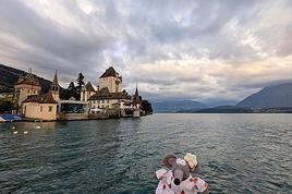
Je voudrais faire mon premier trek l'été prochain. Pour l'instant je m'entraine en salle pour être le plus en forme possible; ensuite je ferai des sorties au Salève le dimanche avec une association, ce sont des marches qui durent entre 5 et 8h.
Je voudrais être prête pour une randonnée l'été prochain. J'avais pensé faire une partie du GTA ou alors le tour du mont blanc. Avez-vous des conseils? ou d'autres idées de randonnées en Suisse??
Une rando. ... de combien de jours ? ton entrainement sera en rapport de çà .
Iras tu le soir en refuge avec demi pension ou tu bivouaqueras ?
Je pense que le GTA ou le tour du mont Blanc sont de beaux challenges ..... @ + ... lef .
Merci de me répondre.
J'aimerais bien faire un trekking d'une semaine environ et de bivouaquer.
Côté condition physique, je monte trois étages à pied je suis essoufflée, tu vois. Y a du travail c clair mais c'est pour cela que je prends quelques mois pour m'entraîner. Les sorties du dimanche au printemps devraient me faire aussi du bien.
Sinon j'ai 27 ans, étudiante.
Voili voilou, j'attends des conseils.
En salle de fitness je "m'amuse" à marcher sur la tapis de course en augmentant l'inclinaison.
Il y a plusieurs livres des toutes les cabanes et refuges de Suisse que tu peux trouver facilement en librairie.
Il y a quelques jolies randos a faire en Valais et dans le massif des Diablerets.
J aime bien trekker dans le val de Bagne et a Derborence.
Je ne suis pas en Suisse actuellement mais pour le primptemps, je pourrai te donner quelques itineraires sympas dans ces regions.
Je te conseille de commencer par des treks de 2-3 jours en augmentant petit a petit la duree et la difficulte avant de t attaquer a un tour d une semaine. Tu auras d avantage de plaisir en bonne forme physique.
sans vouloir jouer les mauvaises langues, mais juste pour vous faire un cllin d'oeil....pourquoi ne pas parler de simple randonnée plutôt que de trekking ? 😉
sinon, en suisse, tu auras le choix, que ce soit dans le Valais (le plus parcouru) ou l'oberland et même me Tessin, tu auras de quoi faire toute ta vie .
Regarde par exemple sur une carte dans le coin du Val d'Anniviers .....ou encore vers les 3 cols (Susten/Grimsel....), inépuisable, bien balisé et confortable dans les cabanes, que demander de plus ?
Il est important de percevoir combien votre propre bonheur est lié à celui des autres, il n'existe pas de bonheur individuel totalement indépendant d'autrui.....(Dalaï-Lama)
Pour ma part, j'ai bien aimé, à ma reprise des randos "autonomes", la partie du GR 5 (appellation française ... - les Alpes du N au S ...) entre le Léman et CHAMONIX - Avec un "demi" Tour du Mont Blanc, ça peut faire un superbe trek ... La portion entre SIXT et CHAMONIX est, notamment, un de mes secteur préféré de balade ... - Bonne chance pour tes projets et surtout, quitte le plus souvent possible les salles de musculation (c'est nul comme entraînement !!) On peut encore faire de superbes balades à cette période ... (les crêtes du JURA, au dessus de Genève, par exemple ...) - C'est en marchant .... Bonnes balades ...
Merci pour ta réponse. Je note les endroits que tu me conseilles et j'irai certainement faire un tour en librairie...
Oui pour le printemps je suis preneuse de tes itinéraires...
Pour la durée de la rando, tu as raison, je vais commencer tout doucement par deux trois jours et augmenter progressivement.
D'ici là, je vais commencer à acheter du matériel.
j'arrive un peu tard dans la discussion mais un petit message juste pour te faire part de ma rando de cet été. j'ai contourné le mont rose en partant de zermatt. une boucle vraiment sympa et à portée d'un randonneur à peu près entraîné. tu es jeune, le problème ne sera pas le physique mais peut-être le mental (ce qui ne veut pas dire que tu dois arrêter de monter tes trois étages à toute allure 😛), surtout ne pas abandonner même en cas de coup de fatigue et garder le moral (moi, je pense à la grosse bouffe et à la convivialité des refuges...). dans la rando dont je te parle, tu passes entre autre par un flanc du mythique mont cervin qui est magnifique par beau temps et le glacier du mont rose est pas mal non plus; les refuges sont confortables et agréables. on a mis 6 jours sans forcer l'allure donc c'est l'idéal. bref, détente, souffrance physique mais repos spirituel garanti (surtout après des exams, ça évacue... 😉), quant au paysages, une vie n'est pas assez pour s'en lasser... petit bemol: c'est aussi une des rando les plus pratiquées par les touristes, tout dépend de ce que tu recherches.
voilà, si tu veux de plus amples infos, n'hésite pas à me contacter, je pourrais te détailler tout ça. sinon, pour les amateurs de rando peu ou mal entraînés, mais qui tennent absolument à faire un trek, je conseille au passage la parc de la vanoise dans les alpes et le tour du glacier eponyme: paysage superbes, niveau de difficulté correct (mais sans roupiller non plus!), refuges très abordables sur le plan financier.... à faire avec des amis pour évacuer l'esprit!
je ne sais pas si c'est a ca que tu penses, mais il y a la haute route dans le valais. c'est une randonnee d'une semaine a la limite des neiges eternelles avec nuit en cabane et tout. ma soeur de 16 ans l'a fait cet ete sans probleme. son seul entrainement etait les marches qu'elle a fait en famille pendant deux ou trois semaines de vacances donc meme si c'est fatiguant, c'est a la portee de tout bon voire moyen sportif.
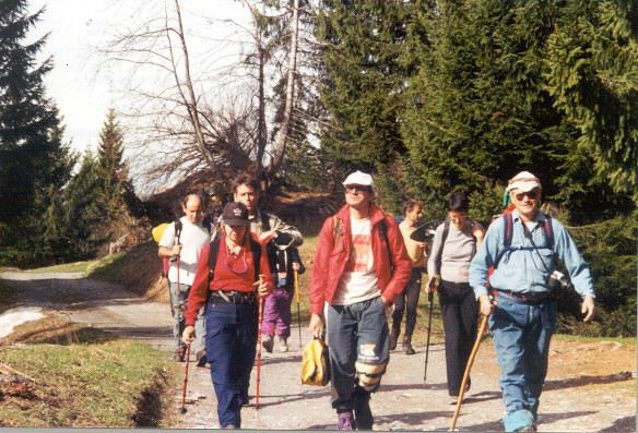
Genève (Suisse) : Randonnées pédestres gratuites au Salève. Tous les dimanches, les amoureux de randonnées pédestres se donnent rendez-vous à 10h au terminus du bus 8 à Veyrier-Douane (et non à Veyrier-Tournettes, à 100 mètres de la douane à l'intérieur de la Suisse, départ à rando-saleve.net). Un responsable de l'Association Genevoise des Amis du Salève (AGAS) vous y attend par tous les temps. Il n y a pas d'inscription préalable. Selon le circuit choisi, comptez 5 à 8 heures de marche . Départ à pied du point RDV. De bonnes chaussures de marche (crampons en hiver, chapeau et crème solaire en été), imper ou parapluie, passeport, argent, pique-nique et boisson ainsi qu'une bonne condition physique sont indispensables.
Site internet : rando-saleve.net - Contact : Tel: ++41’22'796’41’33.
Geneva, Switzerland : Free hikes on the Saleve. Every Sunday, let's go hiking (a gradient of 800 meters, 3 hours hike-up). Meeting at 10 am at the terminus of bus No 8 at Veyrier-Douane (not at Veyrier-Tournettes, 100 metres from the border direction Switzerland, departure at rando-saleve.net). A responsible (excursion leader) of the Association Genevoise des Amis du Saleve (AGAS) welcomes you in all weather. No prior registration necessary. Depending on the route chosen, you will expect a 5 to 8 hours hike. Departure of the hike from the meeting point. Hiking boots (crampons in winter, hat and solar protection lotion in summer), raincoat or umbrella, passport, money, picnic and something to drink as well as good health are indispensable.
Excursiones gratuitas al Salève : La "Asociación Ginebrina de Amigos del Salève" (AGAS), organiza excursiones gratuitas al Salève, todos los domingos, en grupo, sin inscripción previa; cita a las 10.00 h - rando-saleve.net (no Veyrier-Tournettes, salida ). Contar entre 5 y 8 horas de marcha (de las cuales 3 horas de subida - 800 m de desnivel). Se recomiendan buenas botas de marcha, impermeable o paraguas, pasaporte, euros, comida y bebida (pic-nic); es indispensable tener una buena condición física.
Gratis Bergwanderungen auf dem Salève
Jeden Sonntag treffen sich die Liebhaber des Wanderns um 10Uhr an der Endhaltestelle des Bus 8 in Veyrier-Douane (und nicht Veyrier-Tournette, 100 Meter vom Zoll auf schweizer Gebiet, Aufbruch um 10h05). Ein Verantwortlicher des Genfer Vereins der Freunde des Salèves (Association Genevoise des Amis du Salève, AGAS) erwartet Sie dort bei jedem Wetter. Es gibt keine vorherige Anmeldung. Je nach gewählter Route, dauert die Wanderung 5 bis 8 Stunden, davon 3 Stunden bergauf im stetigen Rhythmus (800 Meter Höhenunterschied). Gute Wanderschuhe, im Winter Steigeisen, im Sommer Kopfbedeckung und Sonnencreme, ein oder zwei Stöcke, um das Gewicht besser zu verteilen und die Gelenke zu schonen (sie werden Ihnen dies später danken), Regenkleidung oder Schirm, Pass, Geld, Picknick und Getränke sowie eine gute körperliche Verfassung sind Voraussetzung.
Je poste ce message à l'attention de tous les randonneurs et randonneuses qualifiés! En effet, une amie moi (nous avons 19 et 18 ans) souhaiterions faire notre…
Je suis nouveau sur ce forum, et je suis actuellement entrain de préparer ma première randonnée. Je ne m'y connais donc pas beaucoup en matériel, c'est…
J'aimerais partir en rando en Suisse (alpes ou en plaine) la première semaine d'octobre (~3 à 6 jours). Cependant, vu la saison un peu tardive, je ne sais pas…
Bonjour,
Nous souhaitons faire le trek de 4 jours reliant Mestia à Ushguli sans agence. Il est précisé dans les descriptifs qu'il existe des hébergement à chaque étape, mais on ne trouve pas d'info sur ces hébergements. Quelqu'un a-t-il des infos et un avis sur ce parcours?
We're planning to trek in Peru and Bolivia and would love to find some local agencies.
If you know any, could you share details on prices and, of course, the names of the agencies?
Which trek would you recommend?
Elocine
Je pars en autonomie totale sur un trek au Maroc (10jrs) Imilchil - Aghbalou.
Trouve t-on des cartouches gaz à vis (Coleman, Primus) à Marrakech (adresse) ou villages entre Imilchil - Aghbalou ?
Si non , trouve-t-on des cartouches Butagaz pour camping-gaz (petit volume 230 gr ...)
Merci d' avance pour vos réponses
Hello, I’d like to embark on a little trip in my home country, Switzerland. I’ll start walking from La Cure, heading toward Le Noirmont first, then I’ll improvise my route—but it’ll probably follow the French border... at least as far as Lac de Joux.
I’ll decide day by day how much farther to go after that. My goal is to stay in nature as much as possible, wander around for as long as I can, and restock food in villages or towns along the way.
I’m thinking of mostly camping, but we’ll see if I end up in a hotel or another campsite depending on my route.
I’d love to reach La Chaux-de-Fonds on foot... maybe even Delémont.
The whole thing should take about a week, give or take.
I’ll be bringing my dog, and I’m preparing for this as soon as I’m ready.
Any tips to make sure everything goes smoothly for us? Things I should know—or avoid? What about shepherds with their flocks of sheep? And isn’t hunting season open right now?
I’m not sure if what I’m planning is even doable, which is why I’m asking around.
This’ll be my first time doing something like this—wandering in nature *and* with a dog. I’m really excited for this adventure... and I need it. Thanks!
We’re really keen on ecosystems and want to hike in "natural" ancient forests—not planted woods or areas heavily degraded by human activity. Travel guides (like Lonely Planet) don’t provide much info on this. Could you point us to the most interesting spots?
Thanks in advance for your tips.
We wish you happy holidays and a fantastic 2026, full of discoveries!
Claire and Albert
Hi, this might not be the right section, but I’d like to know if it’s possible to start mountaineering with another person without necessarily hiring a guide. We’ve done quite a bit of hiking but not mountaineering—we’ll just do a half-day glacier course. After that, we were thinking of starting with La Grande Motte and the Pointe de la Traversière, which were recommended to us. Honestly, for things like roping up and knots, I’ll learn at home with lots of videos and a book.
Hi,
I don’t know Switzerland at all and was wondering if Vallée des Joux and especially Dent de Vaulion are packed early in the morning or late in the afternoon in July and September?
If so, do you have any quieter spots to recommend in the area, or in Luxembourg (yes, I know it’s not the same country 😉)?
Thanks a lot!
I’m starting this thread—lots of travelers here have done this trek.
When RMS is mentioned, it’s this agency: Ruwenzori Mountaineering Services (with an *s*), because there’s another one online called Ruwenzori Mountaineering Service (no *s*).
Their site:
www.rwenzorimountaineeringservices.com/
From what I gather, it’s the local mountain guide agency certified by the government?
Jaimerais savoir si quelqu'un aurait fait des treks sur le Ruwenzori et combien ça coute en moyenne, les infrastructures, les paysages la sécurité sur les lieux, merci beaucoup. J'attends avec impatience vos réponses.
We’re leaving in 9 days for a two-week trip to Madeira, mainly to hike.
From my research, I’ve found that since last year, access to most trails—and systematically for the most popular ones—is now paid. You have to pay an access fee of 4.50 € per person per classified hike in 2026, and even 10.50 € for the most iconic hike: Pico Arieiro to Pico Ruivo. When paying, you also have to choose a day and a 30-minute time slot for your start time. Of course, this reservation is neither changeable nor refundable, even if the weather that day is terrible.
Personally, given the massive influx of tourists to the island in recent years, I don’t mind paying a fee to help maintain the trails. Similarly, setting a limit on the number of people who can hike them per day is certainly preferable to preserve this priceless heritage.
However, what’s much less fair is that in reality, most of the available spots are reserved: 1/ for Madeira residents (which is normal); 2/ for "economic operators" (meaning local tour operators). For example, if you’re a non-resident (independent tourist), no booking is possible for the Pico Arieiro hike for an early morning start before September! So, unfortunately, we’ll have to skip this hike.
It’s the same issue for Ponta de São Lourenço, the 25 Fontes, Pico Ruivo... in short, all the most popular hikes. Oh well, we’ll skip those too!
So my question is: which hikes do you recommend where we won’t face the huge crowds that the others get? And where we can book the day before for the next day, taking the weather into account?
Finally, a quick accommodation question: we’ve booked the first week in Funchal, but I haven’t decided yet for the second week. Do you have any advice on where to stay in the south or north, preferably avoiding overly concrete-heavy and touristy spots?
I’m reposting about the logistics for Samaria Gorge.
I’d love to get recent info, especially about whether it’s possible to park my car in Omalos, do the hike, and then catch a bus back to my vehicle.
In theory, it’s doable, but when you check the KTEL website, there aren’t any feasible schedules listed. If anyone has recently organized this with reliable, verified details, I’d really appreciate it. Thanks in advance!
Hi there,
We’re flying from Montreal to Lyon this August to go hiking in the French Alps. We’ve rented a car and will be staying at campgrounds. We’re planning to do day hikes and want to stay a few days in one spot, do a few hikes, then move on to our next camping spot. Could you share your favorite spots or any recommendations for places to spend a few days with great hikes?
A few details:
We arrive in early August and leave in early September.
We’re looking for day hikes (or shorter), moderate difficulty, with a cumulative elevation gain of no more than 1000m, and of course, beautiful scenery!
We’d prefer not to drive too much—maybe it’s best not to head too far south and deal with unnecessary heat?
Along the same lines, if you know of any great campgrounds where we can start our hike directly without needing the car, we’d love to hear your suggestions!
Bonjour
Souhaitant faire de la randonnée sur cette île, je voudrais d'abord savoir quelle serait la période la plus favorable sachant que j'avais passé quelques jours en novembre 2018 pas pour cette activité mais plus pour une simple découverte de l'île et le temps n'était pas top notamment en montagne. Donc peut on choisir une organisation en étoile sachant que je louerai un véhicule avec éventuellement 2 points d'hébergement.
Je n'envisage pas d'intégrer une structure mais de partir à 2 et de s'organiser sauf si vous me conseillez une agence locale ou un guide local. Enfin même si je compte me procurer les différents supports, carte et topo guide plus gps je vous remercie de bien vouloir me communiquer les randos à faire en priorité
Merci beaucoup pour vos informations
I’m planning to do the Mercantour crossing following the Randoxygène route in mid-July.
I’m used to hiking in the mountains, but I sometimes get vertigo, for example on ridges with drops on both sides. I wanted to check if there are any T4 or T3-T4 sections and find out if there are any very exposed passages—and if so, where—so I can plan an alternative route.
Can anyone give me some info on this?
Thanks!
I’m planning a trip around Cap Corse and the AGRIATES in 2026, from May 8th to 15th (there are still 2 spots left, by the way! Just DM me if you're interested).
I’d love to know which hikes are worth prioritizing in the AGRIATES. We’ll be staying in SALECCIA for two days as our base—what should we focus on from there?
A round trip to IGNHU beach? Any other suggestions?
For Ostricano, I think it’s too far for a round trip...
Thanks for your tips!
Have a great day,
Anie, Toulouse
I’d like to get some info about the GR10 Pyrenees traverse. I need help planning the daily stages and accommodations—my wife isn’t an experienced hiker but walks a lot, so I’d like to schedule shorter walking days and thus a longer overall trip in terms of number of days.
Could anyone give me some help and advice?
Best regards,
New to this forum, I’m planning a pretty big project for 2028.
I’m heading to Nepal to do a trek from Kathmandu all the way to Everest Base Camp (a cool 5,300 m 😄).
This trek is a bit special because even though I’ll be part of a group, I’m going solo (so far, no problem—I’m used to it). But it’s my first real trek, and it’s also a humanitarian one: once I reach base camp, I’ll stay an extra week to help clean up the waste left by tens of thousands of climbers! Since I’m originally from South America, from two countries that share the Andes, I have a deep respect for mountains—they fascinate me. So Everest… it’s kind of the trip of a lifetime!
So, a little question for those who’ve done treks to Everest before… any tips for good mental preparation (I’m already working on the physical side)?
Hi there, I’m planning the Annapurna Circuit for March 2027 and I’m looking for a local agency with a local guide—preferably French-speaking—to arrange this trek for us. Any suggestions? Thanks
Hello!
We’re spending a few days in Toraja country at the end of May. We’d love to do a day trek—taking our time—on a route that’s stunning in terms of scenery, but not a level 5 in difficulty!
Any suggestions you can share, please?
Thanks in advance
I’d like to do the Mare a Mare Sud in May over 4 days. I’ve found quite a few places to stay along the route, but I’m stuck on the start and finish.
I’ll be arriving by plane on Sunday evening and would like to start pretty early on Monday morning. Ideally, accommodation right at the trailhead (Alzu di Gallina) would be amazing, but I can’t find anything. Any tips?
Also, for the transfer from Figari Airport to Porto Vecchio or Alzu di Gallina?
At the end, I’d like to pick up a rental car—any advice on that too?
I’m traveling solo by plane to Catania in May and plan to hike the northern side of Etna, starting from Linguaglossa where I’ll arrive by bus. After that, I’d love some info on how to get up to Piano Provenzana (shuttles or hitchhiking), since it seems there’s no public transport except in the summer. Can you sleep there in a free or cheap refuge, or camp? And how far up can you go without having to hire a guide? Thanks in advance. Bernard.
Bonjour a tous,
je pars en voyage au Maroc en aout et nous allons commencer par nous arrêter a Chefchaouen(nous sommes en voiture).
Ma question: quelqu'un peut il m'indiquer un itinéraire de rando en boucle d'entre 5 et 7 jours aux départ de Chefchaouen dans le parc de Talassemtane passant si possible par le pont de dieux?Ou un guide papier qui en reunis quelques uns?
Nous privilégions le camping sauvage et les gites.
Merci d'avance
Hi there, for those who’ve been recently—is it possible to find other solo travelers in March on the island to share transport or room costs? It doesn’t seem easy to travel on a budget.
If you have any recommendations for simple lodgings or places with dorms, I’d love to hear them.
For those who’ve done multi-day treks while moving around: do you need to bring your own sleeping bag? I’d love to hear about itineraries you’ve done without a guide, just with a map and GPS.
Thanks, and have a great day!
Hi everyone!
We’re planning a 15-day road trip to Scotland this summer, specifically to explore and hike on Lewis and Harris—places we’ve never been before. We’ve visited other islands on previous road trips in Scotland (we usually go in April for a week). This would be our first time in Scotland in the summer and for 15 days. We’re looking at late August to early September.
I’m currently drafting the itinerary. We’d be crossing from Ullapool and were thinking of spending 3 nights on Harris and 4 nights on Lewis.
Does that sound balanced to you? Is it better to keep the same accommodation on Harris and the same on Lewis to explore the area? I’d love to hear about any past experiences you’ve had on these islands.
Thanks!
Hi there, I’m trying to leave for 15 days very soon to São Vicente. I’m either looking to join an agency or figure things out on my own to go hiking on one of these islands or both. From what I’ve seen, it’s not easy to organize with local transport, so it gets expensive. Can I use the services of a small local agency? I’m looking for the simplest way to hike for several days. Also, how do you get from São Vicente to São Nicolau? Thanks in advance and have a great day!
Aichatou
I’ve been wanting to do this for several years, and this year’s the one. Next September, I’ll be trekking in Tusheti (Georgia), from Omalo to Shatili.
Of course, I won’t be renting a vehicle that’d just sit unused. No problem getting to Pshaveli, but from there to Omalo, it’s a dirt road (still the case?)
There must be some form of public transport since there are so many guesthouses, and not all travelers come in a 4x4.
If any of you have been to Omalo, could you confirm that these shared transports exist and how often they run?
we’re planning a trip to Yellowstone and hoping to do a three-day backcountry hike if we get a permit.
if any of you have done this before, could you let me know if it’s possible to find water along the way? And if we can transport it, are we allowed to use a stove?