Je part au Népal du 13 au 30 décembre 2014
Je vais faire le Langtang trek en solo, sans guide et porteur
J'espère trouver a Kyanjgin Gompa un guide possédant le matériel de camping nécessaire pour passer le col du Ganja pour m'accompagner jusqu'a Tarke Gyang
j'aimerais connaitre votre avis sur la faisabilité de ce projet
je suis preneur d'information concernant le trek en hiver
J'ai fait l'année dernière du 17 au 24 janvier le Tamang heritage trail sans guide et porteur accompagné de ma fille de 5 ans (Thambuchet/Gotlang/Tatopani/Thuman/l
Lingling/Briddim/Syabrubesi)
Tout d'abord, je te recommande de la prudence. Quelques ennuis et drames ont eu lieu par le passé pour les femmes seules dans cette région. La prudence serait que tu prennes au moins un porteur jusqu'à Kyanging pour ta sécurité ( maxi 3000 rp pour trois jours, c'est pas trop cher la sécurité ).
Sinon adresse toi au Lovely Guest House au centre du village, petit lodge et demande mon ami Jhandu il saura régler ton problème.
Pour le col Ganja la c'est à voir, l'automne a été chargé en neige ( je suis rentré il y a 1 semaine ). Il se peut que tu ne puisse pas passer, si le temps ne c'est pas amélioré et la hauteur de neige accrue.
Je part au Népal du 13 au 30 décembre 2014
Je vais faire le Langtang trek en solo, sans guide et porteur
J'espère trouver a Kyanjgin Gompa un guide possédant le matériel de camping nécessaire pour passer le col du Ganja pour m'accompagner jusqu'a Tarke Gyang
j'aimerais connaitre votre avis sur la faisabilité de ce projet
je suis preneur d'information concernant le trek en hiver
Je l'ai fait à la mi-mars ( 2010) il y avait beaucoup de neige des passages difficiles ( rochers branlants instables ;éboulements) des passages verglacés très pentus où mes crampons loués à KTM m'ont lâché je me suis fait la peur de ma vie! le guide faisait ses prières et aspergeait les 4 points cardinaux avec du rakshi et une fois le col franchi à dit:"On a eu de la chance!"
Après le col encore 3 jours de marche entre 4000m et 4500m souvent dans la neige et on ne rencontre aucun village ni personne.
Je n'ai plus les coordonnées du "guide!" mais je peux te donner celle d'une Tamang vivant à Toulouse qui pourrait sans doute les retrouver...
Le Ganja la est considéré comme un des cols les plus difficiles du Népal...si les conditions météo sont bonnes et pas de neige c'est faisable mais dans le cas contraire ça peut être cauchemardesque! Rien à voir avec le Laurebina pass ou le Tamang trail!
Bonjour et merci pour les conseils
Tout d'abord je suis un homme (j'utilise le profil de ma femme )
Excusez moi de cette confusion
Thierry a tu passé ce col avec Jandhu?
Tu rentre du Nepal , peux tu me dire quel trek tu as fait ?
Merci
Bonjour Djalma et merci
Peux tu me donner des précision sur ton matériel: sac de couchage , matelas ...
Quel était la composition de votre équipe?
Tu as engagé guide et porteur a Kathmandu?ou Khyanjin Gompa?
J'aimerais aussi ton sentiment sur les paysage et l'intérêt de cette portion du trek
Merci beaucoup
Je suis monté en aller-retour fin Octobre 2007, de la neige jusqu'au genou, le passage du col était impossible.
Il faut faire en fonction des éléments du moment. En ce moment je sais par mon ami Jandhu qu'il y a bcp, bcp de neige.
En plus du travail effectuè avec mon Association ( voir le blog : http://thierry-manojnepal.blogspot.com ) , nous avons fait un mini trek de 5 j en direction du Rupina La pass vers le massif du Manaslu, mais la météo ( neige ) ne nous a pas permis de dépasser les 4000m ( même époque que les 40 Dc des annapurnas ). Nouveau Trek que mon guide souhaite appeler le Bauddha himal kharka trek ( trek en bergerie du Bauddha himal ). Un nouveau circuit qui ne passe pas par le trajet classique du Rupina La, et qui ne traverse pas le Rupina mais redescend vers Laprak.
a+
As tu un moyen de joindre Jandhu ?
J'aimerais beaucoup avoir son Avis.
Combien de temps faut il pour arriver au col a partir de. Khyanjin Gompa?
J'ai l'impression que c'est la partie la plus difficile techniquement .
Peux tu me donner des précision sur ton matériel: sac de couchage , matelas ...
Quel était la composition de votre équipe?
Tu as engagé guide et porteur a Kathmandu?ou Khyanjin Gompa?
J'aimerais aussi ton sentiment sur les paysage et l'intérêt de cette portion du trek
Salut
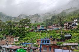
Comme je l'ai dit plus haut j'ai fait ce trek en fin Fevrier/Mars 2010 :Départ de Sundarijal ( Helambu) Passage du Laurebina( 5cm à 10 cm de neige), descente sur le Langtang par les lacs de Gosainkund et Thulo Syabru puis direction ouest vers Gatlang et le Tamang trail;ensuite remontée de la vallée du Langtang puis passage du Ganja la vers Tharkekiang et Sermatang; retour en bus Sermatang -Kathmandu.( 08h ou 09h)
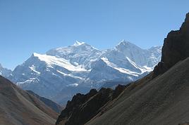
Sur VF rubrique compagnon de voyage j'avais trouvé comme compagnon une personne mariée à une Népalaise( Tamang) du Langtang. Nous sommes devenus amis depuis! Nous sommes donc partis avec le beau frère Népalais( Ang Tsring) et un de ses amis comme porteur( Pema)... A Kiangin Gompa on avait RDV avec un vrai guide pour passer le Ganja la . Ce guide devait nous fournir piolets et crampons... mais il s'est avéré que lui seul avait un piolet! Mes crampons loués à KTM m'ont lâché sur une pente verglacée ( un boulon s'est cassé!) Nous avons campé dans un mètre de neige à 150m du col. J'avais un duvet peu performant( depuis j'en ai acheté un plus performant mais il ne m'a plus servi!) comme matelas on avait le minimum: un morceau déchiré d'1/2 cm de mousse) J'ai dormi tout habillé avec 2 paires de chaussettes ma veste de trek et mon bonnet!) La nuit on entendait les rochers qui dévalaient la pente menant au col et qui venaient s'échouer à 50m de la tente! Le lendemain les derniers 100m pour rejoindre le col m'ont paru interminables; les rochers étaient instables et les chutes de pierres nombreuses!On devait pas mal s'aider des mains et mettre une corde fixe pour le porteur. Derrière le col c'est un pierrier immense et une descente plutôt raide puis 3 petits cols avec tjs de la neige lors de notre passage..Le dernier jour on a pas pensé à faire le plein d'eau et on n'en a pas trouvé de la journée avant d'arriver très près de Tharkékiang. Pendant 4 jours on a pas vu âme qui vive et bien sûr aucun village.
ça a été une très belle expérience( paysages de montagne magnifiques impression de solitude totale) mais j'ai vraiment balisé avant le passage du col car je ne m'imaginais pas devoir faire demi tour et affronter les pentes verglacées dans l'autre sens! On était monté en faisant des encoches dans la neige verglacée pour progresser et dans l'autre sens ç'aurait été la chute assurée!
Pour le matos de camping l'important ( si c'est enneigé) est surtout un matelas isolant ( voir chez expé) le froid vient d'abord du sol! Un bon duvet ( -10°C confort) n'est pas inutile non plus.
Si tu le souhaites je te donne les coordonnées de la femme Népalaise de mon ami. Ils vivent à Toulouse ; elle pourra sans doute te mettre en relation avec un guide ( peut-être le même que celui qui nous a accompagnés) pour le Ganja la. Attention cette personne était à l'aise en montagne mais loin d'être un guide comme on le conçoit chez nous!
Combien de temps faut il pour arriver au col a partir de. Khyanjin Gompa?
En principe le premier jour il faut bivouaquer avant le col au "high camp".( 4900m) donc 6 heures de trek environ je crois pour le high camp.
-Le lendemain passage du ganja la puis descente dans un long pierrier et marche de de 7 à 8 heures jusqu'à un campement ( cabane de berger de Keldang)
-Le 3 ieme jour: 7 à 08heures de marche jusqu'à un Kharka ( Dukpu) il faut partir de bonne heure!
-Le 4 ieme jour : trek jusqu'à Tarkegyang en 6 ou 7 heures.
Ensuite faut aller à Sermatang ( 3 ou 4 heures) pour trouver la piste et les premiers bus sinon continuer jusqu'à Melamchi Pul ( 6 ou 7 heures)
Un truc à savoir pour obtenir le TIMS( permis de trek) à Kathmandu : Le Samedi l'office du tourisme est fermé donc faire le TIMS avant ( Vendredi) ou après( Dimanche)
Bonjour,
Nous étions la semaine dernière à Kyanji Gumpa; L’accès au col en raison de l'abondance de neige etait imposible
Un guide accompagné de 2 trekkeurs a refusé de passer le col ; trop dangereux
les oiseaux qui vivent sur une montagne d'or reflètent la couleur de l'or
proverbe tibétain
Bonjour
Merci pour l'information
Est ce que vous avez grimpé au Tsergo ri et au Kyanjin ri ?
Est ce que la neige est un problème ?
Faut t'il des crampons ?
Pas de problème pour les 2
La montée au Tsergo côté nord était verglace et un peu enneigé
Il fallait être prudent pour ne pas glisser ;sinon pas de difficulte majeure
Bon trek
les oiseaux qui vivent sur une montagne d'or reflètent la couleur de l'or
proverbe tibétain
Je suis en train de préparer mon voyage au Népal pour mars/avril. J'ai découverts que le GHT passait par le Timan Pass au Langtang. Peu d'infos sur ce col,…
Avec mon compagnon nous serons en Inde jusqu'au 20 décembre et avons pensé enchaîner avec un trek au Népal, jusqu'en début janvier. Y-t-il des connaisseurs?…
Envisageons de faire le trek du Langtang en famille en Octobre prochain. Je me posais certaines questions: - Etant en famille, il me semble plus simple de…
Nouveau sur ce forum, je me permets déjà de vous remercier pour vos contributions qui m'ont permises de planifier mon futur voyage au Népal. Nous avons prévu…
Je pense partir du 14 au 25 mars au Nepal et faire le trek dans la vallée du Langtang. 1) j’arrive le vendredi à 14h30. Est-ce que j’ai le temps de faire mon…
Bonjour,
Nous souhaitons faire le trek de 4 jours reliant Mestia à Ushguli sans agence. Il est précisé dans les descriptifs qu'il existe des hébergement à chaque étape, mais on ne trouve pas d'info sur ces hébergements. Quelqu'un a-t-il des infos et un avis sur ce parcours?
We're planning to trek in Peru and Bolivia and would love to find some local agencies.
If you know any, could you share details on prices and, of course, the names of the agencies?
Which trek would you recommend?
Elocine
Je pars en autonomie totale sur un trek au Maroc (10jrs) Imilchil - Aghbalou.
Trouve t-on des cartouches gaz à vis (Coleman, Primus) à Marrakech (adresse) ou villages entre Imilchil - Aghbalou ?
Si non , trouve-t-on des cartouches Butagaz pour camping-gaz (petit volume 230 gr ...)
Merci d' avance pour vos réponses
Hello, I’d like to embark on a little trip in my home country, Switzerland. I’ll start walking from La Cure, heading toward Le Noirmont first, then I’ll improvise my route—but it’ll probably follow the French border... at least as far as Lac de Joux.
I’ll decide day by day how much farther to go after that. My goal is to stay in nature as much as possible, wander around for as long as I can, and restock food in villages or towns along the way.
I’m thinking of mostly camping, but we’ll see if I end up in a hotel or another campsite depending on my route.
I’d love to reach La Chaux-de-Fonds on foot... maybe even Delémont.
The whole thing should take about a week, give or take.
I’ll be bringing my dog, and I’m preparing for this as soon as I’m ready.
Any tips to make sure everything goes smoothly for us? Things I should know—or avoid? What about shepherds with their flocks of sheep? And isn’t hunting season open right now?
I’m not sure if what I’m planning is even doable, which is why I’m asking around.
This’ll be my first time doing something like this—wandering in nature *and* with a dog. I’m really excited for this adventure... and I need it. Thanks!
We’re really keen on ecosystems and want to hike in "natural" ancient forests—not planted woods or areas heavily degraded by human activity. Travel guides (like Lonely Planet) don’t provide much info on this. Could you point us to the most interesting spots?
Thanks in advance for your tips.
We wish you happy holidays and a fantastic 2026, full of discoveries!
Claire and Albert
Hi, this might not be the right section, but I’d like to know if it’s possible to start mountaineering with another person without necessarily hiring a guide. We’ve done quite a bit of hiking but not mountaineering—we’ll just do a half-day glacier course. After that, we were thinking of starting with La Grande Motte and the Pointe de la Traversière, which were recommended to us. Honestly, for things like roping up and knots, I’ll learn at home with lots of videos and a book.
Hi,
I don’t know Switzerland at all and was wondering if Vallée des Joux and especially Dent de Vaulion are packed early in the morning or late in the afternoon in July and September?
If so, do you have any quieter spots to recommend in the area, or in Luxembourg (yes, I know it’s not the same country 😉)?
Thanks a lot!
I’m starting this thread—lots of travelers here have done this trek.
When RMS is mentioned, it’s this agency: Ruwenzori Mountaineering Services (with an *s*), because there’s another one online called Ruwenzori Mountaineering Service (no *s*).
Their site:
www.rwenzorimountaineeringservices.com/
From what I gather, it’s the local mountain guide agency certified by the government?
Jaimerais savoir si quelqu'un aurait fait des treks sur le Ruwenzori et combien ça coute en moyenne, les infrastructures, les paysages la sécurité sur les lieux, merci beaucoup. J'attends avec impatience vos réponses.
We’re leaving in 9 days for a two-week trip to Madeira, mainly to hike.
From my research, I’ve found that since last year, access to most trails—and systematically for the most popular ones—is now paid. You have to pay an access fee of 4.50 € per person per classified hike in 2026, and even 10.50 € for the most iconic hike: Pico Arieiro to Pico Ruivo. When paying, you also have to choose a day and a 30-minute time slot for your start time. Of course, this reservation is neither changeable nor refundable, even if the weather that day is terrible.
Personally, given the massive influx of tourists to the island in recent years, I don’t mind paying a fee to help maintain the trails. Similarly, setting a limit on the number of people who can hike them per day is certainly preferable to preserve this priceless heritage.
However, what’s much less fair is that in reality, most of the available spots are reserved: 1/ for Madeira residents (which is normal); 2/ for "economic operators" (meaning local tour operators). For example, if you’re a non-resident (independent tourist), no booking is possible for the Pico Arieiro hike for an early morning start before September! So, unfortunately, we’ll have to skip this hike.
It’s the same issue for Ponta de São Lourenço, the 25 Fontes, Pico Ruivo... in short, all the most popular hikes. Oh well, we’ll skip those too!
So my question is: which hikes do you recommend where we won’t face the huge crowds that the others get? And where we can book the day before for the next day, taking the weather into account?
Finally, a quick accommodation question: we’ve booked the first week in Funchal, but I haven’t decided yet for the second week. Do you have any advice on where to stay in the south or north, preferably avoiding overly concrete-heavy and touristy spots?
I’m reposting about the logistics for Samaria Gorge.
I’d love to get recent info, especially about whether it’s possible to park my car in Omalos, do the hike, and then catch a bus back to my vehicle.
In theory, it’s doable, but when you check the KTEL website, there aren’t any feasible schedules listed. If anyone has recently organized this with reliable, verified details, I’d really appreciate it. Thanks in advance!
Hi there,
We’re flying from Montreal to Lyon this August to go hiking in the French Alps. We’ve rented a car and will be staying at campgrounds. We’re planning to do day hikes and want to stay a few days in one spot, do a few hikes, then move on to our next camping spot. Could you share your favorite spots or any recommendations for places to spend a few days with great hikes?
A few details:
We arrive in early August and leave in early September.
We’re looking for day hikes (or shorter), moderate difficulty, with a cumulative elevation gain of no more than 1000m, and of course, beautiful scenery!
We’d prefer not to drive too much—maybe it’s best not to head too far south and deal with unnecessary heat?
Along the same lines, if you know of any great campgrounds where we can start our hike directly without needing the car, we’d love to hear your suggestions!
Bonjour
Souhaitant faire de la randonnée sur cette île, je voudrais d'abord savoir quelle serait la période la plus favorable sachant que j'avais passé quelques jours en novembre 2018 pas pour cette activité mais plus pour une simple découverte de l'île et le temps n'était pas top notamment en montagne. Donc peut on choisir une organisation en étoile sachant que je louerai un véhicule avec éventuellement 2 points d'hébergement.
Je n'envisage pas d'intégrer une structure mais de partir à 2 et de s'organiser sauf si vous me conseillez une agence locale ou un guide local. Enfin même si je compte me procurer les différents supports, carte et topo guide plus gps je vous remercie de bien vouloir me communiquer les randos à faire en priorité
Merci beaucoup pour vos informations
I’m planning to do the Mercantour crossing following the Randoxygène route in mid-July.
I’m used to hiking in the mountains, but I sometimes get vertigo, for example on ridges with drops on both sides. I wanted to check if there are any T4 or T3-T4 sections and find out if there are any very exposed passages—and if so, where—so I can plan an alternative route.
Can anyone give me some info on this?
Thanks!
I’m planning a trip around Cap Corse and the AGRIATES in 2026, from May 8th to 15th (there are still 2 spots left, by the way! Just DM me if you're interested).
I’d love to know which hikes are worth prioritizing in the AGRIATES. We’ll be staying in SALECCIA for two days as our base—what should we focus on from there?
A round trip to IGNHU beach? Any other suggestions?
For Ostricano, I think it’s too far for a round trip...
Thanks for your tips!
Have a great day,
Anie, Toulouse
I’d like to get some info about the GR10 Pyrenees traverse. I need help planning the daily stages and accommodations—my wife isn’t an experienced hiker but walks a lot, so I’d like to schedule shorter walking days and thus a longer overall trip in terms of number of days.
Could anyone give me some help and advice?
Best regards,
New to this forum, I’m planning a pretty big project for 2028.
I’m heading to Nepal to do a trek from Kathmandu all the way to Everest Base Camp (a cool 5,300 m 😄).
This trek is a bit special because even though I’ll be part of a group, I’m going solo (so far, no problem—I’m used to it). But it’s my first real trek, and it’s also a humanitarian one: once I reach base camp, I’ll stay an extra week to help clean up the waste left by tens of thousands of climbers! Since I’m originally from South America, from two countries that share the Andes, I have a deep respect for mountains—they fascinate me. So Everest… it’s kind of the trip of a lifetime!
So, a little question for those who’ve done treks to Everest before… any tips for good mental preparation (I’m already working on the physical side)?
Hi there, I’m planning the Annapurna Circuit for March 2027 and I’m looking for a local agency with a local guide—preferably French-speaking—to arrange this trek for us. Any suggestions? Thanks
Hello!
We’re spending a few days in Toraja country at the end of May. We’d love to do a day trek—taking our time—on a route that’s stunning in terms of scenery, but not a level 5 in difficulty!
Any suggestions you can share, please?
Thanks in advance
I’d like to do the Mare a Mare Sud in May over 4 days. I’ve found quite a few places to stay along the route, but I’m stuck on the start and finish.
I’ll be arriving by plane on Sunday evening and would like to start pretty early on Monday morning. Ideally, accommodation right at the trailhead (Alzu di Gallina) would be amazing, but I can’t find anything. Any tips?
Also, for the transfer from Figari Airport to Porto Vecchio or Alzu di Gallina?
At the end, I’d like to pick up a rental car—any advice on that too?
I’m traveling solo by plane to Catania in May and plan to hike the northern side of Etna, starting from Linguaglossa where I’ll arrive by bus. After that, I’d love some info on how to get up to Piano Provenzana (shuttles or hitchhiking), since it seems there’s no public transport except in the summer. Can you sleep there in a free or cheap refuge, or camp? And how far up can you go without having to hire a guide? Thanks in advance. Bernard.
Bonjour a tous,
je pars en voyage au Maroc en aout et nous allons commencer par nous arrêter a Chefchaouen(nous sommes en voiture).
Ma question: quelqu'un peut il m'indiquer un itinéraire de rando en boucle d'entre 5 et 7 jours aux départ de Chefchaouen dans le parc de Talassemtane passant si possible par le pont de dieux?Ou un guide papier qui en reunis quelques uns?
Nous privilégions le camping sauvage et les gites.
Merci d'avance
Hi there, for those who’ve been recently—is it possible to find other solo travelers in March on the island to share transport or room costs? It doesn’t seem easy to travel on a budget.
If you have any recommendations for simple lodgings or places with dorms, I’d love to hear them.
For those who’ve done multi-day treks while moving around: do you need to bring your own sleeping bag? I’d love to hear about itineraries you’ve done without a guide, just with a map and GPS.
Thanks, and have a great day!
Hi everyone!
We’re planning a 15-day road trip to Scotland this summer, specifically to explore and hike on Lewis and Harris—places we’ve never been before. We’ve visited other islands on previous road trips in Scotland (we usually go in April for a week). This would be our first time in Scotland in the summer and for 15 days. We’re looking at late August to early September.
I’m currently drafting the itinerary. We’d be crossing from Ullapool and were thinking of spending 3 nights on Harris and 4 nights on Lewis.
Does that sound balanced to you? Is it better to keep the same accommodation on Harris and the same on Lewis to explore the area? I’d love to hear about any past experiences you’ve had on these islands.
Thanks!
Hi there, I’m trying to leave for 15 days very soon to São Vicente. I’m either looking to join an agency or figure things out on my own to go hiking on one of these islands or both. From what I’ve seen, it’s not easy to organize with local transport, so it gets expensive. Can I use the services of a small local agency? I’m looking for the simplest way to hike for several days. Also, how do you get from São Vicente to São Nicolau? Thanks in advance and have a great day!
Aichatou
I’ve been wanting to do this for several years, and this year’s the one. Next September, I’ll be trekking in Tusheti (Georgia), from Omalo to Shatili.
Of course, I won’t be renting a vehicle that’d just sit unused. No problem getting to Pshaveli, but from there to Omalo, it’s a dirt road (still the case?)
There must be some form of public transport since there are so many guesthouses, and not all travelers come in a 4x4.
If any of you have been to Omalo, could you confirm that these shared transports exist and how often they run?
we’re planning a trip to Yellowstone and hoping to do a three-day backcountry hike if we get a permit.
if any of you have done this before, could you let me know if it’s possible to find water along the way? And if we can transport it, are we allowed to use a stove?