Bonjour,
Je prévois de partir fin septembre dans le parc national de Sarek en laponie suédoise. J'ai déja fait deux treks en laponie finlandaise, dans les parcs du Lemmenjoki et Urho kekkonen, j'ai donc une petite expérience dans les espaces sauvages de laponie, mais si je viens vous voir, c'est surtout pour avoir des infos sur les spécificités du sarek...
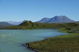
Je souhaiterais faire une boucle au départ de kvikkjokk. En longeant la Kungsleden jusque l'entrée de ravadalen. Je ne suis pas specialement fan des etendues rocheuses mais plutot des vallées verdoyantes, donc j'envisage de remonter la vallée de ravadalen sur la rive ouest jusque la Sarvesvagge puis longer celle ci sur sa rive sud et de bifurquer au sud ouest vers le chemin qui longe la Njoatsosvagge qui me ramènerait à kvikkjokk.
Voilà donc mes questions:
- peut on remonter la ravadalen dans sa partie boisée rive ouest?
- la dernière semaine de septembre est elle encore favorable à la rando dans le sarek?
- conaissez vous un site internet qui me permettrait de planifier mon itineraire en bus de Gallivare à Kvikkjokk?
- où peut on trouver des cartes plus précises que la carte 1/100 000eme dont je dispose déjà ?
Personnellement, je conseillerais de ne pas remonter la Sarvesvagge dans sa partie couverte de bois sans vraiment réfléchir car ça va être une sacrée galère. Hors piste total = chablis à enjamber, végétation à hauteur d'homme voire plus à traverser, hautes herbes masquant les difficultés du terrain, marais parfois profonds, 1 km/h de vitesse moyenne si tout va bien. Il faut en avoir conscience.
Sinon, il est tout à fait possible de remonter la Rapadalen du côté Ouest, j'ai vu des comptes rendus en ce sens et ai vu des randonneurs le faire depuis l'autre rive.
Attention par contre, ceux qui le font partent le plus souvent par Parek, car il y a un chemin marqué et le bas de Rapadalen est truffé de marais et de moustiques. Peut-être pas fin septembre par contre.
J'ai aussi lu que la Gadokjahka pouvait être dangereuse à traverser et qu'il valait mieux prendre le pont mais là encore, cela dépendra des conditions sur place.
Pour la période, il y aura certainement moins d'eau dans les rivières (d'autant plus qu'il a fait très chaud en mai et que la neige devrait déjà être fondue) mais aussi certainement beaucoup moins de transports en commun pour l'accès. Ce sera déjà l'automne, donc les températures seront plus fraîches, il y aura des chutes de neige.
Pas de cartes plus précises que celles disponibles, cette échelle est largement suffisante de toutes façons. Sinon, zoom dans l'atlas en ligne : https://kso.etjanster.lantmateriet.se/
Tu penses que la sarvesvagge est si dense que ca? Ma carte au 1/100k me laisse croire que cette vallée n'est pas tres boisée, mais si c'est le cas, je devrais peut être envisager de la longer de loin par la montagne... l'objectif etant de rejoindre la Njoatsosvagge pour boucler la boucle et rentrer à Kvikkjokk.
Quand tu parles de parek, peux tu me le situer? Sur ma carte parek est au nord de Kvikkjokk juste avant les premiers contreforts de la montagne, mais de là c'est vers la vallée de la Njoatsosvagge que le chemin part... c'est celui que j'envisage de prendre pour finir mon trek.
Si tu sais retrouver les recits que tu as vu sur les gens qui empruntent la rapadalen de l'interieur sur la rive ouest, ca m'intéresse! 😉
Penses tu que je puisse longer la rapadalen au coeur de la vallée, ou faut il la longer de loin?
Est il possible de traverser la rapadalen a gué par endroits?
Il faut se méfier de la carte, la végétation n'a pas l'air très dense mais elle l'est sur le terrain. J'ai pratiqué le hors piste régulièrement en Suède et en Norvège depuis quelques années, je parle d'expérience. Sur la carte, ça a l'air facile, mais en réalité, ça l'est beaucoup moins. Le côté Est est facile car il y a un chemin mais j'ai croisé des personnes qui le trouvaient difficile et il faut bien chercher le tracé parfois.
Oui, le Parek dont je parle est un village same et c'est celui que tu vois sur la carte au nord-est de Kvikkjokk. Ne néglige pas les ponts, lorsqu'ils sont indiqués, c'est qu'ils sont là pour les éleveurs de rennes et que la rivière est un monstre. Attention, certains ne sont installés qu'en été et certains qui sont indiqués sur la carte n'existent plus (celui vers Alggavare Kapell par exemple).
Traverser Rapadalen à pied est possible en face de la Sarvesvagge d'après des récits que j'ai vus, mais uniquement en cas d'eaux très basses et il faut avoir de l'expérience car il y a des sables mouvants. Je te le déconseille franchement car c'est trop aléatoire sans avoir l'expérience du terrain et tes questions montrent que tu ne l'as probablement pas. La longer au coeur de la vallée de ce côté, je ne pense pas, en tout cas pas au début. Trop de marais et trop galère, il faut prendre un peu d'altitude. Mais je ne l'ai pas fait.
Sinon, regarde ce site, c'est une mine d'infos sur le parc : http://www.mior.se/
J'espère que c'est plus clair. Cherche sur le net, il y a beaucoup de ressources et il est possible de traduire en anglais le forum de randonneurs suédois, utsidan.se
Oui effectivement il faut se montrer prudent avec les cartes, je l'ai déjà constaté également... et encore, pour la laponie finlandaise je navigue à la carte 1/50k... c'est pour ca qu'il est toujours bon d'avoir des retours du terrain, ca évite de se retrouver au milieu des tourbières comme je l'ai vécu lors de mon premier trek...
Pour la traversée de la rappadalen, je verrais sur place, ça j'ai l'habitude et j'adapterais mon itinéraire en fonction...
Je vais consulter les liens que tu as posté, ca va me donner du grain à moudre! Et de mon coté j'ai envoyé un mail au centre des visiteurs de kvikkjokk pour connaitre les transports en place à cette saison... bus et bateau...
J'écris ici pour essayer de profiter de vos lumières:-) Je pars en juin pour 18 jours de marche au départ d'Abisko. J'ai vu qu'il est possible de faire une…
Je pars au mois de juillet faire un trek en laponie suédoise qui se déroulera de kvikkjokk à ritsem en totale autonomie. Nous sommes 4 amis et partons en…
Je pars en Suède fin août / début septembre, mes billets d'avion sont déjà réservés: aller le 30/08 pour Stockholm, retour de Stockholm le 18 septembre. Je…
Je me suis donné comme défi de suivre le Padjelantaleden cet été, même si je suis relativement inexpérimentée en trek. Je compte passer les mois suivants à…
Hi,
We’re planning to do the 4-day trek from Mestia to Ushguli without an agency. The descriptions mention that there are accommodations at each stop, but we can’t find any details about them. Has anyone got info or feedback on this route?
We're planning to trek in Peru and Bolivia and would love to find some local agencies.
If you know any, could you share details on prices and, of course, the names of the agencies?
Which trek would you recommend?
Elocine
Je pars en autonomie totale sur un trek au Maroc (10jrs) Imilchil - Aghbalou.
Trouve t-on des cartouches gaz à vis (Coleman, Primus) à Marrakech (adresse) ou villages entre Imilchil - Aghbalou ?
Si non , trouve-t-on des cartouches Butagaz pour camping-gaz (petit volume 230 gr ...)
Merci d' avance pour vos réponses
Hello, I’d like to embark on a little trip in my home country, Switzerland. I’ll start walking from La Cure, heading toward Le Noirmont first, then I’ll improvise my route—but it’ll probably follow the French border... at least as far as Lac de Joux.
I’ll decide day by day how much farther to go after that. My goal is to stay in nature as much as possible, wander around for as long as I can, and restock food in villages or towns along the way.
I’m thinking of mostly camping, but we’ll see if I end up in a hotel or another campsite depending on my route.
I’d love to reach La Chaux-de-Fonds on foot... maybe even Delémont.
The whole thing should take about a week, give or take.
I’ll be bringing my dog, and I’m preparing for this as soon as I’m ready.
Any tips to make sure everything goes smoothly for us? Things I should know—or avoid? What about shepherds with their flocks of sheep? And isn’t hunting season open right now?
I’m not sure if what I’m planning is even doable, which is why I’m asking around.
This’ll be my first time doing something like this—wandering in nature *and* with a dog. I’m really excited for this adventure... and I need it. Thanks!
We’re really keen on ecosystems and want to hike in "natural" ancient forests—not planted woods or areas heavily degraded by human activity. Travel guides (like Lonely Planet) don’t provide much info on this. Could you point us to the most interesting spots?
Thanks in advance for your tips.
We wish you happy holidays and a fantastic 2026, full of discoveries!
Claire and Albert
Hi, this might not be the right section, but I’d like to know if it’s possible to start mountaineering with another person without necessarily hiring a guide. We’ve done quite a bit of hiking but not mountaineering—we’ll just do a half-day glacier course. After that, we were thinking of starting with La Grande Motte and the Pointe de la Traversière, which were recommended to us. Honestly, for things like roping up and knots, I’ll learn at home with lots of videos and a book.
Jaimerais savoir si quelqu'un aurait fait des treks sur le Ruwenzori et combien ça coute en moyenne, les infrastructures, les paysages la sécurité sur les lieux, merci beaucoup. J'attends avec impatience vos réponses.
We’re leaving in 9 days for a two-week trip to Madeira, mainly to hike.
From my research, I’ve found that since last year, access to most trails—and systematically for the most popular ones—is now paid. You have to pay an access fee of 4.50 € per person per classified hike in 2026, and even 10.50 € for the most iconic hike: Pico Arieiro to Pico Ruivo. When paying, you also have to choose a day and a 30-minute time slot for your start time. Of course, this reservation is neither changeable nor refundable, even if the weather that day is terrible.
Personally, given the massive influx of tourists to the island in recent years, I don’t mind paying a fee to help maintain the trails. Similarly, setting a limit on the number of people who can hike them per day is certainly preferable to preserve this priceless heritage.
However, what’s much less fair is that in reality, most of the available spots are reserved: 1/ for Madeira residents (which is normal); 2/ for "economic operators" (meaning local tour operators). For example, if you’re a non-resident (independent tourist), no booking is possible for the Pico Arieiro hike for an early morning start before September! So, unfortunately, we’ll have to skip this hike.
It’s the same issue for Ponta de São Lourenço, the 25 Fontes, Pico Ruivo... in short, all the most popular hikes. Oh well, we’ll skip those too!
So my question is: which hikes do you recommend where we won’t face the huge crowds that the others get? And where we can book the day before for the next day, taking the weather into account?
Finally, a quick accommodation question: we’ve booked the first week in Funchal, but I haven’t decided yet for the second week. Do you have any advice on where to stay in the south or north, preferably avoiding overly concrete-heavy and touristy spots?
I’m reposting about the logistics for Samaria Gorge.
I’d love to get recent info, especially about whether it’s possible to park my car in Omalos, do the hike, and then catch a bus back to my vehicle.
In theory, it’s doable, but when you check the KTEL website, there aren’t any feasible schedules listed. If anyone has recently organized this with reliable, verified details, I’d really appreciate it. Thanks in advance!
Hi there,
We’re flying from Montreal to Lyon this August to go hiking in the French Alps. We’ve rented a car and will be staying at campgrounds. We’re planning to do day hikes and want to stay a few days in one spot, do a few hikes, then move on to our next camping spot. Could you share your favorite spots or any recommendations for places to spend a few days with great hikes?
A few details:
We arrive in early August and leave in early September.
We’re looking for day hikes (or shorter), moderate difficulty, with a cumulative elevation gain of no more than 1000m, and of course, beautiful scenery!
We’d prefer not to drive too much—maybe it’s best not to head too far south and deal with unnecessary heat?
Along the same lines, if you know of any great campgrounds where we can start our hike directly without needing the car, we’d love to hear your suggestions!
Bonjour
Souhaitant faire de la randonnée sur cette île, je voudrais d'abord savoir quelle serait la période la plus favorable sachant que j'avais passé quelques jours en novembre 2018 pas pour cette activité mais plus pour une simple découverte de l'île et le temps n'était pas top notamment en montagne. Donc peut on choisir une organisation en étoile sachant que je louerai un véhicule avec éventuellement 2 points d'hébergement.
Je n'envisage pas d'intégrer une structure mais de partir à 2 et de s'organiser sauf si vous me conseillez une agence locale ou un guide local. Enfin même si je compte me procurer les différents supports, carte et topo guide plus gps je vous remercie de bien vouloir me communiquer les randos à faire en priorité
Merci beaucoup pour vos informations
I’m planning to do the Mercantour crossing following the Randoxygène route in mid-July.
I’m used to hiking in the mountains, but I sometimes get vertigo, for example on ridges with drops on both sides. I wanted to check if there are any T4 or T3-T4 sections and find out if there are any very exposed passages—and if so, where—so I can plan an alternative route.
Can anyone give me some info on this?
Thanks!
I’m planning a trip around Cap Corse and the AGRIATES in 2026, from May 8th to 15th (there are still 2 spots left, by the way! Just DM me if you're interested).
I’d love to know which hikes are worth prioritizing in the AGRIATES. We’ll be staying in SALECCIA for two days as our base—what should we focus on from there?
A round trip to IGNHU beach? Any other suggestions?
For Ostricano, I think it’s too far for a round trip...
Thanks for your tips!
Have a great day,
Anie, Toulouse
I’d like to get some info about the GR10 Pyrenees traverse. I need help planning the daily stages and accommodations—my wife isn’t an experienced hiker but walks a lot, so I’d like to schedule shorter walking days and thus a longer overall trip in terms of number of days.
Could anyone give me some help and advice?
Best regards,
New to this forum, I’m planning a pretty big project for 2028.
I’m heading to Nepal to do a trek from Kathmandu all the way to Everest Base Camp (a cool 5,300 m 😄).
This trek is a bit special because even though I’ll be part of a group, I’m going solo (so far, no problem—I’m used to it). But it’s my first real trek, and it’s also a humanitarian one: once I reach base camp, I’ll stay an extra week to help clean up the waste left by tens of thousands of climbers! Since I’m originally from South America, from two countries that share the Andes, I have a deep respect for mountains—they fascinate me. So Everest… it’s kind of the trip of a lifetime!
So, a little question for those who’ve done treks to Everest before… any tips for good mental preparation (I’m already working on the physical side)?
Hi there, I’m planning the Annapurna Circuit for March 2027 and I’m looking for a local agency with a local guide—preferably French-speaking—to arrange this trek for us. Any suggestions? Thanks
Hello!
We’re spending a few days in Toraja country at the end of May. We’d love to do a day trek—taking our time—on a route that’s stunning in terms of scenery, but not a level 5 in difficulty!
Any suggestions you can share, please?
Thanks in advance
I’d like to do the Mare a Mare Sud in May over 4 days. I’ve found quite a few places to stay along the route, but I’m stuck on the start and finish.
I’ll be arriving by plane on Sunday evening and would like to start pretty early on Monday morning. Ideally, accommodation right at the trailhead (Alzu di Gallina) would be amazing, but I can’t find anything. Any tips?
Also, for the transfer from Figari Airport to Porto Vecchio or Alzu di Gallina?
At the end, I’d like to pick up a rental car—any advice on that too?
I’m traveling solo by plane to Catania in May and plan to hike the northern side of Etna, starting from Linguaglossa where I’ll arrive by bus. After that, I’d love some info on how to get up to Piano Provenzana (shuttles or hitchhiking), since it seems there’s no public transport except in the summer. Can you sleep there in a free or cheap refuge, or camp? And how far up can you go without having to hire a guide? Thanks in advance. Bernard.
Bonjour a tous,
je pars en voyage au Maroc en aout et nous allons commencer par nous arrêter a Chefchaouen(nous sommes en voiture).
Ma question: quelqu'un peut il m'indiquer un itinéraire de rando en boucle d'entre 5 et 7 jours aux départ de Chefchaouen dans le parc de Talassemtane passant si possible par le pont de dieux?Ou un guide papier qui en reunis quelques uns?
Nous privilégions le camping sauvage et les gites.
Merci d'avance
Hi there, for those who’ve been recently—is it possible to find other solo travelers in March on the island to share transport or room costs? It doesn’t seem easy to travel on a budget.
If you have any recommendations for simple lodgings or places with dorms, I’d love to hear them.
For those who’ve done multi-day treks while moving around: do you need to bring your own sleeping bag? I’d love to hear about itineraries you’ve done without a guide, just with a map and GPS.
Thanks, and have a great day!
Hi everyone!
We’re planning a 15-day road trip to Scotland this summer, specifically to explore and hike on Lewis and Harris—places we’ve never been before. We’ve visited other islands on previous road trips in Scotland (we usually go in April for a week). This would be our first time in Scotland in the summer and for 15 days. We’re looking at late August to early September.
I’m currently drafting the itinerary. We’d be crossing from Ullapool and were thinking of spending 3 nights on Harris and 4 nights on Lewis.
Does that sound balanced to you? Is it better to keep the same accommodation on Harris and the same on Lewis to explore the area? I’d love to hear about any past experiences you’ve had on these islands.
Thanks!
Hi there, I’m trying to leave for 15 days very soon to São Vicente. I’m either looking to join an agency or figure things out on my own to go hiking on one of these islands or both. From what I’ve seen, it’s not easy to organize with local transport, so it gets expensive. Can I use the services of a small local agency? I’m looking for the simplest way to hike for several days. Also, how do you get from São Vicente to São Nicolau? Thanks in advance and have a great day!
Aichatou
I’ve been wanting to do this for several years, and this year’s the one. Next September, I’ll be trekking in Tusheti (Georgia), from Omalo to Shatili.
Of course, I won’t be renting a vehicle that’d just sit unused. No problem getting to Pshaveli, but from there to Omalo, it’s a dirt road (still the case?)
There must be some form of public transport since there are so many guesthouses, and not all travelers come in a 4x4.
If any of you have been to Omalo, could you confirm that these shared transports exist and how often they run?
we’re planning a trip to Yellowstone and hoping to do a three-day backcountry hike if we get a permit.
if any of you have done this before, could you let me know if it’s possible to find water along the way? And if we can transport it, are we allowed to use a stove?
Hello,
I’ll be in Nepal from March 6th to 29th (we’re flying into Kathmandu via Varanasi and leaving via Delhi).
I’m a bit confused about the regulations requiring a guide.
My wife and I (we’re 63 and 64) aren’t experienced trekkers—we’re more used to walking on terrain with very moderate elevation changes. I’m looking for fairly easy hikes, possibly day trips.
Here are my questions:
- Does the Poon Hill trek from Pokhara require a guide, or is it better to go through a local agency? (I’ve seen a lot of them offering 4-day packages)
- I’d like to do a few multi-day hikes around Jomsom (Kagbeni, Mukitinath, Lupra, Marpha)... Do you need a guide for those, and can you find accommodations easily without booking in advance?
Last question—I’m really hesitant to lug around a sleeping bag or down jacket during our 6 weeks in India. Can you easily find these kinds of items at reasonable prices in Pokhara?
Thanks in advance for any tips you can share!
Yann
I’m a 56-year-old man who’s done several treks in Nepal and elsewhere. Also passionate about photography.
I’m looking for one or more people to form a group for a trek in Nepal. The trek is the Annapurna and Manaslu circuit (24 days), including a stop at Tilicho Lake. I’ve got a great itinerary and the local company seems solid. The price is around $1600.
I’ll be in Nepal from April 5 to May 12, 2026, so the trek would need to happen within those dates.