Bonjour,
Nous partons en cet été en Norvège pour 1mois. De Stavanger aux iles Lofoten. Nous souhaitons faire un maximum de randonnées.
Quelles sont les randonnées à faire absolument? Quelle à été votre plus expérience en Norvège?
Jotunheimen est un bon parc pour une rando de plusieurs jours.
Pour des ballades plus courtes, la plus belle peut etre cote Sud de Geiranger, il y en a une autre cote Nord
Quelles sont les randonnées à faire absolument? Quelle à été votre plus expérience en Norvège?
Ce serait trop long de tout détailler. Je te renvoie à notre récit de voyage, du sud du pays jusqu'aux îles Lofoten, avec des randonnées à la journée tous les jours ou presque.
sites.google.com/...uleuxvoyagesnorvege/
Deux sites pour trouver des randos (mais il faut fouiller et sélectionner)
- dans tout le pays : www.ut.no/
- spécifiquement dans les Lofoten (il faut s'inscrire pour accéder aux topos) : rando-lofoten.net/index.php/fr/
Bonjour,
Je connais quelques itinéraires de randonnée les plus préférés en Norvège :
-Soleil de minuit aux Lofoten
-Les îles Lofoten
-Les Lofoten d’île en île
-La magie des fjords
Bonjour,
Nous partons en cet été en Norvège pour 1mois. De Stavanger aux iles Lofoten. Nous souhaitons faire un maximum de randonnées.
Quelles sont les randonnées à faire absolument? Quelle à été votre plus expérience en Norvège?
Merci pour votre aide 🙂
Bonjour,
Sur mon site, j'ai des topos sur des randos de plein de coin différents en Norvège : trek.uniterre.com/norvege/, dont 17 topos détaillé de balades aux Lofoten.
Mon top 5 des randos à la journée en Norvège :
- Munkan, Geitgaljen, Kjergabolten, Preikstolen, Trolltunga
Les plus beaux treks (> 3 jours) :
- Jotunheim (fait en partie seulement) et le Dovrefjell
Pour des topos de treks et des informations précises sur les pays que j'ai visités, rendez-vous sur mon blog : https://treketvoyages.com/.
Il fonctionne comme un modeste guide de voyage et non comme un récit de voyage.
Bonjour et merci pour vos réponses et tous ces sites.
Pourriez vous me donner plus de renseignements sur Geiranger - Skagelfa? J'ai lu qu'il était possible de faire l'A ou le R en bateau. Est il préférable de l'aller ou le retour? ou se trouve les début de la randonnée? est elle "fléchée"?
🙂
Pourriez vous me donner plus de renseignements sur Geiranger - Skagelfa? J'ai lu qu'il était possible de faire l'A ou le R en bateau. Est il préférable de l'aller ou le retour? ou se trouve les début de la randonnée? est elle "fléchée"?
Le début de la randonnée (côté Est) est à Homlong. A l'extrémité Ouest, il est à... Skagefla (Skagehola) comme le montre cette carte (carte extraite du site ut.no, précédemment recommandé 😉). Le sentier est balisé.
Oui, on pouvait faire une partie en bateau mais je ne sais pas si c'est toujours possible. Nous avons fait la rando en aller/retour depuis Homlong et jusqu'aux fermes de Homlongsetra uniquement.
Voir ici et pour les détails explorer la carte Google en bas de page
sites.google.com/...yagesnorvege/homlong
Voir aussi le document de l'office de tourisme de Geiranger qui répertorie tous les sentiers du coin :
Cette image laisse à penser que, dans le cas d'un aller simple, le sens Homlong - Skagehola soit plus facile que le contraire (montée +++).
Dans le cas d'un AR, le plus intéressant est d'aller de Homlong jusqu'au point de vue indiqué un peu après Homlongsetra. A mon avis, inutile d'aller jusqu'au niveau du fjord (Skagehola) car au retour il faudrait se farcir une sacrée montée.
Bonjour, pour les randonnées au Lofoten ce site est génial, nous avons fait toute nos randonnée par rapport à ce site. Il propose des fichier gtx pour chacune des randonnée.
Nous avons fait Moltinden, Trolldastinden, Kleppstadheia, Matmora (sur 2 jours)
Toutes superbes ;)
N'hésitez pas à passer par le musée viking sur l'île de vestvagoy.
Merci Krikri pour le site de randonnées: www. ut.no
Je ne connaissais pas. Ca va me permettre de compléter mes recherches.
Ravie que mes infos aient été utiles à quelqu'un ! 🙂
ut.no est très riche, je m'en étais déjà pas mal servi en 2014, et encore plus cette année pour notre prochain séjour.
Je viens de prendre connaissance de votre message sur la rando de Skagelfa a Geiranger , je l'ai faîte sans prendre le bateau , le bateau c'est un peu de l'arnaque .
le plus difficile c'est de trouver une place pour garer la voiture au niveau du camping d'Homlong .Compter 3 h30 AR en marchant bien si vous descendez jusqu'aux fermes.
On se croisera peut être je repars cette année 6 semaines avec ma voiture , Bretagne-Danemark-Kristiansand-Odda-Lofoten-Olden-Stavanger-Kristiansand-Bretagne.
Bonjour Despereti,
En Norvège compte d’innombrables possibilités de randonnées. Les randonnées préférées sont:
-Aurlandsdalen : randonnée historique de 4 jours sur les traces d’anciennes routes commerciales entre Geiteryggen et Aurland.
-Parc national de Saltfjellet-Svartisen: Des itinéraires à l’atmosphère spectaculairement arctique, entre calottes glaciaires et plateaux pelés.
-Plateau de la Hardangervidda: Ce splendide plateau, territoire des rennes est quadrillé d’innombrables sentiers.
-Parc national de Stabbursdalen: Aucune route, mais des sentiers traversant des canyons glaciaires et la forêt de pins la plus septentrionale du monde.
-
Bon voyage!
Concernant une randonnée en Norvège en été, j’ai quelques conseils:
-Chaussures : vous devriez apporter de solides chaussures de marche.
-Vêtements : Des vêtements chauds, dont une veste, un pull, un anorak ou un coupe-vent.
-D’autres choses: Un drap ou « sac à viande », une tente légère mais solide, l’antimoustique, un petit réchaud, un masque de sommeil, pour les nuits d’été sans obscurité, une bonne carte topographique.
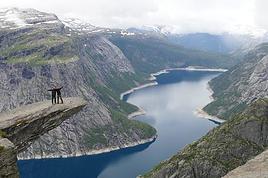
Les randos que j'ai préférées : le Trolltunga, la crête de Besseggen et le Preikestolen. Mes expériences les plus magiques ne sont pas des randos mais des routes : l'ancienne Strynefjell et Aursjøvegen road :)
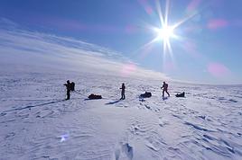
Petit debrief de mon séjour en Norvège (4 jours Oslo + 4 jours trek).
J'avais choisi de marcher à travers Rondane Nasjonalpark, notamment parce qu'il est moins fréquenté que Jotunheimen et Dovrefjell, et aussi parce la météo y est souvent plus clémente (climat plus sec).
En 4 jours j'ai été de Otta, au sud-ouest du parc, jusqu'à Hjerkinn au Nord. Ces 2 localités sont accessibles en train. Le trajet Oslo-Otta (3h30) m'a couté à peu près 500 NOK, mais j'ai réservé tard. On peut trouver des billets à la moitié de ce prix. Le retour Hjerkinn-Oslo pour le même prix (5h).
De la gare de Otta il y a un bus qui amène à l'entrée du parc de Rondane (parking de Spranget) pour 37 NOK. 1h de trajet et ça grimpe ! A pied il faut 1/2 journée à une journée de marche.
J'ai donc commencé à marcher le lundi à 13h, de puis Spranget, pour arriver à Hjerkinn le jeudi après-midi. L'avantage en juillet en Norvège c'est qu'il fait jour jusqu'à minuit, donc on peut marcher tard... Par contre il refait jour à 4h du matin, donc les nuits sous la tente sont courtes !
J'ai eu une averse le premier jour, idem le 2e avec en plus un vent fort et froid toute la journée (la plus mauvaise journée). Les 2 derniers jours alternance de ciel voilé et de soleil. Beaucoup de vent sur la traversée du plateau de Dovre (heureusement je l'avais dans le dos).
A cause d'un bobo au genou j'ai raccourci mon projet initial. Ma 3e étape fut donc assez courte.
Le fichier kml de mon parcours :
Le long du parcours j'ai croisé quelques randonneurs, tous norvégiens, mais peu de monde au total. Dans le train et à Oslo j'ai rencontré pas mal de trekkeurs étrangers (notamment français), tous allaient à Jotunheimen ou Dovrefjell.
Ma seule déception est de na pas avoir vu de vie sauvage, à part quelques oiseaux. Les rennes sont très timides et en été ils partent se cacher loin, loin, loin...
Par la fenêtre du train au retour j'ai aperçu plusieurs élans (=orignaux).
« Ne soyons plus anglais ni français ni allemands. Soyons européens. Ne soyons plus européens, soyons hommes. - Soyons l'humanité. Il nous reste à abdiquer un dernier égoïsme : la patrie. » Victor Hugo
« Ne soyons plus anglais ni français ni allemands. Soyons européens. Ne soyons plus européens, soyons hommes. - Soyons l'humanité. Il nous reste à abdiquer un dernier égoïsme : la patrie. » Victor Hugo
j'ai oublié de précisé que nous avons effectué le tour du Jotuheimen" départ Gjendesheim arrivée Gjendesheim " puis dans la foulée direction Forset à 30 kms de Lillehammer ,214kms en 15 jours à pied .Nous avons eu la chance de rencontrer plusieurs fois des troupeaux de rennes Ce sont des animaux magnifiques à regarder , je ne m'en lasse pas
Je n'ai fais que le sommet Galdhopiggen seul , mon épouse etant restait au bivouac à 1 km du camping .Pour la suite , nous avons pris la variante pour le refuge Glittertinden .Un bon km avant d'arriver au refuge troupeau de rennes
Avec ma femme, nous visitons la Norvège le printemps/été prochain. Avez vous des idées de randonnée sympa à la journée, max 8h * Période: mi mai à fin juin *…
Besoin de vos lumières sur un pays méconnu: la Norvège. En tirant des papiers au sort dans un saladier j'ai offert à un ami un billet aller retour en Norvège à…
Je m'apprête à partir en Norvège pour plusieurs mois. Je ne prévois pas de camper, régulièrement, mais j'emporte un sac de couchage et un sur-sac au cas où,…
J'aimerais partir en mai ou juin en Norvège avec comme but les Lofoten. J'aimerais me déplacer sans voiture (ou pourquoi pas en stop) et axer le séjour…
Nous sommes une famille de 5 avec 3 enfants d’une dizaine d’annees. Nous projetions d’aller sur les îles Lofoten en Avril 2020. Comme vous y êtes partis quel…
Bonjour,
Nous souhaitons faire le trek de 4 jours reliant Mestia à Ushguli sans agence. Il est précisé dans les descriptifs qu'il existe des hébergement à chaque étape, mais on ne trouve pas d'info sur ces hébergements. Quelqu'un a-t-il des infos et un avis sur ce parcours?
We're planning to trek in Peru and Bolivia and would love to find some local agencies.
If you know any, could you share details on prices and, of course, the names of the agencies?
Which trek would you recommend?
Elocine
Je pars en autonomie totale sur un trek au Maroc (10jrs) Imilchil - Aghbalou.
Trouve t-on des cartouches gaz à vis (Coleman, Primus) à Marrakech (adresse) ou villages entre Imilchil - Aghbalou ?
Si non , trouve-t-on des cartouches Butagaz pour camping-gaz (petit volume 230 gr ...)
Merci d' avance pour vos réponses
Hello, I’d like to embark on a little trip in my home country, Switzerland. I’ll start walking from La Cure, heading toward Le Noirmont first, then I’ll improvise my route—but it’ll probably follow the French border... at least as far as Lac de Joux.
I’ll decide day by day how much farther to go after that. My goal is to stay in nature as much as possible, wander around for as long as I can, and restock food in villages or towns along the way.
I’m thinking of mostly camping, but we’ll see if I end up in a hotel or another campsite depending on my route.
I’d love to reach La Chaux-de-Fonds on foot... maybe even Delémont.
The whole thing should take about a week, give or take.
I’ll be bringing my dog, and I’m preparing for this as soon as I’m ready.
Any tips to make sure everything goes smoothly for us? Things I should know—or avoid? What about shepherds with their flocks of sheep? And isn’t hunting season open right now?
I’m not sure if what I’m planning is even doable, which is why I’m asking around.
This’ll be my first time doing something like this—wandering in nature *and* with a dog. I’m really excited for this adventure... and I need it. Thanks!
We’re really keen on ecosystems and want to hike in "natural" ancient forests—not planted woods or areas heavily degraded by human activity. Travel guides (like Lonely Planet) don’t provide much info on this. Could you point us to the most interesting spots?
Thanks in advance for your tips.
We wish you happy holidays and a fantastic 2026, full of discoveries!
Claire and Albert
Hi, this might not be the right section, but I’d like to know if it’s possible to start mountaineering with another person without necessarily hiring a guide. We’ve done quite a bit of hiking but not mountaineering—we’ll just do a half-day glacier course. After that, we were thinking of starting with La Grande Motte and the Pointe de la Traversière, which were recommended to us. Honestly, for things like roping up and knots, I’ll learn at home with lots of videos and a book.
Hi,
I don’t know Switzerland at all and was wondering if Vallée des Joux and especially Dent de Vaulion are packed early in the morning or late in the afternoon in July and September?
If so, do you have any quieter spots to recommend in the area, or in Luxembourg (yes, I know it’s not the same country 😉)?
Thanks a lot!
Jaimerais savoir si quelqu'un aurait fait des treks sur le Ruwenzori et combien ça coute en moyenne, les infrastructures, les paysages la sécurité sur les lieux, merci beaucoup. J'attends avec impatience vos réponses.
We’re leaving in 9 days for a two-week trip to Madeira, mainly to hike.
From my research, I’ve found that since last year, access to most trails—and systematically for the most popular ones—is now paid. You have to pay an access fee of 4.50 € per person per classified hike in 2026, and even 10.50 € for the most iconic hike: Pico Arieiro to Pico Ruivo. When paying, you also have to choose a day and a 30-minute time slot for your start time. Of course, this reservation is neither changeable nor refundable, even if the weather that day is terrible.
Personally, given the massive influx of tourists to the island in recent years, I don’t mind paying a fee to help maintain the trails. Similarly, setting a limit on the number of people who can hike them per day is certainly preferable to preserve this priceless heritage.
However, what’s much less fair is that in reality, most of the available spots are reserved: 1/ for Madeira residents (which is normal); 2/ for "economic operators" (meaning local tour operators). For example, if you’re a non-resident (independent tourist), no booking is possible for the Pico Arieiro hike for an early morning start before September! So, unfortunately, we’ll have to skip this hike.
It’s the same issue for Ponta de São Lourenço, the 25 Fontes, Pico Ruivo... in short, all the most popular hikes. Oh well, we’ll skip those too!
So my question is: which hikes do you recommend where we won’t face the huge crowds that the others get? And where we can book the day before for the next day, taking the weather into account?
Finally, a quick accommodation question: we’ve booked the first week in Funchal, but I haven’t decided yet for the second week. Do you have any advice on where to stay in the south or north, preferably avoiding overly concrete-heavy and touristy spots?
I’m reposting about the logistics for Samaria Gorge.
I’d love to get recent info, especially about whether it’s possible to park my car in Omalos, do the hike, and then catch a bus back to my vehicle.
In theory, it’s doable, but when you check the KTEL website, there aren’t any feasible schedules listed. If anyone has recently organized this with reliable, verified details, I’d really appreciate it. Thanks in advance!
Hi there,
We’re flying from Montreal to Lyon this August to go hiking in the French Alps. We’ve rented a car and will be staying at campgrounds. We’re planning to do day hikes and want to stay a few days in one spot, do a few hikes, then move on to our next camping spot. Could you share your favorite spots or any recommendations for places to spend a few days with great hikes?
A few details:
We arrive in early August and leave in early September.
We’re looking for day hikes (or shorter), moderate difficulty, with a cumulative elevation gain of no more than 1000m, and of course, beautiful scenery!
We’d prefer not to drive too much—maybe it’s best not to head too far south and deal with unnecessary heat?
Along the same lines, if you know of any great campgrounds where we can start our hike directly without needing the car, we’d love to hear your suggestions!
Bonjour
Souhaitant faire de la randonnée sur cette île, je voudrais d'abord savoir quelle serait la période la plus favorable sachant que j'avais passé quelques jours en novembre 2018 pas pour cette activité mais plus pour une simple découverte de l'île et le temps n'était pas top notamment en montagne. Donc peut on choisir une organisation en étoile sachant que je louerai un véhicule avec éventuellement 2 points d'hébergement.
Je n'envisage pas d'intégrer une structure mais de partir à 2 et de s'organiser sauf si vous me conseillez une agence locale ou un guide local. Enfin même si je compte me procurer les différents supports, carte et topo guide plus gps je vous remercie de bien vouloir me communiquer les randos à faire en priorité
Merci beaucoup pour vos informations
I’m planning to do the Mercantour crossing following the Randoxygène route in mid-July.
I’m used to hiking in the mountains, but I sometimes get vertigo, for example on ridges with drops on both sides. I wanted to check if there are any T4 or T3-T4 sections and find out if there are any very exposed passages—and if so, where—so I can plan an alternative route.
Can anyone give me some info on this?
Thanks!
I’m planning a trip around Cap Corse and the AGRIATES in 2026, from May 8th to 15th (there are still 2 spots left, by the way! Just DM me if you're interested).
I’d love to know which hikes are worth prioritizing in the AGRIATES. We’ll be staying in SALECCIA for two days as our base—what should we focus on from there?
A round trip to IGNHU beach? Any other suggestions?
For Ostricano, I think it’s too far for a round trip...
Thanks for your tips!
Have a great day,
Anie, Toulouse
I’d like to get some info about the GR10 Pyrenees traverse. I need help planning the daily stages and accommodations—my wife isn’t an experienced hiker but walks a lot, so I’d like to schedule shorter walking days and thus a longer overall trip in terms of number of days.
Could anyone give me some help and advice?
Best regards,
New to this forum, I’m planning a pretty big project for 2028.
I’m heading to Nepal to do a trek from Kathmandu all the way to Everest Base Camp (a cool 5,300 m 😄).
This trek is a bit special because even though I’ll be part of a group, I’m going solo (so far, no problem—I’m used to it). But it’s my first real trek, and it’s also a humanitarian one: once I reach base camp, I’ll stay an extra week to help clean up the waste left by tens of thousands of climbers! Since I’m originally from South America, from two countries that share the Andes, I have a deep respect for mountains—they fascinate me. So Everest… it’s kind of the trip of a lifetime!
So, a little question for those who’ve done treks to Everest before… any tips for good mental preparation (I’m already working on the physical side)?
Hi there, I’m planning the Annapurna Circuit for March 2027 and I’m looking for a local agency with a local guide—preferably French-speaking—to arrange this trek for us. Any suggestions? Thanks
Hello!
We’re spending a few days in Toraja country at the end of May. We’d love to do a day trek—taking our time—on a route that’s stunning in terms of scenery, but not a level 5 in difficulty!
Any suggestions you can share, please?
Thanks in advance
I’d like to do the Mare a Mare Sud in May over 4 days. I’ve found quite a few places to stay along the route, but I’m stuck on the start and finish.
I’ll be arriving by plane on Sunday evening and would like to start pretty early on Monday morning. Ideally, accommodation right at the trailhead (Alzu di Gallina) would be amazing, but I can’t find anything. Any tips?
Also, for the transfer from Figari Airport to Porto Vecchio or Alzu di Gallina?
At the end, I’d like to pick up a rental car—any advice on that too?
I’m traveling solo by plane to Catania in May and plan to hike the northern side of Etna, starting from Linguaglossa where I’ll arrive by bus. After that, I’d love some info on how to get up to Piano Provenzana (shuttles or hitchhiking), since it seems there’s no public transport except in the summer. Can you sleep there in a free or cheap refuge, or camp? And how far up can you go without having to hire a guide? Thanks in advance. Bernard.
Bonjour a tous,
je pars en voyage au Maroc en aout et nous allons commencer par nous arrêter a Chefchaouen(nous sommes en voiture).
Ma question: quelqu'un peut il m'indiquer un itinéraire de rando en boucle d'entre 5 et 7 jours aux départ de Chefchaouen dans le parc de Talassemtane passant si possible par le pont de dieux?Ou un guide papier qui en reunis quelques uns?
Nous privilégions le camping sauvage et les gites.
Merci d'avance
Hi there, for those who’ve been recently—is it possible to find other solo travelers in March on the island to share transport or room costs? It doesn’t seem easy to travel on a budget.
If you have any recommendations for simple lodgings or places with dorms, I’d love to hear them.
For those who’ve done multi-day treks while moving around: do you need to bring your own sleeping bag? I’d love to hear about itineraries you’ve done without a guide, just with a map and GPS.
Thanks, and have a great day!
Hi everyone!
We’re planning a 15-day road trip to Scotland this summer, specifically to explore and hike on Lewis and Harris—places we’ve never been before. We’ve visited other islands on previous road trips in Scotland (we usually go in April for a week). This would be our first time in Scotland in the summer and for 15 days. We’re looking at late August to early September.
I’m currently drafting the itinerary. We’d be crossing from Ullapool and were thinking of spending 3 nights on Harris and 4 nights on Lewis.
Does that sound balanced to you? Is it better to keep the same accommodation on Harris and the same on Lewis to explore the area? I’d love to hear about any past experiences you’ve had on these islands.
Thanks!
Hi there, I’m trying to leave for 15 days very soon to São Vicente. I’m either looking to join an agency or figure things out on my own to go hiking on one of these islands or both. From what I’ve seen, it’s not easy to organize with local transport, so it gets expensive. Can I use the services of a small local agency? I’m looking for the simplest way to hike for several days. Also, how do you get from São Vicente to São Nicolau? Thanks in advance and have a great day!
Aichatou
I’ve been wanting to do this for several years, and this year’s the one. Next September, I’ll be trekking in Tusheti (Georgia), from Omalo to Shatili.
Of course, I won’t be renting a vehicle that’d just sit unused. No problem getting to Pshaveli, but from there to Omalo, it’s a dirt road (still the case?)
There must be some form of public transport since there are so many guesthouses, and not all travelers come in a 4x4.
If any of you have been to Omalo, could you confirm that these shared transports exist and how often they run?
we’re planning a trip to Yellowstone and hoping to do a three-day backcountry hike if we get a permit.
if any of you have done this before, could you let me know if it’s possible to find water along the way? And if we can transport it, are we allowed to use a stove?
Hello,
I’ll be in Nepal from March 6th to 29th (we’re flying into Kathmandu via Varanasi and leaving via Delhi).
I’m a bit confused about the regulations requiring a guide.
My wife and I (we’re 63 and 64) aren’t experienced trekkers—we’re more used to walking on terrain with very moderate elevation changes. I’m looking for fairly easy hikes, possibly day trips.
Here are my questions:
- Does the Poon Hill trek from Pokhara require a guide, or is it better to go through a local agency? (I’ve seen a lot of them offering 4-day packages)
- I’d like to do a few multi-day hikes around Jomsom (Kagbeni, Mukitinath, Lupra, Marpha)... Do you need a guide for those, and can you find accommodations easily without booking in advance?
Last question—I’m really hesitant to lug around a sleeping bag or down jacket during our 6 weeks in India. Can you easily find these kinds of items at reasonable prices in Pokhara?
Thanks in advance for any tips you can share!
Yann