Avez-vous deja teste des routes realise par Adventure Cycling-Route ?
A quoi cela ressemble ? c'est des routes pour cyclo confirme ou pour tout le monde ?
Et je cherche des avis sur Great Rivers South plus particulierement ?
D'avance merci,
Guillaume
Ps: je suis sur un clavier qwerty donc pas d'accent possible.
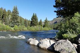
J'ai utilisé les cartes de l'Adventure Cycling Association lors de mes deux voyages de la "Pacific Coast" (Vancouver-San Diego)
J'ai bien apprécié ces cartes pour les renseignements utiles qu'elles fournissent. Bon nombre de cyclotouristes rencontrés les utilisaient.
Est-ce des routes pour cyclistes confirmés ou pour tout le monde ?
Difficile de répondre d'une manière catégorique. Différents éléments peuvent influencer le degré de difficulté d'un parcours:
- La saison où sera fait le voyage. (Par exemple, faire le Southern Tier pendant l'été est passablement plus difficile que le faire pendant une autre saison.)
- Le sens dans lequel il serait fait: Pour la "Pacific Coast" la direction nord-sud était exigeait beaucoup moins d'effort, compte tenu des vents dominants.
- Le relief de la route, qui peut varier passablement d'un choix de route à l'autre.
- L'infrastructure touristique (camping, hébergement en général) qui peut varier d'une région à l'autre.
Toutefois, je pense qu'en général, ces cartes sont faites pour le cyclotouriste moyen.
En choisissant la bonne saison, la bonne direction (si cela s'applique), et surtout le bon rythme, les chances de succès devraient être excellentes.
Avez-vous deja teste des routes realise par Adventure Cycling-Route ?
A quoi cela ressemble ? c'est des routes pour cyclo confirme ou pour tout le monde ?..
Lors de notre traversée des USA en 2014 (9,300 km d'est en ouest, à travers le Vermont, NY, Ontario, Michigan incluant Upper Peninsula, Wisconsin, Minnesota, Iowa, South Dakota, Wyoming, Montana, Idaho, Washington, Oregon), nous avons préféré choisir nos propres trajets, en privilégiant davantage les routes tranquilles et en tentant de relier les National Parks et autres endroits intéressants.
Nous connaissions en partie certaines sections de American Cyclist Association pour y avoir déjà rouler en d'autres occasions, notamment la route 9N qui suit plus ou moins la Hudson River entre Plattsburgh, Albany et NY. Notre constat sur cette section étant que des alternatives plus intéressantes (plus scéniques, moins achalandées) sont possibles en ayant une bonne connaissance du terrain localement, par exemple par le biais de cyclistes locaux (via le réseau warmshowers.org ou autrement).
Cela requiert évidemment davantage de recherches et implique aussi que les trajets pourront être à l'occasion moins linéaires, par exemple pour certains détours incontournables.
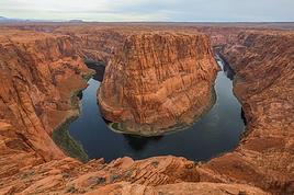
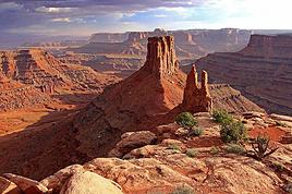
A titre d'exemple, les Finger Lakes (au sud du Lac Ontario), Sleeping Bear State Park (au nord du Michigan), Pictured Rocks (au sud du Lac Supérieur, près de Marquette), Badlands National Park (entre Pine Ridge Indian Reservation et Rapid City, au South Dakota), les Black Hills au South Dakota (Mont Rushmore, Pigtails Highway, CrazyHorse Monument), le Massif des Bighorn (au Wyoming), BearTooth Highway (entre le Wyoming et le Montana, entrée nord de Yellowstone), Missouri River Headwaters State Park (au Montana) , North Cascades Highway (Sherman Pass, Loup Loup Pass, Washington Pass, au nord de l'Etat de Washington) sont toutes des merveilles que nous n'aurions jamais soupçonné en suivant aveuglément les routes standardisées par American Cyclist Association.
J'en conclus aux avantages et inconvénients suivants
Avantages des trajets de l'American Cyclist Association:
- peu de préparation requise dans la planification du trajet
- Documentation complète et détaillée. Diminution des risques en cas de problèmes.
- Trajets généralement plus courts, davantage de type "point A à point B", utilisant les voies les plus directes (moins de détours, etc)
- Ces routes étant largement diffusées et utilisées par beaucoup de cyclistes voyageant aux USA, vous aurez plus de probabilités de croiser d'autres voyageurs ou de partager des bouts de trajets avec eux.
Inconvénients (selon notre expérience)
- routes parfois plus achalandées (ex: route 9N dans l'Etat de NY), alors que des alternatives locales plus intéressantes ne sont pas exploitées
- Les monuments historiques, sites naturels, parcs nationaux, routes panoramiques ne sont pas tous exploités par les tracés respectifs (ce qui, néanmoins, est compréhensible!).
- En ayant un plan de route "encadré", le voyageur est moins enclin à profiter des recommandations de cyclistes locaux, pour éviter de trop sortir du trajet principal.
- Les hôtes du Réseau warmshowers.org qui sont à proximité des routes nationales de l'American Cyclist Association sont souvent très sollicités. A Seaside en Oregon, l'hôte local héberge une cinquantaine de cyclistes par année! De la "visite" à chaque semaine, à l'année!!! En fréquentant des hôtes moins sollicités, vous bénéficierez d'un accueil moins désabusé et d'une plus grande disponibilité, et de meilleures chances d'être hébergés.
Bonjour, Je deterre ce post pour savoir si ce réseau de route possède des panneaux d'indication sur le bord de la route ? Ou est ce seulement un réseau de points gps (une trace) ? merci
Bonjour, Je deterre ce post pour savoir si ce réseau de route possède des panneaux d'indication sur le bord de la route ? Ou est ce seulement un réseau de points gps (une trace) ? merci
Bonjour David,
Depuis notre traversée américaine de 2014 d'est en ouest (de Beloeil au Québec, près de Montréal, à Seaside, Oregon, sur la Côte du Pacifique), nous avons fait une nouvelle traversée, cette fois du nord au sud le long de la côte ouest (Washington, Oregon et Californie, à l'automne 2016).
Nous avions aussi fait à l'automne 2013 une première traversée nord-sud, essentiellement dans l'est du pays, notamment à travers les états du Vermont, NH, Massachussetts, New York, Virginie, Carolines (2), Georgie et Floride jusqu'à Key West.
Bien que les trajets de l'American Cyclist Association soient superbement documentées par des cartes papier et livrets associés, je ne me souviens pas d'avoir vu nulle part des panneaux d'indication de leurs trajets.
@rikimiki Ok merci. Sur leur site on voit un panneau qui ressemble a nos panneaux de pistes cyclables alors j'me posais la question. Je me lance pour un San Fransisco/Colombie britanique fin mars en espérant que la neige de la Sierra Nevada aura fondue ! 3 traversées des U.S. vous êtes un peu des vétérans.. J ai donc une question à vous poser : Les bibliothèques municipales aux U.S. sont t'elle facilement accessibles pour les cyclo voyageurs. Peut t'on y faire hâlte, bouquiner, recharger une tablette et consulter ses mails par exemple ?
Merci
... J ai donc une question à vous poser : Les bibliothèques municipales aux U.S. sont t'elle facilement accessibles pour les cyclo voyageurs. Peut t'on y faire hâlte, bouquiner, recharger une tablette et consulter ses mails par exemple ?
Merci
Sur ce point je ne pourrai pas vous aider formellement, car nous n'avons pas fréquenté ces bibliothèques au fil de nos voyages, sauf pour visiter leurs cachets architecturaux, comme à Boston et à Quito. Néanmoins, votre hypothèse me semble juste; Vous devriez avoir partout un accès Internet temporaire et la possibilité d'y recharger vos appareils.
Pour notre part, nous avions un accès Internet via un fournisseur 3G américain, pour nous essentiel à la planification et aux contacts locaux. Utilisant le réseau Warmshowers.org, ça nous suffisaient pour la recharge des appareils, en complément d'un panneau solaire et de batteries de recharge.
Bon voyage à vélo avec votre fils. Une belle épopée vous attends!
Fin Mars ! C’est un peu tôt. Bonne chance avec la météo.
Oui il y a des panneaux de balisages pour les cyclistes mais avoir une carte, un gps ou le livre Bicycling the Pacific Coast est fortement conseillé.
Les bibliothèques sont des très bons spots pour avoir du wifi gratuit. Sinon il y a les fast foods.
Des infos sur mon site. Lien dans ma signature
:) Je compte les heures qui me sépare du départ. Je n'en peux plus d'attendre depuis Noël déjà. Le voyage est vraiment une drogue... Votre prochain trip ?
Nous reprenons aussi la route très bientôt au début avril. Auparavant, nous ferons 10 jours en refuges dans le Massif des Chics-Chocs en Gaspésie, une expédition de ski nordique et télémark.
Donc départ à vélo le 10 avril depuis Athènes;
Grèce (1er mois: Péloponnèse, Kithira, Crête, Rhodes)
Turquie: 2e mois
Balkans (3e mois: Bulgarie, Macédoine, Kosovo, Serbie, Bosnie-Herzégonine, Croatie)
derniers 3 mois: Slovénie Autriche, Italie, Suisse, Allemagne, France
Pas de moyen facile pour vivre plus de 3 mois en Europe de l'Ouest (ça prend un visa longue durée pour les pays de l'espace Schengen, compliqué à obtenir, résultat incertain ...).
Solution retenue: changer le trajet!
planificateur.a-contresens.net/itineraire/175045
voir aussi nos blogs:
www.crazyguyonabike.com/directory/…
et
tandemetcie.com
cool ! Voici ma localisation warmshowers si vous poussez jusqu'à l'Atlantique. y a de la place pour un tandem dans le jardin lat : 45.900641 long : -0.918721
On a fait un mois en Turquie en 2013 j'ai adoré : http://europetour2013.canalblog.com
A+ j'éspère . Have a safe trip
@Tioneb Oui je sais que c'est un peu tôt dans la saison. Mais j'avais plusieurs paramètres à prendre en compte et c'était le meilleur créneau ( j'éspère). Je suis l'évolution de la situation des routes sur le site california transportation qui donne la situation en temps réelle. C'est pas encore top mais ça se dégage un peu... Le relief autour du Lac Taho c'est raide raide ou juste raide ?
@rikimiki Ok merci. Sur leur site on voit un panneau qui ressemble a nos panneaux de pistes cyclables alors j'me posais la question. Je me lance pour un San Fransisco/Colombie britanique fin mars en espérant que la neige de la Sierra Nevada aura fondue ! 3 traversées des U.S. vous êtes un peu des vétérans.. J ai donc une question à vous poser : Les bibliothèques municipales aux U.S. sont t'elle facilement accessibles pour les cyclo voyageurs. Peut t'on y faire hâlte, bouquiner, recharger une tablette et consulter ses mails par exemple ?
Merci
Oui, les bibliotheques sont normalement facilement accessibles aux USA.
Helas, c'est un hiver avec beaucoup plus de pluie et neige en Californie que normal. Je crois que cette annee, le col Tioga Pass a Yosemite ne s'ouvrira pas avant juin.
Non, de mémoire, pas aussi bien. J’avais acheté la version numérique du livre dont je vous ai parlé.
Pour éviter la neige, il faudra rester le long de la côte
Heu, j'ai roulé sur la Sierra Cascade Route, la Pacific Coast route, la Great Parks et la Great Divide... je n'ai pas le souvenir d'avoir vu le moindre balisage.
J'en suis à la préparation d'une possible sortie en vélo de plusieurs semaines aux usa et j'aimerais savoir sur quelles routes il est permis d'y circuler à…
De "Historic route 66"aux états unis, ce voyage est t'il réalisable sur l'ensemble de l'itinéraire, l'avez vous déjà parcouru!Cela vaut il là peine!Que faut il…
Aimerais info pour vélo de route à San Francisco. Nous sommes 4 cyclistes, aimerions rouler environ 100kilo/jour pendant 6 jours autour de San Francisco.…
Petit post pour vous donner mon retour sur une société qui organise des tours en vélo à NYC: Cycle Central Park! Il y a quelques jours je les contacte afin de…
Certains d'entre vous ont-ils déjà fait la route New York - Miami à vélo? Si vous connaissez, recommandez vous cette route d'un point de vue "touristique" mais…
I’ve gotten used to crossing Europe by bus to return by bike.
It was really convenient to take the bike without having to disassemble it.
But FlixBus no longer accepts bikes...
What alternatives do you know about?
Thanks.
I’m planning to cycle from Morlaix to Brest (via Roscoff and the V45 coastal route). We’ll start riding on August 16th for 13 days (with stops for island visits, surfing, etc.). Is there a lot of traffic at this time of year? I’ve got two kids, 11 and 13, and we don’t like riding in the middle of cars (we’ve already done the Vélomaritime—Caen to Cherbourg—the Loire route from Orléans to Saumur, the Vélodyssée from Nantes to Royans, and the canals like the Nivernais and Bourgogne, where there were plenty of bike-only lanes, which isn’t the case on this route).
Thanks for your help if you’ve already done this route in late August!
Virginie
I’ve got my flight ticket sorted—departing in mid-November and returning in mid-March. I’ll arrive in Santiago and leave from Buenos Aires.
I’ve already been to southern Argentina, specifically Torres del Paine National Park, and I’d love to go back to do the full W trek (I only did the shorter version last time).
I also want to do some hiking and maybe even tackle a summit. I climb and occasionally do some mountaineering, so I’ll definitely be going with a guide.
I plan to start around Temuco in Chile, with the idea of heading toward the lakes, then taking the Carretera Austral.
I’m not sure if I’ll go all the way to Ushuaia—it’s supposed to not be *that* worth it, except for the bragging rights of saying you’ve been to the end of the world.
I saw there are lakes in Argentina too.
I don’t have a precise itinerary, but what I’d love is, once I reach the southernmost point of my trip, to take a mini-cruise to see some wildlife. Any tips for that?
What kind of sleeping bag did you take? Is a 0°C (32°F) one enough?
And one last question: white gas stove or can I get by with my gas stove?
This summer, we’re planning to cycle along the EV 19 that follows the Meuse River from Langres all the way to Rotterdam.
My question is about getting back to Nantes.
Do any of you know what the best return option might be? I’d love to hear about your experiences.
I saw that FlixBus doesn’t take bikes.
By train, I think it’s possible but would involve multiple local trains.
We were also wondering if there’s a boat from Rotterdam to Saint-Nazaire that could take passengers with bikes.
Any tips or experiences you can share would be really helpful—thanks in advance!
Have a great evening
Hi there,
I’ve been road cycling for several years, and I’m about to switch to gravel in the next few days—I’m waiting for my bike, which should arrive this week.
I’m planning a bikepacking trip in a few weeks along the Véloroute V81, also known as the Vélosud, from Biarritz to Le Barcarès.
Has anyone here already done this route? Any info is welcome, whether it’s about the route itself, gear, or accommodation. I’ll prioritize staying with locals as much as possible. On that note, I just signed up for the brand-new site *Guidon et Couette* ((www.guidon-et-couette.fr)), which offers free accommodation between cyclists across the country, but there’s almost no one listed along my route!
Thanks in advance.
Laurent.
I’m planning to build a new touring bike.
I want to prioritize lightness.
That said, I’m tempted by a suspension fork that could offer some comfort on rougher roads.
The recent appearance of gravel suspension forks on the market might meet my needs—at least on paper.
I’m particularly considering the RockShox Rudy Ultimate XPLR fork.
Unlike MTB forks, its travel is short: either 30 mm or 40 mm.
It weighs 1400 g, which is 400/500 g more than a steel fork.
Any thoughts or real-world feedback on this?
I’m also wondering about the durability of magnesium (lower leg) for long-distance bike touring.
And what’s the impact of skipping the manufacturer-recommended maintenance every 50 and 200 hours? That’s bound to happen on a long trip unless you carry extra gear.
More generally, how reliable are these kinds of forks?
Hi everyone,
I wanted to share with you the incredible feat my friend José, who’s 72 years old, is currently undertaking. He left Auterive near Toulouse on Monday, May 18, 2026, on his non-electric bike, heading for the North Cape in Norway!
You can follow his route on the link below—he’s currently in Sweden:
https://thierry-thomas.travelmap.net/jose-de-toulouse-a-nord-cap-2026
You can zoom in on the map and click on each stopover town to see the photos
I’m making an exception and creating a separate post this time, since it’s all about France. In May, we spent a week in Provence, specifically in the Luberon, exploring the cycling routes *Autour du Luberon à Vélo*, the *Véloroute du Calavon* (part of EuroVelo 8), and the shorter *Les Ocres à Vélo* route. Together, they gave us an amazing journey through rolling hills, vineyards, lavender fields still green in spring, and some of the most stunning landscapes in southern France.
It was, of course, the perched villages that impressed us the most. We visited Gordes, Roussillon, Bonnieux, Lacoste, Lourmarin, Ménerbes, Oppède-le-Vieux, Cucuron, and Lauris. Many of them are among the most beautiful villages in Provence, and it’s hard not to agree with that reputation.
One interesting point is the route of EuroVelo 8 in this part of the region. The official path mainly follows the old railway line of the *Véloroute du Calavon*, which is very comfortable and safe. But in our opinion, cyclists traveling EuroVelo 8 around the Mediterranean would discover even more treasures if the route passed through villages like Bonnieux, Lacoste, or Oppède-le-Vieux.
We were also pleasantly surprised by how safe cycling felt. Most of the route takes small local roads, but traffic is light, drivers are respectful, and road design really takes cyclists into account. It’s one of those places where you can ride peacefully even without separated bike lanes.
Our full story:
Around Luberon by bicycle - the most beautiful villages of Provence
You can also find all our cycling travel stories on the forum:
Cycling Thread - Europe’s most beautiful bike routes
Hi there, we’re a group of 4 cyclists looking to get from Treviso in Italy to Munich with our 4 non-folding bikes. It seems complicated! Are there any solutions? Thanks so much.
hello fellow cycling enthusiasts
here’s a travel journal of the cycling tour through the Rhône-Alpes Auvergne region by Claudio
zouli
it was the plan
http://cbandiera.free.fr/parcours/auvergne-Ralpes/
the trip was completed
story being posted online soon
1100 km in 11 days
beautiful and varied regions
Hi there, we’re planning a Munich to Venice bike trip at the end of June 2026. Getting back from Venice to Toulouse by train with 4 bikes isn’t straightforward. What return options have others who’ve done this trip chosen? Any tips or great deals would be much appreciated. Thanks a bunch! !
Hi everyone,
Happy owner of a Pegasus Estremo bike with a Rohloff hub, which is giving me trouble with the SF11-NCX-FT-E-LITE 700C TS 300/0 fork (serial number TD01329060). It’s starting to show its age, and I’d like to repair it to extend the life of my beloved bike.
The suspension is gone, and there’s an oil leak from the seals.
Does anyone know how to repair it? Where can I find parts that are about fifteen years old? Or where to find an identical replacement fork? Just to clarify, the Magura HS11 brakes are mounted using Firm Tech, meaning they’re on pivots behind the fork, facing the frame.
Hi, I'd like to know if anyone has done this route recently or has reliable info.
Does the track exist, and most importantly, is there sand (for biking)?
Any info is welcome.
Cheers,
diego ambilobe: mangaoka, manondro, ramena
vohemar sambava: masondrono, tanambao
Hi there,
New to bike touring,
I’d love to start with a section of the Via Rhona to explore and share (route to be decided).
Looking forward to exchanging tips!
I’m landing in Madagascar with a buddy before the end of April 2026. We’re planning to bike around for about twenty days or so. We don’t have a specific goal other than exploring the country and meeting the locals.
Ideally, we’d prefer a loop route starting from Antananarivo with a good chunk of it along the coast. On the bike side, we’re used to riding 6 to 8 hours a day, depending on the needs, encounters, and mood 😉 Any feedback or tips from trips around this length?
A big thank you to Lazarou for all the info you share in this forum!
I'm passionate about Morocco, which I cycled through back in 2009.
Last year, my wife and I explored the High Atlas by tandem. Completely smitten, we're heading back in April (Anti Atlas) and May (High and Middle Atlas), still on our tandem.
Do you have any info on the track between Amezri and Ali Ait Nito? Are the river crossings in the Tessaout still there? It's not easy to navigate with a loaded tandem... especially if the river level is high due to this year's heavy snowmelt!
Thanks in advance for any tips you might have, and best wishes for health in this new year!
Claudio specializes in the route of the Savoie lakes
Here are his travels
Between Bornes, Chartreuse, the Savoie foothills, and Dauphiné
Five lakes: Léman, Annecy, Paladru, Aiguebelette, Bourget, not to mention a few ponds along the way
Plenty of accommodation options: camping, hotels, and more...
A lovely route not far from his place
Rural and quite peaceful
A road cycling route created by Serge B...
Tout d'abord... bonne année ! De belles routes à vous en 2017 !
Je voyage depuis quelques années avec un VTT de très bonne qualité mais équipé de freins à disques hydrauliques. Je vis (pédale) avec l'inquiétude d'avoir une panne (fuite, bulle d'air, chaleur qui fait que le liquide...). Mon vélociste me dit qu'il est impossible de les changer pour des V brakes.
Qu'en pensez-vous ? Est-ce que je prends un gros risque à continuer (seule) avec ces freins ? D'avance je vous remercie pour vos bonnes idées.
First post here to share a quick recap of our west-to-east bike trip along Algeria’s coast in January 2025.
It was just the two of us—my partner and I—with French passports and not a word of Arabic. No friends or welcoming hosts in the country.
Under those conditions, we’d strongly advise against going.
Our original plan was to follow the coast from Algiers to Tunis. We ended up cycling from Algiers to Béjaia, then took the train from Béjaia to Annaba (with a stop in Constantine), and finally biked to the border.
We were tailed by police the whole way—whether on our bikes, on the train, or even on foot while exploring towns. On top of that, we couldn’t wild camp and were limited to the few state-approved hotels that accept foreigners. Under those circumstances, connecting with locals was especially tough.
With such an omnipresent and intrusive police presence, we’d definitely recommend against this destination for bike touring. A really sad situation that completely cuts you off from the local population...
We’d been warned, we went to check it out, and we weren’t disappointed!
Hi there,
I’m planning the route to cycle from Lille to Nordkapp with my partner.
Duration: 3 months, from May 1st to July 31st, 2026.
In the attached details below, I need to add some "non-riding" days (rest days, basically).
So I’m looking to "shorten" the trip by taking ferries or trains for some stretches. Which areas could I skip?
Thanks in advance for your great tips.
Have a good evening.
https://www.komoot.com/fr-fr/collection/4023980/-lille-cap-nord-1er-mai-au-31-juillet-2026?ref=collection
I’m planning to bike back from Poland this summer. Does anyone know a way to ship it there without having to take it apart? Otherwise, it’s a real hassle to fine-tune all the settings before departure!
Thanks in advance.
Hi, has anyone recently bought Primus or Butagaz gas, possibly puncture-style, in Dubrovnik or the surrounding area? Same question for Albania... thanks. aichatou
Just a few words about the loop I did by bike in Yunnan.
Entry and exit
I entered China through the Sino-Vietnamese border crossing at Lào Cai / Hekou under the 30-day visa exemption currently available to French nationals and others.
The process was simple and quick. A Chinese police officer even helped me complete my electronic pre-registration at a computer kiosk. I wasn’t aware this formality was required—it’s similar to Thailand’s TM6.
No issues with the bike.
I left the country via the Sino-Laotian border crossing at Mohan / Boten.
The atmosphere was a bit chaotic there, but again, no problems with the bike.
The timing
I visited Yunnan in February 2026.
Weather-wise, at higher altitudes (between 1,500 and 2,000 meters), it was around ten degrees at night and in the mornings, and around twenty degrees at the hottest part of the day.
I had two days of rain, so I took the bus to keep moving. Otherwise, clear blue skies.
Culturally, Chinese New Year fell on February 17th (and the 15 days following), right in the middle of my trip. Because of this, my take on the traffic might be off.
Accommodation and food
I always found a hotel to stay in for prices ranging from 8 to 15 €. Except in Kunming (the capital), where many hotels were fully booked (Chinese New Year). I ended up at a 100 € hotel with great value for money.
A bowl of noodles costs about 1.5 € on average.
Onboard electronics
Since my smartphone doesn’t support eSIMs, I subscribed to a China plan with my carrier. Otherwise, for much cheaper, Alipay offers eSIMs for foreigners that allow access to services usually blocked for Chinese users (WhatsApp, Facebook, etc.).
An internet connection is essential for paying with Alipay or WeChat, as this payment method is widespread.
I only managed to use Alipay.
Either way, always carry cash because sometimes there’s no signal, or the merchant only accepts WeChat.
Also, it’s best to bring a power adapter when you arrive rather than struggling to find one.
Traffic and roads
The Chinese aren’t reckless drivers. They follow traffic rules and watch out for cyclists. This is slightly less true in Xishuangbanna (the region bordering Myanmar and Laos).
In urban areas, there are almost always wide bike lanes, separated from other roads, where bikes, electric mini-scooters, and scooters share the space pretty harmoniously.
The roads are in great condition, and traffic is generally manageable—even light—except for one stretch (Eshan -> Yangwu).
Most traffic is absorbed by expressways, China’s equivalent of highways: toll roads that are off-limits to slow vehicles.
You’re never far from these expressways; sometimes you even ride alongside them, which can be noisy at times.
The climbs are usually reasonable, around 5% to 6%. From what I remember, the steepest section was between Menglun and Mengla, with gradients of 8% to 10%, sometimes more.
Riding at these altitudes—though modest—took a bit of getting used to.
The route
I didn’t plan anything in advance. My only goal was to reach Kunming. I don’t know why, but just hearing the name of that city, like Yunnan, always felt dreamy to me.
Hi! I’m planning to visit the Stockholm Archipelago by bike in early April.
Do you know if the boats will be running between the different islands at that time of year? For those who’ve already been, all your tips and recommendations are welcome—accommodation, etc. Also, do you know where I can rent a bike in Stockholm? Thanks so much in advance for your help!
Hello there, pedal-powered Young Boys!
Claudio (still from Faverges)
dreaming about a cycling getaway in Italy from Faverges (train all the way to Turin)
from Turin down to Venice along the Po River and back via the Padana (Alta Italia da attraversare – Northern Italy to cross)
The tricky part is getting from Chioggia to Venice.
I read it’s possible by hopping on a boat from island to island,
but it sounds a bit stressful.
Has anyone already tackled this route?
I’m currently looking for a bike to do my first bike trip across France, with the ultimate goal of cycling through Latin America. I’ve got a lot of questions and I’d love to hear if you have any answers or advice to share.
First off, I’ve been through this before with hiking. I want to get top-quality gear right away. When I started hiking, I ended up buying everything three times—first beginner gear, then intermediate, then expert, etc.
For biking, I’d prefer to skip that process and invest right now in a bike that could ideally handle Latin America.
I’ve set a total max budget of around 5000 € (roughly 4000–4500 € for the bike and the rest for accessories: panniers, helmet, cycling shorts, etc.).
So, I’ve got quite a few questions:
* I’ve read in several places that some people recommend buying the bike directly in Latin America. Since I need a first bike to train in Europe, would it be better to buy an entry-level bike in France (and sell it before the big departure)? Or is it preferable to start right away with my final bike to get used to it? Is buying it there just to save a bit of money?
* For a long-term trip (around six months) in Latin America, is it better to go for a gravel bike or a mountain bike?
* Should I buy a new bike or a refurbished one? Even more so given that I’m planning a long trip—could a refurbished bike end up causing more breakdowns?
If you have any advice on models, technical features to prioritize, or recommended sellers or resellers, I’d love to hear it. I’m a total beginner—I’ve only just started watching videos and reading up on the subject, and all the technical specs are new to me!
Calling all travelers.
We’ll be landing at Lyon Airport and want to bike to La Verpillière train station (with panniers and camping gear, etc.) to catch a TER to Voreppe.
What’s the safest route for this bike trip?
Thanks in advance