hey everyone,
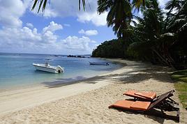
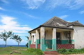
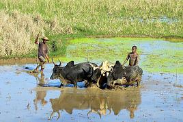
I’m landing in Madagascar with a buddy before the end of April 2026. We’re planning to bike around for about twenty days or so. We don’t have a specific goal other than exploring the country and meeting the locals.
Ideally, we’d prefer a loop route starting from Antananarivo with a good chunk of it along the coast. On the bike side, we’re used to riding 6 to 8 hours a day, depending on the needs, encounters, and mood 😉 Any feedback or tips from trips around this length?
Thanks in advance,
Jérôme
Hi everyone,
After a break of a few years, I’m heading back to Madagascar this October. I’d like to travel from Diego to Maroantsetra via Cap Masoala as much as possible by bike—it’s my favorite way to travel. My questions: for the return trip to Diego once I’m in Maroantsetra, is there a possibility to take a flight, since the road option only starts much further south than Tamatave? Or where can I rent or buy a decent bike between Diego and Cap Masoala? For this bike trip, I’m open to any info—I love traveling rough. Someone might even want to join me on this adventure.
After that, I’d also like info on the northeast part (Mozambique Channel side) of Diego, which I’d like to explore by bike as well.
Thanks, and feel free to share any tips—just skip the paternalistic safety advice. Laurent
After that, I’d also like info on the northeast part (Mozambique Channel side) of Diego, which I’d like to explore by bike as well.
Thanks, and feel free to share any tips—just skip the paternalistic safety advice. Laurent
Hi there,
Last spring, I set off from Villeréal (47) on a road bike and reached the North Cape after 6 weeks of cycling.
I had a particular concept: I’d cycle each stage (averaging 140 km) and then return to the starting point either by carpooling, hitchhiking (not often), bus, or train. I’d meet up with my van (a Trafic) and then drive the same stage to eat and sleep there.
This approach let me choose where I stayed for the night and, most importantly, ride the distance I wanted—my longest stage was 217 km—without carrying any weight, since I can’t imagine doing a fully self-supported bike trip.
I did a first 3-week stretch that took me to the top of Denmark using this method. Then I drove back to Hamburg in my van, left it there, and flew back to Bordeaux.
I spent two weeks at home because my autistic son was staying with me, then my wife and I flew to Hamburg. We picked up the van and drove back to the top of Denmark to catch a ferry to Oslo.
For this second leg, my wife drove the Trafic, and we met up along the stages, which allowed me to focus solely on my ride.
I chose to go through Sweden—it would’ve been much more complicated going up through Norway because of all the tunnels, frequent small ferries to cross the fjords, and a lot more elevation gain.
I had favorable winds most of the time, a few hiccups, but overall everything went smoothly, and I stuck to my route and schedule.
I kept a travel journal on My Atlas—here’s the link: https://www.myatlas.com/danielcramay/du-47-au-cap-nord
Hi there,
Just a few words about the loop I did by bike in Yunnan.
Entry and exit
I entered China through the Sino-Vietnamese border crossing at Lào Cai / Hekou under the 30-day visa exemption currently available to French nationals and others.
The process was simple and quick. A Chinese police officer even helped me complete my electronic pre-registration at a computer kiosk. I wasn’t aware this formality was required—it’s similar to Thailand’s TM6.
No issues with the bike.
I left the country via the Sino-Laotian border crossing at Mohan / Boten.
The atmosphere was a bit chaotic there, but again, no problems with the bike.
The timing
I visited Yunnan in February 2026.
Weather-wise, at higher altitudes (between 1,500 and 2,000 meters), it was around ten degrees at night and in the mornings, and around twenty degrees at the hottest part of the day.
I had two days of rain, so I took the bus to keep moving. Otherwise, clear blue skies.
Culturally, Chinese New Year fell on February 17th (and the 15 days following), right in the middle of my trip. Because of this, my take on the traffic might be off.
Accommodation and food I always found a hotel to stay in for prices ranging from 8 to 15 €. Except in Kunming (the capital), where many hotels were fully booked (Chinese New Year). I ended up at a 100 € hotel with great value for money.
A bowl of noodles costs about 1.5 € on average.
Onboard electronics Since my smartphone doesn’t support eSIMs, I subscribed to a China plan with my carrier. Otherwise, for much cheaper, Alipay offers eSIMs for foreigners that allow access to services usually blocked for Chinese users (WhatsApp, Facebook, etc.).
An internet connection is essential for paying with Alipay or WeChat, as this payment method is widespread.
I only managed to use Alipay.
Either way, always carry cash because sometimes there’s no signal, or the merchant only accepts WeChat.
Also, it’s best to bring a power adapter when you arrive rather than struggling to find one.
Traffic and roads The Chinese aren’t reckless drivers. They follow traffic rules and watch out for cyclists. This is slightly less true in Xishuangbanna (the region bordering Myanmar and Laos).
In urban areas, there are almost always wide bike lanes, separated from other roads, where bikes, electric mini-scooters, and scooters share the space pretty harmoniously.
The roads are in great condition, and traffic is generally manageable—even light—except for one stretch (Eshan -> Yangwu).
Most traffic is absorbed by expressways, China’s equivalent of highways: toll roads that are off-limits to slow vehicles.
You’re never far from these expressways; sometimes you even ride alongside them, which can be noisy at times.
The climbs are usually reasonable, around 5% to 6%. From what I remember, the steepest section was between Menglun and Mengla, with gradients of 8% to 10%, sometimes more.
Riding at these altitudes—though modest—took a bit of getting used to.
The route I didn’t plan anything in advance. My only goal was to reach Kunming. I don’t know why, but just hearing the name of that city, like Yunnan, always felt dreamy to me.
Here’s the breakdown: Hekou -> Man Hao (94 km); Man Hao -> Yuanyang (64 km); Yuanyang -> Jianshui (bus); Jianshui -> Tong Hai (78 km); Tong Hai -> Chenjiang (85 km); Chenjiang -> Kunming (60 km); Kunming -> Kunyang (60 km); Kunyang -> Eshan (67 km); Eshan -> Yangwu (58 km); Yangwu -> Yuanjiang (59 km); Yuanjiang -> Pu'er (bus); Pu'er -> Dadugang (75 km); Dadugang -> Jinghong (80 km); Jinghong -> Menglun (67 km); Menglun -> Mengyuancun (51 km); Mengyuancun -> Mengla (43 km); Mengla -> Boten (67 km).
Otherwise, I’m currently in Thailand and just hoping my return flight with Qatar won’t get canceled.
Oh well... 😉
Just a few words about the loop I did by bike in Yunnan.
Entry and exit
I entered China through the Sino-Vietnamese border crossing at Lào Cai / Hekou under the 30-day visa exemption currently available to French nationals and others.
The process was simple and quick. A Chinese police officer even helped me complete my electronic pre-registration at a computer kiosk. I wasn’t aware this formality was required—it’s similar to Thailand’s TM6.
No issues with the bike.
I left the country via the Sino-Laotian border crossing at Mohan / Boten.
The atmosphere was a bit chaotic there, but again, no problems with the bike.
The timing
I visited Yunnan in February 2026.
Weather-wise, at higher altitudes (between 1,500 and 2,000 meters), it was around ten degrees at night and in the mornings, and around twenty degrees at the hottest part of the day.
I had two days of rain, so I took the bus to keep moving. Otherwise, clear blue skies.
Culturally, Chinese New Year fell on February 17th (and the 15 days following), right in the middle of my trip. Because of this, my take on the traffic might be off.
Accommodation and food I always found a hotel to stay in for prices ranging from 8 to 15 €. Except in Kunming (the capital), where many hotels were fully booked (Chinese New Year). I ended up at a 100 € hotel with great value for money.
A bowl of noodles costs about 1.5 € on average.
Onboard electronics Since my smartphone doesn’t support eSIMs, I subscribed to a China plan with my carrier. Otherwise, for much cheaper, Alipay offers eSIMs for foreigners that allow access to services usually blocked for Chinese users (WhatsApp, Facebook, etc.).
An internet connection is essential for paying with Alipay or WeChat, as this payment method is widespread.
I only managed to use Alipay.
Either way, always carry cash because sometimes there’s no signal, or the merchant only accepts WeChat.
Also, it’s best to bring a power adapter when you arrive rather than struggling to find one.
Traffic and roads The Chinese aren’t reckless drivers. They follow traffic rules and watch out for cyclists. This is slightly less true in Xishuangbanna (the region bordering Myanmar and Laos).
In urban areas, there are almost always wide bike lanes, separated from other roads, where bikes, electric mini-scooters, and scooters share the space pretty harmoniously.
The roads are in great condition, and traffic is generally manageable—even light—except for one stretch (Eshan -> Yangwu).
Most traffic is absorbed by expressways, China’s equivalent of highways: toll roads that are off-limits to slow vehicles.
You’re never far from these expressways; sometimes you even ride alongside them, which can be noisy at times.
The climbs are usually reasonable, around 5% to 6%. From what I remember, the steepest section was between Menglun and Mengla, with gradients of 8% to 10%, sometimes more.
Riding at these altitudes—though modest—took a bit of getting used to.
The route I didn’t plan anything in advance. My only goal was to reach Kunming. I don’t know why, but just hearing the name of that city, like Yunnan, always felt dreamy to me.
Here’s the breakdown: Hekou -> Man Hao (94 km); Man Hao -> Yuanyang (64 km); Yuanyang -> Jianshui (bus); Jianshui -> Tong Hai (78 km); Tong Hai -> Chenjiang (85 km); Chenjiang -> Kunming (60 km); Kunming -> Kunyang (60 km); Kunyang -> Eshan (67 km); Eshan -> Yangwu (58 km); Yangwu -> Yuanjiang (59 km); Yuanjiang -> Pu'er (bus); Pu'er -> Dadugang (75 km); Dadugang -> Jinghong (80 km); Jinghong -> Menglun (67 km); Menglun -> Mengyuancun (51 km); Mengyuancun -> Mengla (43 km); Mengla -> Boten (67 km).
Otherwise, I’m currently in Thailand and just hoping my return flight with Qatar won’t get canceled.
Oh well... 😉
Hi there,
We’re a family of bike-travelers. Our long journey came to a halt in March 2020 in Ho Chi Minh City due to Covid. We’d been on the road for 8 months—2 in Thailand, 1 in Cambodia, and 1 in Vietnam (from the Mekong Delta up to Ho Chi Minh, where we got stopped). We’re heading back to Vietnam in July-August for 5 weeks to finish what we couldn’t in 2020 (introducing my kids to the country of my roots). We’d originally planned to backpack, figuring it’d be tough to cover the country by bike in such a short time... But the urge to pedal is strong for both parents and kids alike.
We’re thinking of keeping 10 days to explore the North by backpack (since the elevation changes are steep) and saving 3 solid weeks for biking—but we’re not sure where (ideally with minimal elevation gain). We’d love to return to Tam Coc (we visited in 2009 without the kids, thanks to Larsay’s great tips—still so grateful for all the valuable advice!). Logistically, we shipped our bikes 5 years ago, but that seems less doable now. We’re considering either renting (though 5 bikes for 3 weeks would get pricey fast) or buying locally to resell or donate afterward.
Is biking in August unrealistic? Thanks in advance for your insights! !
We’re a family of bike-travelers. Our long journey came to a halt in March 2020 in Ho Chi Minh City due to Covid. We’d been on the road for 8 months—2 in Thailand, 1 in Cambodia, and 1 in Vietnam (from the Mekong Delta up to Ho Chi Minh, where we got stopped). We’re heading back to Vietnam in July-August for 5 weeks to finish what we couldn’t in 2020 (introducing my kids to the country of my roots). We’d originally planned to backpack, figuring it’d be tough to cover the country by bike in such a short time... But the urge to pedal is strong for both parents and kids alike.
We’re thinking of keeping 10 days to explore the North by backpack (since the elevation changes are steep) and saving 3 solid weeks for biking—but we’re not sure where (ideally with minimal elevation gain). We’d love to return to Tam Coc (we visited in 2009 without the kids, thanks to Larsay’s great tips—still so grateful for all the valuable advice!). Logistically, we shipped our bikes 5 years ago, but that seems less doable now. We’re considering either renting (though 5 bikes for 3 weeks would get pricey fast) or buying locally to resell or donate afterward.
Is biking in August unrealistic? Thanks in advance for your insights! !
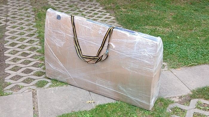
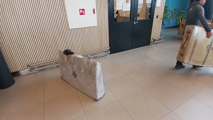
After testing it for three years across various modes of transport, I’m sharing this video of a bike packing case. It’s made from recycled cardboard and shrink-wrapped, with adjustable thickness and added bubble wrap depending on the level of protection you want.
Installing spacers at the fork and chainstays makes the packaging compact. With the fifteen-odd euros for shrink-wrapping at the airport, this case travels really well.
https://youtu.be/_GDJi-GqmkM
- Low bulk (1.10m x 0.70m x 0.25m for a large frame), it fits vertically in train luggage compartments and the total dimensions (x+y+z) don’t exceed 2.40m.
- Two carrying solutions for public transport and easy handling by airport staff (no more tears in the cardboard from openings).
- Discreet packaging when dealing with bus drivers and train conductors, as it looks like an ordinary parcel.
- No need to return to the starting point to retrieve the case from your outbound trip, which you’d otherwise have to store somewhere, or deal with a bulky cover to pack in your panniers.
- You can still check tire pressure through the plastic film without damaging the packaging too much.
Drawbacks: Around 3 hours for this lengthy and meticulous process—removing the wheels, pedals, handlebars, and derailleur without misaligning them, then securing all components to the frame.
If you get a chance to test it, send me your feedback for future improvements.
hi there
After covering thousands of kilometers over the years with front and rear panniers, I’m now facing a problem: broken spokes on the rear wheel.
Once, twice—imagine the hassle of fixing it when you're in the middle of nowhere in the Cévennes!
So, drastic times call for drastic measures! I switched to a reinforced wheel and, following my bike mechanic’s advice, fitted a tire that’s a "tad" wider than the front one.
We set off on our summer adventure feeling confident, and guess what—"BAM"—a broken spoke after just 200 km. Seriously?! Not even that heavily loaded—just around 30 kg, plus my 80 kg. Even with the sturdier wheel, I still ended up with a broken spoke after 300 km! Back to the bike mechanic, and the only explanation: "It’s your pedaling style..." Not convinced at all! So here’s the idea: a Bob trailer! I’m done with this sword of Damocles hanging over my head—it’s a real buzzkill. Has anyone here tried a Bob trailer? Could you share your experiences—pros, cons, etc.? Thanks!!!
We set off on our summer adventure feeling confident, and guess what—"BAM"—a broken spoke after just 200 km. Seriously?! Not even that heavily loaded—just around 30 kg, plus my 80 kg. Even with the sturdier wheel, I still ended up with a broken spoke after 300 km! Back to the bike mechanic, and the only explanation: "It’s your pedaling style..." Not convinced at all! So here’s the idea: a Bob trailer! I’m done with this sword of Damocles hanging over my head—it’s a real buzzkill. Has anyone here tried a Bob trailer? Could you share your experiences—pros, cons, etc.? Thanks!!!
Hi there,
We're thinking of cycling from Lisbon to Vila Real de Santo António in March.
Staying at campsites along the way.
I have two logistics questions:
1) Where to leave the van in Lisbon? Would it be okay to leave it a bit outside Lisbon if needed?
2) Can we take the train back from Vila Real de Santo António to Lisbon with our bikes?
Thanks for any insights!
Momo
Hi everyone,
We’re organizing a week-long bike trip for a group of scouts.
I’ve already mapped out a route using Géovélo (travel option).
The teens will take the train to Nemours (or a bit beyond) and then follow the Loire à Vélo route for a good stretch (until Nevers, which they’ll bypass to the west).
After Nevers, things get a bit trickier.
I also wanted to avoid Moulins, so I planned for them to follow the Allier’s west bank and cross near Châtel-de-Neuvre.
I’m having some doubts about the route and really want to steer clear of busy main roads as much as possible.
I’d love to hear your thoughts on the route I’ve chosen, plus any tips you might have.
I saw there’s the V70 veloroute, but I decided against it after hearing it has some *very* road-heavy sections.
Hi fellow bike-packers,
so I’m heading out solo by bike this spring, like I do every year—around 1,500 to 2,000 km in total.
This time I want to explore the south of France.
I’ll start by meeting up with a buddy in Ariège, and after that the road’s wide open toward the east, aiming for Drôme.
If anyone has route ideas—especially quiet backroads, places I can wild-camp pretty much anywhere, and climbs that aren’t too steep—I’m all ears!
Thanks, and see you around here or on the road.
Take care.
Hi there.
I'd like to change the chainring on my Riverside 5 with trigger shifters.
I’m attaching a photo for advice. I’m lacking power and want a larger chainring for road use because I’m spinning out on the highest gear even though I still have power to give on flat terrain.
At Decathlon, they were supposed to get back to me after checking it out in the workshop but never did. It was outside their standards, and the salesperson clearly forgot about me...
What are your recommendations and suitable products for purchase, please?
Thanks.
Best regards,
Hello young cycling enthusiasts,
I’m starting a thread about the bike route known as venaissia.
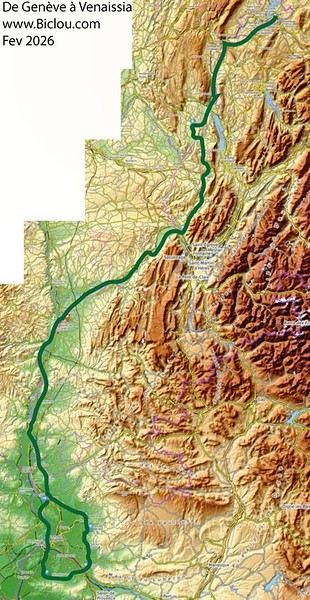
Claudio took advantage of this February 2026’s mild weather to check out what it looks like.
Here we go—story and photos coming soon: http://cbandiera.free.fr/recits/2026-venaissia/
The plan was to go from Faverges to Cavaillon and explore the Via Venaissia a bit. A crazy idea? Maybe, but don’t forget that the month of February—"februare" in Latin—means "to purify," so it’s the Month of the Lupercalia, a Roman festival that was a purification rite. So, to purify himself after the feasts of the Saturnalia, Claudio set off (from an oak tree, no less) to pedal south.
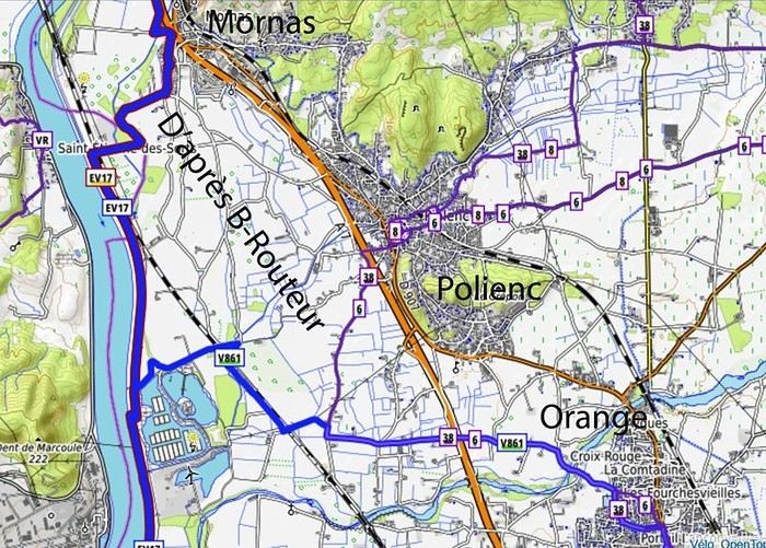
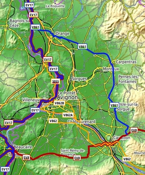
He returned a little soaked but alive: The stages were as follows: (to be continued)
 overall impression:
good signage, but Claudio still managed to get lost in cities like Orange and Carpentras...
Cavaillon... got lost several times, but thanks to the map and GPS, he got back on track...
Nice route, sometimes a bit boring, quiet, deserted (normal given the weather), threatening skies, but he escaped the rain.
overall impression:
good signage, but Claudio still managed to get lost in cities like Orange and Carpentras...
Cavaillon... got lost several times, but thanks to the map and GPS, he got back on track...
Nice route, sometimes a bit boring, quiet, deserted (normal given the weather), threatening skies, but he escaped the rain.
Claudio took advantage of this February 2026’s mild weather to check out what it looks like.
Here we go—story and photos coming soon: http://cbandiera.free.fr/recits/2026-venaissia/
The plan was to go from Faverges to Cavaillon and explore the Via Venaissia a bit. A crazy idea? Maybe, but don’t forget that the month of February—"februare" in Latin—means "to purify," so it’s the Month of the Lupercalia, a Roman festival that was a purification rite. So, to purify himself after the feasts of the Saturnalia, Claudio set off (from an oak tree, no less) to pedal south.
He returned a little soaked but alive: The stages were as follows: (to be continued)
overall impression:
good signage, but Claudio still managed to get lost in cities like Orange and Carpentras...
Cavaillon... got lost several times, but thanks to the map and GPS, he got back on track...
Nice route, sometimes a bit boring, quiet, deserted (normal given the weather), threatening skies, but he escaped the rain.Hi there,
I’m planning the route to cycle from Lille to Nordkapp with my partner.
Duration: 3 months, from May 1st to July 31st, 2026.
In the attached details below, I need to add some "non-riding" days (rest days, basically).
So I’m looking to "shorten" the trip by taking ferries or trains for some stretches. Which areas could I skip?
Thanks in advance for your great tips.
Have a good evening.
https://www.komoot.com/fr-fr/collection/4023980/-lille-cap-nord-1er-mai-au-31-juillet-2026?ref=collection
Good evening,
I’m planning a solo bike road trip along the EuroVelo 6, starting from Orléans all the way to Budapest, beginning May 1st, 2026!
Question: Have any of you used the Warmshowers site, and if so, I’d love to hear your thoughts on using this app—whether responses to hosting requests are generally satisfying, especially for the different countries I’ll be crossing!
Thanks in advance for your tips!
Philippe
Hey fellow cyclists,
Cyclists on trails, paths, or greenways—why do so few (if any) of you use your bells to warn walkers, runners, and other pedestrians when they’re moving in the same direction as you?
I exercise every day (brisk walking) among you in France and abroad, and it’s something I’ve noticed—often with a few scares (and I’m guessing some accidents between cyclists or with pedestrians).
Personally, I always stick to the rules, walking on the left (facing traffic) so I can see you coming, but not everyone does that—neither pedestrians nor cyclists, and let’s be honest, it’s a bit of a free-for-all. 🤪
Your bikes make little to no noise, so why take risks and put others at risk too?
A quick, light *ding-ding* would be enough to warn people—what do you think? 😅
Hi everyone,
I’m trying to get familiar with a route on Locus Map. The issue is that Locus Map’s geolocation isn’t accurate on my PC.
In the link, the red cross shows where I live, and the blue cross shows where Locus Map geolocated me. There’s a difference of about 1.5 km.
My question is: will there always be this kind of error every time I ask Locus Map to geolocate me?
I’m trying to get familiar with a route on Locus Map. The issue is that Locus Map’s geolocation isn’t accurate on my PC.
In the link, the red cross shows where I live, and the blue cross shows where Locus Map geolocated me. There’s a difference of about 1.5 km.
My question is: will there always be this kind of error every time I ask Locus Map to geolocate me?
What’s the maximum weight of gear I can carry in my panniers:
- For a woman on an e-bike
- And for a man on a muscle-powered bike
Thanks
Hi everyone,
I’m heading to Chile this coming November and I’d love to spend a few days cycling from Santiago (Chile) to Mendoza (Argentina).
Has anyone done this route before? If so, do you have any tips (stages, gear, accommodation spots, etc.)?
Also, to avoid carrying too much stuff, I’d like to rent a bike in Santiago. Any recommendations for a good rental shop?
Thanks so much in advance for your help :)
Clément
I’m heading to Chile this coming November and I’d love to spend a few days cycling from Santiago (Chile) to Mendoza (Argentina).
Has anyone done this route before? If so, do you have any tips (stages, gear, accommodation spots, etc.)?
Also, to avoid carrying too much stuff, I’d like to rent a bike in Santiago. Any recommendations for a good rental shop?
Thanks so much in advance for your help :)
Clément
Hello fellow cycling friends,
I’m heading out very soon for a few weeks in France and elsewhere on my trusty two-wheeled steel steed, with a total of me + luggage = around 120 kg gross weight, and I’ve never really tackled mountain passes before—something I’ll definitely be facing this time...
Currently, I’m running 700c wheels and a Deore XT 10-speed drivetrain (long-cage derailleur) with a 26/36/48 chainring setup and an 11-36 cassette. I’m considering two options (and possible modifications) to get a lower gear ratio (currently 0.72) and spin more easily on steep and mountainous climbs...
1 – Install an 11-42 cassette This would give me a gear ratio of 0.61. Would this be feasible with my current rear derailleur, please?
I have several new chains with 116 links—would these work for this cassette, which would have 6 more teeth on the largest cog, or would I need a longer chain?
2 – Swap the 26-tooth small chainring for a 24-tooth one This would give me a gear ratio of 0.66. Would this be feasible, please?
When switching to a 24T, will the gap be accepted by the 36-tooth middle chainring, and will shifting remain as smooth as it is now? Will this setup (24/36/48 + 11-36 cassette) still work well together, in your opinion?
Which of these two options do you think would be more feasible and preferable?
What drivetrain and gearing do you use on your bikes for loaded touring that sometimes involves climbing mountain passes and other steep ascents?
So many questions... Thanks for your answers and advice! Have a great day,
Spady
I’m heading out very soon for a few weeks in France and elsewhere on my trusty two-wheeled steel steed, with a total of me + luggage = around 120 kg gross weight, and I’ve never really tackled mountain passes before—something I’ll definitely be facing this time...
Currently, I’m running 700c wheels and a Deore XT 10-speed drivetrain (long-cage derailleur) with a 26/36/48 chainring setup and an 11-36 cassette. I’m considering two options (and possible modifications) to get a lower gear ratio (currently 0.72) and spin more easily on steep and mountainous climbs...
1 – Install an 11-42 cassette This would give me a gear ratio of 0.61. Would this be feasible with my current rear derailleur, please?
I have several new chains with 116 links—would these work for this cassette, which would have 6 more teeth on the largest cog, or would I need a longer chain?
2 – Swap the 26-tooth small chainring for a 24-tooth one This would give me a gear ratio of 0.66. Would this be feasible, please?
When switching to a 24T, will the gap be accepted by the 36-tooth middle chainring, and will shifting remain as smooth as it is now? Will this setup (24/36/48 + 11-36 cassette) still work well together, in your opinion?
Which of these two options do you think would be more feasible and preferable?
What drivetrain and gearing do you use on your bikes for loaded touring that sometimes involves climbing mountain passes and other steep ascents?
So many questions... Thanks for your answers and advice! Have a great day,
Spady
Hi there,
New to bike touring,
I’d love to start with a section of the Via Rhona to explore and share (route to be decided).
Looking forward to exchanging tips!
Hi everyone,
With summer just around the corner, I’m looking for ideas for organized bike trips in France or Italy. I’m pretty used to traveling independently, but this time I’d like to try something more structured—either in a small group or with minimal logistics (accommodations booked, luggage transport, etc.).
I’m open to different difficulty levels, as long as the setting is pleasant (countryside, seaside, well-known routes, or even a bit more off-the-beaten-path). If you’ve already tried this kind of trip or have good recommendations for agencies or providers, I’d love to hear them!
Thanks in advance for your tips! 🚴♂️☀️
With summer just around the corner, I’m looking for ideas for organized bike trips in France or Italy. I’m pretty used to traveling independently, but this time I’d like to try something more structured—either in a small group or with minimal logistics (accommodations booked, luggage transport, etc.).
I’m open to different difficulty levels, as long as the setting is pleasant (countryside, seaside, well-known routes, or even a bit more off-the-beaten-path). If you’ve already tried this kind of trip or have good recommendations for agencies or providers, I’d love to hear them!
Thanks in advance for your tips! 🚴♂️☀️
We’re planning to cycle along the Baltic coast this summer, from Flensburg all the way to the Polish border—and maybe even a little farther along the Polish coast.
By e-bike and staying in hotels (we’re not exactly spring chickens).
Any tips? Challenges, places to stay, signage?
Other thoughts?
Hi fellow travelers! I’m planning a trip to Japan from March 22 to April 12 and really want to bike the Shimanami Kaido starting from Onomichi, but I don’t cycle regularly. Has anyone here done it and could share their experience or tips? Is the weather in March-April favorable? Should I plan for 2 or 3 days? Electric or regular bike? What’s better—having my luggage forwarded along the route or leaving it in a locker? Any recommendations for accommodations or bike rentals? Thanks in advance for your replies!
Hi,
Like every summer, I’m looking for a (not too distant) destination to cycle with my family for about 3 weeks. I’m drawn to the EuroVelo 1 route in Portugal. Do any of you have information to share? Are there sections that are more or less difficult? Routes that are more or less safe? I’ve heard that Portuguese drivers aren’t very cautious on the road, especially around cyclists.
Thanks for your feedback and experiences!
hi fellow cyclists!
Outside, the weather isn’t great for bike escapes! But that doesn’t stop us from planning ahead. Starting to look at a map or other resources is when the journey begins! So, what are your plans? For us, there’s a trip in the drawer ready for a few months now—heading south (Montpellier) from the Allier department! Another idea has been taking shape: Corrèze, Périgord!!! Looking forward to reading your replies, have a great day! !
Outside, the weather isn’t great for bike escapes! But that doesn’t stop us from planning ahead. Starting to look at a map or other resources is when the journey begins! So, what are your plans? For us, there’s a trip in the drawer ready for a few months now—heading south (Montpellier) from the Allier department! Another idea has been taking shape: Corrèze, Périgord!!! Looking forward to reading your replies, have a great day! !
Coming soon:
https://www.Biclou.com/parcours/durance/
Starting from Faverges: 900 km over 9 days
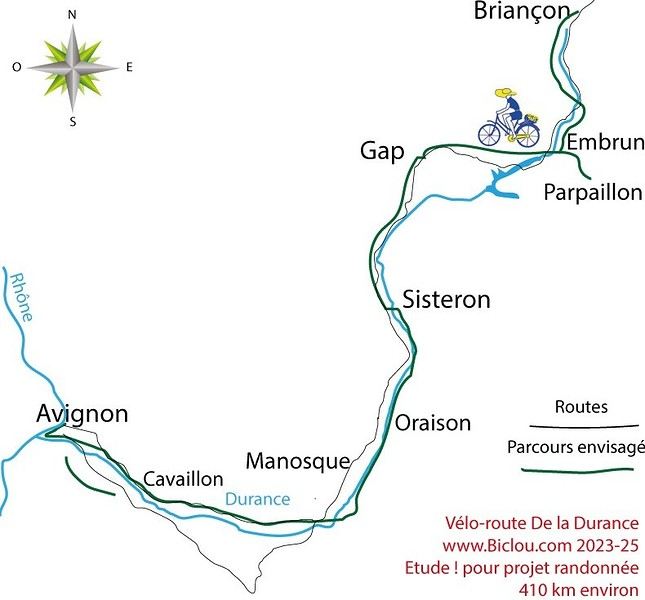
Here’s the detailed Durance route starting from Briançon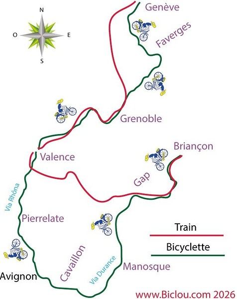
Here’s the detailed Durance route starting from Briançon
Hi there,
Coming from Laos (*), I’m planning to enter Thailand by bike via the Fourth Thai–Lao Friendship Bridge.
Before this bridge was built, I’d already cycled the road from Louang Namtha to Houei Sai and crossed the river by boat to reach Thailand.
At the time, the condition of that road was impeccable, and most importantly, traffic was light.
So I’m wondering if anyone who’s taken it recently can tell me whether traffic has increased since the bridge opened.
Thanks in advance!
(*) I’m currently cycling in China (Yunnan)
Coming from Laos (*), I’m planning to enter Thailand by bike via the Fourth Thai–Lao Friendship Bridge.
Before this bridge was built, I’d already cycled the road from Louang Namtha to Houei Sai and crossed the river by boat to reach Thailand.
At the time, the condition of that road was impeccable, and most importantly, traffic was light.
So I’m wondering if anyone who’s taken it recently can tell me whether traffic has increased since the bridge opened.
Thanks in advance!
(*) I’m currently cycling in China (Yunnan)
I'm planning a 3-day weekend with my wife on this cycle path. The articles about this route are old, so if anyone has traveled it recently and can give me an update on its condition, that'd be great. We're riding 1994 ROCKRIDER 340 mountain bikes but with 1.5-inch tires suited for road touring—will that work, or should I switch back to MTB tires? Thanks for your replies!
A bit disappointed with the forum's revival—there isn’t much activity or shared travel stories anymore.
A bit disappointed with the forum's revival—there isn’t much activity or shared travel stories anymore.
A big thank you to Lazarou for all the info you share in this forum!
I'm passionate about Morocco, which I cycled through back in 2009.
Last year, my wife and I explored the High Atlas by tandem. Completely smitten, we're heading back in April (Anti Atlas) and May (High and Middle Atlas), still on our tandem.
Do you have any info on the track between Amezri and Ali Ait Nito? Are the river crossings in the Tessaout still there? It's not easy to navigate with a loaded tandem... especially if the river level is high due to this year's heavy snowmelt!
Thanks in advance for any tips you might have, and best wishes for health in this new year!
Thanks in advance for any tips you might have, and best wishes for health in this new year!
Hi there,
I’m planning to cycle the Vélodyssée from Hendaye to Saint-Brevin in July 2026. My issue: how do I get to Hendaye with my bike? FlixBus doesn’t take bikes, and SNCF is complicated. Any ideas? Has anyone got a solution to suggest? Thanks in advance! Cheers, Patrig
I’m planning to cycle the Vélodyssée from Hendaye to Saint-Brevin in July 2026. My issue: how do I get to Hendaye with my bike? FlixBus doesn’t take bikes, and SNCF is complicated. Any ideas? Has anyone got a solution to suggest? Thanks in advance! Cheers, Patrig