Hi there,
I’m currently looking for a bike to do my first bike trip across France, with the ultimate goal of cycling through Latin America. I’ve got a lot of questions and I’d love to hear if you have any answers or advice to share.
First off, I’ve been through this before with hiking. I want to get top-quality gear right away. When I started hiking, I ended up buying everything three times—first beginner gear, then intermediate, then expert, etc.
For biking, I’d prefer to skip that process and invest right now in a bike that could ideally handle Latin America.
I’ve set a total max budget of around 5000 € (roughly 4000–4500 € for the bike and the rest for accessories: panniers, helmet, cycling shorts, etc.).
So, I’ve got quite a few questions:
* I’ve read in several places that some people recommend buying the bike directly in Latin America. Since I need a first bike to train in Europe, would it be better to buy an entry-level bike in France (and sell it before the big departure)? Or is it preferable to start right away with my final bike to get used to it? Is buying it there just to save a bit of money?
* For a long-term trip (around six months) in Latin America, is it better to go for a gravel bike or a mountain bike?
* Should I buy a new bike or a refurbished one? Even more so given that I’m planning a long trip—could a refurbished bike end up causing more breakdowns?
If you have any advice on models, technical features to prioritize, or recommended sellers or resellers, I’d love to hear it. I’m a total beginner—I’ve only just started watching videos and reading up on the subject, and all the technical specs are new to me!
Thanks in advance for your help!
I’m planning a journey of about 2500 km starting from San Pedro de Atacama (duration: max. 2 months). This trip, almost entirely on remote trails, promises to be an extraordinary adventure.
Highlights of the trip - Crossing the Florido Desert (during the blooming season: October 15–30) - Hiking ascents of legendary volcanoes: - Ojos del Salado (6879 m) - Llullaillaco (6739 m) - Uturuncu (6008 m, with 5820 m reachable by mountain bike!) - A 300 km stage through the heart of the desert, with no resupply or habitation: the ultimate experience of solitude and self-transcendence.
Practical details - Daily distance: max. 100 km and 1000 m elevation gain per day - Average altitude: 4000 m (between 3500 and 5000 m) - Temperatures: ~15 °C during the day, down to -25 °C at night (in a tent) - Accommodation: ~50% in villages (with locals or small hostels), ~50% camping
Estimated budget - 1400 € for the flight ticket (including bike supplement) - 1000 € for on-the-ground expenses
Required equipment - Fatbike (essential for deep sand) - -25 °C comfort sleeping bag - Single-wheel trailer (indispensable for these tough terrains)
My experience In 2022, I completed a similar 1200 km trip north of San Pedro de Atacama: - Full crossing of the Salar de Uyuni (170 km) - Ascents of the Ollague (5868 m) and Aucanquilcha (6176 m) volcanoes - Two 200 km stages with no resupply or human presence Videos available for a glimpse of the adventure: - Atacama Crossing 2022 - Part 1 - Atacama Crossing 2022 - Part 2
Next steps If this adventure interests you, I suggest: 1. A first phone call to get to know each other 2. A meet-up over a drink or a test ride in the Bardenas Reales (similar terrain, and I live 100 km away)
Don’t hesitate to contact me for more info or to discuss the details!
Highlights of the trip - Crossing the Florido Desert (during the blooming season: October 15–30) - Hiking ascents of legendary volcanoes: - Ojos del Salado (6879 m) - Llullaillaco (6739 m) - Uturuncu (6008 m, with 5820 m reachable by mountain bike!) - A 300 km stage through the heart of the desert, with no resupply or habitation: the ultimate experience of solitude and self-transcendence.
Practical details - Daily distance: max. 100 km and 1000 m elevation gain per day - Average altitude: 4000 m (between 3500 and 5000 m) - Temperatures: ~15 °C during the day, down to -25 °C at night (in a tent) - Accommodation: ~50% in villages (with locals or small hostels), ~50% camping
Estimated budget - 1400 € for the flight ticket (including bike supplement) - 1000 € for on-the-ground expenses
Required equipment - Fatbike (essential for deep sand) - -25 °C comfort sleeping bag - Single-wheel trailer (indispensable for these tough terrains)
My experience In 2022, I completed a similar 1200 km trip north of San Pedro de Atacama: - Full crossing of the Salar de Uyuni (170 km) - Ascents of the Ollague (5868 m) and Aucanquilcha (6176 m) volcanoes - Two 200 km stages with no resupply or human presence Videos available for a glimpse of the adventure: - Atacama Crossing 2022 - Part 1 - Atacama Crossing 2022 - Part 2
Next steps If this adventure interests you, I suggest: 1. A first phone call to get to know each other 2. A meet-up over a drink or a test ride in the Bardenas Reales (similar terrain, and I live 100 km away)
Don’t hesitate to contact me for more info or to discuss the details!
For map lovers, bike routes, cycle touring all over the planet, and long-haul trips...
I had fun compiling in one place ALL the routes my partner and I have biked across the planet since 1996: Quebec far and wide, of course, but also Canada, the USA (crossed completely by bike 3 times), Mexico, and all the way to Ushuaia—basically the entire Americas.
In Europe, the Balkans, Turkey; and more recently (2024: Taiwan, Korea, and 4 months in Japan!) You can check out a global map with all the routes by continent, more detailed maps by country, and others that focus on a region, like the Balkans in Eastern Europe. In short, there’s something for everyone!
I’ve included 3 photos here, but the originals (via the link above) let you zoom in infinitely. Plus, many of my routes are represented by lines with a different color for each day of biking. Hope some of you enjoy browsing through all this as much as I enjoyed compiling it. Until the snow comes, skiing... and spring!
https://www.crazyguyonabike.com/doc/TDM_en_Tandem_Trajets_Maps
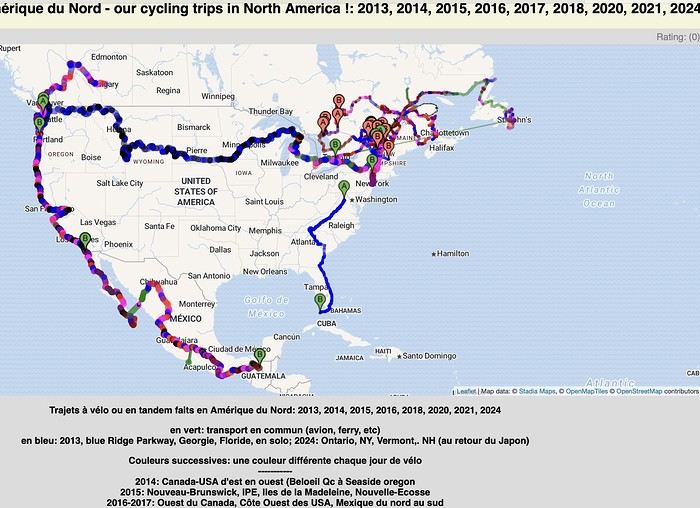
I had fun compiling in one place ALL the routes my partner and I have biked across the planet since 1996: Quebec far and wide, of course, but also Canada, the USA (crossed completely by bike 3 times), Mexico, and all the way to Ushuaia—basically the entire Americas.
In Europe, the Balkans, Turkey; and more recently (2024: Taiwan, Korea, and 4 months in Japan!) You can check out a global map with all the routes by continent, more detailed maps by country, and others that focus on a region, like the Balkans in Eastern Europe. In short, there’s something for everyone!
I’ve included 3 photos here, but the originals (via the link above) let you zoom in infinitely. Plus, many of my routes are represented by lines with a different color for each day of biking. Hope some of you enjoy browsing through all this as much as I enjoyed compiling it. Until the snow comes, skiing... and spring!
https://www.crazyguyonabike.com/doc/TDM_en_Tandem_Trajets_Maps
Hey fellow cyclists,
Cyclists on trails, paths, or greenways—why do so few (if any) of you use your bells to warn walkers, runners, and other pedestrians when they’re moving in the same direction as you?
I exercise every day (brisk walking) among you in France and abroad, and it’s something I’ve noticed—often with a few scares (and I’m guessing some accidents between cyclists or with pedestrians).
Personally, I always stick to the rules, walking on the left (facing traffic) so I can see you coming, but not everyone does that—neither pedestrians nor cyclists, and let’s be honest, it’s a bit of a free-for-all. 🤪
Your bikes make little to no noise, so why take risks and put others at risk too?
A quick, light *ding-ding* would be enough to warn people—what do you think? 😅
Hi there! Every year, we go on a cycling trip abroad with panniers, lasting about two weeks. We stay in step lodgings, guesthouses, and the like. We mostly take small roads and really enjoyed northern Montenegro and Albania last year.
We’d love to hear from anyone who’s cycled in these countries before: tips on finding quiet roads, highlights of the regions we’ll pass through, how welcoming the locals are, and so on. Thanks in advance for any replies or exchanges!
We’d love to hear from anyone who’s cycled in these countries before: tips on finding quiet roads, highlights of the regions we’ll pass through, how welcoming the locals are, and so on. Thanks in advance for any replies or exchanges!
Hi there,
New to bike touring,
I’d love to start with a section of the Via Rhona to explore and share (route to be decided).
Looking forward to exchanging tips!
Hi there,
I’m planning to build a new touring bike. I want to prioritize lightness. That said, I’m tempted by a suspension fork that could offer some comfort on rougher roads. The recent appearance of gravel suspension forks on the market might meet my needs—at least on paper. I’m particularly considering the RockShox Rudy Ultimate XPLR fork. Unlike MTB forks, its travel is short: either 30 mm or 40 mm. It weighs 1400 g, which is 400/500 g more than a steel fork.
Any thoughts or real-world feedback on this?
I’m also wondering about the durability of magnesium (lower leg) for long-distance bike touring. And what’s the impact of skipping the manufacturer-recommended maintenance every 50 and 200 hours? That’s bound to happen on a long trip unless you carry extra gear. More generally, how reliable are these kinds of forks?
Thanks in advance
I’m planning to build a new touring bike. I want to prioritize lightness. That said, I’m tempted by a suspension fork that could offer some comfort on rougher roads. The recent appearance of gravel suspension forks on the market might meet my needs—at least on paper. I’m particularly considering the RockShox Rudy Ultimate XPLR fork. Unlike MTB forks, its travel is short: either 30 mm or 40 mm. It weighs 1400 g, which is 400/500 g more than a steel fork.
Any thoughts or real-world feedback on this?
I’m also wondering about the durability of magnesium (lower leg) for long-distance bike touring. And what’s the impact of skipping the manufacturer-recommended maintenance every 50 and 200 hours? That’s bound to happen on a long trip unless you carry extra gear. More generally, how reliable are these kinds of forks?
Thanks in advance
Hi there,
I’d like to cycle around Guadeloupe during the Christmas holidays. I was wondering if it’s dangerous, if it’s easy to rent a bike, and to find accommodation along the way? Thanks!
We're planning to cycle through Slovenia on touring bikes from July 14th to August 14th. We're used to camping, but I get the feeling there are large areas without campsites. Is wild camping allowed? If not, is it easy to stay with locals?
Could you tell me about the must-see spots in Slovenia? I'm thinking of finishing in Istria, at a seaside campsite to relax and enjoy the sea. Is it pretty quiet there?
Thanks so much, Mireille.
Could you tell me about the must-see spots in Slovenia? I'm thinking of finishing in Istria, at a seaside campsite to relax and enjoy the sea. Is it pretty quiet there?
Thanks so much, Mireille.
Hi there,
Coming from Laos (*), I’m planning to enter Thailand by bike via the Fourth Thai–Lao Friendship Bridge.
Before this bridge was built, I’d already cycled the road from Louang Namtha to Houei Sai and crossed the river by boat to reach Thailand.
At the time, the condition of that road was impeccable, and most importantly, traffic was light.
So I’m wondering if anyone who’s taken it recently can tell me whether traffic has increased since the bridge opened.
Thanks in advance!
(*) I’m currently cycling in China (Yunnan)
Coming from Laos (*), I’m planning to enter Thailand by bike via the Fourth Thai–Lao Friendship Bridge.
Before this bridge was built, I’d already cycled the road from Louang Namtha to Houei Sai and crossed the river by boat to reach Thailand.
At the time, the condition of that road was impeccable, and most importantly, traffic was light.
So I’m wondering if anyone who’s taken it recently can tell me whether traffic has increased since the bridge opened.
Thanks in advance!
(*) I’m currently cycling in China (Yunnan)
I'm planning a 3-day weekend with my wife on this cycle path. The articles about this route are old, so if anyone has traveled it recently and can give me an update on its condition, that'd be great. We're riding 1994 ROCKRIDER 340 mountain bikes but with 1.5-inch tires suited for road touring—will that work, or should I switch back to MTB tires? Thanks for your replies!
A bit disappointed with the forum's revival—there isn’t much activity or shared travel stories anymore.
A bit disappointed with the forum's revival—there isn’t much activity or shared travel stories anymore.
Hi everyone,
I don’t bike much, but I live on the VéloRoute 6, and I dream of adventure. I’m 51 and my old hybrid bike from 20 years ago no longer suits me.
I’d like to get a new bike at a reasonable price, but I don’t know where to look besides Decathlon and Intersport. I’m not after a racing bike—I want something a bit comfortable in terms of riding position (not recumbent) and with a luggage rack. 🙂
All your tips are welcome, with a budget of... let’s say 800 € max.
Looking forward to reading your suggestions!
Richard
I don’t bike much, but I live on the VéloRoute 6, and I dream of adventure. I’m 51 and my old hybrid bike from 20 years ago no longer suits me.
I’d like to get a new bike at a reasonable price, but I don’t know where to look besides Decathlon and Intersport. I’m not after a racing bike—I want something a bit comfortable in terms of riding position (not recumbent) and with a luggage rack. 🙂
All your tips are welcome, with a budget of... let’s say 800 € max.
Looking forward to reading your suggestions!
Richard
Who among you has explored northern Italy along the Mediterranean, in Liguria?
I’m dreaming of cycling there from Nice, crossing through villages like Menton, Ventimiglia, Dolceacqua, Apricale, Monte Ceppo, Triora, Ponte di Nava, Ormea, Garessio, Ceva, Mondovì, and Cuneo.
Beyond that, it’s the route toward Queyras in France via the Col dell’Agnello, on the slopes of Monte Viso.
A few questions for those who know the area: Is it interesting by bike? Is the road surface decent? Is car traffic low, or at least manageable?
We had this plan back in 2009 as part of a Nice-Rome crossing, but we ended up doing it differently. I might get to revisit it this summer (solo this time, not on a tandem like we usually do).
Looking forward to your thoughts and comments!
Beyond that, it’s the route toward Queyras in France via the Col dell’Agnello, on the slopes of Monte Viso.
A few questions for those who know the area: Is it interesting by bike? Is the road surface decent? Is car traffic low, or at least manageable?
We had this plan back in 2009 as part of a Nice-Rome crossing, but we ended up doing it differently. I might get to revisit it this summer (solo this time, not on a tandem like we usually do).
Looking forward to your thoughts and comments!
Hi there,
Has anyone here cycled in the Canary Islands in August? Is it not too hot? Not too crowded on the roads?
Thanks
Hi there,
We’re leaving from Montreal and planning to bike the Petit Train du Nord route.
Any ideas for loops so we don’t have to return the same way?
We’re thinking of a one-week trip.
Thanks in advance for your tips!
Rachel
Hello there, pedal-powered Young Boys!
Claudio (still from Faverges)
dreaming about a cycling getaway in Italy from Faverges (train all the way to Turin)
from Turin down to Venice along the Po River and back via the Padana (Alta Italia da attraversare – Northern Italy to cross)
The tricky part is getting from Chioggia to Venice.
I read it’s possible by hopping on a boat from island to island,
but it sounds a bit stressful.
Has anyone already tackled this route?
Thanks, and cheers to all! http://cbandiera.free.fr/parcours/Padania/
Claudio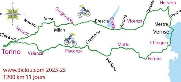
Thanks, and cheers to all! http://cbandiera.free.fr/parcours/Padania/
Claudio
Hi there.
I'd like to change the chainring on my Riverside 5 with trigger shifters.
I’m attaching a photo for advice. I’m lacking power and want a larger chainring for road use because I’m spinning out on the highest gear even though I still have power to give on flat terrain.
At Decathlon, they were supposed to get back to me after checking it out in the workshop but never did. It was outside their standards, and the salesperson clearly forgot about me...
What are your recommendations and suitable products for purchase, please?
Thanks.
Best regards,
Hi there,
I’m planning the route to cycle from Lille to Nordkapp with my partner.
Duration: 3 months, from May 1st to July 31st, 2026.
In the attached details below, I need to add some "non-riding" days (rest days, basically).
So I’m looking to "shorten" the trip by taking ferries or trains for some stretches. Which areas could I skip?
Thanks in advance for your great tips.
Have a good evening.
https://www.komoot.com/fr-fr/collection/4023980/-lille-cap-nord-1er-mai-au-31-juillet-2026?ref=collection
A firsthand account of a 30-day cycling trip (the length of the visa) in southern Vietnam, from Hue to the Mekong Delta. 1,500 kilometers pedaled in December 2022 and January 2023.
Roads and Traffic The roads are generally in very good condition. The secondary road network is limited. Since Vietnam is a densely populated country, needless to say, traffic is often heavy, including on secondary roads. Cyclists, along with pedestrians, are at the very bottom of the road-user hierarchy. In short, when you're on a bike, you never have the right of way. The atmosphere is deafening—Vietnamese people honk all the time. For a Western ear, it's hard to tell the difference between a honk that just signals someone's presence, one that warns of imminent danger, or an angry honk. 😏
Weather Vietnam is a long, narrow country (1,600 km). The weather isn’t the same in the north, center, or south. I cycled through the central part in December. Even though the monsoon peak had passed, I still encountered a lot of rain. Since the monsoon usually lasts until January, it might be better to cycle there starting in February. I was in the Mekong Delta in January. The best season, as it’s the driest month with the least hot temperatures. At this time of year, the prevailing winds come from the northeast. So, it’s better to travel from north to south. That way, you’ll usually have the wind at your back.
Accommodation I always stayed in hotels without ever booking in advance. Typically, I paid between 10 and 20 € for a double room with a private bathroom and AC. To find hotels, I used Google Maps and Maps.me. Wi-Fi is available for free almost everywhere.
The Route Hue → Danang → Hoi An → Nha Trang → Phan Rang → Tan Son → Dalat → Di Linh → Mui Ne → La Gi → Vung Tau → Nha Be → My Tho → Tra Vinh → Can Tho → Cao Lanh → Tranh Hoa → Trang Bang I took the train from Danang to Nha Trang. Not all trains accept bikes, so you’ll need to check beforehand. The railway handles bikes—they’re packed by staff and travel in the same train but in a freight car. I paid 14 € for the ticket plus 7 € for the bike (there’s an extra 0.50 € to pay upon arrival).
The Verdict So, is cycling in Vietnam worth it? If you enjoy biking in traffic, then yes. Otherwise... 😎
Roads and Traffic The roads are generally in very good condition. The secondary road network is limited. Since Vietnam is a densely populated country, needless to say, traffic is often heavy, including on secondary roads. Cyclists, along with pedestrians, are at the very bottom of the road-user hierarchy. In short, when you're on a bike, you never have the right of way. The atmosphere is deafening—Vietnamese people honk all the time. For a Western ear, it's hard to tell the difference between a honk that just signals someone's presence, one that warns of imminent danger, or an angry honk. 😏
Weather Vietnam is a long, narrow country (1,600 km). The weather isn’t the same in the north, center, or south. I cycled through the central part in December. Even though the monsoon peak had passed, I still encountered a lot of rain. Since the monsoon usually lasts until January, it might be better to cycle there starting in February. I was in the Mekong Delta in January. The best season, as it’s the driest month with the least hot temperatures. At this time of year, the prevailing winds come from the northeast. So, it’s better to travel from north to south. That way, you’ll usually have the wind at your back.
Accommodation I always stayed in hotels without ever booking in advance. Typically, I paid between 10 and 20 € for a double room with a private bathroom and AC. To find hotels, I used Google Maps and Maps.me. Wi-Fi is available for free almost everywhere.
The Route Hue → Danang → Hoi An → Nha Trang → Phan Rang → Tan Son → Dalat → Di Linh → Mui Ne → La Gi → Vung Tau → Nha Be → My Tho → Tra Vinh → Can Tho → Cao Lanh → Tranh Hoa → Trang Bang I took the train from Danang to Nha Trang. Not all trains accept bikes, so you’ll need to check beforehand. The railway handles bikes—they’re packed by staff and travel in the same train but in a freight car. I paid 14 € for the ticket plus 7 € for the bike (there’s an extra 0.50 € to pay upon arrival).
The Verdict So, is cycling in Vietnam worth it? If you enjoy biking in traffic, then yes. Otherwise... 😎
It’s never too late to live intensely.
I’m Guy, I’ve passed 70, and I’m looking for a female travel companion for an extraordinary adventure aboard OTONOMI—a solar-powered tandem I built with my own hands over two years.
My past is that of an unrepentant traveler: crossing the Atlantic in an ultralight aircraft, swimming across channels, and a high-level sailing record in major transatlantic races... OTONOMI isn’t a retiree’s whim—it’s the final chapter of a life of adventure, perhaps the most beautiful one.
Departure at the end of May. Route: Europe to Baku, crossing the Caspian by ferry, then Turkmenistan, Uzbekistan, Tajikistan, the Pamir, Kyrgyzstan, and return via Kazakhstan. At least 3-4 months.
No need to be athletic—a session of *longe côte* (coastal walking) requires more physical effort than a full day on OTONOMI. You don’t even have to pedal at all.
OTONOMI tows a foldable solar-powered caravan trailer—camping under the stars or staying in small local hotels, depending on your mood. Road expenses are shared simply.
I’m looking for a free-spirited woman, curious, passionate about genuine encounters and wide-open spaces—appearance or insecurities don’t matter. Just that flame still burning inside you.
A real-life test run is planned before departure—so we can meet naturally, without pressure.
📩 guy.otonomi@outlook.fr
Hi there,
Just a few words about the loop I did by bike in Yunnan.
Entry and exit
I entered China through the Sino-Vietnamese border crossing at Lào Cai / Hekou under the 30-day visa exemption currently available to French nationals and others.
The process was simple and quick. A Chinese police officer even helped me complete my electronic pre-registration at a computer kiosk. I wasn’t aware this formality was required—it’s similar to Thailand’s TM6.
No issues with the bike.
I left the country via the Sino-Laotian border crossing at Mohan / Boten.
The atmosphere was a bit chaotic there, but again, no problems with the bike.
The timing
I visited Yunnan in February 2026.
Weather-wise, at higher altitudes (between 1,500 and 2,000 meters), it was around ten degrees at night and in the mornings, and around twenty degrees at the hottest part of the day.
I had two days of rain, so I took the bus to keep moving. Otherwise, clear blue skies.
Culturally, Chinese New Year fell on February 17th (and the 15 days following), right in the middle of my trip. Because of this, my take on the traffic might be off.
Accommodation and food I always found a hotel to stay in for prices ranging from 8 to 15 €. Except in Kunming (the capital), where many hotels were fully booked (Chinese New Year). I ended up at a 100 € hotel with great value for money.
A bowl of noodles costs about 1.5 € on average.
Onboard electronics Since my smartphone doesn’t support eSIMs, I subscribed to a China plan with my carrier. Otherwise, for much cheaper, Alipay offers eSIMs for foreigners that allow access to services usually blocked for Chinese users (WhatsApp, Facebook, etc.).
An internet connection is essential for paying with Alipay or WeChat, as this payment method is widespread.
I only managed to use Alipay.
Either way, always carry cash because sometimes there’s no signal, or the merchant only accepts WeChat.
Also, it’s best to bring a power adapter when you arrive rather than struggling to find one.
Traffic and roads The Chinese aren’t reckless drivers. They follow traffic rules and watch out for cyclists. This is slightly less true in Xishuangbanna (the region bordering Myanmar and Laos).
In urban areas, there are almost always wide bike lanes, separated from other roads, where bikes, electric mini-scooters, and scooters share the space pretty harmoniously.
The roads are in great condition, and traffic is generally manageable—even light—except for one stretch (Eshan -> Yangwu).
Most traffic is absorbed by expressways, China’s equivalent of highways: toll roads that are off-limits to slow vehicles.
You’re never far from these expressways; sometimes you even ride alongside them, which can be noisy at times.
The climbs are usually reasonable, around 5% to 6%. From what I remember, the steepest section was between Menglun and Mengla, with gradients of 8% to 10%, sometimes more.
Riding at these altitudes—though modest—took a bit of getting used to.
The route I didn’t plan anything in advance. My only goal was to reach Kunming. I don’t know why, but just hearing the name of that city, like Yunnan, always felt dreamy to me.
Here’s the breakdown: Hekou -> Man Hao (94 km); Man Hao -> Yuanyang (64 km); Yuanyang -> Jianshui (bus); Jianshui -> Tong Hai (78 km); Tong Hai -> Chenjiang (85 km); Chenjiang -> Kunming (60 km); Kunming -> Kunyang (60 km); Kunyang -> Eshan (67 km); Eshan -> Yangwu (58 km); Yangwu -> Yuanjiang (59 km); Yuanjiang -> Pu'er (bus); Pu'er -> Dadugang (75 km); Dadugang -> Jinghong (80 km); Jinghong -> Menglun (67 km); Menglun -> Mengyuancun (51 km); Mengyuancun -> Mengla (43 km); Mengla -> Boten (67 km).
Otherwise, I’m currently in Thailand and just hoping my return flight with Qatar won’t get canceled.
Oh well... 😉
Just a few words about the loop I did by bike in Yunnan.
Entry and exit
I entered China through the Sino-Vietnamese border crossing at Lào Cai / Hekou under the 30-day visa exemption currently available to French nationals and others.
The process was simple and quick. A Chinese police officer even helped me complete my electronic pre-registration at a computer kiosk. I wasn’t aware this formality was required—it’s similar to Thailand’s TM6.
No issues with the bike.
I left the country via the Sino-Laotian border crossing at Mohan / Boten.
The atmosphere was a bit chaotic there, but again, no problems with the bike.
The timing
I visited Yunnan in February 2026.
Weather-wise, at higher altitudes (between 1,500 and 2,000 meters), it was around ten degrees at night and in the mornings, and around twenty degrees at the hottest part of the day.
I had two days of rain, so I took the bus to keep moving. Otherwise, clear blue skies.
Culturally, Chinese New Year fell on February 17th (and the 15 days following), right in the middle of my trip. Because of this, my take on the traffic might be off.
Accommodation and food I always found a hotel to stay in for prices ranging from 8 to 15 €. Except in Kunming (the capital), where many hotels were fully booked (Chinese New Year). I ended up at a 100 € hotel with great value for money.
A bowl of noodles costs about 1.5 € on average.
Onboard electronics Since my smartphone doesn’t support eSIMs, I subscribed to a China plan with my carrier. Otherwise, for much cheaper, Alipay offers eSIMs for foreigners that allow access to services usually blocked for Chinese users (WhatsApp, Facebook, etc.).
An internet connection is essential for paying with Alipay or WeChat, as this payment method is widespread.
I only managed to use Alipay.
Either way, always carry cash because sometimes there’s no signal, or the merchant only accepts WeChat.
Also, it’s best to bring a power adapter when you arrive rather than struggling to find one.
Traffic and roads The Chinese aren’t reckless drivers. They follow traffic rules and watch out for cyclists. This is slightly less true in Xishuangbanna (the region bordering Myanmar and Laos).
In urban areas, there are almost always wide bike lanes, separated from other roads, where bikes, electric mini-scooters, and scooters share the space pretty harmoniously.
The roads are in great condition, and traffic is generally manageable—even light—except for one stretch (Eshan -> Yangwu).
Most traffic is absorbed by expressways, China’s equivalent of highways: toll roads that are off-limits to slow vehicles.
You’re never far from these expressways; sometimes you even ride alongside them, which can be noisy at times.
The climbs are usually reasonable, around 5% to 6%. From what I remember, the steepest section was between Menglun and Mengla, with gradients of 8% to 10%, sometimes more.
Riding at these altitudes—though modest—took a bit of getting used to.
The route I didn’t plan anything in advance. My only goal was to reach Kunming. I don’t know why, but just hearing the name of that city, like Yunnan, always felt dreamy to me.
Here’s the breakdown: Hekou -> Man Hao (94 km); Man Hao -> Yuanyang (64 km); Yuanyang -> Jianshui (bus); Jianshui -> Tong Hai (78 km); Tong Hai -> Chenjiang (85 km); Chenjiang -> Kunming (60 km); Kunming -> Kunyang (60 km); Kunyang -> Eshan (67 km); Eshan -> Yangwu (58 km); Yangwu -> Yuanjiang (59 km); Yuanjiang -> Pu'er (bus); Pu'er -> Dadugang (75 km); Dadugang -> Jinghong (80 km); Jinghong -> Menglun (67 km); Menglun -> Mengyuancun (51 km); Mengyuancun -> Mengla (43 km); Mengla -> Boten (67 km).
Otherwise, I’m currently in Thailand and just hoping my return flight with Qatar won’t get canceled.
Oh well... 😉
What’s the maximum weight of gear I can carry in my panniers:
- For a woman on an e-bike
- And for a man on a muscle-powered bike
Thanks
Hi there, we’re planning a Munich to Venice bike trip at the end of June 2026. Getting back from Venice to Toulouse by train with 4 bikes isn’t straightforward. What return options have others who’ve done this trip chosen? Any tips or great deals would be much appreciated. Thanks a bunch! !
Hi,
I’ve browsed the forum but can’t find an answer to my question: Which brand offers bikes suitable for bike touring for an 11-year-old / 140 cm tall? The D4 range is really limited... We’re looking at covering about 50/60 km max per day.
Thanks in advance for your suggestions!
I’ve browsed the forum but can’t find an answer to my question: Which brand offers bikes suitable for bike touring for an 11-year-old / 140 cm tall? The D4 range is really limited... We’re looking at covering about 50/60 km max per day.
Thanks in advance for your suggestions!
hey everyone,
I’m landing in Madagascar with a buddy before the end of April 2026. We’re planning to bike around for about twenty days or so. We don’t have a specific goal other than exploring the country and meeting the locals.
Ideally, we’d prefer a loop route starting from Antananarivo with a good chunk of it along the coast. On the bike side, we’re used to riding 6 to 8 hours a day, depending on the needs, encounters, and mood 😉 Any feedback or tips from trips around this length?
Thanks in advance, Jérôme
I’m landing in Madagascar with a buddy before the end of April 2026. We’re planning to bike around for about twenty days or so. We don’t have a specific goal other than exploring the country and meeting the locals.
Ideally, we’d prefer a loop route starting from Antananarivo with a good chunk of it along the coast. On the bike side, we’re used to riding 6 to 8 hours a day, depending on the needs, encounters, and mood 😉 Any feedback or tips from trips around this length?
Thanks in advance, Jérôme
I'm currently exploring how to create a travel itinerary using AI, specifically ChatGPT.
Question: Bike route from Bordeaux to Paris.
Rough response:
A bike route between Bordeaux and Paris is an incredible adventure, typically around 600 to 650 km depending on the chosen path. Here’s an example of an itinerary with key points:Main Option: La Scandibérique (EuroVelo 3) La Scandibérique is the French section of EuroVelo 3, connecting Bordeaux to Paris through stunning landscapes. This route is well-marked and takes you through small roads and greenways.Main Stages
Bordeaux → Libourne (about 40 km)
Follow the Garonne River, cross the vineyards of Entre-deux-Mers, and reach Libourne, a charming wine town. Greenways available.
Libourne → Périgueux (about 100 km)
Cross the Dordogne with stops in villages like Montpon-Ménestérol. Mix of quiet small roads and trails.
Périgueux → Châteauroux (about 160 km, in several stages)
Through the Parc Naturel Régional de la Brenne. This stage is longer but rich in nature and heritage.
Châteauroux → Orléans (about 110 km)
Reach the banks of the Loire to enjoy the famous Loire à Vélo, a beautiful section with châteaux.
Orléans → Paris (about 140 km)
Pass through the Forêt de Fontainebleau before joining the bike paths along the Seine all the way to Paris.
Question: Bike route from Bordeaux to Paris.
Rough response:
A bike route between Bordeaux and Paris is an incredible adventure, typically around 600 to 650 km depending on the chosen path. Here’s an example of an itinerary with key points:Main Option: La Scandibérique (EuroVelo 3) La Scandibérique is the French section of EuroVelo 3, connecting Bordeaux to Paris through stunning landscapes. This route is well-marked and takes you through small roads and greenways.Main Stages
Bordeaux → Libourne (about 40 km)
Follow the Garonne River, cross the vineyards of Entre-deux-Mers, and reach Libourne, a charming wine town. Greenways available.
Libourne → Périgueux (about 100 km)
Cross the Dordogne with stops in villages like Montpon-Ménestérol. Mix of quiet small roads and trails.
Périgueux → Châteauroux (about 160 km, in several stages)
Through the Parc Naturel Régional de la Brenne. This stage is longer but rich in nature and heritage.
Châteauroux → Orléans (about 110 km)
Reach the banks of the Loire to enjoy the famous Loire à Vélo, a beautiful section with châteaux.
Orléans → Paris (about 140 km)
Pass through the Forêt de Fontainebleau before joining the bike paths along the Seine all the way to Paris.
Coming soon:
https://www.Biclou.com/parcours/durance/
Starting from Faverges: 900 km over 9 days
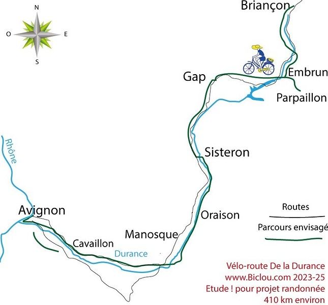
Here’s the detailed Durance route starting from Briançon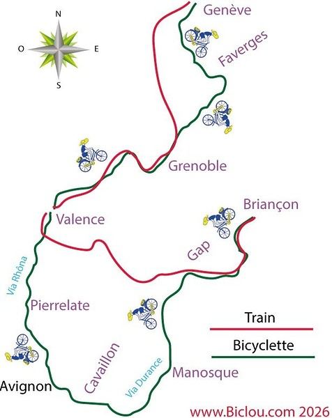
Here’s the detailed Durance route starting from Briançon
Hi,
I’m traveling from Budapest to Belgrade. I had a map up to Budapest.
If you have a marked route (Route 6) starting from Budapest, that’d really help me out since the signage is pretty poor.
Thanks
Hi there,
The full route from Burgos to (just before) Murcia is 1,300 km.
If you’ve done the whole thing, do you think the entire route is worth the trip, or can some sections be skipped?
Thanks.
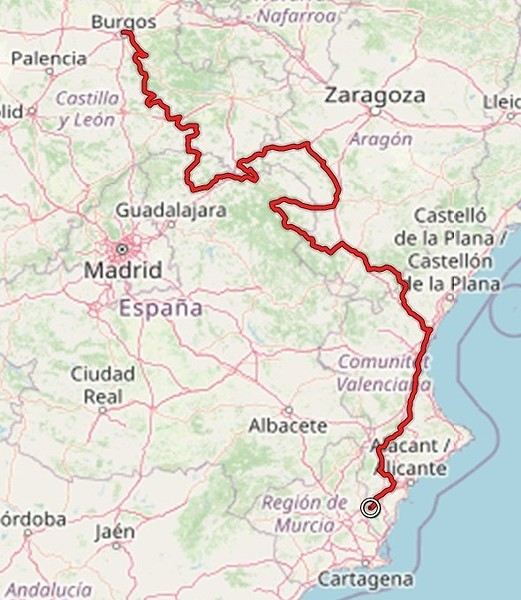
The full route from Burgos to (just before) Murcia is 1,300 km.
If you’ve done the whole thing, do you think the entire route is worth the trip, or can some sections be skipped?
Thanks.
The RandoCamping site is free for users and hosts.
Its goal is to help trekkers find accommodations (usually by the night) all across France and to promote hosts who welcome trekkers satisfactorily.
Check it out here: https://randocamping.touteslatitudes.fr
The site is collaborative and supported by associations like Cyclo-Camping International or AF3V.
It lets you plan a trip or trek (on foot or by bike) by searching for accommodations along a route. The accommodations come from the DataTourisme platform (which aggregates information from Tourist Offices) and from users (trekkers & hosts).
Train lines and passenger stations are also listed. Clicking on a station can show you (if the data is available) how accessible the platforms are with a non-dismantled bike. Bike and hiking routes come from Waymarked Trails (which is based on OpenStreetMap).
You can find more details about the site’s features on this page (version 1.0): https://randovelo.touteslatitudes.fr/randocamping-v1/
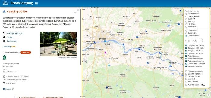
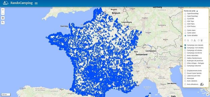
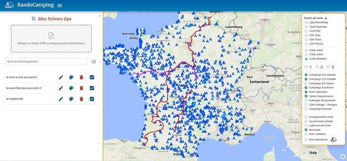
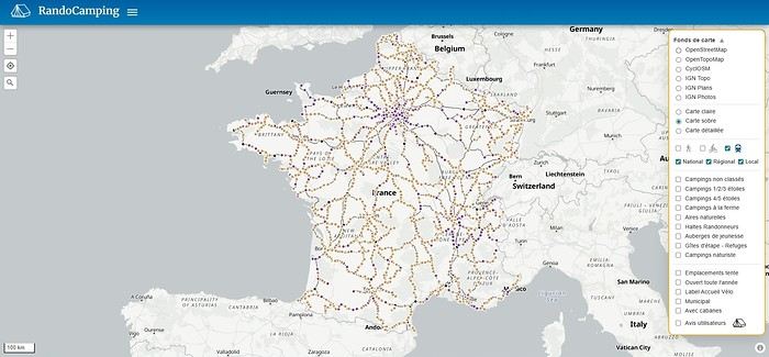
Its goal is to help trekkers find accommodations (usually by the night) all across France and to promote hosts who welcome trekkers satisfactorily.
Check it out here: https://randocamping.touteslatitudes.fr
The site is collaborative and supported by associations like Cyclo-Camping International or AF3V.
It lets you plan a trip or trek (on foot or by bike) by searching for accommodations along a route. The accommodations come from the DataTourisme platform (which aggregates information from Tourist Offices) and from users (trekkers & hosts).
Train lines and passenger stations are also listed. Clicking on a station can show you (if the data is available) how accessible the platforms are with a non-dismantled bike. Bike and hiking routes come from Waymarked Trails (which is based on OpenStreetMap).
You can find more details about the site’s features on this page (version 1.0): https://randovelo.touteslatitudes.fr/randocamping-v1/