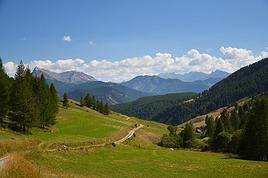
I wanted to share an incredible experience I had recently that really left an impression on me: hiking the Mercantour independently. It’s an absolutely stunning mountain range, with varied landscapes that go from lush forests to rocky ridges, passing through high-altitude lakes with unbelievable colors. I chose a one-week route, sleeping under the stars in a bivouac.
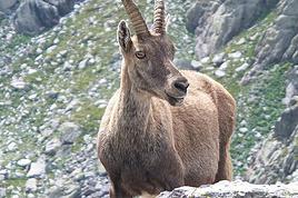
It was a pretty demanding adventure, with significant elevation changes and sometimes unpredictable weather. But every effort was rewarded with breathtaking views. I was lucky enough to spot marmots, chamois, and even ibex in the distance. It’s truly a total immersion in nature!
A little tip for those tempted by the adventure: plan your route and gear carefully. Independence requires good preparation. I particularly appreciated having a good water filtration system and lightweight cookware. And for safety, aside from a map and compass (or GPS), I never leave without my two-way radio. In these remote areas where there’s no mobile signal, it’s a real safety net in case of trouble or just to communicate with other hikers if you’re in a group. It can really make a difference!
If any of you have already hiked in the Mercantour or have questions about my experience, don’t hesitate to ask. I’d love to chat with you about this beautiful range or other hiking destinations.
See you on the trails! 🙂
Hey everyone,
My plan for next November is to head back (yet again) to the Annapurnas to complete a route I’d always promised myself I’d do one day. Here’s the breakdown:
1. Start from Sikles and join the Annapurna Circuit by first going through Kori, then the Namun La (or Namun Bhanjyang). It’s a bit of a forgotten route, and I haven’t found much info on it—no .gpx files or firsthand accounts. Still, I’ve roughly mapped it out using different sources.
2. After that, I plan to head up to Phu to do the direct Phu Pass/Naar Pass traverse to Naar. It’s doable in 2 days, but why not in 1 if the weather’s good and I set off early enough?
3. Finally, I’ll head toward the Mesokanto North Pass (after a short camp at Tilicho North BC) to descend the entire Gandaki Valley down to Nayapul.
I’m obviously looking for any tips or feedback (if you’ve got any), and maybe a travel buddy who’s up for a little off-the-beaten-path adventure. 😄
Hi,
We’re planning to spend 3 nights (4 days) in the Banaue area. We’ve booked 1 night in Banaue, 1 in Batad, and the 3rd back in Banaue. We’d like to get from one village to the other on our own (tricycle + hiking). Does that sound doable? Where can we find a hiking route so we don’t get lost (is Maps.me enough?)? The 2-day trek offered by guides is a bit tough and, above all, too expensive for us (83 €/person). Thanks for your feedback and experiences!
Hello,
We’re planning a 3-week trip to Laos, focusing solely on the north. Our main goal is to do two 4-day treks in two different areas of Northern Laos.
We land in Bangkok on December 12th and will head straight to Chiang Mai before crossing into northern Laos at Huay Xai. Our journey will start there, ending in Vientiane, with a stop in Luang Prabang and the surrounding area. We’ll then take a night train from Udon Thani on December 30th to catch our flight back in Bangkok.
Right now, we’re mainly looking for reliable contacts to organize our two treks. From what we’ve read so far, trekking options exist around Luang Namtha, Phongsali (if it’s not too cold during that period, since we’ll have our 3-year-old daughter with us), or near Muang Ngoi and Nong Khiaw, as we’ve seen there are possibilities in that area too.
If we can organize both treks with the same contact, that would be perfect.
We’d prefer to avoid big agencies with a high-street presence and instead work directly with a local who knows their stuff and can give us good advice. We want to combine stunning landscapes (we love hiking) with cultural encounters in local villages.
We’d love to hear your tips and experiences—maybe some areas are better than others, less crowded, or more challenging (though we’re keeping in mind our 3-year-old, who’s used to hiking but we don’t want to put her in any danger).
That’s the gist of our plans for now! Looking forward to hearing from you, fellow travelers
Hi there,
We’re heading to South Africa in August 2025 and planning a classic loop that I’d love to finish with the Drakensberg (I’m a big hiking fan) before returning to Johannesburg to catch our flight.
I’ve got 3 nights for this part of our trip. But I’m wondering if it’s actually a good idea to hike in the Drakensberg in August, since it’s the Southern Hemisphere winter (I’m from Réunion and we hike year-round there, but I don’t know what the climate’s like in South Africa, especially the Drakensberg).
I’m particularly worried about getting stuck because of snow and missing our flight... ;)
I’ve read so many different things that I’m totally confused!
If it’s okay to hike at this time of year, what would you recommend? I’m torn between Champagne Valley and Royal Natal National Park.
Thanks in advance for your firsthand tips!
Malijp
Hi everyone.
I’m planning a trip to Thailand for November.
We loved the treks we did in Laos, Vietnam, and Myanmar so much that we’d like to repeat the experience in Northern Thailand.
Most travelers who go trekking do it around Chiang Mai. But wouldn’t it be better to do it somewhere else (Chiang Rai?) to get a bit more authenticity?
Any tips would be welcome (agency, guide, route, etc.).
Thanks for your feedback!
Hi there,
I’m looking for organizations that specialize in walking safaris, but not at the price points I’m seeing online.
I’m after a truly immersive experience in the wild, with the option to sleep in very basic tents and help prepare meals...
Ideal duration: 7 to 10 days.
I’d rather avoid the super touristy destinations (Kenya, Tanzania, etc.).
Thanks for any tips you can share! !
Hi everyone, we’re heading to Java in August, specifically to KAWAH IJEN. I’ve seen that there are new requirements like a medical certificate since 2024—is this still the case? Can our 6-year-old daughter do the ascent? Can she go down to see the blue flames at night with gas masks? If not, is it better during the day? Thanks for your feedback!
Hello, We’re heading to Laos in December 2025, and we want to do a multi-day trek—maybe even a week—to really take our time and make stops in villages since we’ll have our 3-year-old daughter with us.
We’re torn between the Luang Namtha region or Phongsaly for our big trek. We’re looking for the least touristy spot possible, we love mountains, so we’d like an area with varied landscapes, including rice paddies, and a chance to really connect with local ethnic groups. We’re after authenticity and only want to stay with locals. Which of the two should we prioritize? Any advice would be welcome to help us decide—it’s tough when you don’t know the area! Maybe there are other spots in the north worth considering for a beautiful week-long trek.
Thanks, fellow travelers
Hi there,
I’d like to hike The Narrows in mid-June. Has anyone done this hike and can share their feedback? I’ll be hiking up to the narrowing, and I saw there’s an outfitter that rents the right gear—I plan to get equipped. Though it depends on a lot of factors, what’s the average water level like at that time of year?
Thanks
Hi there,
I’m planning a 6-day trip from Orléans to Tours.
There are very few detailed maps to figure out the main stages and what you’ll find along the way. Even though I’ve downloaded the Miam Miam Dodo app, it’s pretty tedious (everything is split into small map sections).
I’ve settled on the first leg: Orléans to Meung-sur-Loire, about 18 km. For the next one, I’m hesitating because I’d like to do around 20–25 km, but I see Beaugency is only about 10 km away, and Mer is almost 30 km. So, I’m stuck.
On top of that, I’m torn between taking the GR 3 route or the GR 655 (south).
If any of you know the area or have already done this hike/pilgrimage, I’d love to hear your tips for this section that goes through Blois and ends in Tours.
For the last legs, I’ve planned Blois -> ? Chaumont (no accommodations) -> Amboise -> Tours, knowing the final stage is about 30 km.
Thanks in advance for your help! 😉
Thanks in advance for your help! 😉
Hi everyone! 😊
I’m currently working on a school project about hiking, and I’d really love to hear about your experiences. I’ve put together a short survey (3 minutes max) to better understand hikers’ habits.
👉 Survey link: forms.gle/JyJi8MWKy6aKZyy...
Your participation would help me so much, and all responses will remain anonymous. A huge thank you in advance to anyone who takes the time to fill it out! 🙏 Happy hiking to all! 🦥🌿
P.S.: I’ll delete this post if it doesn’t fit the forum rules.
Hi there,
We’re planning a two-week couple’s trip hopping between the Cape Verde islands at the end of November 2025.
Our arrival and departure airport will be on the island of SAL.
We’ve got some hikes lined up.
Based on your experiences, what recommendations and suggestions do you have?
Thanks in advance for your valuable tips!
Hi everyone,
I’m just at the very beginning of my research, so I’m coming straight to you for some info. I’d like to visit Morocco to discover a bit of the country. I’ve just found out about the Toubkal circuit, which I’d love to do in January/February. I’m open to going independently with a tent, food, etc., and also open to whatever other possibilities this circuit offers that I don’t know about yet... Could you share any random tips or info? I’d also love to hear your opinions? What I like about this circuit is that it’s fairly accessible and seems interesting for many reasons. I’ll leave it to you to share your thoughts—thanks in advance for your help! 🙂 Wishing you all lots of exciting plans for the new year ahead!
Nicolas
Hi there,
This summer, my sister and I would like to do part of the tour of old Chaillol. We’re thinking of leaving our car at Chapelle en Valgaudemar and going hiking for three days with two nights in a mountain refuge. At the end of the third day, do you know if it’s possible to take a bus or coach to get back to Chapelle en Valgaudemar? From Pont du Fossé or Chabottes. If not, would you have another more suitable route to suggest?
Thanks in advance.
hi there,
I’m planning a trip around Cap Corse and the AGRIATES in 2026, from May 8th to 15th (there are still 2 spots left, by the way! Just DM me if you're interested).
I’d love to know which hikes are worth prioritizing in the AGRIATES. We’ll be staying in SALECCIA for two days as our base—what should we focus on from there? A round trip to IGNHU beach? Any other suggestions? For Ostricano, I think it’s too far for a round trip... Thanks for your tips! Have a great day, Anie, Toulouse
Hi there!
I’m heading out in August for a two-day trek in the Vale do Pati. Do I need proper hiking boots, or will trail-running shoes do the job?
Thanks in advance for your feedback!
😊😃
Hello everyone,
We’re planning to spend 15 days in early May in La Gomera, solely for hiking and exploring the island. We like to take our time and not rush to see everything. We’ve booked small hostels or hotels, and our itinerary will be: San Sebastian -> Playa Santiago -> Valle Gran Rey -> Vallehermoso -> back to San Sebastian
We’re hesitating about renting a car—it would certainly give us more flexibility compared to buses, but it also comes with a budget and responsibilities (parking, getting back to the car after a hike, driving fatigue, distances, etc.). Since hiking is our main focus, the ROTHER guidebook shows mostly hikes that are accessible by bus. Is the bus network reliable? Is it restrictive to go without a car, with 2 or 3 nights in each location?
Thanks for your feedback—we can’t decide!
Best, Thomas
Hi there, we're heading to Nepal in a few weeks and planning a relaxed trek from Jomsom to Tatopani along the left bank of the Kali Gandaki. Starting from Kokhetanti, we'd like to do a day loop to Sekong Lake, then head to Naurikot and return (possibly by road). We’ve found—well, *found* might be a strong word—a path to the lake, but we can’t see any route continuing to Naurikot. Can anyone help us out? Thanks so much! !
Hi there, for those who’ve been recently—is it possible to find other solo travelers in March on the island to share transport or room costs? It doesn’t seem easy to travel on a budget.
If you have any recommendations for simple lodgings or places with dorms, I’d love to hear them.
For those who’ve done multi-day treks while moving around: do you need to bring your own sleeping bag? I’d love to hear about itineraries you’ve done without a guide, just with a map and GPS.
Thanks, and have a great day!
I want to do sections of the Collioure-Cadaqués trail. I plan to stay in Collioure first to hike the paths on the French side using the bus. Speaking of which, I’m wondering if it’ll be easy to find a seat on the buses at the end of April, beginning of May.
After that, I’ll head to Figueres to do sections of the trail on the Spanish side. I’m worried the buses might not be too crowded at the end of April.
Here’s what I’m interested in: Llanca - Port de la Selva: Figueres - Llanca by train in the morning and Port de la Selva - Figueres on the way back Port de la Selva - Cadaqués: Figueres - Port de la Selva in the morning and Cadaqués - Figueres on the return trip
I’d also like to go to Cadaqués from Figueres as a day trip. I’m concerned about how busy this route might be at the end of April.
I’m wondering if I need to get tickets in advance and where to buy them.
Hi there.
I’ve hiked the GR trail mentioned in the title from Wissembourg all the way to Menton.
Now I’ve got the section from Wissembourg to Rotterdam left.
But I can’t find any maps for this route—I’m looking for someone who’s done this part of the trail.
Thanks in advance! 😊
Hey everyone!
I’d like to explore the northeast of Madagascar, using bush taxis, boats, and my own two feet.
I already have an ideal itinerary in mind, but I’d love to know if it’s doable at a relaxed pace in one month. The goal, of course, is to avoid being constantly focused on time and days and to travel spontaneously.
I’m aware that the roads are rough and there are a lot of unexpected delays, which isn’t a problem in itself. I just struggle to estimate the *time* it takes to get between stops.
Potential itinerary:
Tana – Sainte Marie Island (4 days) – Maroantsetra (3 days) – Masoala Park (8-day trek?) – Antalaha – Marojejy Park (3 days) – Ambilobe – Nosy Be (5 days) – Tana
The days listed are just rough averages. Cities don’t interest me, and I don’t plan to visit Tana.
I’d really appreciate any info or tips from you all! 😊
Thanks in advance,
Romain
Hi everyone,
I’ve planned a little day trip with my kids (12 and 16 years old) to Venice. The goal is to go for a walk through the city’s streets rather than visiting museums, which would take way too much time. We’d like to pass by the main landmarks, so I’ve put together a small 15 km hike... (thanks to Komoot and visioRando). Could you take a quick look and let me know if I’ve missed anything or made any mistakes?
1. Start at Santa Lucia Train Station 2. Ponte Degli Scalzi 3. Ponte dei Pugni 4. squero de San Trovaso 5 Le rio della Salute 6. Accademia Bridge 7. St. Mark’s Square 8. St. Mark’s Basilica 9. Ponte de la Canonica 10. Ponte de la Pietà 11. Ponte de la Tana 12. The Arsenale 13. Bridge of Sighs 14. Doge’s Palace Then return to the Rialto Bridge via Marzaria dell’Orologio
Also, could you tell me if the Doge’s Palace courtyard is paid entry? Thanks for your help and feedback!
Stéphane.
Hi there,
I'm looking for some nice hikes to do on foot around Fréjus.
Thanks
Hi there! 😊
- About fifteen kilometers from Gallup, where we’re stopping, there’s a small state park: Red Rock Park.
Two hikes are catching my eye:
Pyramid Rock Trail (229 m elevation gain, 5.5 km, 1h45)
Church Rock Trail (78 m elevation gain, 3.5 km, 1 hour)
Has anyone been there? And if so, which one would you recommend?
Thanks for your replies and have a great rest of your afternoon!
Marcalamar :)
Hi,
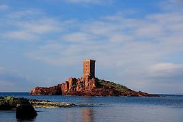
I’ll be arriving in Nice from Quebec on June 20th. I’m planning to rent a car for 7 days to do day hikes in Mercantour Park. Which village would be best to stay in? Saint-Martin-Vésubie? Barcelonnette? Or split my time between both to access different areas of the park and avoid too much driving? Also, are there hikes in lush, flower-filled valleys (like alpine meadows)?
Thanks,
Sylvie
Hello,
I'm planning to travel from Matsumoto to Tsumago to hike to Magome. Is it reasonable to leave early in the morning from Matsumoto by train, stop in Narai for a stroll (knowing we'll have our big backpacks, I hope there's a luggage locker at the station), and then continue to Tsumago to do the hike to Magome?
Or is it better to stop and sleep halfway in Kiso-Fukushima? (I looked for accommodations in Narai but couldn't find any.)
Thanks in advance for your advice.
Hello,
I’d like to know what small gifts I could bring for women, children, and men in the Surma tribes of the western Omo Valley.
Usually, I bring pencils, pens, perfumes, and cigarettes, depending on the country.
What do you recommend?
Philippe Departure on 11/13/24
What do you recommend?
Philippe Departure on 11/13/24
Hi there,
I’m planning to do the Mercantour crossing following the Randoxygène route in mid-July. I’m used to hiking in the mountains, but I sometimes get vertigo, for example on ridges with drops on both sides. I wanted to check if there are any T4 or T3-T4 sections and find out if there are any very exposed passages—and if so, where—so I can plan an alternative route. Can anyone give me some info on this? Thanks!
I’m planning to do the Mercantour crossing following the Randoxygène route in mid-July. I’m used to hiking in the mountains, but I sometimes get vertigo, for example on ridges with drops on both sides. I wanted to check if there are any T4 or T3-T4 sections and find out if there are any very exposed passages—and if so, where—so I can plan an alternative route. Can anyone give me some info on this? Thanks!