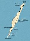
Difficile de trouver sur internet une carte routière de Madagascar détaillée et à jour.
Après plusieurs voyages à Madagascar j'ai décidé d'en réaliser une pour offrir à ceux qui préparent un voyage pour cette destination une carte à peu près fiable.
Vous la trouverez à l'adresse suivante :
http://syal.fr/madagascar/cartemadagascar.html
C'est un site perso non commercial.
Toute suggestion pour l'amélioration de la carte sera la bienvenue.
Bonjour,
excellente initiative. Juste quelques détails, sauf erreur de ma part :
il y a marqué Isohy au lieu de Ihosy.
Vaingandrano au lieu Vangaindrano,
Tolanaro au lieu de Tolagnaro,
Berakera au lieu de Beraketa,
Ambodofotatra au lieu de Ambodifotatra,
Solala au lieu de Soalala,
Maroantsetra, au lieu de Maroensetra,
Enalalava au lieu de Analalava,
Baie d'Atangil au lieu d'Antongil,
Norafenobe au lieu de Morafenobe,
Beau travail utile toutefois,
Le must si quelqu'un a tout fait serait de faire la même carte avec les temps de parcours ! Pourquoi ne pas faire une telle carte collectivement avec tous les forumistes ?
amicalement,
En ce qui concerne les temps de parcours j'y avais vraiment pensé car à Madagascar on ne compte pas en km. Il faut effectivement du monde pour faire ce travail qui pourrait donner une idée de la réalité du voyage. Mais d'une année à l'autre ça évolue. les routes se dégradent très vite même si j'ai pu constater des améliorations sensibles entre 2005 et 2008 sur la N7 entre Tana et Diego ou entre Fianarantsoa et Mananjary... et de rares autres. Souvent c'est du rapiéçage qui dure peu. Et les cyclones n'arrangent rien. Et en plus de l'état des routes il y a les aléas, les crevaisons à répétition, l'état du véhicule, les humeurs du conducteur, les attentes, enfin tout ce qui fait finalement le charme d'un voyage à Madagascar.
Ceci dit je suis prêt à rajouter des éléments temporels si suffisamment de gens peuvent transmettre leur expérience, ça donnera une idée à ceux qui vont à Madagascar pour la première fois. Le plus souvent on sait d'où on part et où on va arriver mais on ne sait ni quand on partira ni quand on arrivera. J'exagère un peu mais il y a un peu de ça. Je n'ai vu l'exactitude qu'avec Gazy Bus Car (assez cher - on le fait une fois dans un voyage) qui ne fait des trajets que sur route en bon état.
Le plus grave c'est le chaos dans lequel se trouve ce pays. L'espoir de voir les choses changer il y a un an est resté sans lendemain, la situation politique est dans une impasse, l'activité déjà au plus bas régresse... et Tana vit dans la saleté et la débrouille. J'imagine l'état des routes et des voitures.
Mais les Malgaches isolés dans leur île ont besoin qu'on ne les oublie pas.
Donc avis aux amateurs, si vous avez des temps de trajet mettez les sur le forum. Merci
Le must si quelqu'un a tout fait serait de faire la même carte avec les temps de parcours ! Pourquoi ne pas faire une telle carte collectivement avec tous les forumistes ?
Nogir
Arf je me cite moi-même, trop fort !
En ce qui concerne les temps de parcours j'y avais vraiment pensé car à Madagascar on ne compte pas en km. Il faut effectivement du monde pour faire ce travail qui pourrait donner une idée de la réalité du voyage. Mais d'une année à l'autre ça évolue.
Capalouest
Si tu te sens de collationner les renseignements de chacun, ça serait utile et sympa.
Chaque apport de temps de parcours d'un forumeur devrait être accompagné de la date, du moyen de transport et des aléas éventuels.
Amicalement,
Nogir
tres belle carte avec de superbes photo mon compagnon part dans 5 jours pour mada j espere de tout mon coeur un jour pouvoir y aller aussi encore bravo🙂
Merci.
Attention, quand on y est allé une fois à Madagascar on n'a plus qu'une envie c'est d'y retourner.
Vous n'irez probablement pas en camion. Ceci dit on en trouve dans les pistes défoncées.
Je vous propose plutôt ça :
géniale cette carte..j'aurais bien aimé l'avoir qd j'ai fait Tana - Majunga et la région autour...
qq'un peut-il me dire si internet marche à Majunga; si oui je cherche les coordonnées de Amine Nouraly, boulanger à mahabibo , son père était à Marovoy...merci
tonytruand
il y a ceux qui voient les choses telles qu'elles sont et qui se demandent pourquoi; moi je les vois telles qu'elles pourraient être et je me dis pourquoi pas ?( 2005 )
Je vais essayer de rassembler des renseignements concernant les temps de trajets. Je te demanderai certainement un peu de contribution dans la mesure où tu es sur place et peut-être en mesure d'obtenir des renseignements.
Bon je verrai tout ça lundi.
Salut
Bonjour,
quand tu "imprimes" en choisissant "adobe PDF", la page est sauvegardée dans un document pdf dont tu as choisi la destination (mes documents par exemple).
Tu peux ensuite ouvrir cette page enregistrée et la consulter, la copier ou la modifier.
Cordialement.
Bonjour,
Tout d'abord félicitations pour le travail effectué.
J'ai juste une petite remarque à faire pour rectification sur le carte. Entre Vatomandry et Mahanoro ce n'est plus une piste mais une route en excellent état.
Dans le même ordre d'idée, la route de Sambava à Antalaha est aussi de très bonne qualité à défaut de photo de la route, que je connais bien pour l'avoir déjà emprunter, je joins ce lien:
; Bonne idée...
Mais juste pour le fun: N'oubliez pas le fait que la saison des pluies fait disparaitre de nombreuses pistes ou au mieux les rendent totalement impraticables même avec un 4x4 au top !
veloma.
JaKe.
On ne va jamais si loin que lorsque l'on ne sait pas ou l'on va.
J'ai fait les modifications concernant les noms des villes erronés.
Je reçois pas mal de modifs à faire. C'est une très bonne chose. Si ça devient une œuvre collective c'est tant mieux. Un forum c'est bien fait aussi pour ça.
J'ai l'intention de mettre en annexe les noms (ou pseudo) des contributeurs sauf s'ils le souhaitent pas.
Enfin j'ai enlevé la protection contre la copie qui finalement ne m'a plus semblé conforme à ma démarche.
J'ai enlevé la protection contre la copie.
Il me reste encore des vieux réflexes de propriété qui n'ont effectivement pas leur place dans un forum de partage.
Amicalement
Bravo pour ce travail ! Intéressant d'avoir ça dans son ordi - dossier Mada.
Pour ma part, avant de partir en septembre 2009, j'ai acheté la carte Michelin de l'Afrique du Sud et sur celle-ci, j'ai découpé la carte de Madagascar qui y figure en bas à droite. Parce que la carte de Mada n'existe pas chez Michelin apparemment. Une fois découpée, j'ai pu plier la carte qui a pris alors très peu de place et la garder sur moi. Vous pouvez peut-être vous en inspirer pour faire la vôtre.
L'idéal effectivement serait d'avoir le temps de trajet en même temps que les km. Moi je calcule le temps français et je multiplie par 2, sauf imprévus... Et les imprévus à Mada, c'est tous les jours. Hi hi !
Bonne journée
une trés bonne initiative pour cette carte et cela dit en passant une petite contribution à l'élaboration de celle-ci
j'opterais pour ces villes pittoresque ...massif...ilots...
- Tsiroanomandidy le premier marché de zébus et Ambohimahasoa pour les volatiles dans l'ile.
- un peu de relief, le plateau de Bemaraha- le Bongolava- et le Tampoketsa
- d'exotisme, les iles Barren au sud-ouest de Maintirano et malheureusement la fameuse Nosy-Lava au large d'Analalava
sans oublier le tropique du Capricorne
a+ pour d'autres apports, et bonne continuation
veloma
l'important n'est pas de convaincre, mais de donner à réfléchir
Bonjour,
Tres bonne initiative, tres beau travail. Bref c est excellent.
Petites remarques :
- je ne connais pas cette piste qui part de Fianar pour Malaimbandy (et pas Malaimbrandy d apres mes archives). N est ce pas plutot la piste qui quitte la RN7 a quelques kilometres d'Ambositra pour rejoindre Malaimbandy ? A ce moment la, c est tt de meme assez loin de Fianar
- a l ouest de Fianar, par contre, il y effectivement une piste qui fait : Fianar-Nasandratrony (en partie goudronnée), Isorana, Ikalamavony, Fitampito. Mais a ce que je sache elle s arrete a peu pres a Fitampito (environ 130 kms)
- comme c est une carte routiere, je ne pense pas, sauf travaux recents, qu on puisse aller d Ambalavao a la cote par une piste en 4x4. Faisable a pied par contre. 1ere piste : Ambalavao-Ambohimahamasina point le plus a l est par auto a ce que je sache. Sinon 2 pistes principales qui vont vers l Andringitra mais sans traverser le corridor.
- la piste qui part de la N12 (grosso modo Fianar-Manakara) et qui va vers la voie ferrée FCE croise la ligne de train a Tolongoina. Ca pourrait etre noté ainsi les voyageurs savent qu ils peuvent s arreter a cette gare et retrouver Ifanadiana puis Ranomafana par 4x4 si ils ne veulent pas aller jusque Manakara en train.
Encore une fois, c est du top, quelques petites remarques avec beaucoup d humilité vis a vis du travail réalisé.
A plus
Merci d'avoir regardé en détail.
Il n'y a effectivement pas de piste entre Malaimbandy et Fianar. En revanche il y en a une entre Malaimbandy et Ambositra. En plus je le savais. En 2005 j'ai fait Morondava Ambositra et je suis passé par Antsirabe car les taxis brousse ne font pas le trajet direct Malaimbandy-Ambositra vu l'état de la piste. Je corrige rapidement.
D'autre part tu m'indiques la piste qui va de Tolongoina à Ifandiana. Peux tu m'indiquer son état ?
Amicalement
Bonjour
OK pour la piste Malaimbandy/environs d Ambositra, état toutefois à confirmer car on me disait que ca passait en moto mais pas en 4x4
Pour la piste Ifanadiana/Tolongoina (qui est indiquée sur votre carte), les derniers échos que j ai eu en 2008 indiquait que cela passait en saison seche mais en saison des pluies tres difficile a pas possible. Je ne sais pas comment c est depuis.
Le must si quelqu'un a tout fait serait de faire la même carte avec les temps de parcours.
alors là, bon courage.
Il faudrait une carte pour les trajets en taxi-brousse, une pour les trajets en 4*4, une pour les trajets en voiture classique, une pour les trajets en charette à Zébu !!! Et à cela il faut tout multiplier par 2 : saison sèche et saison des pluies !!!!
bonjour
la piste de Fianar à Malaimbandy existe et praticable en saison sèche de préférence en moto
- prendre Talata-Ampano à quelques kilomètres au sud de Fianarantsoa
de là- Isandratrony-Ambovony-Tsitondroina et arrivée à Lanjiva
à gauche la direction de Malaimbandy
à droite celle qui rejoint Amborompotsy -Ambatofinandrahana-ivato- Alarobia_Ambovombe pour ensuite rejoindre la RN7 à mi chemin d'Ambositra et la capitale du Bétsileo
l'important n'est pas de convaincre, mais de donner à réfléchir
Bonjour
Merci de cette info, je ne connaissais pas cette piste. Qui doit toutefois certainement pas etre bien grosse. Mais que je me ferai un plaisir de tester si j en ai l occase.
Je n arrive pas a voir comment elle va jusque Malaimbandy sans croiser la piste Fianar-Ikalamavony-Fitampito. Et si elle la croise, je ne vois pas ou.
A Talata-Ampano, ne pas rater au bord de la RN7 le meilleur poulet grillé/braisé/doré de Mada.
A+
sans aller à Fitampito où la piste s'arrete aux trois confluents
c'est à Ikalamavony qu'il faut prendre Tsitondroina (70km), de là changement de la piste en sentier convenable jusqu'à Malaimbandy, au moins 6 à 8h de trajet harassant
et pour le poulet braisé de preference je le marierais avec un vin nouveau de la région😏 roti en hiver avec un ambodivoary (modéré le comsom) 😇😇
l'important n'est pas de convaincre, mais de donner à réfléchir
Bonsoir ;
Internet marche a Majunga meme si les temps de connexion sont quelques fois assez longs.
Pour la boulangerie il y en a une a Mahabibo aujourd'hui tenue par un vahaza.Il y en a peut etre une autre dans ce quartier . Si tu peux me donner des precisions par exemple nom de l'enseigne j'essaierai de me renseigner.
salut...amine était le goal de mon équipe de foot qd j'étais à la fac d'Orsay (91 ) son pére était boulanger et sa mère tenait la pharmacie à Marovoy qd je suis passé les voir en 1990 je crois...merci de ta réponse...
tonytruand
il y a ceux qui voient les choses telles qu'elles sont et qui se demandent pourquoi; moi je les vois telles qu'elles pourraient être et je me dis pourquoi pas ?( 2005 )
Bonsoir;
Merçi pour ta carte claire.
J'apporte une precision concernant la portion de route Manpikony Port Berger.
De la sortie de Manpikony il y a environ 40 km difficiles en saison seche et quasiment impraticables a la saison des pluies (route defoncée par des camions surchargés) .
Piste Antsohihy / Analava impraticable a la saison des pluies .
Cordialement
Lakana
Bonsoir;
Merçi pour ta carte claire.
J'apporte une precision concernant la portion de route Manpikony Port Berger.
De la sortie de Manpikony il y a environ 40 km difficiles en saison seche et quasiment impraticables a la saison des pluies (route defoncée par des camions surchargés) .
Piste Antsohihy / Analava impraticable a la saison des pluies .
Cordialement
Lakana
Bonsoir😉
Tu as raison de préciser que pas mal de pistes sont impraticables durant la saison des pluies et pas uniquement sur la façade est de Mada.
Amicalement😎
Tant que la couleur de la peau sera plus importante que la couleur des yeux, nous ne connaitrons pas la paix.
Merci pour tes remarques sur la carte.
En ce qui concerne la portion de route Manpikony à Port Bergé, j'avais eu l'information quand je suis allé à Diego en 2008, par des gens qui avaient fait la route Tana-Diego, que la N6 avait été entièrement refaite en 2007.
L'image de Google Earth est trop ancienne, elle ne peut pas me renseigner.
Peux tu me dire de quand date ton information ?
Ou bien quelqu'un peut-il la confirmer ?
Amicalement
Bonjour;
J'ai pris la route Mampikony / Port Bergé en Aout 2009 .A cette epoque il y avait des travaux de refection de ponts et je pensais que la refection de la chaussée allait suivre.
La portion degradée commençait un peu après Mampikony on pouvait rouler assez lentement.
Un ami a pris cette route en Janvier 2010 avec un 4x4 et il me confirme que c'est actuellement impraticable a cause de la pluie. .Nombreux camions et taxi brousse bloqués.
Si quelqu'un a d'autres precisions ?
Cordialement
Lakana
je dois me rendre à Madagascar en Avril, et je peux te dire que cette carte m'éclaire vraiment sur les distances et surtout sur la qualité du reseau routier.
mille merci pour cette implication qui en aidera plus d'un
si je peux me permettre une suggestion, le kilometrage en blanc n'est pas très visible et lisible.
mais à part cela encore bravo pour ton altruisme
Je suis ravi que cette carte rende service.
J'avais déjà noté que le kilométrage en blanc n'était pas top. J'ai commencé une nouvelle présentation plus claire qui devrait être en ligne rapidement.
Je n'ai pas oublié ton message. Il faut que je vois comment insérer des infos particulières ou locales sans surcharger la carte.
Pour le moment ma priorité c'est d'avoir une fiabilité sur les routes et les pistes.
Je mets de côté le reste que j'utiliserai quand j'aurai résolu le problème technique d'insertion sans surcharge. A priori je pense à mettre des calques transparents avec l'info qu'on pourra ouvrir à la demande ou l'ouverture sur une autre page. A voir.
Je cherche un guide complet et une carte détaillée sur Madagascar, afin de préparer mon prochain voyage. J'envisage un circuit sur 3 semaines/1 mois, en…
En faisant des recherches pour notre prochain périple sur la cote Est de Tamatave à????? peut être cap de masoala (mananara au moins de toute façon)..à pied…
Je suis à la recherche sur internet d'un plan ou d'une carte détaillée de la région au dessus de Fort Dauphin car nous nous lancons (à pied) à un trek de FD en…
Je cherche désespéremment des cartes à l'échelle 1:100.000 de la région de MADAGASCAR qui va de MORONDAVE à FORT DAUPHIN (avec LONGITUDE ET LATITUDE).…
hi there,
I took this route 25 years ago, and this time I’ll be leaving from Tamatave heading south to Fort Dauphin.
How far can you realistically get by bush taxi these days? Any firsthand experience or tips are welcome (just to clarify: we’re traveling on foot with backpacks, not by motorbike!).
Thanks! !
hi,
Do you have one or—even better—several addresses for exchanging euros to ariary? Aside from Jmy Exchange, that is.
What’s the current exchange rate we can expect? Thanks!
Has anyone been to this base camp in the Diego area towards the west coast (Mozambique Channel)? The trip starts from Diego Suarez by 4x4 and boat,
with a visit to Nosy Hara and a few nearby islands.
Possible big-game fishing and diving.
Thanks in advance if anyone has info!
Hi everyone, I’m heading to Île aux Nattes in a few weeks and I’d like to know if euros are accepted in the island’s restaurants.
At the hotel where I’ll be staying, they take card payments, but for activities, I can’t find any reliable info.
Could anyone tell me the approximate cost in euros and/or ariary for a week (food outside the hotel) on the island for two people?
Also, has anyone ever exchanged money at the Paris Magenta exchange bureau?
Thanks!
Hello,
After asking questions on the site, here’s a little feedback on our trip in March and April.
Marseille/Antananarivo flight with Ethiopian Airlines was great both ways. I’d recommend it.
Domestic flights with Madagascar Airlines were just as smooth.
We had to change our plans because I was the victim of a snatch-theft attempt at Ivato... patellar fracture... so I ended up with a brace and more rest than hikes.
This let us spend more time in the same areas and make some connections.
We loved Tulear. Stayed with Alain—excellent value for money.
Mangily, where we stayed for 15 days. Hotel Bella Dona due to my little handicap. The pool replaced sea swims.
Mangily gets a bad rap for being very touristy. True, you get approached a lot on the beach—you have to play along and buy some trinkets, but after that, you get royal peace and lots of exchanges with locals. The village and its lively street are nice too. Don’t hesitate to eat with fishermen or at local bars.
Anakao, a big favorite. Just the journey there is worth it. Watching dozens of pirogues set off between 5 and 6 AM is a magical moment.
Stayed at Peter Pan’s place. Lots of chats with Dario since we were the only guests.
Planned a 4-day Antananarivo–Soniara–Ivango road trip with a driver.
Cut to 2 days because the boat to Sainte Marie was moved up due to weather. I don’t remember the company’s name, but it wasn’t great for safety—plus, we brought back fleas.
Visited Andasibe Park along the way. Quick tip: go in the morning.
A little over 2 weeks on Sainte Marie at Hôtel Mantis Soanambo—total luxury negotiated at a price that defied all competition because it was low season.
Meals were at little local eateries nearby.
We chose not to sleep on Île aux Nattes but went there several times during the day (crossing: 4000 ariary for 2).
You have to take a pirogue tour—it’s like stepping into a postcard.
Sainte Marie is a special place. A tropical island that feels like the Caribbean ones we’ve lived on. No security issues at all. We rented a scooter because we found tuk-tuk prices a bit steep. You can leave the scooter with helmet and keys and come back 4 hours later.
More amazing encounters here too.
Last part of our trip in Ampefy, a beautiful volcanic region with a very welcoming population.
Stayed with a friend of our driver.
Hotels in Ivato are plentiful and vary a lot in quality.
Les 12 Collines is a bit out of the way but only 21 € per night.
La Chato... very expensive for what you get.
I tried to keep it short.
Madagascar is a wonderful island with so many facets. Always so many emotions when I think back on this trip.
The extreme poverty... don’t hesitate to buy food for the kids on the beach, for example. It doesn’t cost much, but it means a lot to them.
The kindness of the people and, above all, those SMILES.
We’re hooked—we’re going back in November for 6 months... because yes, you can buy a 3-month visa at the airport (a question I’d asked), and you can extend it for another 3 months... if you apply in time at a police station.
We didn’t take Malarone either. We’d brought some, but there were few mosquitoes, and "Insect Écran" worked really well.
Hi everyone, we’re planning a trip to Réunion for 6 nights and Mauritius for 7 nights in March 2027. I’m starting to look into it now. We’re not hikers, so I’d love to hear your thoughts!
Should we book flights and small hotels separately, or go for a flight-and-stay package? We don’t want to blow our budget (around 2800 € per person). Thanks!
Gigi
Hello,
We’ll be on vacation in the Seychelles in July and will visit La Digue, Praslin, and then Mahé in that order. Our 21-year-old daughter will have to leave earlier than us while we’re still on Praslin.
We’re hesitating between the following options for her return:
Option 1:
- July 9: ferry from Praslin at 2:00 PM – arrives in Mahé at 3:15 PM.
- International flight departing at 7:30 PM.
- The connection is very tight, leaving a 1- to 2-hour safety margin in case the ferry is delayed.
Option 2:
- July 9: ferry from Praslin at 8:00 AM – arrives in Mahé at 9:15 AM.
- International flight departing at 7:30 PM.
- This is safer than Option 1, but it means she’d lose the whole day, spending it alone. We’d pay for a day pass giving her access to a hotel pool to kill time.
From experience, what do you think? Are significant ferry delays (2 hours or more) common, especially in July with the swell, making Option 1 too risky?
Or is even Option 2 too risky, and should our daughter take a ferry the day before (though that would mean missing a lot of time with us)?
Or should she take an Air Seychelles flight the same day instead of the ferry? Is that safer than the ferry? But it’s much more expensive…
I know no one can give me certainty on this, but I’d just love to hear your gut feeling from those who have experience with inter-island transfers in the Seychelles.
Thanks so much in advance!
Christophe
Hello,
Our trip is taking shape.
We’re leaving on February 28th. We’ll start by flying to Tulear, then make our way up to Tana at a relaxed pace before catching another flight to Diego Suarez.
We’d love to end our stay on Sainte Marie Island.
Is there a way to make the trip by land? By sea?
Just to clarify, we’re not pressed for time.
Thanks!
Hello everyone,
Thanks for this amazing forum—I’ve spent hours browsing through it.
I’m reaching out to ask for your help as we’re looking for a destination for our honeymoon.
We never travel outside Europe, so we’re total newbies, but we want to treat ourselves for this special occasion.
Dates: June 23 → July 8 (possibly until July 12)
Duration: 2 to 3 weeks
Budget: Not really an issue for this trip
Our plan:
- A seaside destination first and foremost, with beautiful beaches
- We’d like to do some hiking or at least go on walks with scenic viewpoints
- A relaxing trip with sunshine, lush greenery, and stunning landscapes
- A safe destination
Our thoughts so far:
- New Zealand: our dream, but it seems like the wrong time of year weather-wise ++
- Azores: ruled out due to unpredictable weather—what do you think?
- Mauritius/Reunion combo: vetoed by my future wife ^^
- Seychelles: seems like it could work, but I’ve read about a few downsides (no shops to buy food, snorkeling not always amazing, occasional weather/tide issues making swimming tricky)
Other options:
- French Polynesia: we’re really dreaming of it, but is 2 weeks too short for such a long trip?
- Hawaii: same question—too far?
- Sardinia?
Thanks so much for your help, and have a great weekend!
Every year, we love escaping the autumn season—I really can’t stand it—by heading somewhere sunny during the All Saints' holiday.
This year, we were thinking of Mauritius... We’d found a place to stay, but after digging deeper, I realized it’s 40% cheaper in July. And the flights with Emirates aren’t more expensive in the summer, even though it’s peak season for them, compared to October.
Yet, after checking a bunch of sites, I don’t get the impression the weather is bad there in July—maybe just a *tiny* bit less hot than in October, but nothing major...
So we’re tempted to go this summer after all.
This big price jump for All Saints' compared to summer is a mystery to me... Did I miss something?
If you’ve got any firsthand experience traveling to Mauritius in July or early August, I’d love to hear about it.
Hi! Recently, the domestic-flight terminal at Ivato has been moved to the old "international" airport, complete with its own scanner. On October 13th, I checked my luggage (which I had inspected before leaving my hotel in Tana) for a flight to Sambava. It wasn’t until I arrived at my accommodation in Antalaha and opened it that I discovered it had been searched (normal before boarding a plane), but to my surprise, the case containing my GPS fishfinder had been opened—likely mistaken for a laptop due to the scanner’s open access to all kinds of theft—and three SD cards were stolen. Luckily, two of the SD cards had their micro SDs inserted into the device, so I still had the Navionics micro card (300 €) essential for fishing. Of course, I’m not asking for compensation, just urging caution with checked luggage on "domestic" flights. (This is a copy-paste of my post on *Le Routard*.)
Hello,
I’m continuing the Antalaha–Maroantsetra discussion but for some info in the other direction, specifically about hiking from Maroantsetra to Antalaha.
In mid-December, I plan to take it easy from Tamatave to Antalaha. I’m thinking of making a few stops, like Nosy Atafana—has anyone snorkeled there? Is it nice? Can you find bush taxis on the Soniera–Ivongo / Maroantsetra stretch?
After that, I’m considering walking from Maroantsetra to Antalaha and figuring things out as I go, since the path seems well-used, so I’m not planning on a guide. Good idea or totally foolish? Should I bring a tent and some camping gear, or, as I’ve read multiple times, are there several villages with lodging and food options along the way? Any spots worth stopping at or nothing special to see?
In Antalaha, I saw the recommendation for Villa Malaza in the previous discussion, so I’m keeping that in mind. If there’s space, I’ll plan to stay there. In Antalaha itself, are there any places to visit, things to see, or activities you’d recommend?
Thanks in advance to everyone for any tips—they’ll be really helpful!
Well, I still feel a bit lonely about this destination—no requests for info, no travel journals, or trip reports since I last posted over a year ago. A little disheartening.
That said, I did cross paths with slightly more tourists this time. Not a ton, but enough to notice compared to my last stay. Beyond that, not much has changed—the people are just as lovely, and every interaction, whether at the market, in the medinas, in town, or in the countryside, was positive. It was so pleasant; my "alert meter" stayed at zero the whole time (which is pretty different from some other places I visit now and then). The roads outside the cities remain dangerous, and the accident rate seems high. Best to drive during the day and take it easy (on some rough stretches, you don’t really have a choice anyway). The scattered plastic and metal waste hasn’t magically disappeared, and it’s still pretty discouraging to see the most beautiful beaches surrounded by empty bottles, straws, diapers, and rusted carcasses of an old Xantia or a skeletal Espace. When it’s not on the beach itself (since those are cleaned), it’s just a few meters away. Usually, there’s not much in the water or close to shore—the seabeds are gorgeous, with coral and a wide variety of scaly friends... But stepping back onto the hardened lava, you dodge a chip bag or a shriveled battery. Such a paradox. Honestly, it’s like this almost everywhere except on hotel beaches or those far from human settlements. But otherwise, in places like Chomoni, Bouni, Itsandra, Moya, and Domoni (on Anjouan), Nioumachoua (on Mohéli, and even on the nearby islets), it’s hard to ignore. And it unfortunately tarnishes the beauty of these otherwise stunning spots.
That said, you can still find secluded micro-bays, protected and remote, where this isn’t an issue. And where there are hotels—like in Petite Itsandra in Moroni, in front of Laka Lodge in Nioumachoua, Trou du Prophète, or even Chomoni (though the surrounding areas are so littered...)—the beaches are cleaned, so...
So why go? Why still love it despite all this?
Well, first, the Comorians themselves—that’s already essential and probably the main reason.
Then there’s the breathtaking topography: the imposing Karthala, the dizzying peaks and cliffs of Anjouan, vast ravines, a tortured geology covered in lush nature, and Mohéli, much more serene and gentle, blanketed in spice plants and trees with names that make you dream, like an open-air spice market.
The flora across the islands—the fields, trees, scents: clove trees, cinnamon trees, lychee, mango, cardamom, nutmeg, vanilla, coconut palms, banana trees, coffee plants, cocoa... A profusion of green dotted with red, white, and yellow berries and flowers...
The seabeds are stunning in many places, and there are some beautiful beaches/oceanfront spots, especially near Trou du Prophète (but not only there).
The history and culture—between traditional festivals, but especially the medinas with their staircases, covered passages, palaces, and mosques that create Escher-like constructions. I love wandering through them for hours, stumbling upon an unlikely shop, a more or less philosophical saying like "pain is a warning," "a promise is a debt," or the less original "little by little, the bird makes its nest." A grocery store, women negotiating freshly caught fish (usually tuna, immediately cut and ready to sell), kids playing, old men playing checkers, a call to prayer... In Moroni, Mutsamudu, and Domoni, I spent most of my "urban" time.
If anyone’s interested—though given the hype about Comoros on the forum, I doubt it—but if you need info on accommodation across the three islands, some restaurants, or sites to visit, don’t hesitate to ask.
This message is another message in a bottle (one more, if I dare...) for the Comoros destination.
I’ll be in Antalaha in October and need to get to Maroantsetra.
I’ve heard it’s possible by boat, but I can’t find any info about it.
So I’m wondering if I’ll have to arrange something with local fishing boats or something else, and whether it’s a risky trip since the sea can get rough on Madagascar’s east coast.
Has anyone done this before, or just know anything about it?
What do you think?
Hello, we’re heading to Mauritius for two weeks at the end of October. We’ll be staying in Trou aux Biches. We’d like to explore the island by bus if possible, so if you have any tips, we’d love to hear them. We’re on half-board, so we’ll also be checking out some nice, typical little restaurants and snack spots. Thanks in advance for your help!
Hi, is it possible to find out? How can I stay for 3 consecutive months in Madagascar, based on a fixed-date flight ticket? In short, how do I get a visa stamped at the airport??
Does anyone know if there’s maritime transport from the southern tip of Africa to a port in MADAGASCAR?
CHEAPER THAN A FLIGHT, see you soon, fellow traveler!!
Hi there,
We’ve booked accommodation at Digwa Beach Chalet on La Digue. We’ll be arriving and leaving by ferry.
We’re only a 20-minute walk from our rental.
I was wondering if anyone has stayed at this place before and knows if they pick you up from the ferry? Is it free? How much does it cost?
My husband has reduced mobility and with the luggage, it’s not going to be easy. I’ve sent a message to the accommodation but haven’t heard back yet... Thanks so much for your help!
hi, does anyone have any recent info on the condition of this RN6 route? roadworks? maintenance?
and of course, about the two river crossings at Gué between Ambanja and Ambilobe on the Ifatsy and Mahavavy rivers (at the entrance to Ambilobe)
condition of the ferries, possible start of work on the bridges (with the addition of Bailey bridges)
any info after the rainy season, meaning after April 2025
thanks
Can you tell me how long (on average...) the Tana to Tamatave trip takes with local minibus transport?
Which reliable company do you recommend for booking?
Hi there,
We’re thinking of doing the train journey from Fianarantsoa to Manakara again. Is the train still running? After that, we’re planning to go from Manakara to Fort Dauphin by 4x4. Thanks for any tips you can share!
Hello,
After over 40 years of traveling, I’ve never used a driver-guide before.
Given my age, this time I’d like to avoid being squeezed into a bush taxi. I’ve never rented a 4x4 but usually go for sedans.
So, for my upcoming trip to Madagascar, I decided to hire a 4x4 with a driver. I contacted about ten agencies and guides listed in the GR, LP, and travel forums. The quotes I got for 20 days range from 6000 € to 1300 €, with or without fuel included. Most ask for either a full bank transfer upfront or a mobile wallet payment (30%, etc.) from France.
Personally, I’d prefer to see the vehicle and the driver before making any payment.
Also, I’d rather pay at the end of my trip.
Is it possible to find a provider in Tana upon arrival for around 50 or 60 € per day, including fuel, with short notice, some flexibility in my itinerary, and without being forced to accept the dictates of agencies or drivers recommended on certain forums?
Thanks for your replies.
My wife and I (Quebecers, 63 years old, retired, celebrating our 45 years together this year, including 20 years of marriage) have chosen to mark the occasion with a trip to Dubai, Réunion, and Mauritius (4 days in Dubai, then 24 days on the islands).
We have a lot of experience planning road trips (scouting routes, visits, hotels, and restaurants of interest), but we travel without reservations to keep the freedom to follow our instincts and tips we get on the spot. We’re moderately active physically and prefer the countryside and beaches over big cities. Our only fixed dates: arrival in Réunion on October 5th and departure from Mauritius on October 29th.
After lots of reading and with the help of an AI (super useful for drafting a first outline!), here’s a possible itinerary framework. Nothing is set in stone—I’d love your suggestions, comments, and thoughts on what’s worth adding or avoiding. Are the proposed bases optimal? Also, if you have recommendations for hotels (mid-range budget of 100–200 euros per night), restaurants, etc., I’m all ears! ;-)
Thanks! 😊
🌴 Réunion (October 5–13, 9 days)
Base 1 – Saint-Gilles / L’Hermitage (October 5–8, 3 nights)
Oct 5 (Sun): Settle in, relax at L’Hermitage beach.
Oct 6 (Mon): Saint-Paul market (morning), beach + sunset at Boucan Canot.
Oct 7 (Tue): Excursion to Maïdo (view of Mafate), return via Saint-Leu (Stella Matutina).
Oct 8 (Wed): Beach + dolphin/whale-watching boat trip.
Base 2 – Cilaos (October 8–10, 2 nights)
Oct 9 (Thu): Route des 400 virages, stroll through the village and Roche Merveilleuse.
Oct 10 (Fri): Hike to Bras Rouge (3–4h) or the Chapelle canyon. Creole inn evening.
Base 3 – Plaine des Cafres / Bourg-Murat (October 10–13, 3 nights)
Oct 11 (Sat): Road to the volcano → Plaine des Sables → Piton de la Fournaise.
Oct 12 (Sun): Wild south coast at Cap Méchant, lava flows, Jardin Parfums, Grande Anse beach.
Oct 13 (Mon): Relaxed morning, flight from Réunion to Mauritius.
🏝️ Mauritius (October 13–29, 16 days)
Base 1 – Grand Baie / Pereybère (October 13–18, 5 nights)
Oct 13 (Mon): Settle in, swim at Mont Choisy.
Oct 14 (Tue): Boat excursion to Île Plate & Coin de Mire.
Oct 15 (Wed): Pamplemousses Garden + L’Aventure du Sucre. Evening in Grand Baie.
Oct 16 (Thu): Trou aux Biches beach, snorkeling.
Oct 17 (Fri): Free day, relaxation/shopping.
Base 2 – Flic-en-Flac / Tamarin (October 18–23, 5 nights)
Oct 18 (Sat): Drive to the west, settle in, beach.
Oct 19 (Sun): Dolphin excursion in Tamarin, relax in the afternoon.
Oct 20 (Mon): Chamarel: Terres 7 Couleurs + rum distillery.
Oct 21 (Tue): Black River Gorges (hike + waterfalls).
Oct 22 (Wed): Snorkeling + sunset.
Base 3 – Belle Mare / Trou d’Eau Douce (October 23–26, 3 nights)
Oct 23 (Thu): Settle in, Belle Mare beach.
Oct 24 (Fri): Catamaran excursion to Île aux Cerfs.
Oct 25 (Sat): Flacq market (morning), beach in the afternoon.
Base 4 – Mahébourg / Blue Bay (October 26–29, 3 nights)
Oct 26 (Sun): Settle in, snorkeling at Blue Bay Marine Park.
Oct 27 (Mon): Pointe d’Esny + Île aux Aigrettes.
Oct 28 (Tue): Free beach day + Mahébourg village.
Oct 29 (Wed): Morning swim, return flight at 4 PM (airport is 15 min away).
Hey there,
I’m moving to Réunion Island in September and I’d love to hear about your experiences there. What’s there to do and what should I avoid?
Do you have any great tips for budget-friendly accommodation or places to stay?
Any advice on how to save money while I’m there?
Thanks in advance!
Hi everyone,
My friend and I are heading to Madagascar in March, and we were wondering if it’s possible to bring some cash and top up once we’re there (specifically in Tana).
Is it worth exchanging money if euros are accepted everywhere?
Thanks for your always super helpful tips on VF!
Hi there,
How do you get from Tamatave or Foulpointe to Sainte Marie Island? We’re heading to Madagascar from July 16 to 29, 2025.
How many days should we stay to explore the area?
What’s there to do in Tamatave, Foulpointe, or Sainte Marie Island?
What should we visit?
Thanks everyone!