I'm looking for info on the route between Imilchil and Tabant—is it a dirt track, and what condition is it in? Any paved roads? We’ll have a 4x4. My GPS shows a track that would connect Imilchil directly to the Cathedral of Rocks (near Tilougguite), without taking the big detour via the R 306. I can’t find this track on any map. How long should we allow for the trip between Imilchil and Tabant? Is this route doable year-round? Are there any wadi crossings?
Thanks for any recent tips on this route!
Best,
Dominique
Hi Dominique,
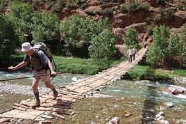
I took this road and track at the beginning of April this year, coming from Beni Mellal. The R302 is paved for part of the way from Ouaouizeght to about 5 km from the Cathédrale, near the village of Tilouguite, then it's a dirt track until Zaouiat Ahansal. I crossed a wadi where water was flowing—about fifteen centimeters deep—and I got through without any issues. I was on a motorcycle, so a 4x4 would have no problem, and the track is very passable. After that, it's paved all the way to Tabant and even further. I stopped for a night near Tabant and then continued toward Demnate.
There is indeed a direct track between Imilchil and Tabant. Up to Anergui, I think it's paved, but beyond that, I'm not sure—I believe it's mostly a dirt track, passing through Adendoun.
The wadi I crossed
Condition of the track—it's excellent overall. Some sections are rougher, but still very passable.
My GPS shows 210 kilometers between Imilchil and Tabant, with about 6 hours of driving.
The Cathédrale rock formation is phenomenal—you get an amazing view when you arrive at the base along the wadi, and then the track takes you up to overlook the rock. It's stunning.
Safe travels!
Yes, it is.
Not always great depending on whether you're coming from the west or the east.
The government wanted to open up villages, but some of the money was embezzled.
So instead of laying xx centimeters of asphalt, the company only put down x. It doesn’t hold up as well...
Édifices religieux : concours de photos amical d'août 2026
Rubrique Jeux Voyages
C'est le moment de voter !
The most direct ones start from the 302 between the cathedral and Zahouia and go up to the Irzhissane plateau. The starting point is here: 31°56'42.1"N 6°05'16.8"W... So yes, that’s the one on your GPS (Tilouguite). PS: There’s a great photo spot in a bend—step back a bit in your 4x4 and take a look... you’ll see (approximately: 31°54'34.2"N 6°03'50.7"W).
Note that now there’s another surprise since the track that used to be a dead end from Zaouiha toward Taghia in the direction of Tourde... now connects (you can also head toward Imilchil). As for Taghia, for better or worse, you can now reach it by car... almost to the foot of Oujdad.
I’m surprised a GPS would suggest this route, but hey, I don’t use those gadgets (just Osmand—it’s enough for me, even if the satellite views aren’t reliable).
Several variations: You can exit before Imilchil at Bouzmou, a small village where the famous Imilchil moussem takes place, or another route that’ll bring you to Oulghazi where the tarmac starts, a bit farther from Imilchil along the Assif Melloul.
You can also reach Tilmi via Tafraout and go back up through Tizi Ouano, Agoudal, etc. Beautiful track and stunning scenery—almost no chance of running into other tourists there. And another new one that leads to Oussikis, so don’t take the wrong track.
There’s also a very old track you can take from a small village (name slipped my mind) between Zahouia and the Tissili n’Imenane pass in a bend. It starts in the wadi and goes up a crazy zigzag climb, but it’s solid—though you’ll pretty much have to navigate by sight afterward (my GPX trace is messy because I was all over the place ^^).
Not sure if GPX traces are shared here, but I’ve got a few...
As Perju said, with a 4x4, the question doesn’t even come up—of course you’ll make it. I won’t tell you what car I did these in...
Can these routes be done year-round? Unlikely, especially now—it’s mountain terrain, and with all the snow and autumn rains, there are probably a few potholes here and there...
I can give you some phone numbers for guys who live in these areas and can provide updates the day you pass through.
Anyway, it’s a beautiful and rarely visited spot.
Qui écoute trop la météo, passe sa vie au bistrot !
I almost forgot, the track mentioned that goes via Anergui is something else but really nice too—it passes through the beautiful gorges of the Assif Melloul and has been almost entirely redone. You’re no longer bothered by the river like before, and it’ll bring you out via Tassent onto the road between El Ksiba and Imilchil...
Around Anergui, if you take the track heading toward Ait Ouhamou, another track is being finished that’ll let you reach the cathedral via the same route from Tilouguite.
Qui écoute trop la météo, passe sa vie au bistrot !
Thanks for all this info. I’m not a big fan of GPS either, so I’ll try to find my way with the Huber Kartographie maps—they seem really detailed.
Road trip in early April, we can’t wait to be there.
Dominique
Hi Olivier,
for now I only have the gmaps track, which is why I’m looking for more detailed info and maps. From Imilchil, you leave the N12 toward Afert, then the track goes through Anergui and Adendoun before joining the N302 at the Cathédrale des Rochers.
Dominique
Ah okay, so this route really isn’t difficult at all. I was surprised when I read your post—I thought the GPS was already showing how to take other tracks, including a new one...
Gmaps—is that Google Maps, the app? If so, it’s completely useless in Morocco for off-road tracks since it won’t show anything...
But if Gmaps does show a route and lets you follow it, that means it’s either paved or an old paved road, no matter what—basically, a route where a 4x4 will never run into any difficulty. Though watch out, because Gmaps can be a real pain with its obsession for the "fastest" route. It might work, but it’s not necessarily the smartest choice... (If it detects another crappier route that saves 0.7 seconds over 800 km, it’ll take it without hesitation.)
Do you know how to use GPX files? I just found my track—following it is super simple. I’ll send it to you by email.
But now I’m wondering—what exactly are you looking for? I think you’re not after the direct track but rather the most well-known and tourist-friendly route, if I’m not mistaken...
If it’s your first time in the area, go for the prettiest road. You can come back for something more adventurous next time... 😇
Without a doubt, the two most beautiful routes are via the Assif Melloul track, facing the cathedral via Anergui—but it has some stiff competition with another track that’s a bit longer but absolutely stunning: the crossing to Tilmi at the foot of Tizi Ouanno. That one will blow you away... I’ve got the GPX track for that too...
Qui écoute trop la météo, passe sa vie au bistrot !
Good call, first time in the Bled!
It's true because for 40 years, from the Sahara (that was a while back...) to the Andean trails, from Sani Pass to the Bolivian salt flats, from the stunning trails of Montana to the Transpyrenees..., we’ve sought out the most well-known and touristy routes , that I’m trying to find routes in Morocco that are a bit more off the beaten path, if that’s still possible.
With over 150 years between us, we need to find alternatives that are a bit more reasonable than solo trails above 4,000 m.
For us, the trail isn’t a goal or a quest for performance but a way to discover all those corners of the world that leave you speechless, for the unlikely encounters in places forgotten by civilization. That’s also why, despite the call of the dunes, I’m put off by the number of camps, photos of quads or other vehicles in the dunes—I’m skipping the Morocco circuit, Merzouga, and the Erg Chegaga.
A fan of paper maps that "speak" to me and that I can’t find for this region of Morocco, I’d still love your GPX tracks (dominique.geraudel@gmail.com).
Have you had any experience with Gandini guides, who seem to be the go-to reference?
Thanks,
Dominique
Hi there, no need for GPS to navigate in Morocco! From the Imilchil region to Agoudal - Ait Hani - Todhra Gorges - Tinghir = paved road the whole way. Ait Bouguemez Valley is paved up to 13 km before Zaouia Ahensal, from Demnate. Imi-n-Fri bridge is paved from Ouazizart to Tilouguite, then a track ready to be paved for about 15 km to reach the "Cathedral." From Bou Trahrar, a track leads to the Ait Bouguemez Valley via the Tizi-n-Ait-Hamed pass (3050m). Watch out for sand with a Duster-type car. With Google Maps, you’ll see the main routes, or check apps like Komoot or OpenRunner to view roads and tracks. Feel free to contact me later. 20 years of cycling in Morocco. Cheers, Rv.
Partant de Marrakech pour la vallée des Aït bougmes (agouti), je voudrai rejoindre boulmane dadès au plus court par la piste depuis agouti. Est ce possible à…
En janvier, nous voulons faire un petit voyage au Maroc et au Sahara Occidental Nous voulons effectuer le trajet Assa jusqu'à Smara en Leibouirat Quelqu'un…
Mi septembre nous partons avec mon ami au Maroc "Casablanca" en voiture! Première fois en voiture et j' aurais souhaité savoir le coût a peu près du gasoil…
Merci de me donner vos avis sur le trajet ci-dessus avec un 4x4 de location: - duree du trajet - difficulte du terrain - usage imperatif du gps Merci d'avance.…
Hi there,
I’m planning a trip to Russia and Mongolia, starting from France.
Crossing the border at Poland/Belarus or Georgia/Russia—other borders seem either closed or complicated.
Tourist visas for 3 months with multiple entries.
Do you have any info on Russian companies that cover a 4x4 vehicle for 3 months, and what prices in rubles or euros you’ve paid?
Which bank did you use for expenses? (EuroMastercard and Visa cards no longer work.)
Regarding Russian SIM cards, a new system called "Gosuslugi" has been introduced. How long did it take you to get one, and what steps did you follow?
Hi there,
We’ll be traveling in January 2027 in a 4x4 with a rooftop tent with our three kids, from Johannesburg to Cape Town. We’ve already booked several campsites in national parks (Golden Gate / Mountain Zebra / Addo Elephant / Garden Route).
We still need to reserve the stretch between De Hoop Nature Reserve and Cape Town. Any suggestions?
We’d love to stay around Cape Town for 5 days to explore the wine route, the peninsula, and do some hikes in Table Mountain.
Any camping recommendations? Or, on the contrary, places to avoid?
Also, we have 2 nights left near Wilderness National Park / Knysna. Any recommendations?
Thanks so much for your help!
For my 60th birthday (yes, I’m jumping the gun a bit!), I’m starting to plan a self-drive trip to Tanzania (in June).
I also considered Zimbabwe but I’m worried it might be a bit chilly at night in June.
I’ve revisited an itinerary I’d thought about before, tweaking it since I’ll have more days to dedicate to this trip. Still no big northern classics for the same reasons as before (too expensive, too crowded, too many tour operators).
Here’s what I’ve got so far:
(Arrival/departure from Kilimanjaro Airport)
Night 1: Arusha
Night 2: Arusha
Night 3: Lake Manyara
Night 4: On the way to Iringa (any ideas???)
Night 5: Iringa
Nights 6–8: Ruaha NP
Nights 9–10: Mikumi NP
Night 11: Bagamoyo
Nights 12–15: Beach
Nights 16–17: Lushoto
Nights 18–19: Mkomazi NP
Night 20: Toward Marangu – eastern Kilimanjaro
Night 21: Western Kilimanjaro
End of trip
All your ideas, tweaks, info, and suggestions on this route are welcome!
I could move one beach night somewhere else if needed.
Also, if you have a car rental company to recommend or thoughts on the bandas rented in the parks, I’m all ears!
Finally, what are the roads like in Ruaha in June? The rental company I’m looking at seems to allow this park with a small 4x4. (Off-limits: Serengeti and Natron)
We’re planning a long-term trip starting in April with our 4x4, beginning in the USA.
We’re still looking for car insurance that covers Canada and the USA.
We’ve read quite a few forums, but we’re hoping for some help (from fellow travelers).
Hi,
we’re planning to visit a park again.
Could you point us toward the camps in Gonarezhou Park?
>We’re traveling completely self-sufficiently.
We love wildlife.
Thanks for any tips you can share!
JP
Hi there, we’ll be in Mozambique in early December 2026 and we’d like to travel from Vilanculos to Beira by car or bus to reach Beira airport. After that, we’re planning to visit Gorongosa National Park before flying back to France from Beira. From what we’ve heard, the road to Beira is tricky, especially at this time of year (start of the rainy season). Could anyone share their thoughts or suggest a solution? Thanks so much for your help!
Anne
Hi there,
I’m heading to Lesotho in a few days and I’m struggling to find info on the best route between Katse Dam and Sehlathebe National Park. There’s a fairly "direct" route from Thaba Tseka, but the roads seem rough, and we’re not exactly 4x4 pros. Anyone have any tips to share? Thanks!
Hi everyone,
We’re heading to Mozambique in October and are looking for either a 4x4 or 4x2 rental in Maputo, or a driver transfer option to reach:
- Ponta Do Ouro
- Tofo
- Vilankulos
The idea is to be self-sufficient for sightseeing and stops while still being able to access certain lodges or beaches that require a 4x2.
Do you have any contacts, addresses, or ideas to share?
Thanks in advance,
Hello,
We're hitting the road again in 2027 to discover new countries and cultures.
Could anyone give me some tips on driving from Ulaanbaatar to Lake Baikal and the route to take?
Thanks, and safe travels to those who are setting off!
We’re planning a 4x4 trip from Belgium to Central Asia, passing through Georgia, Russia, Uzbekistan, Kazakhstan, and Kyrgyzstan.
For these countries, our national insurance obviously doesn’t cover the vehicle, so we’ll need to get local insurance.
Will it be a problem if the vehicle is registered under person A and the national insurance is under person B? Both A and B will be in the vehicle, and both will be listed as drivers on the insurance.
When we get the local insurance, if we again list A and B as drivers, does the order matter? Could we get stuck at the border for this reason?
Hi,
For those who’ve driven on Iceland’s gravel roads in their own or a rented Duster, could you tell me what tires were fitted on the vehicle?
Were they All Terrain tires or more "standard" ones like all-season tires, for example?
Follow-up question: if they were "standard" tires, did that cause any issues on the gravel roads and rough terrain?
Thanks so much for any info you can share.
Best,
Marc
Hi there,
I'm planning a 4x4 road trip from Darwin to Broome with a rooftop tent in July 2026.
I'd like to know if I need to book overnight stops in advance or if I can just wing it and stop wherever I feel like it?
Some evenings, we'd like to stop and make use of campsite facilities (restaurant, shop, showers, toilets).
What do you recommend?
Do I need a permit?
My rough itinerary looks like this:
Darwin - Kakadu
Kakadu - Nitmiluk
Nitmiluk - Kununurra
Kununurra - Purnululu
Purnululu - El Questro
El Questro - Mt Elizabeth - Bell Gorge - Broome
I’m planning a trip to Iceland for next July-August, with a car and tent, and I’m wondering about booking campsites.
From your experience, is it necessary or even essential to book campsites in advance, or do you always manage to find a spot to pitch your tent?
We’ll also have the option to sleep in the car without pitching the tent.
Does that give us the flexibility to stay outside a campsite for a night here and there?
Hi,
I’m planning a road trip in the Middle Atlas, starting and ending in Fez and heading down to the south of Midelt, the Assoul Massif.... We’ll be traveling with two small 4x4s.
I’m looking for detailed maps of this region that include small roads and tracks.
Last year, we had a fantastic road trip in the Anti-Atlas and High Atlas using Erfahren maps, but unfortunately, they don’t cover the area we’re interested in this year.
Thanks for your suggestions!
Dominique
We’re planning a 13-day family road trip in Morocco this July, with six people in a Toyota Prado 4x4 (renting in Marrakech).
We’ll alternate between bivouacking and small hotels/riads depending on the stops.
Here’s the planned route (in this order):
Marrakech
→ Ouarzazate
→ Draa Valley
→ Zagora
→ Erg Chegaga
→ Lake Iriki
→ Foum Zguid
→ Tata
→ Tafraoute
→ Aït Mansour
→ Tiznit
→ Mirleft
→ Taroudant
→ Back to Marrakech
Our goal:
Atlas Mountains + desert + dunes + plateaus + valleys + a bit of coastline.
We’ll cover about 1,700 km in total.
We’re planning:
Bivouacking in the Chegaga/Iriki area
Flexible for the rest (booking the day before or same day)
Sand gear: traction plates, compressor, tow strap, roof rack
Questions:
Is the Zagora → Chegaga → Iriki → Foum Zguid crossing in July doable on our own (single vehicle, no guide)?
Are there any truly technical or risky sections between Chegaga and Iriki?
Does the overall itinerary seem manageable in 13 days without rushing?
Any suggestions for great bivouac spots or particularly interesting stops along this route?
The points on the route are provisional overnight stops. Some spots will include two nights in the same area.
We’re used to off-road driving, but not yet in the Moroccan desert.
Thanks in advance for your feedback and tips! 😊
Good evening
I could use some advice 🙂
Our trip to Namibia is planned for June/July 2026.
We’re struggling a bit with timing and choosing activities for the part of the trip between Sesriem and Brandberg.
Day 1: Sesriem to Mirabib
Day 2: Mirabib to Swakopmund – visit Swakopmund, overnight in Swakopmund
Day 3: Sandwich Harbour – overnight in Swakopmund
Day 4: Kayaking with the seals + the living dunes – overnight in Swakopmund
Day 5: Moon Landscape, Henties Bay + Cape Cross – overnight at White Lady Lodge in Brandberg
Does this itinerary seem realistic to you? Is Cape Cross really worth the trip? If I had to choose between Cape Cross and kayaking with the seals, which would you recommend?
Thanks in advance for your help!
Hélix
My son and I are heading to Georgia this summer to explore the High Caucasus (Svaneti, Kazbek, and Tusheti regions). For this, we’re planning to rent a 4x4.
However, the rental agencies we’ve found prohibit driving on the tracks to Omalo (Tusheti) and/or Ushguli (Svaneti).
Do you know of any agencies in Tbilisi (local and reliable) that allow rented 4x4s to drive on these tracks? If so, which ones?
Hi everyone,
I’m starting to plan an itinerary for September 2027 focused on Zimbabwe and Zambia. I’d love to visit Gonarezhou National Park—I see there are two sectors: the Mwenezi Region in the south and the area around the Runde River in the north. Should I cover both sectors or just focus on the northern region?
For the parks along the Zambezi River, is it better to visit Mana Pools on the Zimbabwe side or Lower Zambezi on the Zambia side?
Thanks in advance for any tips on the parks in these two countries.
Have a great day, everyone.
We’re spending 18 days in New Zealand from 05/04 to 05/21, arriving in QUEENSTOWN and leaving from AUCKLAND.
Any ideas for a road trip that covers the highlights of both islands but only changes hotels every 3–4 nights?
Thanks.
For our trip to Georgia in July, I’d like to rent a 4x4 starting from Tbilisi.
Do you have any rental companies to recommend?
The traditional rentals like Hertz, Avis, etc. seem way overpriced compared to local companies—what do you think? Are they properly insured?
Has anyone here tried Geo Rent Car, Auto 4 Rental, or Sur Price?
Also, I’m looking for info on the condition of the Ushguli–Lentekhi track—is it passable?
Hi everyone,
A well-prepped 4x4, a travel plan across Africa in stages since I’ve got kids to see regularly and work to earn a living.
I’m leaving in November for about a month with the goal of reaching Senegal via Mauritania. I’d love to share this trip with someone who wants to discover Mauritania and a bit of Senegal... and also experience life on board a 4x4 in the desert or bush, sometimes sleeping in the vehicle or in hostels/small hotels for comfort. I want to share this rediscovery because two’s better than one!
Just traveling, exploring, and living! !
I’m planning to explore Argentine and Chilean Patagonia for a month in December 2019.
I’m looking for a rental company (or several) that offers single-cab 4x4 pick-ups with a fitted camper cell for two people. I’m specifically after a vehicle with an indoor shower for extra comfort ;)
So, no vans—at least not from the rental companies I’ve seen so far.
While browsing the forum, I came across the Chilean rental company Holiday Rent. But do you have any recommendations for Argentine rentals?
Because, if I can’t return the vehicle in the same city as pickup, I’d prefer—and it’d likely be cheaper—to at least return it in the same country.
I’m traveling through Argentina and Chile (as well as Paraguay and Uruguay) with a 2019 Toyota Hilux Euro 6. Could anyone tell me if the local diesel is suitable for its engine, or if I need to take any special precautions (like adding an additive, for example) for these countries?
I’d also like to know if driving at high altitudes is possible, and up to what elevation—or if I should worry about the vehicle going into limp mode?
If that happens, what should I do?
Hi there,
Can you tell me if the road between Zagora and M'Gouna is easy or difficult for a 4x4? How much time and how many kilometers should I plan for? I’m traveling in May.
Thanks!
Hi there,
My trip to South Africa is starting to take shape.
However, I'm struggling to figure out the route through Kruger Park. I can't seem to find the information I need about getting around.
Coming from the south, I plan to arrive on Day 1 in the early afternoon at Malelane or Crocodile Bridge.
Do some shopping in Malelane (or Crocodile Bridge main area) and stay overnight outside the park.
Leave on Day 2 at 5 AM for the park. Explore the southern part of the park.
Stay overnight around Skukuza or Lower Sabie. (We don’t want to stay in one of the park’s big camps. We’re looking for a lodge around 200 €.
Head out on Day 3 for a self-drive safari, maybe as far as Orpen.
We’d like to stay in a private reserve on nights 4 and 5.
We’re not sure which one or how to get into a private reserve. Do we need to exit Kruger Park?
On Day 5, we’d like to leave to visit Blyde Canyon (on Day 6).
I’m planning to leave Morocco for the summer but want to leave my 4x4 there to avoid exceeding the famous 6-month limit. I’d like to park it in one of the two Spanish enclaves (Ceuta or Melilla).
Does anyone know of people or companies that handle long-term parking (preferably secure) in either place?
Once the car is parked, what’s the best way to get back to France using public transport?
Is the nearest airport Tanger from Ceuta?...
How do I get there easily, etc. etc.
hello! I’d like to go to Kazakhstan and rent a fitted 4x4 locally so I can drive off-road trails and sleep inside the vehicle... could anyone share some local rental company addresses, please? Thanks! !

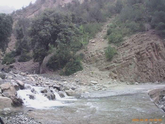 The wadi I crossed
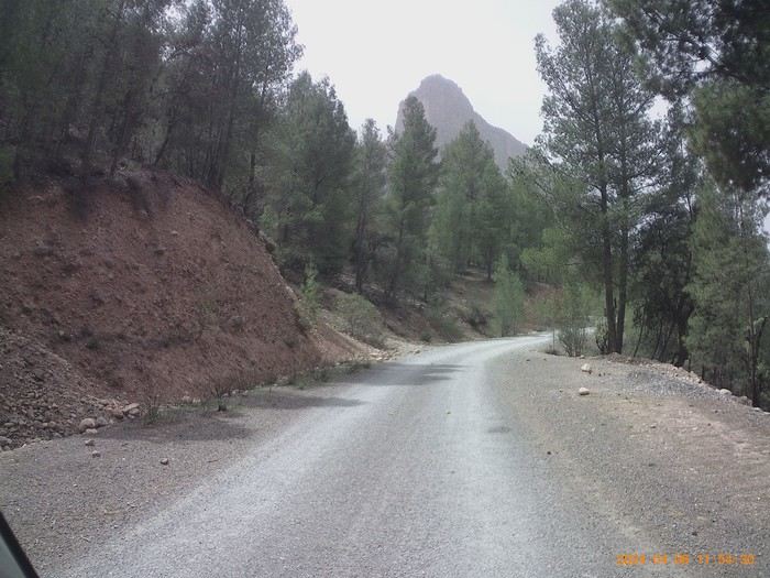 Condition of the track—it's excellent overall. Some sections are rougher, but still very passable.