Age (80+) is making us stop our 20 years of bike travel (a good part of Europe), so we're selling (together or separately) our two touring bikes and switching to an electric city bike.🤪
They're already listed on a big national multi-product sales site, but potential buyers don't seem to know what a touring bike equipped with a Rohloff is....🙂
So my question: Do you know of a site where I'd have a better chance?😉
They're ROSE VTC bikes, Black Water III models from 2012.
Bicycle travel
Rubrique dédiée à ceux qui aiment voyager à vélo. Cyclotourisme, conseils, suggestions, équipement, etc.
Showing 31–60 of 15,593 discussions.
Many threads here are in French, the community’s main language. English translations are added over time.
It’s never too late to live intensely.
I’m Guy, I’ve passed 70, and I’m looking for a female travel companion for an extraordinary adventure aboard OTONOMI—a solar-powered tandem I built with my own hands over two years.
My past is that of an unrepentant traveler: crossing the Atlantic in an ultralight aircraft, swimming across channels, and a high-level sailing record in major transatlantic races... OTONOMI isn’t a retiree’s whim—it’s the final chapter of a life of adventure, perhaps the most beautiful one.
Departure at the end of May. Route: Europe to Baku, crossing the Caspian by ferry, then Turkmenistan, Uzbekistan, Tajikistan, the Pamir, Kyrgyzstan, and return via Kazakhstan. At least 3-4 months.
No need to be athletic—a session of *longe côte* (coastal walking) requires more physical effort than a full day on OTONOMI. You don’t even have to pedal at all.
OTONOMI tows a foldable solar-powered caravan trailer—camping under the stars or staying in small local hotels, depending on your mood. Road expenses are shared simply.
I’m looking for a free-spirited woman, curious, passionate about genuine encounters and wide-open spaces—appearance or insecurities don’t matter. Just that flame still burning inside you.
A real-life test run is planned before departure—so we can meet naturally, without pressure.
📩 guy.otonomi@outlook.fr
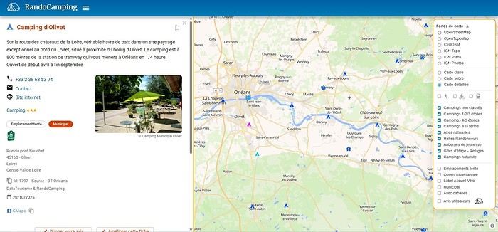
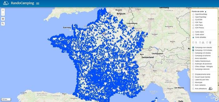
The RandoCamping site is free for users and hosts.
Its goal is to help trekkers find accommodations (usually by the night) all across France and to promote hosts who welcome trekkers satisfactorily.
Check it out here: https://randocamping.touteslatitudes.fr
The site is collaborative and supported by associations like Cyclo-Camping International or AF3V.
It lets you plan a trip or trek (on foot or by bike) by searching for accommodations along a route. The accommodations come from the DataTourisme platform (which aggregates information from Tourist Offices) and from users (trekkers & hosts).
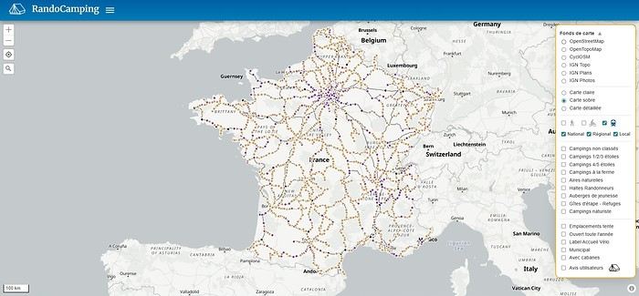
Train lines and passenger stations are also listed. Clicking on a station can show you (if the data is available) how accessible the platforms are with a non-dismantled bike. Bike and hiking routes come from Waymarked Trails (which is based on OpenStreetMap).
You can find more details about the site’s features on this page (version 1.0): https://randovelo.touteslatitudes.fr/randocamping-v1/
Its goal is to help trekkers find accommodations (usually by the night) all across France and to promote hosts who welcome trekkers satisfactorily.
Check it out here: https://randocamping.touteslatitudes.fr
The site is collaborative and supported by associations like Cyclo-Camping International or AF3V.
It lets you plan a trip or trek (on foot or by bike) by searching for accommodations along a route. The accommodations come from the DataTourisme platform (which aggregates information from Tourist Offices) and from users (trekkers & hosts).
Train lines and passenger stations are also listed. Clicking on a station can show you (if the data is available) how accessible the platforms are with a non-dismantled bike. Bike and hiking routes come from Waymarked Trails (which is based on OpenStreetMap).
You can find more details about the site’s features on this page (version 1.0): https://randovelo.touteslatitudes.fr/randocamping-v1/
Hello young cycling enthusiasts,
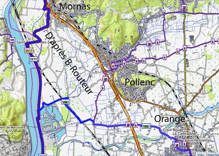
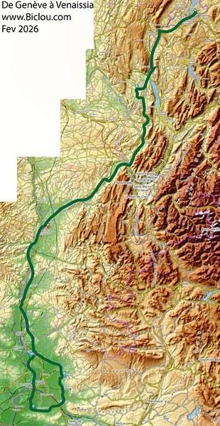
I’m starting a thread about the bike route known as venaissia.
Claudio took advantage of this February 2026’s mild weather to check out what it looks like.
Here we go—story and photos coming soon: http://cbandiera.free.fr/recits/2026-venaissia/
The plan was to go from Faverges to Cavaillon and explore the Via Venaissia a bit. A crazy idea? Maybe, but don’t forget that the month of February—"februare" in Latin—means "to purify," so it’s the Month of the Lupercalia, a Roman festival that was a purification rite. So, to purify himself after the feasts of the Saturnalia, Claudio set off (from an oak tree, no less) to pedal south.
He returned a little soaked but alive: The stages were as follows: (to be continued)
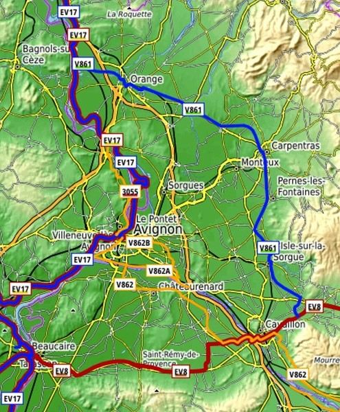 overall impression:
good signage, but Claudio still managed to get lost in cities like Orange and Carpentras...
Cavaillon... got lost several times, but thanks to the map and GPS, he got back on track...
Nice route, sometimes a bit boring, quiet, deserted (normal given the weather), threatening skies, but he escaped the rain.
overall impression:
good signage, but Claudio still managed to get lost in cities like Orange and Carpentras...
Cavaillon... got lost several times, but thanks to the map and GPS, he got back on track...
Nice route, sometimes a bit boring, quiet, deserted (normal given the weather), threatening skies, but he escaped the rain.
Claudio took advantage of this February 2026’s mild weather to check out what it looks like.
Here we go—story and photos coming soon: http://cbandiera.free.fr/recits/2026-venaissia/
The plan was to go from Faverges to Cavaillon and explore the Via Venaissia a bit. A crazy idea? Maybe, but don’t forget that the month of February—"februare" in Latin—means "to purify," so it’s the Month of the Lupercalia, a Roman festival that was a purification rite. So, to purify himself after the feasts of the Saturnalia, Claudio set off (from an oak tree, no less) to pedal south.
He returned a little soaked but alive: The stages were as follows: (to be continued)
overall impression:
good signage, but Claudio still managed to get lost in cities like Orange and Carpentras...
Cavaillon... got lost several times, but thanks to the map and GPS, he got back on track...
Nice route, sometimes a bit boring, quiet, deserted (normal given the weather), threatening skies, but he escaped the rain.Hi,
A friend is looking for a bike to embark on a long trip, but the issue is he’s only 1.55m tall.
In itself, that’s not a problem 😏, except that finding an XS-sized touring bike isn’t easy.
Some start at 1.55m, but it’s still a bit extreme.
If anyone knows of brands or models that might work...
Thanks in advance
I'm planning a 3-day weekend with my wife on this cycle path. The articles about this route are old, so if anyone has traveled it recently and can give me an update on its condition, that'd be great. We're riding 1994 ROCKRIDER 340 mountain bikes but with 1.5-inch tires suited for road touring—will that work, or should I switch back to MTB tires? Thanks for your replies!
A bit disappointed with the forum's revival—there isn’t much activity or shared travel stories anymore.
A bit disappointed with the forum's revival—there isn’t much activity or shared travel stories anymore.
Bonjour,
Ce n'est encore qu'un projet : Nous envisageons ma femme et moi de faire un voyage à vélo au Danemark .
La période serait juillet 2020, la durée: 3 bonnes semaines; de préférence faire une boucle, pour éviter de voir les mêmes paysages et villes ; enfin nous pratiquons le camping .
Nous avons nos propres vélos bien équipés et une remorque mono roue "Bob" .
A priori, nous partirons et reviendrons à Copenhague . Faisant des étapes de 40 à 60 km , laissant les temps de visiter les villes et régions .
Par le bouche à oreille nous savons que le Danemark est l'autre Pays du vélo, donc nous n'aurons pas de soucis pour pratiquer les voies cyclables .
Par contre côté documents, nous sommes un peu perdus, et ne connaissant pas du tout le Pays, nous ne savons pas ce qui est le plus intéressant à voir et à parcourir .
Nous avons la carte double Dänemark au 1/150 000° de freytag et berndt ; on y voit les repères cyclables et les campings ( c'est déjà bien !) mais ce n'est guère pratique à vélo .
Notre expérience aux Pays-bas avec des cartes format "routières" vite délitées avec la pluie a montré les limites de ces documents ...
Y a-t-il des documents plus pratiques ? genre guide vélo comme on en a en France ou pour les vélo routes européennes ?
Y-a-t-il un système de repérage des n° de vélo routes comme en Hollande ?
Et nous sommes preneurs bien sur de toutes les infos pratiques comme le coût de la vie, des campings, l'accueil ( qui j'en suis persuadé est excellent) , les aléas météo, les côtes, le vent (souvenirs des Pays-bas !!!) , et bien sur vos coups de coeur ...
Merci d'avance aux contributeurs ;
Pierre et Dominique de Lorient
Hello,
I’m 72 years old and I’m flying to Beijing from Rome on March 26th. My return is planned for May 11th from Ulaanbaatar to Frankfurt. I’m thinking of buying a cheap bike in Beijing and riding to Hohhot, stopping to see the Great Wall of China along the way. From Hohhot, I’ll take the train to cross the border and get off at Sainshand in Mongolia, then continue to Ulaanbaatar. Can anyone give me some tips? Thanks!
Gérald
Hi there,
I’m planning to cycle the Vélodyssée from Hendaye to Saint-Brevin in July 2026. My issue: how do I get to Hendaye with my bike? FlixBus doesn’t take bikes, and SNCF is complicated. Any ideas? Has anyone got a solution to suggest? Thanks in advance! Cheers, Patrig
I’m planning to cycle the Vélodyssée from Hendaye to Saint-Brevin in July 2026. My issue: how do I get to Hendaye with my bike? FlixBus doesn’t take bikes, and SNCF is complicated. Any ideas? Has anyone got a solution to suggest? Thanks in advance! Cheers, Patrig
Hi there,
I want to film my bike trip from Lille all the way to Norway.
Any tips on how to mount my GoPro, other than on my helmet or a selfie stick?
I was thinking about the handlebars, but my bag might block the view.
I’m open to all ideas—thanks a bunch and have a great evening!
Boujour,
L'été dernier j'ai parcouru la vallée du Lot et du Célé à vélo . Nous étions 2 couples, en "mode camping", vélos vtc (sauf 1 vélo route à pneus pas vtc du tout (!) + une remorque Bob . Le parcours s'est fait 1° quinzaine de juillet en un peu moins de 15 jours ( se préservant du temps pour visiter ) Le total au compteur étant de 550 km. Départ de Aiguillon sur le Lot ; arrivée à St-Geniez d'Olt . Ce fut un très grand plaisir . D'abord, un grand merci à tous ceux qui nous ont permis de concocter ce voyage par tous les renseignements, coups de cœur et guides pratiques qu'ils ont bien voulu nous communiquer, ils sont nombreux et certains se reconnaitront (un Jakez de Bretagne, un facteur de la région etc..) Un grand projet semblait avoir été mis en place mais depuis 2011, plus grand chose de concret sauf jusqu'à Cahors ( véloroute fléchée) . Que cela ne retienne personne ! Ca vaut le coup ! En retour des bons tuyaux reçus, je suis près à renseigner tous ceux qui envisageraient de faire le même chemin : itinéraire, étapes état des routes et trafic, campings, coups de cœur et autres . Cordialement
Pierre de Lorient
Hi there,
We’re heading to three islands in March (Paros, Milos, and Sifnos). Given their small size and lack of major elevation, we’d love to explore them by bike. However, I can’t find any bike rental shops on any of these islands. Has anyone done this before and have any recommendations or addresses?
Thanks so much in advance!
Hi there! Every year, we go on a cycling trip abroad with panniers, lasting about two weeks. We stay in step lodgings, guesthouses, and the like. We mostly take small roads and really enjoyed northern Montenegro and Albania last year.
We’d love to hear from anyone who’s cycled in these countries before: tips on finding quiet roads, highlights of the regions we’ll pass through, how welcoming the locals are, and so on. Thanks in advance for any replies or exchanges!
We’d love to hear from anyone who’s cycled in these countries before: tips on finding quiet roads, highlights of the regions we’ll pass through, how welcoming the locals are, and so on. Thanks in advance for any replies or exchanges!
Hi everyone,
I’m planning a cycling trip in Algeria and looking for concrete firsthand accounts from cyclists who’ve recently traveled there (or residents who know the terrain well). My goal is to map out a realistic 2–4 week itinerary that prioritizes discovery, safety, and solid water/bivouac management.
My profile and gear
Semi-bivouac autonomous cyclist (light tent + sleeping bag + stove), with the option of simple accommodations in towns.
All-road/gravel bike with a rear rack, 40–45 mm tires (I can go up to 47–50 mm if needed).
Compact drivetrain with a small gear range for climbing while loaded.
Modular water capacity of 4–7 liters (soft flasks + bottles), plus a filter and purification tablets as backup.
Navigation via offline maps + GPS, GPX tracks if available.
Planned period
Late winter/early spring (timing to be refined based on your feedback about weather, wind, and day/night temperature swings). I’d love a seasonal breakdown: which areas are more pleasant/rideable during this time? Are there zones to avoid while others become ideal?
Preferred itinerary style
High plateaus and accessible Saharan fringes for a loaded bike, alternating between secondary roads and rideable tracks.
Moderate pace (60–90 km/day depending on terrain and wind), with stops in resource towns to restock, shower, and rest.
Safety and logistics (water/supplies) take priority over pure athletic performance.
My specific questions for those who’ve cycled in Algeria 1) Routes and areas
Which roads/tracks did you enjoy for their scenery and interest without being too rough for a loaded gravel bike?
If you’ve ridden the high plateaus: which connections do you recommend to avoid traffic and stick to small roads?
Saharan fringes: which sections are realistic for partial autonomy (reasonably spaced water points, rideable tracks, not too much soft sand)?
Areas to avoid by bike (recently) due to security, road conditions, katabatic winds, construction, etc.?
2) Water and supplies
How frequent were water points on your routes: reliable wells? taps? sources in towns/villages?
In “desert” sections, how many liters did you carry between secure points? Does a 6–7 L capacity seem comfortable, or should I aim for more on certain stretches?
Food: small shops, markets, availability of basics (semolina, sardines, dates, biscuits, powdered milk, etc.) — how often can you reasonably restock?
Filtration: did a filter + tablets suffice? Are there areas where you’d advise against filtering from unprotected wells?
3) Bivouacking and accommodations
Tolerance for discreet bivouacking (far from dwellings, leave-no-trace): recent experiences?
Simple alternatives: guesthouses, small hotels/hostels, campgrounds (if any), municipal lodgings?
Practical stopover towns for restocking, resting, and securing your bike overnight: reliable spots or neighborhoods to prioritize/avoid?
4) Roads, tracks, and weather
Road surface quality on secondary routes: generally decent or highly variable?
Tracks: rideable (compact gravel, laterite) or sometimes sand/washboard? At what tire width would you recommend switching (45 vs. 50 mm)?
Prevailing winds this season: direction, strength, most exposed hours; do you adjust your departures to ride “before the wind” in the morning?
Temperatures: day/night range; sun protection (long gloves, buff, sunscreen, sunglasses), managing nighttime cold at altitude or in the open desert.
5) Safety, formalities, and connectivity
Recently discouraged zones (please note the date if possible).
Roadside checks: which documents to keep handy; are there specific registrations or declarations required upon arrival or when moving between wilayas?
Local SIM/data: which operators work well on the routes you took; tips for recharging/buying credit.
Useful apps/maps on the ground (and reliable offline maps) for locating water, grocery stores, garages, accommodations, rideable segments, etc.
Bike security: how did you handle anti-theft and parking during errands/overnight stays?
6) Gear and adjustments
Recommended minimum gearing for loaded climbs on local roads/tracks.
Ideal tire width and casing (puncture resistance on gravel and rocks).
“Sweet spot” water capacity based on your experience (and tips: frame bags, extra bottles on the fork, bladders in frame bags, etc.).
Maintenance: dust/sand — greases/seals, drivetrain cleaning frequency, breathable filters, protective socks for zipped panniers.
Sample itinerary outline (to validate with your feedback)
Week 1: Arrival, adjustments, high plateaus, linking resource towns to get into the rhythm, test supplies and water.
Week 2: Accessible Saharan fringes, alternating road/track, nights in discreet bivouac when possible + simple accommodations every 3–4 days.
Week 3–4 (optional): Extend toward a second Saharan area or head back to a more temperate zone depending on weather/wind, prioritizing routes known to cyclists.
If you have GPX tracks (even partial), waypoints (water, grocery stores, accommodations), or a travel journal with dates, I’d love to see them. Dated info (year/month) will help me weigh what may have changed recently.
What I can share in return
After the trip, I’ll publish a detailed report with:
Final itinerary + cleaned GPX tracks,
List of confirmed water points and open supply spots,
Gear review (tires, gearing, water capacity),
Notes on bivouacking/accommodations and safety,
Budget and daily distances, to help future travelers.
Thanks in advance for your tips, warnings, good addresses, and updated feedback. Your experience is invaluable for planning a safe, smooth, and enjoyable cycling route in Algeria. Happy trails! 🚴
I’m planning a journey of about 2500 km starting from San Pedro de Atacama (duration: max. 2 months). This trip, almost entirely on remote trails, promises to be an extraordinary adventure.
Highlights of the trip - Crossing the Florido Desert (during the blooming season: October 15–30) - Hiking ascents of legendary volcanoes: - Ojos del Salado (6879 m) - Llullaillaco (6739 m) - Uturuncu (6008 m, with 5820 m reachable by mountain bike!) - A 300 km stage through the heart of the desert, with no resupply or habitation: the ultimate experience of solitude and self-transcendence.
Practical details - Daily distance: max. 100 km and 1000 m elevation gain per day - Average altitude: 4000 m (between 3500 and 5000 m) - Temperatures: ~15 °C during the day, down to -25 °C at night (in a tent) - Accommodation: ~50% in villages (with locals or small hostels), ~50% camping
Estimated budget - 1400 € for the flight ticket (including bike supplement) - 1000 € for on-the-ground expenses
Required equipment - Fatbike (essential for deep sand) - -25 °C comfort sleeping bag - Single-wheel trailer (indispensable for these tough terrains)
My experience In 2022, I completed a similar 1200 km trip north of San Pedro de Atacama: - Full crossing of the Salar de Uyuni (170 km) - Ascents of the Ollague (5868 m) and Aucanquilcha (6176 m) volcanoes - Two 200 km stages with no resupply or human presence Videos available for a glimpse of the adventure: - Atacama Crossing 2022 - Part 1 - Atacama Crossing 2022 - Part 2
Next steps If this adventure interests you, I suggest: 1. A first phone call to get to know each other 2. A meet-up over a drink or a test ride in the Bardenas Reales (similar terrain, and I live 100 km away)
Don’t hesitate to contact me for more info or to discuss the details!
Hi there,
My friend and I are planning to bike down to Tierra del Fuego starting from Santiago, Chile, in early February. The big question is: "Is it possible to find decent and reasonably priced bikes in Santiago?" Are there local resale sites like Leboncoin, or any second-hand spots worth knowing about there? If anyone’s done this before, I’d love to hear your tips! ;)
Thanks! !
Hi there,
We're thinking of cycling from Lisbon to Vila Real de Santo António in March.
Staying at campsites along the way.
I have two logistics questions:
1) Where to leave the van in Lisbon? Would it be okay to leave it a bit outside Lisbon if needed?
2) Can we take the train back from Vila Real de Santo António to Lisbon with our bikes?
Thanks for any insights!
Momo
Good evening,
We’re planning a cycling tour in Denmark and I’m figuring out how to get there. We have electric mountain bikes (and since I’m really happy with mine, I’d prefer not to rent bikes there). We have 9 days.
- I looked into trains, but the prices aren’t great, and I’m worried we won’t always be able to take our bikes. Packing them in a bag and disassembling them seems overwhelming, especially given how big mine is.
- The Flexibus: we’d have to go through Paris from Lyon, which would waste a lot of time.
- Flying? It might not be more expensive than the train.
- We have a camper van, and I’m wondering if that’s an option. Do you know if you can park your vehicle for a week in a parking lot? I get the impression that parking time is limited. Thanks for your advice! Have a great evening,
Sandrine
I have 5 months left to prepare for the most ambitious project of my life...
In 5 months, I’ll hit the road, heading to Nepal. Not by plane. Not by train. But by bike.
13,000 km, 18 countries crossed. Powered only by my legs, my will, and a dream.
This journey isn’t just a physical challenge. It’s:
🌍 A human and cultural adventure, meeting locals, landscapes, and traditions. 🌱 A meaningful project: discussing climate change and, above all, listening to those who experience it daily. 🔥 An inner quest, to push my limits and inspire others to step out of their comfort zones. A message of hope for self-discovery.
I have 20 weeks left to: ✅ Finalize my route ✅ Gather the budget and equipment ✅ Sort out the logistics ✅ And most importantly… find committed sponsors to bring this adventure to life.
Any help is welcome!
Tout est dans le titre, j'ai 70 ans, voilà 5 ans que je voyage en vélo (tente et popote). Statistiquement, j'en ai pour combien d'année encore, histoire de planifier mes destinations pour tout voir (enfin presque)?
Question 1/2 réaliste, 1/2 humoristique
Pour faire simple, quel âge avez vous les séniors encore en activité vélotouristique. Et quels sont vos plus gros problèmes?
Moi je suis en bonne forme physique, bien qu'ayant baissé en 5 ans, ma vitesse de croisière de 3 à 4 km/h.
Mais l'arthrose (hanche) commence à me poser des problèmes pour enjamber le cadre.
Good evening,
I’m planning a solo bike road trip along the EuroVelo 6, starting from Orléans all the way to Budapest, beginning May 1st, 2026!
Question: Have any of you used the Warmshowers site, and if so, I’d love to hear your thoughts on using this app—whether responses to hosting requests are generally satisfying, especially for the different countries I’ll be crossing!
Thanks in advance for your tips!
Philippe
Hi everyone, could someone give me info on the track that starts from Tafraout toward M’harch Pass and then continues to Mcissi to join the national road heading west to Alnif? I’m planning to go in April 2025 by gravel bike/MTB. Is it doable? Is there a lot of soft sand??? How many km???? Thanks for any tips, and happy end of the year to all! Best, Rv.
Hi there,
I’d like to cycle around Guadeloupe during the Christmas holidays. I was wondering if it’s dangerous, if it’s easy to rent a bike, and to find accommodation along the way? Thanks!
Hey fellow cyclists,
Cyclists on trails, paths, or greenways—why do so few (if any) of you use your bells to warn walkers, runners, and other pedestrians when they’re moving in the same direction as you?
I exercise every day (brisk walking) among you in France and abroad, and it’s something I’ve noticed—often with a few scares (and I’m guessing some accidents between cyclists or with pedestrians).
Personally, I always stick to the rules, walking on the left (facing traffic) so I can see you coming, but not everyone does that—neither pedestrians nor cyclists, and let’s be honest, it’s a bit of a free-for-all. 🤪
Your bikes make little to no noise, so why take risks and put others at risk too?
A quick, light *ding-ding* would be enough to warn people—what do you think? 😅
Hi everyone,
After a break of a few years, I’m heading back to Madagascar this October. I’d like to travel from Diego to Maroantsetra via Cap Masoala as much as possible by bike—it’s my favorite way to travel. My questions: for the return trip to Diego once I’m in Maroantsetra, is there a possibility to take a flight, since the road option only starts much further south than Tamatave? Or where can I rent or buy a decent bike between Diego and Cap Masoala? For this bike trip, I’m open to any info—I love traveling rough. Someone might even want to join me on this adventure.
After that, I’d also like info on the northeast part (Mozambique Channel side) of Diego, which I’d like to explore by bike as well.
Thanks, and feel free to share any tips—just skip the paternalistic safety advice. Laurent
After that, I’d also like info on the northeast part (Mozambique Channel side) of Diego, which I’d like to explore by bike as well.
Thanks, and feel free to share any tips—just skip the paternalistic safety advice. Laurent
Hi there,
Has anyone here cycled in the Canary Islands in August? Is it not too hot? Not too crowded on the roads?
Thanks
Hi everyone here who loves cycling,
I’m planning a 5-week trip next January in Uganda: a little tour of 1,200 to 1,500 km crossing the most beautiful spots and reserves in the country. Route to be defined together.
I’m looking for someone to join me.
Interested? Nicolas (72 years old)
Travel site: nicolas.saulnier.free.fr
Interested? Nicolas (72 years old)
Travel site: nicolas.saulnier.free.fr
Hi everyone,
I’m planning a bike trip to cycle around the Baltic Sea (gravel). Starting from Rostock. I’d love to hear from any cyclists who’ve ridden through the countries involved—especially tips on wild camping spots, must-see areas, and where to stock up on supplies, etc.
Thanks in advance!
I’m planning a bike trip to cycle around the Baltic Sea (gravel). Starting from Rostock. I’d love to hear from any cyclists who’ve ridden through the countries involved—especially tips on wild camping spots, must-see areas, and where to stock up on supplies, etc.
Thanks in advance!
Hi there,
I got a handlebar bag for my bike with a KlickFix system and a Galaxy Tab A tablet. I can fit the tablet into the waterproof transparent pouch on the bag—it’s absolutely awesome, I’ve got my dashboard right on the handlebar! I’d like to use Locus Map for geolocation and create a route from Nantes to Saint-Fiacre-sur-Maine. On my PC, with Locus Map, I see the interface on the left to create a planned route (like in the red-framed screenshot below). But on my tablet (using the app), I can’t find the interface to create a planned route from point A to B like I can on the PC. I need help figuring out how to create a route from A to B on my tablet with Locus Map—I know how to find and download a GPX file, but for Nantes to Saint-Fiacre-sur-Maine, there’s no GPX file available online. Also, does anyone know how to remove the ads on Locus Map?
Thanks in advance—David
Hi there,
I’m planning to cycle the EuroVelo 8 route from Nice to Izmir in Turkey (about 2,500 km), but I’m not finding much info or tips for this itinerary.
I’d like to leave at the end of September and complete the route in a max of 2 months, as self-sufficiently as possible (I have a tent, sleeping bag, and camping cookware).
Is this a good idea (will it be too cold starting in October)?
Are there any precautions I should take? Any areas to avoid? Since multiple countries are involved.
And are there any places worth visiting that aren’t on the main route?
I’m used to cycle touring in France but not abroad, so I’d appreciate any tips!
Thanks in advance.