Skip to content
Aveyron

Travel guide · France

Aveyron

★ 3 · last edited Aug 7, 2020 · 3 versions

Like most of its neighbors, Aveyron is a predominantly rural department that will delight nature lovers with its rocky plateaus (Causses, Larzac...), gorges, and deep valleys. It also boasts a rich cultural heritage with its many medieval towns and Templar cities, not to mention its ten communes labeled "Plus Beaux Villages de France."

Overview

Belcastel, Aveyron, France
Belcastel, Aveyron, France · © VoyageForum

Key Facts

  • Type of place: department.
  • Location: in the southern Massif Central.
  • Department code: 12.
  • Bordering departments: Cantal, Gard, Hérault, Lot, Lozère, Tarn, and Tarn-et-Garonne.
  • Sub-prefectures: Millau and Villefranche-de-Rouergue.
  • Number of communes: 285.
  • Population: 278,644 inhabitants (2014).
  • Area: 8,735 km².
  • Highest point: Les Cazalets (1,463 m).
  • Lowest point:
  • Coastline: 0 km; no maritime access.
  • Highlights (out of ): Nature ; Adventure ; Culture ; Relaxation/Holidays /

History of Aveyron

Geography and Environment

Culture and Economy

What to See in Aveyron

Like most of its neighbors, Aveyron is a predominantly rural department that will delight nature lovers with its rocky plateaus (Causses, Larzac...), gorges, and deep valleys. In addition, it boasts a rich cultural heritage with its many medieval towns and Templar cities, not to mention its ten communes labeled "Plus Beaux Villages de France."

What to Do in Aveyron

- Swimming and water activities: no beaches here, but lakes and equipped water sports centers (see details).

- Horseback riding: equestrian centers as well as opportunities for rides and hikes for all levels and durations (see details).

- Cycling: given its landscape, villages, and quiet roads, the region is highly popular with cycling enthusiasts (see details).

- White-water sports: canoeing, kayaking, paddleboarding, rafting, canyoning, and white-water swimming—the rivers of Aveyron offer plenty of options for fans (see details).

- Climbing and caving: Aveyron has its share of climbing sites, plus via ferrata options. Underground caves can also be explored with guidance (see details).

- Golf: a few golf (and mini-golf) courses available in the department (see details).

- Fishing: the Aveyron countryside has 7,000 km of rivers and around forty lakes. Trout, pike, and carp are among the catches (see details).

- Hiking: the department is a paradise for walkers, with 1,250 km of long-distance trails (GR 65 and 71) and 5,300 km of walking and hiking paths. Several trail-running routes are also available (see details).

- Wellness: spas and balneotherapy in Aveyron (see details).

- Winter sports: Aveyron isn’t the first department that comes to mind for winter activities, but there are two ski resorts in Aubrac offering ski touring, snowshoeing, and dog sledding (see details).

- Mountain biking: in addition to cycling, on marked trails or specific routes (see details).

- From the sky: Aveyron seen from above—hot-air balloon, microlight, paragliding, hang gliding, parachuting, or gliding. Bungee jumping is also an option (see details).

Climate and Weather

Due to its geographical position, Aveyron sits at a "climatic crossroads." It can be divided into three zones: the west has a mild oceanic climate, the north has a harsher mountain climate, and the south has a Mediterranean climate with cold winters and dry summers.
Transport

Getting There

Getting Around

Accommodation

Food

Further Information

Loc-Dieu Abbey

This is a Cistercian abbey near Villefranche-de-Rouergue.

Overview of the Abbey

This is a Cistercian abbey near Villefranche-de-Rouergue.

  • Tourist interest: (worth a stop if you are in the area).

History of the Abbey

What to See and Do

Practical Information

  • Location:
  • Opening hours:
  • Admission:
  • How to get there:

Nearby Attractions

  1. == En complément
View guide page: Loc-Dieu Abbey

Sylvanès Abbey

A 12th-century Cistercian abbey in the southern part of the department, known for hosting various cultural and spiritual events each year. Right next to it, you can also see a Russian Orthodox church.

Overview of the Abbey

This 12th-century Cistercian abbey in the southern part of the Aveyron department is known for hosting various cultural and spiritual events each year. Right next to it, you can also see a Russian Orthodox church.

  • Tourist interest: (worth a stop if you are in the area).

History of the Abbey

What to See and Do

Practical Information

  • Location:
  • Address: Le Bourg, 12360 Sylvanès.
  • Opening hours:
  • Price:
  • How to get there:

What to See Nearby

  1. == En complément
View guide page: Sylvanès Abbey

Belcastel

With its well-restored old fortress and surrounding stone houses, this village—certified as one of the "Most Beautiful Villages of France"—attracts quite a few visitors in season.

Overview of Belcastel

With its well-restored old fortress and surrounding stone houses, Belcastel, certified as one of the "Most Beautiful Villages of France," attracts quite a few visitors in season.

Key Details

  • Type of place: village.
  • Tourist interest: (worth seeing).
  • Distances:
  • Local time: Heure : 18286.
  • Population: 192 inhabitants (2014).
  • Area: 10.74 km².
  • Altitude: from 391 to 707 m.

History of Belcastel

What to See and Do in Belcastel

A 15th-century church, a perched medieval castle, an old bridge over the Aveyron, steep alleys, and stone houses give the village its distinct charm and represent its main tourist appeal.

Forge House and Traditional Trades
In the village's restored former forge, the various trades linked to 19th-century rural life.
Roc d'Anglars
500 m upstream from the village, these are the ruins of a 5th-century fort.

In the Surrounding Area

Climate and Weather in Belcastel

Transportation

Getting There

Getting Around

Accommodation

Dining

Useful Addresses

Additional Information

View guide page: Belcastel

Forge House and Traditional Trades

In the village's restored former forge, the various trades linked to 19th-century rural life.

Overview of the Site

In the village's restored former forge, the various trades linked to 19th-century rural life.

  • Tourist interest: (worth a stop if you are in the area).

History of the Forge House

Collections on Display

Practical Information

  • Location:
  • Address: 12390 Belcastel, France.
  • Opening hours:
  • Admission:
  • How to get there:

Nearby Attractions

  1. == In addition
View guide page: Forge House and Traditional Trades

Roc d'Anglars

500 m upstream from the village, these are the ruins of a 5th-century fort.

Overview of Roc d'Anglars

500 m upstream from the village, these are the ruins of a 5th-century fort. Note that the site shares its name with a cliff in Tarn-et-Garonne, which is a well-known climbing spot.

  • Type of site: historic remains.
  • Tourist interest: (worth a stop if you are in the area).
  • Features:
  • Area:
  • Altitude:

History of Roc d'Anglars

What to see and do

Practical information

  • Location:
  • Opening hours:
  • Admission fee:
  • How to get there:

Nearby attractions

  1. == En complément
View guide page: Roc d'Anglars

Bez-Bédène

Perched on a rocky spur and surrounded by cliffs, this old hamlet in the municipality of Campouriez offers a stunning natural setting.

Overview of Bez-Bédène

Perched on a rocky spur and surrounded by cliffs, this old hamlet in the municipality of Campouriez offers a stunning natural setting.

Key Details

  • Type of place: village.
  • Tourist interest: (worth seeing).
  • Location: in the Aveyron department, in the Pays du Haut Rouergue, north of Rodez.
  • Distances:
  • Local time: Heure : 18287.
  • Population:
  • Area:
  • Altitude:

History of Bez-Bédène

What to See and Do in Bez-Bédène

Beyond the remarkable panorama from this rocky spur overlooking the Selves River, the site is home to a 12th-century Romanesque church, a small 1930s–1960s classroom museum, and a "rocking stone" with mysterious origins.

In the Surrounding Area

Climate and Weather

Transportation

Getting There

Getting Around

Accommodation

Dining

Useful Addresses

Additional Information

View guide page: Bez-Bédène

Brousse-le-Château

A charming old village built along the Tarn River, labeled one of the "Most Beautiful Villages of France."

Overview of Brousse-le-Château

Brousse-le-Château is a charming old village built along the Tarn River. It is labeled one of the "Most Beautiful Villages of France."

Key Details

  • Type of place: village.
  • Tourist interest: (worth seeing).
  • Location: in the Aveyron department, between Albi and Millau.
  • Distances:
  • Local time: Heure : 18288.
  • Population: 155 inhabitants (2014).
  • Area: 15.54 km².
  • Altitude: from 220 to 665 m.

History of Brousse-le-Château

What to See and Do

The medieval castle towers over the village with its old houses, narrow streets, fortified 15th-century church, and a small bridge spanning the river below.

In the Surrounding Area

Climate and Weather

Transportation

Getting There

Getting Around

Accommodation

Dining

Useful Addresses

Additional Information

View guide page: Brousse-le-Château

Coupiac Castle

A 13th-century fortress in the town of the same name, offering various medieval events during the season.

Overview of the castle

This is a 13th-century fortress in the town of the same name, offering various medieval events during the season.

  • Tourist interest: (worth a stop if you are in the area).

History of the castle

What to see

Practical information

  • Location:
  • Address: 6 place du manège, 12550 Coupiac.
  • Opening hours:
  • Price:
  • How to get there:

What to see nearby

  1. == In addition
View guide page: Coupiac Castle

Conques-en-Rouergue

A stunning stop on the Saint-Jacques de Compostelle pilgrimage routes for this "Most Beautiful Village of France," which boasts one of the loveliest abbeys in southwestern France.

Overview of Conques-en-Rouergue

In 2016, the municipality of Conques merged with three neighboring villages to form the new municipality of Conques-en-Rouergue, increasing its population fivefold. It’s a stunning stop on the Ways of Saint-Jacques-de-Compostela for this "Most Beautiful Village of France," which also boasts one of the loveliest abbeys in southwestern France.

Key facts

  • Type of place: small town.
  • Tourist interest: (recommended).
  • Location: in the northern part of the Aveyron department, not far from Figeac and Decazeville.
  • Distances:
  • Local time: Heure : 18291.
  • Population: 1,671 inhabitants (2014).
  • Area: 106.23 km²
  • Altitude: from 108 to 663 m.

History of Conques-en-Rouergue

What to see and do in Conques-en-Rouergue

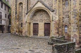
Abbatiale Sainte-Foy de Conques, Conques-en-Rouergue, Aveyron, France
Sainte-Foy Abbey, Conques
A Romanesque 11th- and 12th-century building with its cloister, stained glass, and treasury, it is the focal point of the village and a UNESCO-listed stop on the Compostela pilgrimage routes.
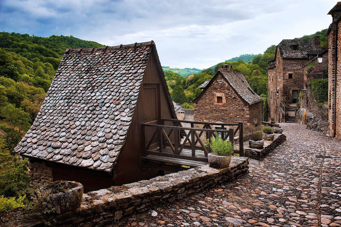
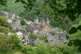
Conques, Conques-en-Rouergue, Aveyron, France
Conques
Tourist interest in the new municipality is centred on the old village of Conques. With its abbey church at its heart, the medieval village has grown with its characteristic half-timbered houses and slate roofs.
Frayssou House
Housed in a former wine cellar in the village of Conques, this small museum is dedicated to the traditional Conques habitat and its surroundings.
Joseph Fau Museum
The museum houses a collection of 16th-century furniture and 17th-century tapestries.

In the surrounding area

Climate and weather

Transportation

Getting there

Getting around

Accommodation

Dining

Useful addresses

Further reading

View guide page: Conques-en-Rouergue

Conques

Tourist interest in the new municipality is centred on the old village of Conques. With its abbey church at its heart, the medieval village has grown with its characteristic half-timbered houses and slate roofs.

Overview of Conques

Tourist interest in the new municipality is centred on the old village of Conques. With its abbey church at its heart, the medieval village has grown with its characteristic half-timbered houses and slate roofs.

Key Facts

  • Type of place: village.
  • Tourist interest: (recommended).
  • Location:
  • Distances:
  • Local time: Heure : 21946.
  • Population:
  • Area:
  • Altitude:

History of Conques

What to See and Do in Conques

In the Surrounding Area

Climate and Weather in Conques

Transport

Getting There

Getting Around

Accommodation

Eating Out

Useful Addresses

Further Information

View guide page: Conques

Sainte-Foy Abbey, Conques

A Romanesque 11th- and 12th-century building with its cloister, stained glass, and treasury, it is the focal point of the village and a UNESCO-listed stop on the Compostela pilgrimage routes.

Overview of the site

A Romanesque 11th- and 12th-century building with its cloister, stained glass, and treasury, it is the focal point of the village and a UNESCO-listed stop on the Compostela pilgrimage routes.

  • Tourist interest: (worth seeing).

History of Sainte-Foy Abbey

What to see and do

Practical information

  • Location:
  • Address: Place De L'Abbaye, 12320 Conques-en-Rouergue.
  • Opening hours:
  • Admission:
  • How to get there:

Nearby attractions

  1. == En complément
View guide page: Sainte-Foy Abbey, Conques

Joseph Fau Museum

The museum houses a collection of 16th-century furniture and 17th-century tapestries.

Overview of the Joseph Fau Museum

The museum houses a collection of 16th-century furniture and 17th-century tapestries.

  • Tourist interest: (worth a stop if you are in the area).

History of the Museum

Collections on Display

Practical Information

  • Location:
  • Address: Rue de l'Église, 12320 Conques.
  • Opening hours:
  • Admission fee:
  • How to get there:

Nearby Attractions

  1. == In addition
View guide page: Joseph Fau Museum

Frayssou House

Housed in a former wine cellar in the village of Conques, this small museum is dedicated to the traditional Conques habitat and its surroundings.

Overview of Frayssou House

Housed in a former wine cellar in the village of Conques, this small museum is dedicated to the traditional Conques habitat and its surroundings.

  • Tourist interest: (worth a stop if you are in the area).

Museum history

Collections on display

Practical information

  • Location:
  • Address: Cambelong, 12320 Conques.
  • Opening hours:
  • Price:
  • Website:
  • How to get there:

What to see nearby

  1. == In addition
View guide page: Frayssou House

Decazeville

This is the town of coal mines. Although they are all now closed, you can still visit a former open-cast mine here.

Overview of Decazeville

This is the town of coal mines. Although they are all now closed, you can still visit a former open-cast mine here.

Key facts

  • Type of place: small town.
  • Tourist interest: (worth a stop if you are in the area).
  • Location:
  • Distances:
  • Local time: Heure : 18292.
  • Population: 5,686 inhabitants (2014).
  • Area: 13.88 km².
  • Altitude: from 163 to 454 m.

History of Decazeville

What to see and do in Decazeville

In the surrounding area

Climate and weather in Decazeville

Transport

Getting there

Getting around

Accommodation

Eating out

Useful addresses

Further information

View guide page: Decazeville

Estaing

On the banks of the Lot River, the commune is known for its 15th-century château.

Overview of Estaing

On the banks of the Lot River, the commune of Estaing is known for its 15th-century château.

Key Facts

  • Type of place: village.
  • Tourist interest: (worth a stop if you are in the area).
  • Location: in the Aveyron department, north of Rodez.
  • Distances:
  • Local time: Heure : 18293.
  • Population: 547 inhabitants (2014).
  • Area: 17 km².
  • Altitude: from 301 to 760 m.

History of Estaing

What to See and Do in Estaing

The village of Estaing centers around its 12th-century château (and its beautiful Saint-Fleuret church), with schist houses and lauze roofs, along with a few fine private mansions.

In the Surrounding Area

Climate and Weather in Estaing

Transportation

Getting There

Getting Around

Accommodation

Dining

Useful Addresses

Further Information

View guide page: Estaing

La Cavalerie

The commune is one of the "Templar Cities" of the Larzac, alongside La Couvertoirade, which remains the best known.

Overview of La Cavalerie

The commune of La Cavalerie is one of the "Templar Cities" of the Larzac, alongside La Couvertoirade, which remains the best known.

Key Facts

  • Type of place: village.
  • Tourist interest: (worth a stop if you are in the area).
  • Location: in the Aveyron department, on the Larzac plateau.
  • Distances:
  • Local time: Heure : 18294.
  • Population: 1,070 inhabitants (2014).
  • Area: 40.56 km².
  • Altitude: from 764 to 892 m.

History of La Cavalerie

What to See and Do

As in the other Templar cities of the region, the village features restored ramparts, 15th-century houses, and 17th-century townhouses.

In the Surrounding Area

Climate and Weather

Transportation

Getting There

Getting Around

Accommodation

Dining

Useful Addresses

Further Information

View guide page: La Cavalerie

La Couvertoirade

This small village in the Larzac region is home to a beautiful 13th-century Knights Templar commandery.

Overview of La Couvertoirade

The small village of La Couvertoirade, in the Larzac region, is home to a beautiful Knights Templar commandery dating from the 13th century.

Key Facts

  • Type of place: village.
  • Tourist interest: (worth seeing).
  • Location: in the Aveyron department, on the Larzac plateau.
  • Distances:
  • Local time: Heure : 18295.
  • Population: 182 inhabitants (2014).
  • Area: 62 km².
  • Altitude: from 640 to 900 m.

History of La Couvertoirade

What to See and Do

Within its ramparts, the village is home to one of the region’s main Templar commanderies (13th century), as well as several religious buildings and fine 16th- and 17th-century residences.

In the Surrounding Area

Climate and Weather

Transport

Getting There

Getting Around

Accommodation

Food

Useful Addresses

Further Information

View guide page: La Couvertoirade

Laguiole

Famous for its knives and cheese, Laguiole is also a winter sports resort for both downhill and cross-country skiing.

Overview of Laguiole

Famous for its knives and cheese, Laguiole is also a winter sports resort for both downhill and cross-country skiing.

Key facts

  • Type de lieu: village.
  • Intérêt touristique: (worth a stop if you are in the area).
  • Localisation:
  • Distances:
  • Heure locale: Heure : 18296.
  • Population: 1,239 inhabitants (2014).
  • Superficie: 63.06 km².
  • Altitude: from 868 to 1,342 m.

History of Laguiole

What to see and do in Laguiole

In the surrounding area

Climate and weather in Laguiole

Transport

Getting there

Getting around

Accommodation

Eating

Useful addresses

Further information

View guide page: Laguiole

Millau

A sub-prefecture in Aveyron located at the heart of the Grandes Causses park, the town is primarily a possible base for exploring the surrounding area.

Overview of Millau

A sub-prefecture in Aveyron located at the heart of the Grandes Causses park, the town is primarily a possible base for exploring the surrounding area.

Key facts

  • Type of place: small town.
  • Tourist interest: (worth a stop if you are in the area).
  • Location:
  • Distances:
  • Local time: Heure : 18297.
  • Population: 22,064 inhabitants (2014).
  • Area: 168 km².
  • Altitude: from 340 to 888 m.

History of Millau

What to see and do in Millau

In the surrounding area

Climate and weather in Millau

Transport

Getting there

Getting around

Accommodation

Eating

Useful addresses

Further information

View guide page: Millau

Peyre

This troglodytic village (a hamlet of the Comprégnac commune) is listed among the "Most Beautiful Villages of France". From its outskirts, you get a beautiful panorama of the Millau Viaduct.

Overview of Peyre

This troglodytic village (a hamlet of the Comprégnac commune) is listed among the "Most Beautiful Villages of France". From the outskirts of Peyre, you also get a beautiful panorama of the Millau Viaduct.

Key Details

  • Type of place: village.
  • Tourist interest: (worth seeing).
  • Location: in the Aveyron department, next to Millau and its viaduct.
  • Distances: Albi ( km), Millau (7 km), Rodez ( km).
  • Local time: Heure : 18298.
  • Population:
  • Area:
  • Altitude:

History of Peyre

What to See and Do in Peyre

Narrow cobbled stairways lead to houses carved into the cliffside of the village. The hamlet also features a semi-troglodytic church and offers a stunning view of the Millau Viaduct.

Truffle House of Comprégnac
In the village to which Peyre belongs, the site offers insight into truffle culture and harvesting.

In the Surrounding Area

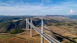
Viaduc de Millau, Aveyron, France
Millau Viaduct
Opened in 2004, it is the world's tallest road bridge and has also become, in a way, a major tourist attraction in the region.

Climate and Weather in Peyre

Transportation

Getting There

Getting Around

Accommodation

Dining

Useful Addresses

Further Information

View guide page: Peyre

Truffle House of Comprégnac

In the village to which Peyre belongs, the site offers insight into truffle culture and harvesting.

Overview of the Site

In the village to which Peyre belongs, the site offers insight into truffle culture and harvesting.

  • Tourist interest: (worth a stop if you are in the area).

History of the Museum

Collections and Activities

Practical Information

  • Location:
  • Address: Rue du Château, 12100 Comprégnac.
  • Opening hours:
  • Price:
  • How to get there:

Nearby Attractions

  1. == In addition
View guide page: Truffle House of Comprégnac

Rodez

The prefecture of Aveyron has some old quarters and a fortified cathedral.

Overview of Rodez

The prefecture of Aveyron has some old quarters and a fortified cathedral.

Key facts

  • Type of place: small town.
  • Tourist interest: (worth a stop if you are in the area).
  • Location:
  • Distances:
  • Local time: Heure : 18299.
  • Population: 24,088 inhabitants (2014).
  • Area: 11.18 km².
  • Altitude: from 500 to 640 m.

History of Rodez

What to see and do in Rodez

In the surrounding area

Climate and weather in Rodez

Transport

Getting there

Getting around

Accommodation

Eating

Useful addresses

Further information

View guide page: Rodez

Roquefort

This small commune is world-famous for its cheese. You can also visit several aging cellars here.

Overview of Roquefort

This small commune, officially called Roquefort-sur-Soulzon, is world-famous for its cheese. You can also visit several aging cellars here.

Key Facts

  • Type of place: village.
  • Tourist interest: (worth a stop if you are in the area).
  • Location: in the Aveyron department, not far from Millau.
  • Distances:
  • Local time: Heure : 18300.
  • Population: 613 inhabitants (2014).
  • Area: 17 km².
  • Altitude: from 424 to 828 m.

History of Roquefort

What to See and Do in Roquefort

Roquefort Caves
Like wine cellars elsewhere, these (natural) caves let you discover and taste the town’s specialty product.

In the Surrounding Area

Climate and Weather

Transportation

Getting There

Getting Around

Accommodation

Eating Out

Useful Addresses

Further Information

View guide page: Roquefort

Roquefort Caves

Like wine cellars elsewhere, these (natural) caves let you discover and taste the town’s specialty product.

Overview of the Roquefort Caves

Like wine cellars elsewhere, these (natural) caves let you discover and taste the town’s specialty product.

  • Tourist interest: (worth a stop if you are in the area).

History of the Roquefort Caves

Activities and Events

Practical Information

  • Location:
  • Address: 2 avenue François Galtier, 12250 Roquefort-sur-Soulzon.
  • Opening hours:
  • Rates:
  • How to get there:

Nearby

View guide page: Roquefort Caves

Saint-Amans-des-Côts

It’s a charming village on the foothills of the Aubrac.

Overview of Saint-Amans-des-Côts

It’s a charming village on the foothills of the Aubrac.

Key facts

  • Tourist interest: (worth a stop if you are in the area).
  • Location:
  • Distances:
  • Local time: Heure : 18301.
  • Population: 754 inhabitants (2014).
  • Area: 41.51 km².
  • Altitude: from 355 to 882 m.

History of Saint-Amans-des-Côts

What to see and do

In the surrounding area

Climate and weather

Transport

Getting there

Getting around

Accommodation

Food

Useful addresses

Further information

View guide page: Saint-Amans-des-Côts

Saint-Côme-d'Olt

It is one of the ten communes in the department designated as one of the "Most Beautiful Villages of France."

Overview of Saint-Côme-d'Olt

Saint-Côme-d'Olt is one of the ten communes in the Aveyron department designated as one of the "Most Beautiful Villages of France."

Key Details

  • Type of place: village.
  • Tourist interest: (worth a stop if you are in the area).
  • Location: in Aveyron, north of Rodez.
  • Distances:
  • Local time: Heure : 18302.
  • Population: 1,338 inhabitants (2014).
  • Area: 30.1 km².
  • Altitude: from 340 to 840 m.

History of Saint-Côme-d'Olt

What to See and Do

With its almost circular layout, the village center—featuring fortified gates, an old manor, historic houses, narrow streets, its church, and chapel—is typical of medieval architecture.

In the Surrounding Area

Climate and Weather

Transportation

Getting There

Getting Around

Accommodation

Dining

Useful Addresses

Further Information

View guide page: Saint-Côme-d'Olt

Saint-Jean d'Alcas

One of the five medieval towns of the Larzac region dating back to the era of the Knights Templar.

Overview of Saint-Jean d'Alcas

Saint-Jean d'Alcas is one of two hamlets that make up the commune of Saint-Jean-et-Saint-Paul. It is also one of the five medieval towns of the Larzac region dating back to the era of the Knights Templar.

Key Details

  • Type of place: village.
  • Tourist interest: (worth a stop if you are in the area).
  • Location: in Aveyron, on the Causses du Larzac.
  • Distances:
  • Local time: Heure : 18303.
  • Population: 271 inhabitants (2014).
  • Area: 37.9 km².
  • Altitude: from 432 to 825 m.
  • Website:

History of Saint-Jean d'Alcas

What to see and do in Saint-Jean d'Alcas

The town originated as a fortified Templar village that has retained its ramparts. Inside, you can explore two small streets, a chapel, and houses built from local stone.

In the surrounding area

Climate and weather

Transportation

Getting there

Getting around

Accommodation

Dining

Useful addresses

Additional information

View guide page: Saint-Jean d'Alcas

Sainte-Eulalie-de-Cernon

A small medieval village in the Larzac region, home to the best-preserved Templar commandery in France.

Overview of Sainte-Eulalie-de-Cernon

Sainte-Eulalie-de-Cernon is a small medieval village in the Larzac region with a Templar commandery that is the best-preserved in France.

Key details

  • Type of place: village.
  • Tourist interest: (worth seeing).
  • Location: in the Aveyron department, on the Larzac.
  • Distances:
  • Local time: Heure : 18304.
  • Population: 272 inhabitants (2014).
  • Area: 46.35 km²
  • Altitude: from 529 m to 912 m.

History of Sainte-Eulalie-de-Cernon

What to see and do

Like many others in the region, the village has retained its medieval character with its church, commandery, old houses, and remnants of ramparts and defensive towers.

Commandery of Sainte-Eulalie-de-Cernon
This is the best-preserved Templar commandery (monastic fortress) in France. It dates back over seven centuries.

In the surrounding area

Climate and weather

Transport

Getting there

Getting around

Accommodation

Food

Useful addresses

Further information

View guide page: Sainte-Eulalie-de-Cernon

Commandery of Sainte-Eulalie-de-Cernon

This is the best-preserved Templar commandery (monastic fortress) in France. It dates back over seven centuries.

Overview of the site

This is the best-preserved Templar commandery in France. It dates back over seven centuries.

  • Tourist interest: (worth seeing).

History of the commandery

What to see and do

Practical information

  • Location:
  • Local time: Heure : 21967.
  • Address: Place de l'Église, 12230 Sainte-Eulalie-de-Cernon.
  • Opening hours:
  • Admission fee:

Transport

Accommodation and dining

Nearby attractions

  1. == En complément
View guide page: Commandery of Sainte-Eulalie-de-Cernon

Sainte-Eulalie-d'Olt

This spot is one of the "most beautiful villages of France" in Aveyron, nestled along the Lot River.

Overview of Sainte-Eulalie-d'Olt

This spot is one of the "most beautiful villages of France" in Aveyron, nestled along the Lot River.

Key details

  • Type de lieu: village.
  • Intérêt touristique: (worth seeing).
  • Localisation: in the Aveyron department, north of Rodez.
  • Distances:
  • Heure locale: Heure : 18305.
  • Population: 375 inhabitants (2014).
  • Superficie: 17.48 km².
  • Altitude: from 440 to 876 m.

History of Sainte-Eulalie-d'Olt

What to see and do

The village along the Lot River is laid out in a semicircle around the church square, with its cobbled streets and beautiful, often flower-decked, 15th-century houses.

Mills of Sainte-Eulalie-d'Olt
Eight small water mills can be seen in the area around the village. They bear witness to the former tannery, cloth-making, and spinning activities in the commune.
Marcel Boudou Museum-Gallery
Works by a local painter and temporary photography exhibitions.

In the surrounding area

Climate and weather

Getting around

Getting there

Getting around

Where to stay

Where to eat

Useful addresses

Further reading

View guide page: Sainte-Eulalie-d'Olt

Marcel Boudou Museum-Gallery

Works by a local painter and temporary photography exhibitions.

Overview of the Marcel Boudou Museum

Works by a local painter and temporary photography exhibitions.

  • Tourist interest: (worth a stop if you are in the area).

History of the Museum

Collections on Display

Practical Information

  • Location:
  • Address: 12130 Sainte-Eulalie-d'Olt.
  • Opening hours:
  • Price:
  • How to get there:

Nearby Attractions

  1. == In addition
View guide page: Marcel Boudou Museum-Gallery

Mills of Sainte-Eulalie-d'Olt

Eight small water mills can be seen in the area around the village. They bear witness to the former tannery, cloth-making, and spinning activities in the commune.

Overview of the mills

Eight small water mills can be seen in the area around the village. They bear witness to the former tannery, cloth-making, and spinning activities in the commune.

  • Tourist interest: (worth a stop if you are in the area).

History of the mills of Sainte-Eulalie

What to see and do

Practical information

  • Location:
  • Local time: Heure : 21962.
  • Address: 12130 Sainte-Eulalie-d'Olt.
  • Opening hours:
  • Price:

Transport

Accommodation and dining

What to see nearby

  1. == En complément
View guide page: Mills of Sainte-Eulalie-d'Olt

Sauveterre-de-Rouergue

A beautifully preserved former bastide near Rodez, labeled one of "France’s Most Beautiful Villages."

Overview of Sauveterre-de-Rouergue

Sauveterre-de-Rouergue is a beautifully preserved former bastide located near Rodez and labeled one of "France’s Most Beautiful Villages."

Key details

  • Type de lieu: village.
  • Intérêt touristique: (worth seeing).
  • Localisation: in Aveyron, between Albi and Rodez.
  • Distances: Albi ( km), Millau ( km), Rodez (35 km), Villefranche-de-Rouergue ( km).
  • Heure locale: Heure : 18306.
  • Population: 797 inhabitants (2014).
  • Superficie: 23.43 km².
  • Altitude: from 333 to 682 m.

History of Sauveterre-de-Rouergue

What to see and do

The bastide is superbly preserved, featuring a magnificent central square with arcades, beautiful half-timbered and Renaissance-style houses, and the 14th-century collegiate church of Saint-Christophe.

In the surrounding area

Climate and weather

Getting around

How to get there

Getting around

Where to stay

Where to eat

Useful addresses

Further reading

View guide page: Sauveterre-de-Rouergue

Millau Viaduct

Opened in 2004, it is the world's tallest road bridge and has also become, in a way, a major tourist attraction in the region.

Overview of the viaduct

Opened in 2004, it is the world's tallest road bridge and has also become, in a way, a major tourist attraction in the region.

  • Tourist interest: (worth seeing).

History of the viaduct

What to see and do

Practical information

  • Location:
  • Address: Millau Viaduct, 12400 Millau.
  • Opening hours:
  • Price:
  • How to get there:

What to see nearby

Additional information

View guide page: Millau Viaduct

Villefranche-de-Rouergue

The sub-prefecture of Aveyron has a rather pretty town centre and a fine collegiate church.

Overview of the town

The sub-prefecture of Aveyron has a rather pretty town centre and a fine collegiate church.

Key facts

  • Type of place: small town.
  • Tourist interest: (worth seeing).
  • Location:
  • Distances:
  • Local time: Heure : 18309.
  • Population: 11,822 inhabitants (2014).
  • Area: 45.85 km².
  • Altitude: from 237 to 544 m.

History of Villefranche-de-Rouergue

What to see and do

In the surrounding area

Climate and weather

Transport

Getting there

Getting around

Accommodation

Food and drink

Useful addresses

Further information

View guide page: Villefranche-de-Rouergue

Roquelaure Lava Flow

Located in the Lot Valley, this is a geological curiosity linked to the surrounding volcanoes.

Overview of the site

Located in the Lot Valley, this is a geological curiosity linked to the surrounding volcanoes.

Key details

  • Tourist interest: (worth a stop if you are in the area).
  • Features: scree of basaltic rock blocks.
  • Location:
  • Area:
  • Altitude: from 500 to 800 m.
  • Website:

Site environment

Wildlife and flora

What to see and do

In the surrounding area

Climate and weather

Precautions

Getting there

Sleeping and eating

  1. == En complément
View guide page: Roquelaure Lava Flow

Aveyron Gorges

Pretty gorges that follow the course of the river of the same name for about 250 km.

Overview of the gorges

These are pretty gorges that follow the course of the river of the same name for about 250 kilometres.

  • Tourist interest: (worth seeing).
  • Features:
  • Length: About 250 km.
  • Depth:
  • Altitude:

Environment

Wildlife and flora

Precautions

Climate and weather

What to see and do

Practical information

  • Location:
  • How to get there:
  • Distances:

Sleeping and eating

What to see nearby

Further information

View guide page: Aveyron Gorges

Lake Pareloup

This artificial lake (one of the largest in France), between Millau and Rodez, is popular with visitors for swimming, fishing, or boat trips.

Overview of the lake

This artificial lake (one of the largest in France), between Millau and Rodez, is popular with visitors for swimming, fishing, or boat trips.

  • Tourist interest: (worth a stop if you are in the area).
  • Features: artificial lake.
  • Surface area: 12.6 km².
  • Altitude: 805 m.

Environment

Precautions

What to see and do

In the surrounding area

Climate and weather

Practical information

  • Location:
  • Website:
  • How to get there:
  • Distances:

Accommodation and dining

  1. == For further information
View guide page: Lake Pareloup

Larzac

A stunning limestone plateau in the Causses region, located in Aveyron (and partly in Hérault). You can visit the "Templar Cities" of Larzac (La Cavalerie, La Couvertoirade) or go hiking there.

Overview of Larzac

A stunning limestone plateau in the Causses region, located in Aveyron (and partly in Hérault), between Millau and Lodève. You can visit the "Templar Cities" of Larzac (La Cavalerie, La Couvertoirade) or go hiking there.

Key details

  • Type of place: plateau or plain.
  • Tourist interest: (recommended).
  • Features:
  • Location:
  • Local time: Heure : 18314
  • Population:
  • Area: around 1,000 km².
  • Altitude: from 600 to 900 m.

Environment

Wildlife and flora

Precautions

What to see and do

Nearby

Climate and weather in Larzac

Transport

Getting there

Getting around

Accommodation

Food

Additional information

View guide page: Larzac

Montpellier-le-Vieux

An impressive rocky chaos located in La Roque-Sainte-Marguerite, not far from Millau. It's a climbing site.

Overview of Montpellier-le-Vieux

This is an impressive rocky chaos located in La Roque-Sainte-Marguerite, not far from Millau. It's a climbing site.

  • Tourist interest: (worth seeing).
  • Features: rocky chaos.
  • Location:
  • Area: 1.20 km².
  • Altitude:

Environment

Wildlife and flora

Precautions

What to see and do

In the surrounding area

Climate and weather

Getting there

Sleeping and eating

  1. == Further information
View guide page: Montpellier-le-Vieux

Bozouls Hole

This is a vast limestone cirque forming a meander of the Dourdou River, which has made the small town of Bozouls famous in the northern part of the department.

Overview of the site

This is a vast limestone cirque forming a meander of the Dourdou River, which has made the small town of Bozouls famous in the northern part of the department.

  • Tourist interest: (worth seeing).
  • Features: limestone cirque.
  • Length:
  • Depth: 100 m.
  • Altitude: 500 m

Environment

Wildlife and flora

Precautions

Climate and weather

What to see and do

Practical information

  • Location:
  • How to get there:
  • Distances:

Getting around

Accommodation and dining

What to see nearby

  1. == En complément
View guide page: Bozouls Hole

Najac

The medieval village and its towering hilltop castle overlook the gorges of the Aveyron. It is one of the "most beautiful villages in France".

Overview of Najac

The medieval village of Najac and its towering hilltop castle overlook the Aveyron Gorges. It is one of the "most beautiful villages in France".

Key details

  • Type de lieu: village.
  • Intérêt touristique: (worth seeing).
  • Distances:
  • Heure locale: Heure : 21954.
  • Population: 711 inhabitants (2014).
  • Superficie: 53.9 km²
  • Altitude: from 158 to 507 m.

History of Najac

What to see and do in Najac

As is often the case in the region, beautiful medieval houses, narrow streets, a lovely church, and a small bridge over the Aveyron make up the village’s charm.

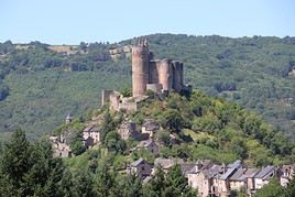
Forteresse royale de Najac, Najac, Aveyron, France
Royal Fortress of Najac
Perched dramatically on its rock, it overlooks the entire village and the surrounding gorges. It dates back to the 13th century.

In the surrounding area

Aveyron Gorges
Pretty gorges that follow the course of the river of the same name for about 250 km.

Climate and weather in Najac

Transport

Getting there

Getting around

Where to stay

Where to eat

Useful addresses

Further information

View guide page: Najac

Royal Fortress of Najac

Perched dramatically on its rock, it overlooks the entire village and the surrounding gorges. It dates back to the 13th century.

Overview of the Fortress

Perched dramatically on its rock, it overlooks the entire village and the surrounding gorges. It dates back to the 13th century.

  • Tourist interest: (worth seeing).

History of the Royal Fortress of Najac

What to See and Do

Practical Information

  • Location:
  • Local time: Heure : 21956.
  • Address: Rue du Château, 12270 Najac.
  • Opening hours:
  • Price:

Transport

Sleeping and Eating

Nearby Attractions

  1. == En complément
View guide page: Royal Fortress of Najac

Séverac d'Aveyron

It is a charming medieval town dominated by a 13th-century fortress.

Overview of Séverac d'Aveyron

In 2016, the municipality of Sévérac-le-Château merged with four neighboring communes to form the new municipality of Séverac d'Aveyron. It is a charming medieval town dominated by a 13th-century fortress.

Key Facts

  • Type de lieu: small town.
  • Intérêt touristique: (worth seeing).
  • Localisation: in the Aveyron department, north of Millau.
  • Distances:
  • Heure locale: Heure : 21969.
  • Population: 4,134 inhabitants (2014).
  • Superficie: 208.7 km².
  • Altitude: from 454 m to 1,129 m.

History of Séverac d'Aveyron

What to See and Do in Séverac d'Aveyron

Lake Cisba
A small body of water in the municipality, set up for fishing or swimming.
Archaeological Museum of Sévérac-le-Château
Everyday objects from the 16th century to 300,000 years ago, unearthed in the Upper Aveyron Valley.
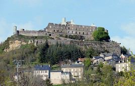
Séverac le Château, Séverac d'Aveyron, Aveyron, France
Séverac le Château
The tourist appeal of the new municipality is concentrated in the former Séverac-le-Château, with its 13th-century hilltop castle overlooking a medieval village of beautiful period houses.

In the Surrounding Area

Climate and Weather

Transportation

Getting There

Getting Around

Accommodation

Dining

Useful Addresses

Further Information

View guide page: Séverac d'Aveyron

Séverac le Château

The tourist appeal of the new municipality is concentrated in the former Séverac-le-Château, with its 13th-century hilltop castle overlooking a medieval village of beautiful period houses.

Overview of Séverac le Château

The tourist appeal of the new municipality is concentrated in the former Séverac-le-Château, with its 13th-century hilltop castle overlooking a medieval village of beautiful period houses.

Key Facts

  • Type of place: village.
  • Tourist interest: (worth seeing).
  • Location:
  • Distances:
  • Local time: Heure : 18307.
  • Population:
  • Area:
  • Altitude:

History of Séverac le Château

What to See and Do in Séverac le Château

In the Surrounding Area

Climate and Weather

Transportation

Getting There

Getting Around

Accommodation

Dining

Useful Addresses

  1. == Additional Information
View guide page: Séverac le Château

Lake Cisba

A small body of water in the municipality, set up for fishing or swimming.

Overview of Lake Cisba

A small body of water in the municipality of Séverac, set up for fishing or swimming.

Key details

  • Type of place: lake.
  • Tourist interest: (worth a stop if you are in the area).
  • Features:
  • Surface area:
  • Altitude:

Lake environment

Wildlife and flora

Climate and weather

Precautions

What to see and do

Practical information

  • Location:
  • Distances:

Getting there

Accommodation and dining

Nearby attractions

  1. == En complément
View guide page: Lake Cisba

Archaeological Museum of Sévérac-le-Château

Everyday objects from the 16th century to 300,000 years ago, unearthed in the Upper Aveyron Valley.

Overview of the Museum

The museum displays everyday objects from the 16th century to 300,000 years ago, unearthed in the Upper Aveyron Valley.

  • Tourist interest: (worth a stop if you are in the area).

History of the Archaeological Museum

Collections on Display

Practical Information

  • Location:
  • Address: 11bis rue Amaury de Sévérac, 12150 Sévérac-le-Château.
  • Opening hours:
  • Admission fee:
  • How to get there:

Nearby Attractions

  1. == As a supplement
View guide page: Archaeological Museum of Sévérac-le-Château

Something wrong or out of date? Report this page