Skip to content
What to See in Mauricie

Travel guide

What to See in Mauricie

last edited Dec 11, 2019

Downtown Trois-Rivières, the Cité de l'énergie, Les Forges-du-Saint-Maurice, the Musée québécois de culture populaire, Mauricie National Park, Saint-Élie-de-Caxton, and the Sanctuaire Notre-Dame-du-Cap.

Cities and Cultural Heritage

Saint-Élie-de-Caxton
This village was made famous by Quebec storyteller Fred Pellerin. Audio-guided tours or horse-drawn carriage rides are available to explore the area.
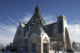
Basilique, Sanctuaire Notre-Dame-du-Cap, Québec, Canada
Notre-Dame-du-Cap Shrine
This shrine in Cap-de-la-Madeleine, along the St. Lawrence River, includes a large basilica, an old sanctuary, and beautiful gardens.
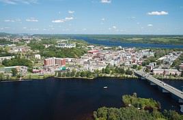
Shawinigan, Québec, Canada
Shawinigan
This city is located on the banks of the Saint-Maurice River. It is home to the La Cité de l'Énergie museum complex. Mauricie National Park is also nearby.
Saint-Tite
This large village of 4,000 residents is famous for its Western festival, which draws over 700,000 visitors each year.
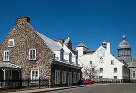
Trois-Rivières, Trois-Rivières, Québec, Canada
Trois-Rivières
Located on the banks of the St. Lawrence River, Trois-Rivières is the second-oldest city in Quebec, founded in 1634. Its downtown is a lively district packed with historic sites, museums, shops, cafés, and restaurants.

Natural Heritage
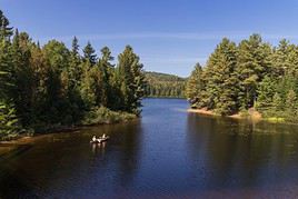
Parc national de la Mauricie, Québec, Canada
La Mauricie National Park
536 km² of nature and a variety of year-round activities, including camping, hiking, cycling, kayaking, canoeing, cross-country skiing, snowshoeing, and more.

Worth a look / Other

★★

La Mauricie National Park

536 km² of nature and a variety of year-round activities, including camping, hiking, cycling, kayaking, canoeing, cross-country skiing…
★★

Notre-Dame-du-Cap Shrine

This shrine in Cap-de-la-Madeleine, along the St. Lawrence River, includes a large basilica, an old sanctuary, and beautiful gardens.
★★

Trois-Rivières (Quebec)

Located on the banks of the St. Lawrence River, Trois-Rivières is the second-oldest city in Quebec, founded in 1634. Its downtown is a…
★

Saint-Élie-de-Caxton

This village was made famous by Quebec storyteller Fred Pellerin. Audio-guided tours or horse-drawn carriage rides are available to explore…
★

Saint-Tite

This large village of 4,000 residents is famous for its Western festival, which draws over 700,000 visitors each year.
★

Shawinigan

This city is located on the banks of the Saint-Maurice River. It is home to the La Cité de l'Énergie museum complex. Mauricie National Park…

Saint-Élie-de-Caxton

This village was made famous by Quebec storyteller Fred Pellerin. Audio-guided tours or horse-drawn carriage rides are available to explore the area.

Introduction to Saint-Élie-de-Caxton

This village was made famous by Quebec storyteller Fred Pellerin. Audio-guided tours or horse-drawn carriage rides are available to explore the area.

Key Details

  • Type of place: village.
  • Tourist interest: (worth a stop if you are in the area).
  • Location:
  • Distances:
  • Local time: Heure : 8699.
  • Population: 1,836 inhabitants (2016).
  • Area: 116.70 km².
  • Altitude:

History of Saint-Élie-de-Caxton

What to See and Do in Saint-Élie-de-Caxton

Nearby

Climate and Weather

Transportation

Getting There

Getting Around

Accommodation

Dining

Useful Addresses

  1. == Additional Information
View guide page: Saint-Élie-de-Caxton

Saint-Tite

This large village of 4,000 residents is famous for its Western festival, which draws over 700,000 visitors each year.

Overview of Saint-Tite

This large village of 4,000 residents is famous for its Western festival, which draws over 700,000 visitors each year.

Key Facts

  • Type of place: small town.
  • Tourist interest: (worth a stop if you are in the area).
  • Location:
  • Distances:
  • Local time: Heure : 8715.
  • Population: 3,673 residents (2016).
  • Area: 91.55 km².
  • Elevation: from 110 m to 309 m.

History of Saint-Tite

Things to See and Do in Saint-Tite

In the Surrounding Area

Climate and Weather in Saint-Tite

Transportation

Getting There

Getting Around

Accommodation

Dining

Useful Addresses

Additional Information

View guide page: Saint-Tite

Shawinigan

This city is located on the banks of the Saint-Maurice River. It is home to the La Cité de l'Énergie museum complex. Mauricie National Park is also nearby.

Overview of Shawinigan

This city is located on the banks of the Saint-Maurice River. It is home to the La Cité de l'Énergie museum complex. The La Mauricie National Park is also nearby.

Key Details

  • Type of place: small town.
  • Tourist interest: (worth a stop if you are in the area).
  • Location:
  • Distances:
  • Local time: Heure : 8729.
  • Population: 49,349 inhabitants (2016).
  • Area: 737.12 km².
  • Altitude:

History of Shawinigan

What to See and Do in Shawinigan

In the Surrounding Area

Climate and Weather in Shawinigan

Transportation

Getting There

Getting Around

Accommodation

Dining

Useful Addresses

Additional Information

View guide page: Shawinigan

La Mauricie National Park

536 km² of nature and a variety of year-round activities, including camping, hiking, cycling, kayaking, canoeing, cross-country skiing, snowshoeing, and more.

Overview of La Mauricie National Park

This park offers 536 km² of nature and a variety of year-round activities, including camping, hiking, cycling, kayaking, canoeing, cross-country skiing, snowshoeing, and more.

Key Details

  • Type of place: national park.
  • Tourist interest: (worth seeing).
  • Features:
  • Area: 536.7 km².
  • Altitude:

Environment

Landscape of the Park

Wildlife and Flora

Precautions

Climate and Weather

What to See and Do

Nearby Attractions

Practical Information

  • Location:
  • Distances:
  • Opening period:
  • Rates:

Transportation

Getting There

Getting Around

Accommodation

Food

Additional Resources

View guide page: La Mauricie National Park

Notre-Dame-du-Cap Shrine

This shrine in Cap-de-la-Madeleine, along the St. Lawrence River, includes a large basilica, an old sanctuary, and beautiful gardens.

Overview of Notre-Dame-du-Cap Shrine

This shrine in Cap-de-la-Madeleine, along the St. Lawrence River, includes a large basilica, an old sanctuary, and beautiful gardens.

  • Tourist interest: (worth seeing).

History of the Basilica

What to See and Do

Practical Information

  • Location:
  • Address: 626 Notre-Dame E Street, Trois-Rivières, QC G8T 4G9.
  • Opening hours:
  • Admission:
  • How to get there:

Nearby Attractions

  1. == In addition
View guide page: Notre-Dame-du-Cap Shrine

Trois-Rivières (Quebec)

Located on the banks of the St. Lawrence River, Trois-Rivières is the second-oldest city in Quebec, founded in 1634. Its downtown is a lively district packed with historic sites, museums, shops, cafés, and restaurants. Overview of Trois-Rivières Climate and Weather in Trois-Rivières What to See in Trois-Rivières What to Do in Trois-Rivières Getting to Trois-Rivières Getting Around Trois-Rivières Accommodation and Dining in Trois-Rivières Living in Trois-Rivières

Further Information

View guide page: Trois-Rivières (Quebec)

Overview of Trois-Rivières (Quebec)

Overview of Trois-Rivières

Located on the banks of the St. Lawrence River, Trois-Rivières is the second oldest settlement in Quebec, founded in 1634. Its downtown is a lively district packed with historic sites, museums, shops, cafés, and restaurants.

Key Facts

  • Type of place: city.
  • Tourist interest: (worth seeing).
  • Location:
  • Distances:
  • Local time: Heure : 11078.
  • Population: 134,413 inhabitants (2016).
  • Area: 289.32 km².
  • Elevation: from 0 to 75 m.

History of Trois-Rivières

Precautions

Useful Addresses

  • Tourist Office:

Services

  • Local agencies:
  • Banks:
  • Hospital:
  • Internet:
  • Laundries:
  • Vehicle rental:
  • Post office:
View guide page: Overview of Trois-Rivières (Quebec)

Climate and Weather in Trois-Rivières (Quebec)

Climate Overview

Best Climate Period for Trois-Rivières (Quebec)

Jan.Feb.Mar.Apr.MayJun.Jul.Aug.Sep.Oct.Nov.Dec.
Climate

Climate and Forecast

Additional Information

View guide page: Climate and Weather in Trois-Rivières (Quebec)

Something wrong or out of date? Report this page