Hi everyone,
I’d love to hear your thoughts and experiences about marrying a Cuban and moving to Cuba (not the other way around!). Yes, some of us actually *want* to stay on the island! Is it possible to work there without too much hassle, or is it really complicated?
Thanks in advance!
21 similar discussions in English
Hello,
This is still just a plan: My wife and I are considering a bike trip in Denmark.
The timeframe would be July 2020, for a solid three weeks. We’d prefer to do a loop to avoid seeing the same landscapes and cities. We also camp.
We have our own well-equipped bikes and a single-wheel "Bob" trailer.
We’ll likely start and finish in Copenhagen, covering 40 to 60 km per day while leaving time to explore the cities and regions.
Through word of mouth, we know Denmark is another cycling country, so we won’t have any trouble finding bike paths.
However, when it comes to documents, we’re a bit lost. Since we don’t know the country at all, we’re not sure what’s most interesting to see and travel through.
We have the double-sided *Dänemark* map at 1:150,000 from Freytag & Berndt. It shows bike routes and campgrounds (which is great!), but it’s not very practical for biking.
Our experience in the Netherlands with "road" maps that quickly fell apart in the rain showed us the limits of those documents...
Are there more practical resources? Like a bike guide similar to what we have in France or for European bike routes?
Is there a system for identifying bike route numbers like in Holland?
And of course, we’d love any practical tips—cost of living, campground prices, hospitality (which I’m sure is excellent), weather quirks, coastal areas, wind (memories of the Netherlands!!!), and, of course, your personal favorites...
Thanks in advance to all contributors;
Pierre and Dominique from Lorient
Why bike (MTB) along the canal between the Two Seas: the lateral canal of the Garonne from Bordeaux to Toulouse, and the Midi Canal from Toulouse to the Mediterranean?
This canal was created to connect the Mediterranean to the Atlantic without going around Spain, and along its entire length, there’s an old towpath (used to pull barges). Since this path is closed to traffic (except for service vehicles from Voies Navigables de France), no cars drive on it—it’s dangerous, noisy, and polluting. The Canal between the Two Seas was built for transporting goods, so it passes through many towns you can explore without dealing with traffic. You can stock up on supplies or spend the night. You’ll discover the varied landscapes of the countryside, always in the serenity brought by the calm and slow flow of the canal’s water. Most of the time, you’ll be in the shade of trees planted to stabilize the banks with their roots. All you have to do is follow this blue—or rather green—ribbon without needing to consult a map. But the biggest advantage is that it’s flat! Of course, on the Canal du Midi, water flows from the watershed divide at Naurouze eastward to the Mediterranean and westward to Toulouse. On the lateral canal of the Garonne, water flows toward Bordeaux. But this slope is almost imperceptible, which is a huge plus when you want to travel by bike for several days with luggage.
When I say "bike," I really mean MTB because, while the towpath has been replaced in some places by a paved bike path, it mostly resembles a dirt trail—sometimes smooth, sometimes rocky, and often cluttered with roots from the magnificent trees lining it. Since the canal was classified as a UNESCO World Heritage site, improvements have been underway, but it won’t be tomorrow that you’ll be able to ride from Bordeaux to Sète on a road bike. And I’m afraid the first sections of the path will be worn out before the rest is finished. You might even run into construction work for this bike path. That’s what happened to me during the spring of 2007.
Sunday, 03/11 – Valence d'Agen 08:15 to Toulouse (Rangueil) 16:30 97 km in 8h15 (6h on the bike) I started on the recently paved path along the lateral canal of the Garonne. The first locks appeared, and as I approached Moissac, the path turned into a billiard table until Castelsarrasin. After the Cousteau port, I was back on the classic dirt towpath with its rocks, roots, and nutria holes. But not for long—soon, I hit ruts left by backhoes and bulldozers, which, fortunately, were resting for the Sunday. A pile of rubble taller than me blocked the entire width of the path. I didn’t want to turn back to find the previous bridge and ride on the other bank, which was just as impassable (dense grass). It wasn’t easy to carry a bike with full panniers, so I lifted it over several mounds. I kept going, sometimes on foot, unsure how far the construction extended. Another bulldozer—luckily, the ground was dry. The work went all the way to Montech, making the path impassable. I recommend taking the N113, which runs parallel (that’s what I did on the way back). In Montech, the famous water slope was at rest, waiting for tourists. For many kilometers, I was back on the traditional towpath. The closer I got to Toulouse, the better the surface became, and the more cyclists and pedestrians I saw—until the city center, where there was nonstop bike traffic, especially students heading to Rangueil.
Monday, 03/12 – Rangueil 09:10 to Revel 16:30 86 km in 7h20 (5h30 on the bike) As soon as you reach Toulouse, you make a 90° turn to follow the connection between the lateral canal and the Canal du Midi. Heading east, you pass the barge selling the famous Toulouse violet souvenirs. A real bike path has been built for 50 km to Port Lauragais. It’s a true joy for Toulousains and travelers. Restrooms have been installed or shared with highway rest areas, allowing you to refill water (of course, bikes are banned from ASF rest areas, but cleverly placed racks let you secure your bike and walk in). At Port Lauragais, it’s another rest area shared by highway users, cyclists, and boaters. You’ll find a cafeteria, restaurant, hotel, and a shop selling regional souvenirs. But the real pleasure is reaching the watershed divide at Naurouze, where water flows toward the Mediterranean on one side and the Atlantic on the other. There, I decided to leave the Canal du Midi, which continues toward Castelnaudary with a much rougher towpath, to follow the *Rigole* that feeds the canal with water from the Saint-Ferréol basin. For me, it was like returning to the source—a bit like a pilgrimage in honor of the brilliant Pierre-Paul Riquet, the designer of this magnificent work. I followed the service trail along the *Rigole*. It’s actually a variant of the GR 653, leading to Revel alongside this artificial waterway. It’s fed by water from the Montagne Noire, and I was worried about a steep climb. But that wasn’t the case—the *Rigole* winds for 40 km, flowing gently under the trees. It was better than a dream: a smooth dirt path with the crunch of pine needles under the wheels, where I only crossed paths with a few fishermen... And to soothe sore buns, the last kilometers were on packed earth—a paradise (ATVs, stay away!). More walkers and cyclists appeared there.
Tuesday, 03/13 After a restful night in Revel, I started the morning with a walk around Lake Saint-Ferréol. A very pleasant 10 km hike, but I don’t recommend it for mountain bikers unless you’re used to mountain terrain and have strong calves. Otherwise, you can take the road—there are at least two hotels near the lake. In the afternoon, I began the return trip to Tarn-et-Garonne via the same path, with the same pleasure.
Total: 378 km of suffering and bliss, for which I must thank the departmental and regional councils for their funding, Voies Navigables de France for maintenance, and the volunteers who mark the hiking trails. And don’t you think you’re exaggerating a bit with your 378 km of bliss and the paradise of the *Rigole*?
Okay, fine—it wasn’t always idyllic. Sometimes the path was downright *pierrique*... but I had great weather, and the landscapes were so beautiful (water, sun, vegetation). In the rain or mud, it would’ve been less fun. What does *pierrique* even mean?
*Pierrique* is worse than rocky. I know a Pierrick, and he’s tough. And why *Facteur4*?
It’s France’s goal to reduce greenhouse gas emissions by a factor of 4 by 2050. I’m doing my part by biking to work 3 out of 4 times. And your cassoulet?
Guilty as charged. I ate the best cassoulet of my life at the Hôtel du Midi in Revel. But it was very productive in methane. My stomach hurt so much I couldn’t sleep and ended up writing my postcards between 3 and 4 AM. So many great memories!
Hi there,
While reading some travel journals, I notice that we always reflect on the people of the countries we visit.
I’d love to hear your thoughts on which people charmed you the most during your travels?
I’m not looking for controversy, just reflections and personal feelings. Looking forward to reading your replies...
Hello everyone,
We’re heading to South America in February 2020 for our first three-month trip and plan to return in 2021 for another three-month adventure. We’ll be shipping our Toyota with a fitted camper (Azalaï) in a container. We chose Wave Logistics for the transport based on the tips we read here on the forum.
At the end of this first trip, around mid-May 2020, we’d like to find a secure spot near Santiago, Chile, where we can leave our vehicle for about eight months.
We’ve done this before in Zambia (two trips to Southern Africa in 2016 and 2017, leaving our Azalaï for eight months at a campsite near Lusaka) and we’d love to repeat the experience in South America.
Can anyone help us out or point us in the right direction?
Hi everyone 😉
I’m Sabrina, I’m French, and I’ve been a nurse for 5 years.......
I’d like to move to Marrakech and find a nursing job there.............. but I have no idea about the working conditions there, whether my diploma is recognized, or what the salary is like......
Thanks for shedding some light on this for me.......
I’m looking forward to your replies and advice on the steps to take......
I’ve been busy—here’s another travel journal on Rajasthan, with some new discoveries as always.
Thursday, January 25: I left home at 4:30 AM and headed to Barcelona airport. The roads weren’t blocked by farmers yet, so I made the trip without any issues. I arrived at the airport at 7:10 AM, called Parkvia, and someone picked up my car 15 minutes later. All that was left was to check in my luggage. My Etihad flight was at 10:25 AM, which gave me time for breakfast. We landed in Abu Dhabi at 7:30 PM. The flight to Delhi was at 10:15 PM, the transfer went smoothly without any stress, and we arrived in Delhi at 3:00 AM. I couldn’t waste any time upon arrival because I had a flight to Jodhpur at 6:55 AM. I got to customs, and what a nice surprise—the hall was empty. I went through immediately, had my passport and visa checked, and everything was fine. I grabbed my bag quickly and looked for the transfer to T2, which is outside. You have to walk along the taxi parking lot and take the long corridors—it’s well signposted, and the transfer took 10 minutes. At first, I was a little stressed, not knowing how long customs would take, but in the end, I was early for my 6:55 AM flight. I’m even glad I booked this one, as it got me to Jodhpur at 8:20 AM.
When I arrived, I took an auto-rickshaw to Jodhpur Palace GH, which I’d booked on Booking. The welcome was nice, and I was given a room right away. I was hoping to rest a bit, but unfortunately, it was very noisy. I settled in, took a shower, and was ready to go out and explore the city. The owner stopped me as I was leaving and told me I had to change rooms—I had to repack my bag before heading out. He showed me the way to the clock tower, which is about a 15-minute walk away.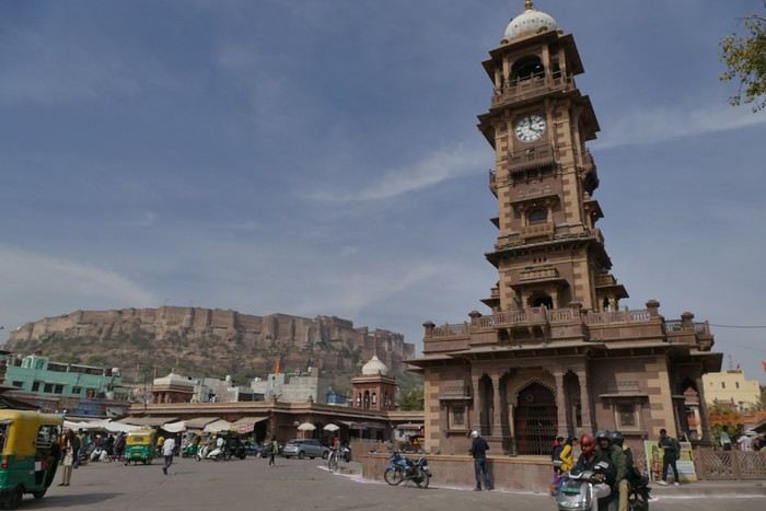
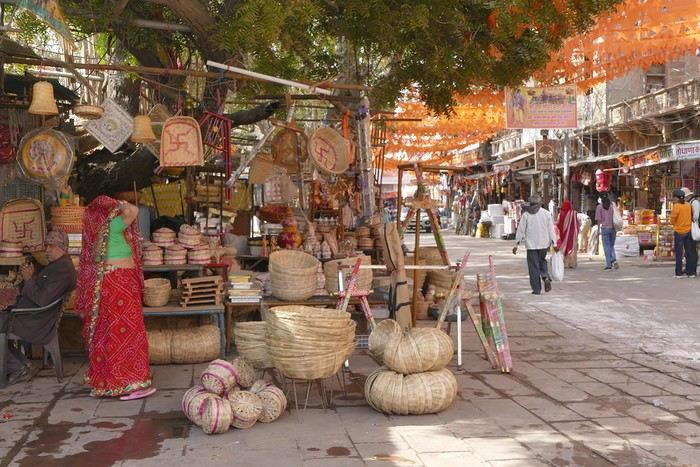
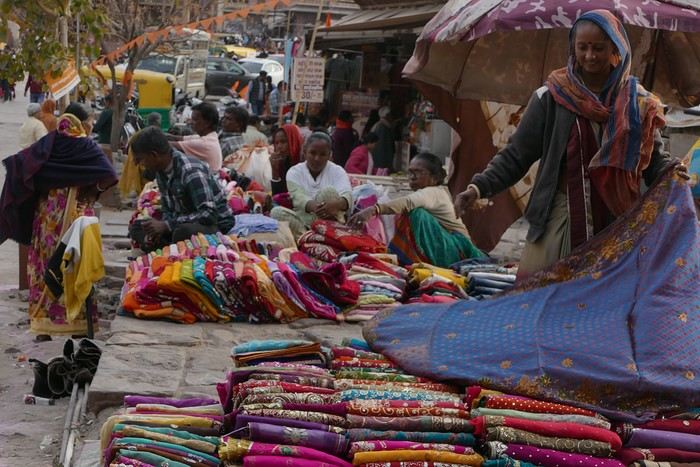
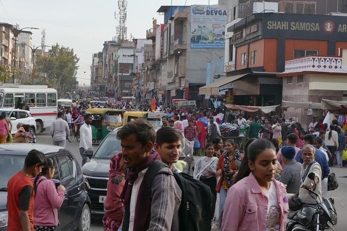
A market lines the street leading to the tower, and the traffic is intense.
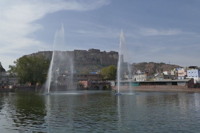
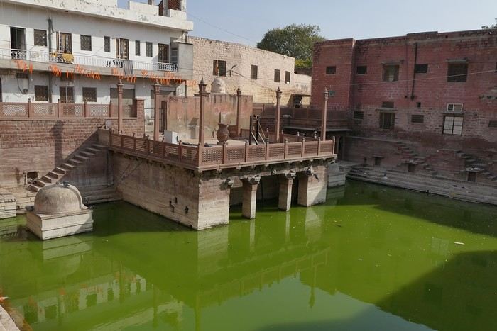
I set off in search of the stepwells and Gulab Sagar, a large basin with three water jets and a great view of Mehrangarh Fort. And yes, more baoris!
Toorji Ka Jhalra Bawdi isn’t far away. It’s a meet-up spot for tourists, with restaurants and terraces lining the area. The place is nice.
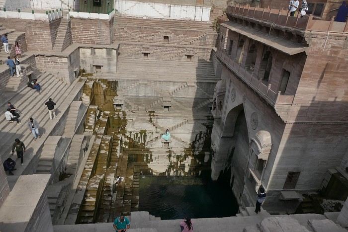
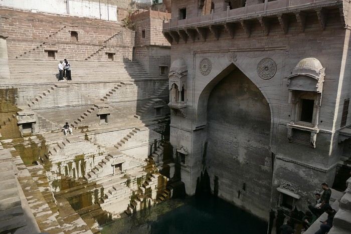
I looked for Mahila Bagh Ka Jhalra, went around in circles a bit, and finally found it right across from Gulab Sagar, where I’d already been. It’s not in good condition—it’s a shame it hasn’t been restored.
I went back through the clock tower area, found a currency exchange with a good rate, and booked my train tickets for the whole trip. The street was lively, with heavy traffic.
I was tired and headed back to the guesthouse. When I got there, I realized my phone wasn’t showing the right time, which gave me a chance to rest before going out for dinner. The Indigo restaurant is nearby and will be perfect.
Thursday, January 25: I left home at 4:30 AM and headed to Barcelona airport. The roads weren’t blocked by farmers yet, so I made the trip without any issues. I arrived at the airport at 7:10 AM, called Parkvia, and someone picked up my car 15 minutes later. All that was left was to check in my luggage. My Etihad flight was at 10:25 AM, which gave me time for breakfast. We landed in Abu Dhabi at 7:30 PM. The flight to Delhi was at 10:15 PM, the transfer went smoothly without any stress, and we arrived in Delhi at 3:00 AM. I couldn’t waste any time upon arrival because I had a flight to Jodhpur at 6:55 AM. I got to customs, and what a nice surprise—the hall was empty. I went through immediately, had my passport and visa checked, and everything was fine. I grabbed my bag quickly and looked for the transfer to T2, which is outside. You have to walk along the taxi parking lot and take the long corridors—it’s well signposted, and the transfer took 10 minutes. At first, I was a little stressed, not knowing how long customs would take, but in the end, I was early for my 6:55 AM flight. I’m even glad I booked this one, as it got me to Jodhpur at 8:20 AM.
When I arrived, I took an auto-rickshaw to Jodhpur Palace GH, which I’d booked on Booking. The welcome was nice, and I was given a room right away. I was hoping to rest a bit, but unfortunately, it was very noisy. I settled in, took a shower, and was ready to go out and explore the city. The owner stopped me as I was leaving and told me I had to change rooms—I had to repack my bag before heading out. He showed me the way to the clock tower, which is about a 15-minute walk away.
A market lines the street leading to the tower, and the traffic is intense.
I set off in search of the stepwells and Gulab Sagar, a large basin with three water jets and a great view of Mehrangarh Fort. And yes, more baoris!
Toorji Ka Jhalra Bawdi isn’t far away. It’s a meet-up spot for tourists, with restaurants and terraces lining the area. The place is nice.
I looked for Mahila Bagh Ka Jhalra, went around in circles a bit, and finally found it right across from Gulab Sagar, where I’d already been. It’s not in good condition—it’s a shame it hasn’t been restored.
I went back through the clock tower area, found a currency exchange with a good rate, and booked my train tickets for the whole trip. The street was lively, with heavy traffic.
I was tired and headed back to the guesthouse. When I got there, I realized my phone wasn’t showing the right time, which gave me a chance to rest before going out for dinner. The Indigo restaurant is nearby and will be perfect.
Wednesday, April 1st
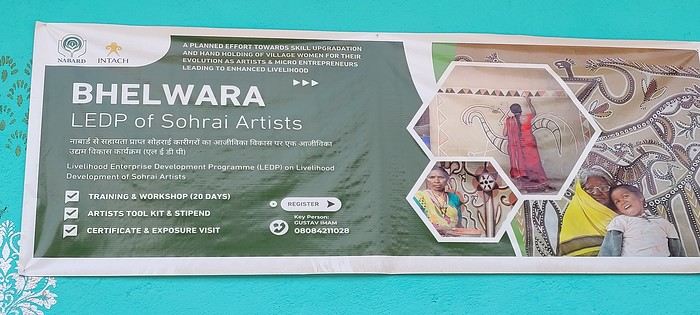
Hazaribagh I’ve got a meet-up with Adam Iman, a guide and painter. He picks me up from the hotel at 10 AM. Another traveler from Bangalore is supposed to join us, but while we wait for him to arrive, Adam takes me to see the paintings his mother and sister created at Hazaribagh station. The town became famous thanks to these murals, which can also be found in several surrounding villages. This art form has earned recognition and is now protected, a sign of its cultural importance. Once the visit is over, we go to pick up the other traveler and then head to our first village: Belwara, where Sohrai art is practiced. At the entrance, a sign proudly announces that we’re entering an artists’ village, where this art is created by women organized into micro-enterprises. Some even offer workshops for those who’d like to learn this tradition.
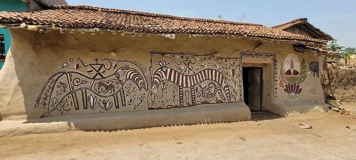
Sohrai art is tied to the harvest season, from October to mid-November. The motifs, in natural colors, celebrate fertility and abundance. The artists use pigments from the earth: red oxides, ochre, white kaolin, and black manganese. On the walls, you’ll see animals, fish, birds—all symbols of life and prosperity. As I look closer at the murals, I start to realize that each motif tells a story. Large animals like cows or bulls often take center stage. Their bodies are filled with intricate, almost hypnotic patterns. They symbolize wealth and prosperity for the household, as well as the deep respect for cattle, which are essential to daily life. On some facades, elephants stand out—massive and decorated with the same precision. They evoke quiet strength and protection. But it’s when I stop in front of one of the houses that I really take the time to look. The wall, a soft ochre, is entirely covered in murals. Two large animals stretch out on either side of the door, their elongated bodies fitting the length of the wall. Their silhouettes are filled with geometric patterns and incredibly fine curved lines, as if every space was patiently filled. Around them, stylized plants, flowers, and small decorative elements fill every gap. The door, dark and worn, becomes almost the silent center of the composition, framed by these living, protective forms. To the right, a more colorful motif catches the eye—a flower or a stylized lamp—like a touch of light on the earth. The whole thing gives an impression of perfect balance, between the rigor of the patterns and the freedom of the gesture.
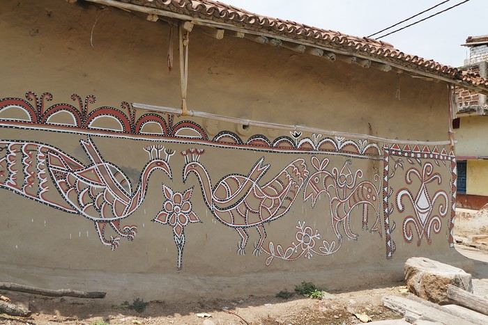
Elsewhere, birds and freer forms bring movement. Peacocks, recognizable by their stylized silhouettes, embody beauty and vitality, while fish symbolize water, fertility, and the continuity of life.
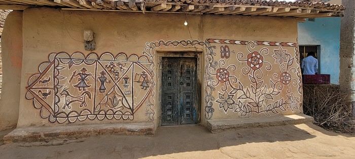
 On some paintings, the scenes become almost narrative: you can make out figures, everyday gestures, like a memory of the village inscribed in the walls. The decorative frames around the doors aren’t left to chance either—they symbolically protect the house, like a boundary between the inside and the outside world.
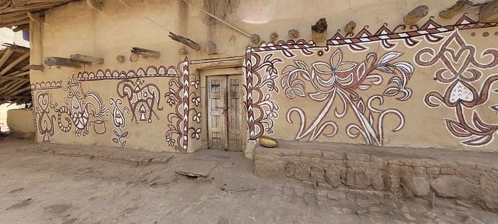
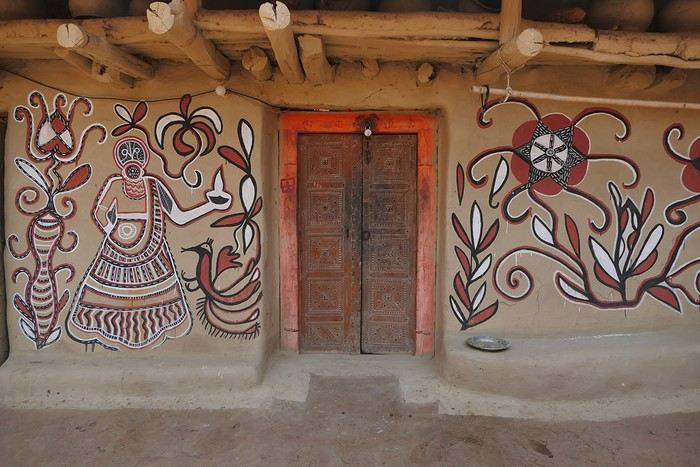
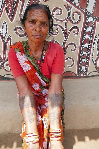
During the Sohrai festival, cattle are led into the jungle in the morning. Meanwhile, the women finish the *aripans*—these floor paintings—and continue the wall murals. Around noon, the animals return to the village, and the bulls’ horns are anointed with oil and vermilion in a gesture of gratitude, amid the vibrant colors adorning the houses. We visit several artists, including Parvat Devi, a well-known woman who has received many awards. Her arms are adorned with intriguing tattoos, which I’ll talk about in more detail later.
On another wall, the style changes completely. Here, no massive animals—just birds occupying the space, light and graceful, as if caught in mid-movement. Two silhouettes face each other, their long necks arched almost like mirrors, while their outstretched wings seem to vibrate with the patterns that compose them.
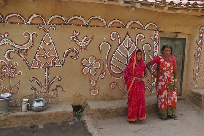
The design is more graphic, almost airy. The lines are smoother, more fluid, as if drawn in one confident stroke. The birds’ bodies aren’t solid—they’re filled with repetitive motifs like scales, stylized feathers, and spirals, giving a sense of continuous movement. Around them, everything comes to life: flowers burst open, arabesques swirl, and even the simplest shapes seem alive. What strikes me here is the sense of lightness. Where the large animals evoked stability and grounding, these birds bring something freer, almost joyful. They seem to embody movement, the circulation of life, like a breath flowing through the village.
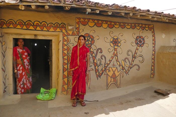
The colors remain the same—deep reds, intense blacks, and chalky white—but the rhythm is different. Faster, more spontaneous. As if each wall had its own personality, while still speaking the same language.
That’s probably why I’m so moved. I’d heard about these paintings from my friend Raja, and last year, I saw an exhibition in a village near my home. That first encounter made me want to come here. But seeing them in person is a whole different experience. These paintings are unique. This ancient art is passed down from mother to daughter, or mother-in-law to daughter-in-law, in a quiet, deeply living continuity. At first glance, it might seem almost childlike in its simplicity and pared-down forms. And yet, everything is thought out, balanced, mastered. Nothing is left to chance.
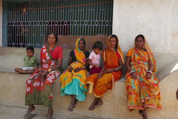
That apparent simplicity, combined with such rich symbolism, touches me deeply. There’s something sincere and essential in these walls—and that’s what moves me.
Hazaribagh I’ve got a meet-up with Adam Iman, a guide and painter. He picks me up from the hotel at 10 AM. Another traveler from Bangalore is supposed to join us, but while we wait for him to arrive, Adam takes me to see the paintings his mother and sister created at Hazaribagh station. The town became famous thanks to these murals, which can also be found in several surrounding villages. This art form has earned recognition and is now protected, a sign of its cultural importance. Once the visit is over, we go to pick up the other traveler and then head to our first village: Belwara, where Sohrai art is practiced. At the entrance, a sign proudly announces that we’re entering an artists’ village, where this art is created by women organized into micro-enterprises. Some even offer workshops for those who’d like to learn this tradition.
Sohrai art is tied to the harvest season, from October to mid-November. The motifs, in natural colors, celebrate fertility and abundance. The artists use pigments from the earth: red oxides, ochre, white kaolin, and black manganese. On the walls, you’ll see animals, fish, birds—all symbols of life and prosperity. As I look closer at the murals, I start to realize that each motif tells a story. Large animals like cows or bulls often take center stage. Their bodies are filled with intricate, almost hypnotic patterns. They symbolize wealth and prosperity for the household, as well as the deep respect for cattle, which are essential to daily life. On some facades, elephants stand out—massive and decorated with the same precision. They evoke quiet strength and protection. But it’s when I stop in front of one of the houses that I really take the time to look. The wall, a soft ochre, is entirely covered in murals. Two large animals stretch out on either side of the door, their elongated bodies fitting the length of the wall. Their silhouettes are filled with geometric patterns and incredibly fine curved lines, as if every space was patiently filled. Around them, stylized plants, flowers, and small decorative elements fill every gap. The door, dark and worn, becomes almost the silent center of the composition, framed by these living, protective forms. To the right, a more colorful motif catches the eye—a flower or a stylized lamp—like a touch of light on the earth. The whole thing gives an impression of perfect balance, between the rigor of the patterns and the freedom of the gesture.
Elsewhere, birds and freer forms bring movement. Peacocks, recognizable by their stylized silhouettes, embody beauty and vitality, while fish symbolize water, fertility, and the continuity of life.
On some paintings, the scenes become almost narrative: you can make out figures, everyday gestures, like a memory of the village inscribed in the walls. The decorative frames around the doors aren’t left to chance either—they symbolically protect the house, like a boundary between the inside and the outside world.During the Sohrai festival, cattle are led into the jungle in the morning. Meanwhile, the women finish the *aripans*—these floor paintings—and continue the wall murals. Around noon, the animals return to the village, and the bulls’ horns are anointed with oil and vermilion in a gesture of gratitude, amid the vibrant colors adorning the houses. We visit several artists, including Parvat Devi, a well-known woman who has received many awards. Her arms are adorned with intriguing tattoos, which I’ll talk about in more detail later.
On another wall, the style changes completely. Here, no massive animals—just birds occupying the space, light and graceful, as if caught in mid-movement. Two silhouettes face each other, their long necks arched almost like mirrors, while their outstretched wings seem to vibrate with the patterns that compose them.
The design is more graphic, almost airy. The lines are smoother, more fluid, as if drawn in one confident stroke. The birds’ bodies aren’t solid—they’re filled with repetitive motifs like scales, stylized feathers, and spirals, giving a sense of continuous movement. Around them, everything comes to life: flowers burst open, arabesques swirl, and even the simplest shapes seem alive. What strikes me here is the sense of lightness. Where the large animals evoked stability and grounding, these birds bring something freer, almost joyful. They seem to embody movement, the circulation of life, like a breath flowing through the village.
The colors remain the same—deep reds, intense blacks, and chalky white—but the rhythm is different. Faster, more spontaneous. As if each wall had its own personality, while still speaking the same language.
That’s probably why I’m so moved. I’d heard about these paintings from my friend Raja, and last year, I saw an exhibition in a village near my home. That first encounter made me want to come here. But seeing them in person is a whole different experience. These paintings are unique. This ancient art is passed down from mother to daughter, or mother-in-law to daughter-in-law, in a quiet, deeply living continuity. At first glance, it might seem almost childlike in its simplicity and pared-down forms. And yet, everything is thought out, balanced, mastered. Nothing is left to chance.
That apparent simplicity, combined with such rich symbolism, touches me deeply. There’s something sincere and essential in these walls—and that’s what moves me.
We took this trip from September 12 to October 7, 2022. I didn’t post this travel journal earlier in Voyage Forum because the site wasn’t back up yet (and also because I was short on time).
Then, at the end of 2024, I made a promise to a friend: to publish my travel journal on VF. So here it is!
 We took off from Paris in the late afternoon on September 12 and arrived in Tashkent around 7:15 AM on the 13th.
This trip was the result of long contemplation and preparation (it was originally planned for the year of the lockdown (2020) and was prepared with the help and advice of Nasrullo Jumanov from Turquoise Travel.
Stages and Itinerary
Stage 1: Tashkent - September 13 and 14
Stage 2: Ferghana Valley – September 15 to 17
Stage 3: Nukus and Moynaq - September 18 and 19
Stage 4: Mysterious Khiva - September 20 to 22
Stage 5: Holy Bukhara - September 23 to 26
Stage 6: Asraf - September 27 and 28
Stage 7: Mythical Samarkand - September 29 to October 2
Stage 8: Tersak (via Shakhrisabz and Urgut) – October 3 and 4
Stage 9: Samarkand – October 5 and 6
Stage 10: Tashkent/Istanbul/Paris – October 6 and 7
Stage 1: Tashkent
September 13
At the airport exit, we were greeted by the owner of our B&B (B&B Gulnara).
Today was all about recovery and our first steps in the capital. Our first currency exchange made us feel like sudden millionaires.
Our first stroll down the avenue leading to Chorsu Market introduced us to the fact that 80 to 90% of the cars here are white Chevrolets.
A walk under the arcades facing Chorsu: hardware stores, cabinetmakers, lute makers (one of them gave me a little concert/demo of a few string instruments).
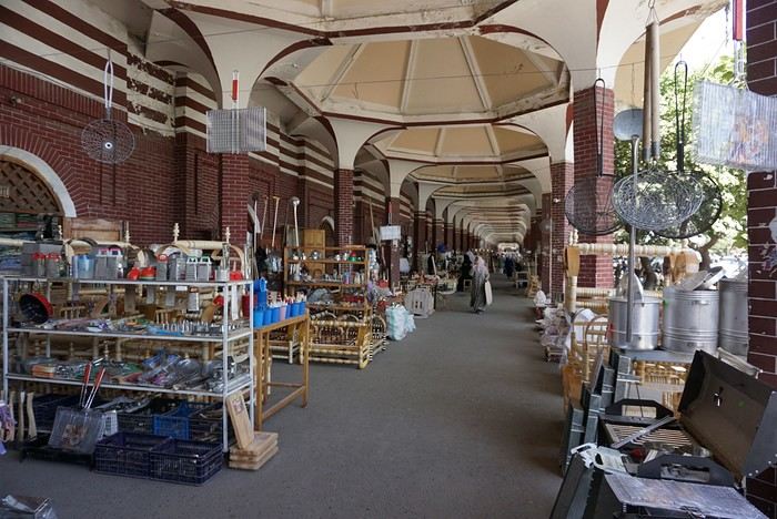
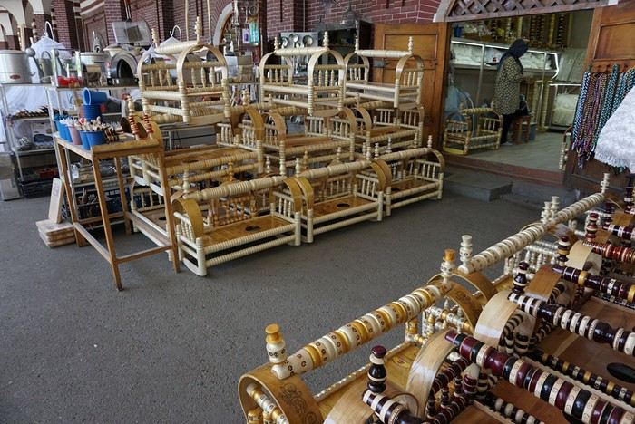
As we entered the market, many vendors called out to us, including this florist who asked where we were from: ‘France? Ah! Macron! PSG!’ He then recited a list of players from the Parisian team as well as past (Platini, Zidane, etc.) and current (Giroud, Griezmann, Mbappé, etc.) French national team players. Since we’re more into rugby (we live near Toulouse), he knew more players than I did!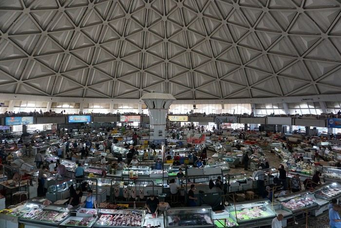
The market sprawls outside around the large circular, multi-story hall. We bought some grapes and bottles of freshly squeezed pomegranate juice for just a few sums. This evening, we had a meet-up with Nasrullo. The reunion was very warm: we’d been exchanging messages for over two years, and I’d been ‘torturing’ him with changes to our itinerary and trip duration. We were finally eager to meet, and honestly, I wasn’t disappointed—in fact, it was the opposite. Nasrullo was very attentive throughout our trip and always made sure, even from a distance (and most often from a distance!), that everything went smoothly. His goal was for us to leave delighted with our trip and, why not, indirectly become ambassadors for this destination. September 14 Breakfast with Nasrullo, then we set off with him by taxi to explore some of the capital’s sites.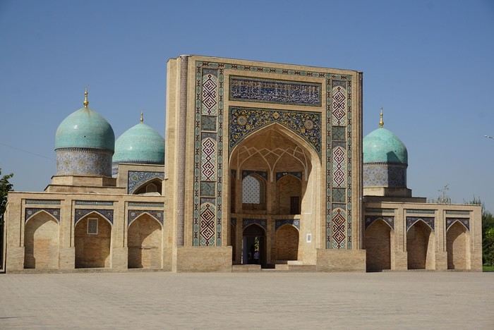
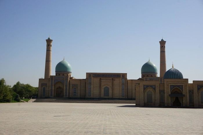
We started by visiting the Khazrati Imam complex, which includes the mausoleum of Kaffal Shashi, the Barak Khan and Muyi Muborak madrasas, and the great Khazrati Imam Mosque with its immense prayer hall.
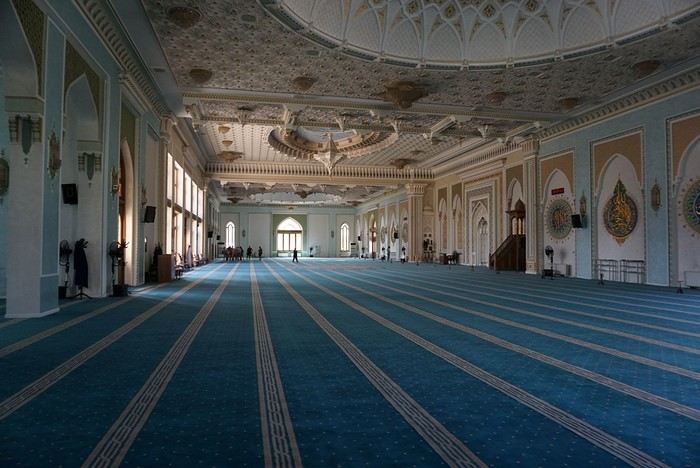
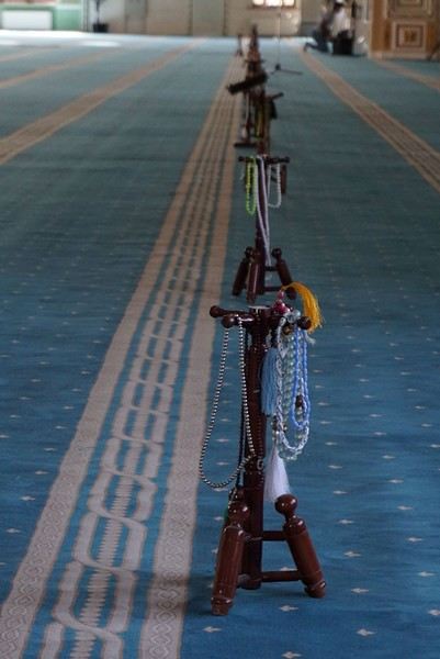
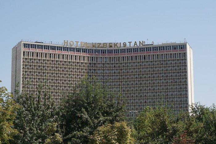
In the Muyi Muborak madrasa, now a museum, you can see the oldest Quran in the world. It was written by three religious scholars, including the secretary of the Prophet Muhammad, on large ‘pages’ made of antelope skin. Next, we explored Soviet-era Tashkent, discovering its parks, canals, and squares: Independence Square with its storks and phoenixes, Amir Temur Square with its large statue and, in the background, the massive Soviet-era hotel that has become one of Tashkent’s iconic buildings. Nasrullo took us through Broadway Boulevard and along what he calls ‘Tashkent’s Montmartre’… Well, it’s far, very far from Montmartre (in every sense of the word!). Then we took the metro to Chorsu station. Rush hour is pretty much the same everywhere in the metro… When we arrived at Chorsu, it was time to say goodbye. Nasrullo had to head back to Samarkand. Before leaving, he recommended some chaikhanas at the end of the galleries facing the market. We ate there for just a few euros (2 or 3 € for two people). After eating, we headed back to our room to cool off (our B&B is about a 10-minute walk away).
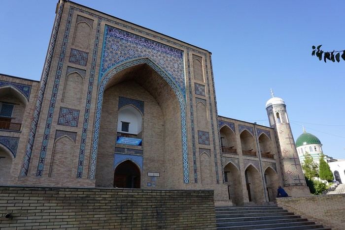
Around 4 PM, we set off to visit the Kokeldash Madrasa, which is still active. On the way, we stopped to watch some bread vendors and take a few photos. We were hesitating about buying some for our evening picnic when a young woman approached us. In perfect English, she asked: ‘Are you looking for something? Do you want to buy bread? Which one? How much?’ She then spoke to one of the vendors and negotiated the price. ‘Do you want one?’ And she took two. She paid directly. I took out my wallet to reimburse her, but she refused. It’s on the house! Then the vendor asked where we were from. And off we went again: Macron, PSG, football players… We’ll have to get used to it. The young woman smiled at the questions and comments, barely gave us time to thank her, and left as quickly as she had approached us.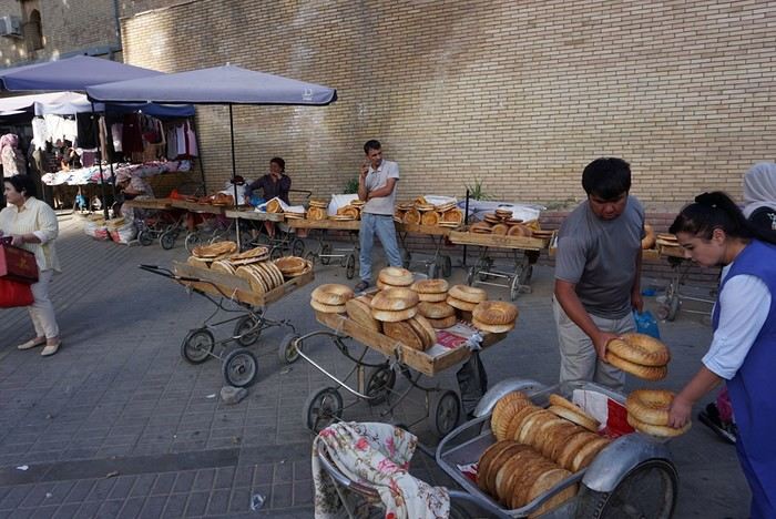
We continued our walk. Visited the madrasa. Then we crossed the boulevard to see the Tashkent Circus. I would’ve loved to go in and visit, but the ticket seller wouldn’t hear of it. We carried on around what should’ve been a park with old-fashioned rides and attractions. All we found was a construction site. Oh well! Back at our hotel, a message from Nasrullo was waiting for us. He had managed to change our train ticket for the next day. Instead of taking the 6:00 AM train, we’d take the 8:00 AM one. And instead of second class, we’d be in first class! Great! This evening, we had a picnic at one of the breakfast tables in the B&B courtyard. Under a shelter, the owner and his family were celebrating a birthday. The owner started by offering us some tea. Then they brought us some fruit (watermelon and melon). Finally, after the song, candles, and cake cutting, they brought us two generous slices of that beautiful birthday cake. Delicious!
We took off from Paris in the late afternoon on September 12 and arrived in Tashkent around 7:15 AM on the 13th.
This trip was the result of long contemplation and preparation (it was originally planned for the year of the lockdown (2020) and was prepared with the help and advice of Nasrullo Jumanov from Turquoise Travel.
Stages and Itinerary
Stage 1: Tashkent - September 13 and 14
Stage 2: Ferghana Valley – September 15 to 17
Stage 3: Nukus and Moynaq - September 18 and 19
Stage 4: Mysterious Khiva - September 20 to 22
Stage 5: Holy Bukhara - September 23 to 26
Stage 6: Asraf - September 27 and 28
Stage 7: Mythical Samarkand - September 29 to October 2
Stage 8: Tersak (via Shakhrisabz and Urgut) – October 3 and 4
Stage 9: Samarkand – October 5 and 6
Stage 10: Tashkent/Istanbul/Paris – October 6 and 7
Stage 1: Tashkent
September 13
At the airport exit, we were greeted by the owner of our B&B (B&B Gulnara).
Today was all about recovery and our first steps in the capital. Our first currency exchange made us feel like sudden millionaires.
Our first stroll down the avenue leading to Chorsu Market introduced us to the fact that 80 to 90% of the cars here are white Chevrolets.
A walk under the arcades facing Chorsu: hardware stores, cabinetmakers, lute makers (one of them gave me a little concert/demo of a few string instruments).As we entered the market, many vendors called out to us, including this florist who asked where we were from: ‘France? Ah! Macron! PSG!’ He then recited a list of players from the Parisian team as well as past (Platini, Zidane, etc.) and current (Giroud, Griezmann, Mbappé, etc.) French national team players. Since we’re more into rugby (we live near Toulouse), he knew more players than I did!
The market sprawls outside around the large circular, multi-story hall. We bought some grapes and bottles of freshly squeezed pomegranate juice for just a few sums. This evening, we had a meet-up with Nasrullo. The reunion was very warm: we’d been exchanging messages for over two years, and I’d been ‘torturing’ him with changes to our itinerary and trip duration. We were finally eager to meet, and honestly, I wasn’t disappointed—in fact, it was the opposite. Nasrullo was very attentive throughout our trip and always made sure, even from a distance (and most often from a distance!), that everything went smoothly. His goal was for us to leave delighted with our trip and, why not, indirectly become ambassadors for this destination. September 14 Breakfast with Nasrullo, then we set off with him by taxi to explore some of the capital’s sites.
We started by visiting the Khazrati Imam complex, which includes the mausoleum of Kaffal Shashi, the Barak Khan and Muyi Muborak madrasas, and the great Khazrati Imam Mosque with its immense prayer hall.
In the Muyi Muborak madrasa, now a museum, you can see the oldest Quran in the world. It was written by three religious scholars, including the secretary of the Prophet Muhammad, on large ‘pages’ made of antelope skin. Next, we explored Soviet-era Tashkent, discovering its parks, canals, and squares: Independence Square with its storks and phoenixes, Amir Temur Square with its large statue and, in the background, the massive Soviet-era hotel that has become one of Tashkent’s iconic buildings. Nasrullo took us through Broadway Boulevard and along what he calls ‘Tashkent’s Montmartre’… Well, it’s far, very far from Montmartre (in every sense of the word!). Then we took the metro to Chorsu station. Rush hour is pretty much the same everywhere in the metro… When we arrived at Chorsu, it was time to say goodbye. Nasrullo had to head back to Samarkand. Before leaving, he recommended some chaikhanas at the end of the galleries facing the market. We ate there for just a few euros (2 or 3 € for two people). After eating, we headed back to our room to cool off (our B&B is about a 10-minute walk away).
Around 4 PM, we set off to visit the Kokeldash Madrasa, which is still active. On the way, we stopped to watch some bread vendors and take a few photos. We were hesitating about buying some for our evening picnic when a young woman approached us. In perfect English, she asked: ‘Are you looking for something? Do you want to buy bread? Which one? How much?’ She then spoke to one of the vendors and negotiated the price. ‘Do you want one?’ And she took two. She paid directly. I took out my wallet to reimburse her, but she refused. It’s on the house! Then the vendor asked where we were from. And off we went again: Macron, PSG, football players… We’ll have to get used to it. The young woman smiled at the questions and comments, barely gave us time to thank her, and left as quickly as she had approached us.
We continued our walk. Visited the madrasa. Then we crossed the boulevard to see the Tashkent Circus. I would’ve loved to go in and visit, but the ticket seller wouldn’t hear of it. We carried on around what should’ve been a park with old-fashioned rides and attractions. All we found was a construction site. Oh well! Back at our hotel, a message from Nasrullo was waiting for us. He had managed to change our train ticket for the next day. Instead of taking the 6:00 AM train, we’d take the 8:00 AM one. And instead of second class, we’d be in first class! Great! This evening, we had a picnic at one of the breakfast tables in the B&B courtyard. Under a shelter, the owner and his family were celebrating a birthday. The owner started by offering us some tea. Then they brought us some fruit (watermelon and melon). Finally, after the song, candles, and cake cutting, they brought us two generous slices of that beautiful birthday cake. Delicious!
After about 12 hours of flying from Toulouse (via Paris), we landed in Bogotá six years after our first trip to Colombia. This time, our journey will be very different, with only this stop in the Colombian capital in common.
Our travel itinerary
Bogotá / La Macarena (Caño Cristales) / Villa de Leyva / Barichara / San Gil / Girón / Mompox / Ciénaga and the Santa Marta lagoon / Minca / Los Naranjos (Tayrona Park) / Bogotá.
Step 1: Bogotá (and Nemecon)
Bogotá (1/3)
This morning, we had a meet-up with Flora from Aventure Colombia, who helped me organize one of our stops, a few transfers, and tomorrow’s day trip, the program of which I changed at the last minute after deciding to skip the visit to the Salt Cathedral of Zipaquirá. Flora is a kind and lovely person, always available, and she did everything to answer my questions and give me advice.
She’s a local contact I highly recommend. Flora can help you plan your trip, whether you want a fully organized tour or, like us, just need assistance with a specific stop or one or more transfers between cities.
We left Flora after setting a meet-up for our return to Bogotá in a month. As we walked out of her agency, we headed to the wonderful Gold Museum, located just a hundred meters away. I was excited to revisit this amazing museum.
Note: Free entry for those over 60, regardless of nationality. Just show your passport.
Like six years ago, I was amazed by its museography, the beauty of the pieces on display, and that breathtaking shamanic room.
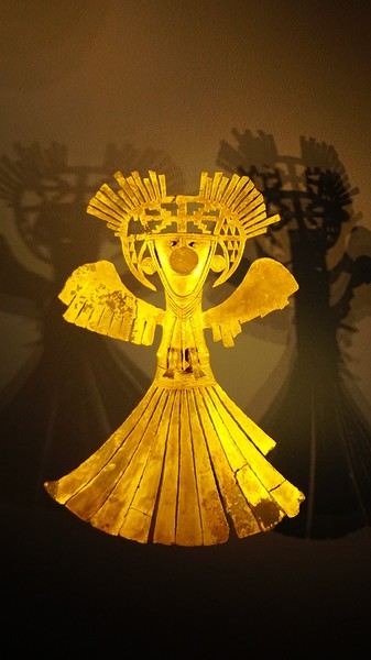
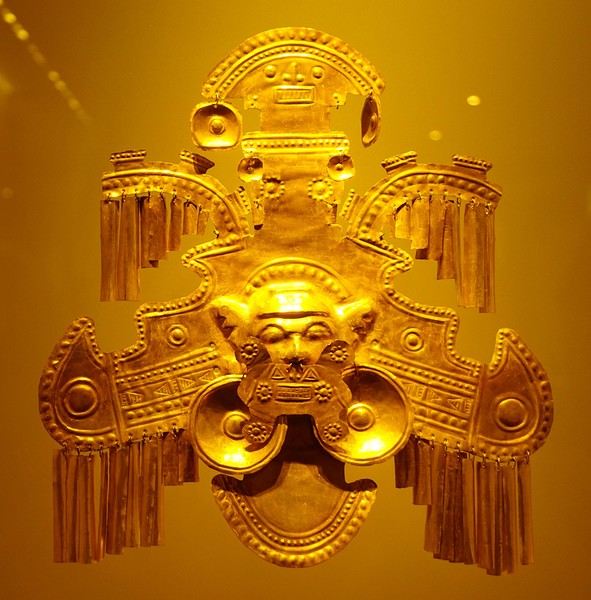
About two hours later, we decided to walk (careful, it’s a climb!) to the Monserrate cable car (3152m). Long wait to buy tickets and board the cable car! Once we arrived, a few raindrops, an impressive panoramic view of Bogotá’s vastness, a quick visit to the basilica (a pilgrimage site for Colombians), a walk through the tourist market, and at the top, plenty of small restaurants where we had our first Colombian meal. After our hearty lunch, we were lucky to see the sun return! No line for the descent. We then headed back to the hotel because Justine wanted to rest and recover from the trip. As for me, I continued my walk. I discovered a really nice craft market recommended by Flora, Pasaje Rivas, returned to Bolívar Square, and wandered through different streets, including the main pedestrian avenue (Calle 7), where there’s always something to see.
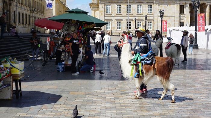
Tomorrow, a change of scenery as we head out for a hike in a small desert (Desierto de Chueca), located about 2 hours from Bogotá in the village of Nemecon. For this outing from Bogotá, with Flora’s help, we booked a car with a driver for the day. Flora also took care of booking the guide (since the site can only be visited with one). Nemecon (2/3) Today, we went to Nemecon to hike about 7.5 km in the ‘Desert of Checua.’ It’s nothing like sandy deserts! Instead, it’s geological formations sculpted by time, wind, and water. After two hours on the road—almost one of them spent navigating traffic jams with cars, trucks, buses, and a continuous flow of motorcycles on either side of our taxi—we reached Nemecon! The village center is really (too?) quiet. We met up with Deisy and headed toward the ‘desert,’ about twenty minutes away on a bumpy dirt road. Once there, a quick briefing, and off we went! Deisy didn’t stop talking (in Spanish) for over 3 hours!!! She told us so much about her region (flower farming, water management, traditions, songs, etc.), the origin of the site, and even mentioned Antonio Banderas, who filmed *The 33* in the village’s salt mine (the story of the survival of 33 Chilean miners after a collapse in their copper and gold mine). One hour of walking to reach the site, one hour to explore it, and one hour to return.
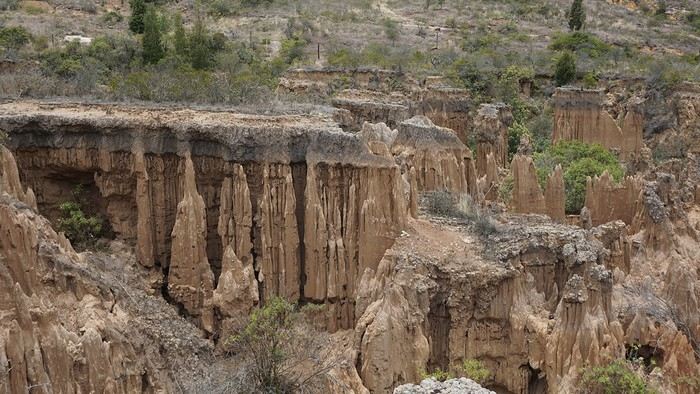
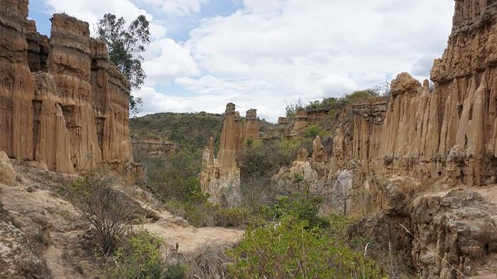
The advantage of this non-stop chatter was that it forced us to brush up on our Spanish at lightning speed. I even wondered if the effort to concentrate wasn’t more exhausting than the physical effort! Especially since on the way back, I got an oral quiz. Deisy wanted to make sure I remembered some of the information she’d given me during the visit: why is this rock white, that one red, and that one black? Back in the village, we had lunch at a restaurant recommended by Deisy before visiting the Nemecon salt mine. Before entering, a guide spent a good half-hour explaining the origin of the salt and the presence of many fossils in the area. Again, concentrating was tough because all the comments were exclusively in Spanish! An hour and a half wandering through the tunnels with a ‘lovely miner’s helmet’ on our heads!
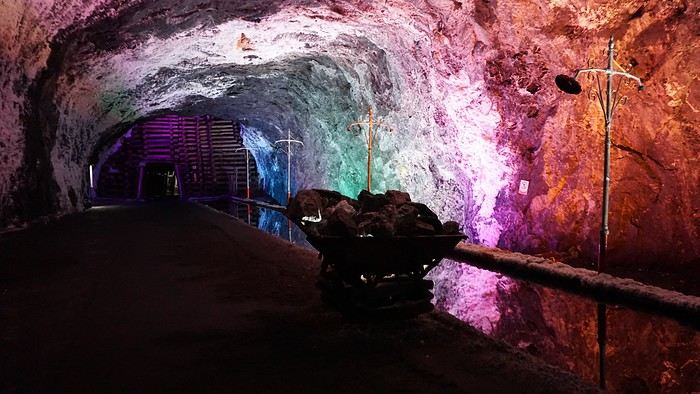
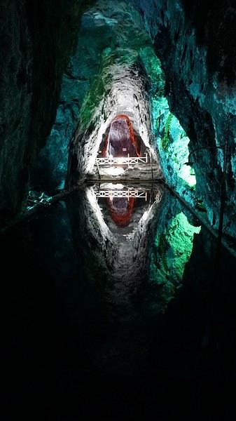
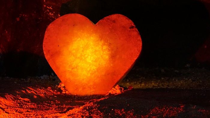
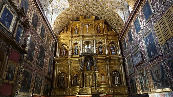
We met our driver at the mine entrance. The return to Bogotá was a bit faster, but traffic in the city center was still heavy! We arrived in front of our hotel between 8:00 and 8:30 PM. It’s been a pretty intense start to the trip! Tonight, our legs are tired. Hopefully, tomorrow will be a bit more relaxed! Bogotá (3/3) We started the day by visiting the Santa Clara Church Museum, located next to the presidential palace. Alejandra (from the local agency ‘Gaia Tours Colombia,’ which organized our stay in Caño Cristales (La Macarena)) had recommended this visit for its rich mural paintings.
A few hundred meters further, after crossing the Plaza Mayor again, we visited the cultural complex housing the Botero Museum, the Mint Museum, and the Bank of the Republic Art Museum. Note that entry is free for all three museums. Botero Museum: There are fewer works by Botero here than in the Medellín museum, but more paintings and sculptures by other artists, all from Botero’s private collection (donated to Colombia). Mint Museum: We limited ourselves to visiting one room (on Flora’s advice) where three gold and gemstone monstrances and a Christ with a crown of emerald thorns are displayed. Photos are not allowed. Art Museum: We visited two temporary exhibitions. Lunchtime came quickly. We had a good meal at a reasonably priced small restaurant in the La Candelaria micro-district, near the Chorro de Quevedo square. We decided to spend the afternoon wandering the streets and alleys of the historic center to discover local street art.
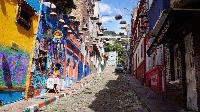
We also passed through very lively pedestrian streets. I also decided to revisit Pasaje Rivas to show Justine all the shops selling more or less artisanal products. Tomorrow morning, we fly to La Macarena at 10:30 AM. Not to dance (you’d be surprised if I told you we were going to take a South American dance class, right?!), but to visit the fabulous Caño Cristales, a river naturally colored by aquatic plants. The planned program includes hiking, horseback riding, canoeing, and swimming among these plants. This site was long inaccessible because the area was controlled by the FARC. Access and tourism development became possible after agreements and amnesty measures between the Colombian government and paramilitary groups. As in other regions, former FARC members have been able to transition into various tourism-related activities.
About two hours later, we decided to walk (careful, it’s a climb!) to the Monserrate cable car (3152m). Long wait to buy tickets and board the cable car! Once we arrived, a few raindrops, an impressive panoramic view of Bogotá’s vastness, a quick visit to the basilica (a pilgrimage site for Colombians), a walk through the tourist market, and at the top, plenty of small restaurants where we had our first Colombian meal. After our hearty lunch, we were lucky to see the sun return! No line for the descent. We then headed back to the hotel because Justine wanted to rest and recover from the trip. As for me, I continued my walk. I discovered a really nice craft market recommended by Flora, Pasaje Rivas, returned to Bolívar Square, and wandered through different streets, including the main pedestrian avenue (Calle 7), where there’s always something to see.
Tomorrow, a change of scenery as we head out for a hike in a small desert (Desierto de Chueca), located about 2 hours from Bogotá in the village of Nemecon. For this outing from Bogotá, with Flora’s help, we booked a car with a driver for the day. Flora also took care of booking the guide (since the site can only be visited with one). Nemecon (2/3) Today, we went to Nemecon to hike about 7.5 km in the ‘Desert of Checua.’ It’s nothing like sandy deserts! Instead, it’s geological formations sculpted by time, wind, and water. After two hours on the road—almost one of them spent navigating traffic jams with cars, trucks, buses, and a continuous flow of motorcycles on either side of our taxi—we reached Nemecon! The village center is really (too?) quiet. We met up with Deisy and headed toward the ‘desert,’ about twenty minutes away on a bumpy dirt road. Once there, a quick briefing, and off we went! Deisy didn’t stop talking (in Spanish) for over 3 hours!!! She told us so much about her region (flower farming, water management, traditions, songs, etc.), the origin of the site, and even mentioned Antonio Banderas, who filmed *The 33* in the village’s salt mine (the story of the survival of 33 Chilean miners after a collapse in their copper and gold mine). One hour of walking to reach the site, one hour to explore it, and one hour to return.
The advantage of this non-stop chatter was that it forced us to brush up on our Spanish at lightning speed. I even wondered if the effort to concentrate wasn’t more exhausting than the physical effort! Especially since on the way back, I got an oral quiz. Deisy wanted to make sure I remembered some of the information she’d given me during the visit: why is this rock white, that one red, and that one black? Back in the village, we had lunch at a restaurant recommended by Deisy before visiting the Nemecon salt mine. Before entering, a guide spent a good half-hour explaining the origin of the salt and the presence of many fossils in the area. Again, concentrating was tough because all the comments were exclusively in Spanish! An hour and a half wandering through the tunnels with a ‘lovely miner’s helmet’ on our heads!
We met our driver at the mine entrance. The return to Bogotá was a bit faster, but traffic in the city center was still heavy! We arrived in front of our hotel between 8:00 and 8:30 PM. It’s been a pretty intense start to the trip! Tonight, our legs are tired. Hopefully, tomorrow will be a bit more relaxed! Bogotá (3/3) We started the day by visiting the Santa Clara Church Museum, located next to the presidential palace. Alejandra (from the local agency ‘Gaia Tours Colombia,’ which organized our stay in Caño Cristales (La Macarena)) had recommended this visit for its rich mural paintings.
A few hundred meters further, after crossing the Plaza Mayor again, we visited the cultural complex housing the Botero Museum, the Mint Museum, and the Bank of the Republic Art Museum. Note that entry is free for all three museums. Botero Museum: There are fewer works by Botero here than in the Medellín museum, but more paintings and sculptures by other artists, all from Botero’s private collection (donated to Colombia). Mint Museum: We limited ourselves to visiting one room (on Flora’s advice) where three gold and gemstone monstrances and a Christ with a crown of emerald thorns are displayed. Photos are not allowed. Art Museum: We visited two temporary exhibitions. Lunchtime came quickly. We had a good meal at a reasonably priced small restaurant in the La Candelaria micro-district, near the Chorro de Quevedo square. We decided to spend the afternoon wandering the streets and alleys of the historic center to discover local street art.
We also passed through very lively pedestrian streets. I also decided to revisit Pasaje Rivas to show Justine all the shops selling more or less artisanal products. Tomorrow morning, we fly to La Macarena at 10:30 AM. Not to dance (you’d be surprised if I told you we were going to take a South American dance class, right?!), but to visit the fabulous Caño Cristales, a river naturally colored by aquatic plants. The planned program includes hiking, horseback riding, canoeing, and swimming among these plants. This site was long inaccessible because the area was controlled by the FARC. Access and tourism development became possible after agreements and amnesty measures between the Colombian government and paramilitary groups. As in other regions, former FARC members have been able to transition into various tourism-related activities.
Hi everyone,
I was wondering how the coronavirus pandemic has impacted the way you travel or plan your trips. I know some of these points have been discussed before, but what I’m interested in here is the concrete, present, and personal—no politics and nothing post-COVID.
Here are a few ideas—do any of these resonate with you?
- Traveling shorter distances / for shorter durations - Favoring rural or less crowded areas over urban or overcrowded ones - Opting for private transportation over public transit - Traveling solo or at least in pairs rather than in groups - Waiting until the crisis is over and saving money in the meantime - Reassessing health risks (and updating your first-aid kit/medications and vaccinations) - ...
I’m sure you’ll have other things to add. The floor is yours!
Hi everyone,
I’d love to share a little travel journal from our 14-day/12-night road trip with our two teens (14 and 17) in February/March 2020. A huge thank you to all of you who helped me plan this trip to South Africa—your patience with my endless questions was amazing!
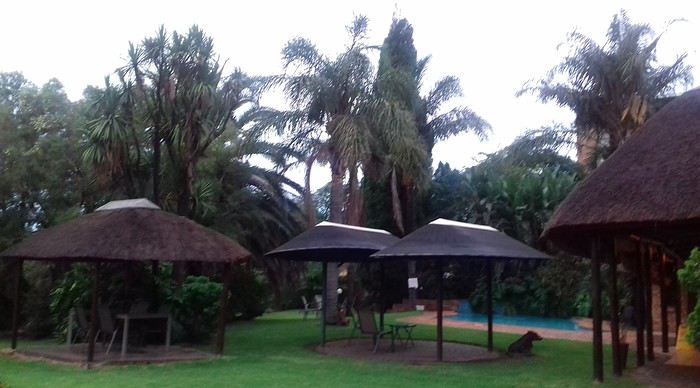
We left Lyon on Saturday, February 22 at 7:00 AM and arrived in Johannesburg at 10:00 PM after a short layover in Amsterdam. Flights cost 440 € per person (booked in October), with carry-on luggage. We added just one checked bag for the whole family (80 € round-trip with the free Flying Blue membership). Since we’d be moving around a lot, we packed light! In Lyon, we reserved parking at P5 in advance for 70 € for 14 days. The Air France/KLM flight was smooth. When we landed, we picked up our bags and had booked a night at the Aero Guest Lodge, just 5 minutes from the airport, with a free shuttle and breakfast. All you have to do is send a WhatsApp message when you arrive at the airport to let the shuttle driver know. The tricky part? Finding him in the terminal—he wasn’t holding a sign with the hotel’s name. 🤪 A South African called him for me since my English wasn’t great (and I had to get used to the accent 😛), and helped us spot the driver (who was actually less than 5 meters away!) with other guests. When we got to the hotel: all good, except we were 10 people in a van meant for 7. The room was spacious—one king-size bed and two single beds for the kids—with a simple but clean bathroom, a garden, pool, and breakfast (which we didn’t try). All for 65 €, so an awesome value!
 After a restful night, we woke up at 6:00 AM to catch the shuttle back to the airport. Just a heads-up: there’s only one shuttle per hour in the morning, and Kulula canceled our 9:00 AM flight, moving it to 8:00 AM—so no time for breakfast (it starts at 6:30).
We waited 15 minutes in the lovely garden for the driver, who dropped us off at the airport in 5 minutes.
We checked in for our flight to Cape Town, which cost around 40 € (including two checked bags per person).
We grabbed breakfast at the airport instead (less than 20 € for all four of us—one of the nice surprises of South Africa!), and arrived in Cape Town at 10:20 AM.
 After quickly picking up our bags, we headed to the Avis counter and left with a Toyota Corolla for 80 € for 4 days (rented with the Flying Blue card—free additional driver).
Everything’s on the left... not easy, but it works if you plan your route well.
We drove to our Airbnb in Constantia. We were surprised to see animals, bikes, and pedestrians on the highway!
We arrived around 11:30 AM at our rental—a huge house in the vineyards, in a super secure neighborhood, about 15-20 minutes from Hout Bay. It felt like Beverly Hills, but with super-high walls and barbed wire around the villas. 😕

We dropped off our bags, changed into shorts (it was around 30°C/86°F), and headed to the Bay Harbour Market in Hout Bay. We had lunch there—such a great vibe! We wandered through the stalls, everyone picked their own dish, and we sat down on the terrace. There was music, artisans of all kinds... a really nice moment.

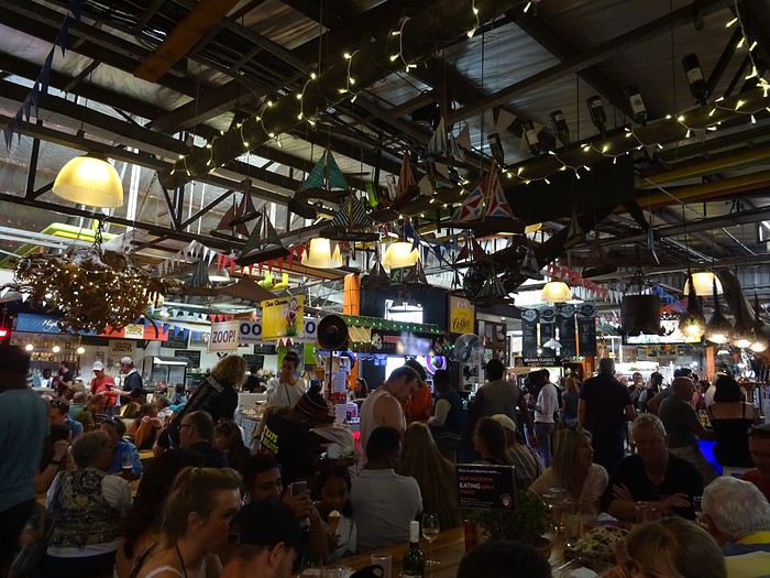
I’d withdrawn 50 € before leaving... and that gave me change to pay the parking attendant. Lunch cost around 30 € for four, including food and drinks.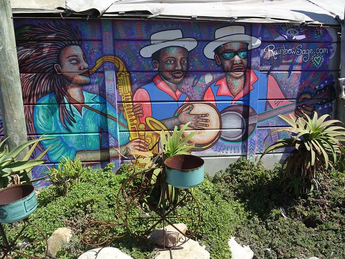

After browsing the artisan stalls, we headed to Hout Bay Beach near the restaurant, Marina Wharf (another small tip for the parking attendant—we’d have to get used to that!). We stopped to admire the sea lions. An ice cream for 1 €? No way we were saying no! 🙂
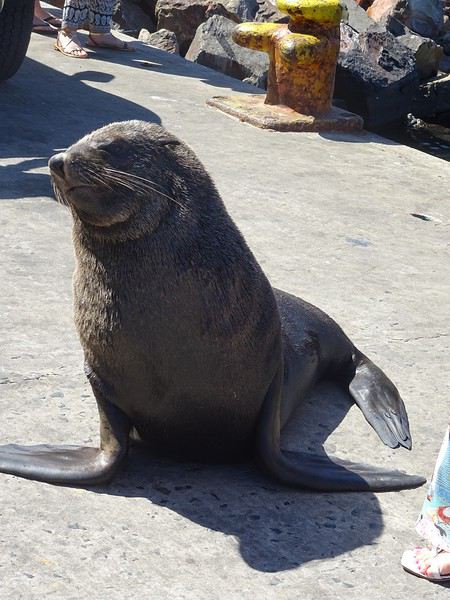
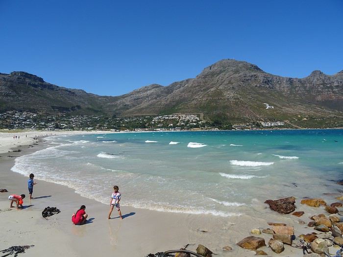
The fatigue was starting to hit, so we headed to the grocery store 10 minutes away (Constantia shopping center) and then had an aperitif in front of the vineyards, opening a delicious bottle of white wine.
I’d love to share a little travel journal from our 14-day/12-night road trip with our two teens (14 and 17) in February/March 2020. A huge thank you to all of you who helped me plan this trip to South Africa—your patience with my endless questions was amazing!
We left Lyon on Saturday, February 22 at 7:00 AM and arrived in Johannesburg at 10:00 PM after a short layover in Amsterdam. Flights cost 440 € per person (booked in October), with carry-on luggage. We added just one checked bag for the whole family (80 € round-trip with the free Flying Blue membership). Since we’d be moving around a lot, we packed light! In Lyon, we reserved parking at P5 in advance for 70 € for 14 days. The Air France/KLM flight was smooth. When we landed, we picked up our bags and had booked a night at the Aero Guest Lodge, just 5 minutes from the airport, with a free shuttle and breakfast. All you have to do is send a WhatsApp message when you arrive at the airport to let the shuttle driver know. The tricky part? Finding him in the terminal—he wasn’t holding a sign with the hotel’s name. 🤪 A South African called him for me since my English wasn’t great (and I had to get used to the accent 😛), and helped us spot the driver (who was actually less than 5 meters away!) with other guests. When we got to the hotel: all good, except we were 10 people in a van meant for 7. The room was spacious—one king-size bed and two single beds for the kids—with a simple but clean bathroom, a garden, pool, and breakfast (which we didn’t try). All for 65 €, so an awesome value!
After a restful night, we woke up at 6:00 AM to catch the shuttle back to the airport. Just a heads-up: there’s only one shuttle per hour in the morning, and Kulula canceled our 9:00 AM flight, moving it to 8:00 AM—so no time for breakfast (it starts at 6:30).
We waited 15 minutes in the lovely garden for the driver, who dropped us off at the airport in 5 minutes.
We checked in for our flight to Cape Town, which cost around 40 € (including two checked bags per person).
We grabbed breakfast at the airport instead (less than 20 € for all four of us—one of the nice surprises of South Africa!), and arrived in Cape Town at 10:20 AM.
After quickly picking up our bags, we headed to the Avis counter and left with a Toyota Corolla for 80 € for 4 days (rented with the Flying Blue card—free additional driver).
Everything’s on the left... not easy, but it works if you plan your route well.
We drove to our Airbnb in Constantia. We were surprised to see animals, bikes, and pedestrians on the highway!
We arrived around 11:30 AM at our rental—a huge house in the vineyards, in a super secure neighborhood, about 15-20 minutes from Hout Bay. It felt like Beverly Hills, but with super-high walls and barbed wire around the villas. 😕We dropped off our bags, changed into shorts (it was around 30°C/86°F), and headed to the Bay Harbour Market in Hout Bay. We had lunch there—such a great vibe! We wandered through the stalls, everyone picked their own dish, and we sat down on the terrace. There was music, artisans of all kinds... a really nice moment.
I’d withdrawn 50 € before leaving... and that gave me change to pay the parking attendant. Lunch cost around 30 € for four, including food and drinks.
After browsing the artisan stalls, we headed to Hout Bay Beach near the restaurant, Marina Wharf (another small tip for the parking attendant—we’d have to get used to that!). We stopped to admire the sea lions. An ice cream for 1 €? No way we were saying no! 🙂
The fatigue was starting to hit, so we headed to the grocery store 10 minutes away (Constantia shopping center) and then had an aperitif in front of the vineyards, opening a delicious bottle of white wine.
Here we go...
It’s been almost a month since we got back, and my head is still over there... Just like every time... For my own sake, I know travel journals are useful for travelers planning a trip to a country. But selfishly, they’re also helpful for me—to put the final stone on each journey and revisit it from time to time, just for the memories...
So, this trip won’t be any different, and I invite you to follow along on our Andean adventure, from Lima to the Southern Lipez, from December 16, 2016, to January 14, 2017. It’s a chronological journal because I don’t know how to approach it any other way. It doesn’t hold any absolute truths—just my experiences and feelings, which are obviously personal and not objective!
But if it inspires you to visit these magical countries (and I assume you’re already interested if you’re here) or gives you a couple of tips, then I’ll consider it a win!
So, let’s hit the road for the land of wide-open spaces!
It’s been almost a month since we got back, and my head is still over there... Just like every time... For my own sake, I know travel journals are useful for travelers planning a trip to a country. But selfishly, they’re also helpful for me—to put the final stone on each journey and revisit it from time to time, just for the memories...
So, this trip won’t be any different, and I invite you to follow along on our Andean adventure, from Lima to the Southern Lipez, from December 16, 2016, to January 14, 2017. It’s a chronological journal because I don’t know how to approach it any other way. It doesn’t hold any absolute truths—just my experiences and feelings, which are obviously personal and not objective!
But if it inspires you to visit these magical countries (and I assume you’re already interested if you’re here) or gives you a couple of tips, then I’ll consider it a win!
So, let’s hit the road for the land of wide-open spaces!
An 80-Day Tour of Southern Africa
Back in South Africa
January 12, 2013, 5:30 AM, Flight BA043 London-Cape Town
Directly below, Windhoek glittered like a tangle of fairy lights still lit and tossed into a box.
The horizon, edged in purple, was setting up a backup fireworks display, and suddenly, like a cherry on the platter and with unbearable intensity, in less than two minutes the entire sun revealed a gray dam and then a vast, untouched massif.
A few more minutes and the glare to the east of the plane was total. In Africa, the sun is swift.
We still had a France to cross before landing, but it felt as if we were already there. To the west, the raking light revealed what looked like acne and long, swollen scars in a desert region that might be the Swartkloofberg. Further still, straight as far as the eye could see, the two parallel tracks of a dirt road.
At 11,500 meters altitude and 940 km/h, we had a sense of stillness until the Orange River appeared, an incongruous serpent, gray edged with green.
The first South African settlements were dotted with trees providing shade, then rivers highlighted by continuous lines of vegetation.
Water and shade that make life possible.
We’ll return here by the backroads.
Half an hour from Cape Town, the plane tilted toward the sea, crossing plantations (likely citrus) and then an explosion of cultivated greenery in circles on either side of an unruly river. Finally, the coastline was no longer just sand and water—a frothy hem, a suture?
A peninsula came into view, forming two magnificent bays, and... a flight attendant firmly instructed me to return to my seat: we’d arrived!
The Colors of Cape Town
The city was dressed up as I like them—deserted, fluid, free of its vendors.
In the parking lot of the endless beach next to the commercial port north of the city, about two hundred people were unloading their goods in front of their pickups or combis, none of which were from this century: mixed-race, ageless Black people, and white folks who looked like they’d stepped out of another era.
After a few minutes, intrigued, I played a game: first looking at the merchandise, then imagining who was selling it, and finally looking at who was actually manning the stall. Tall Black vendors were selling what they often sell in Europe—leather, sunglasses, watches; mixed-race folks offered discount bundles, and the tanned older white people seemed to have emptied their attics.
We left with an antique tin kettle for morning tea over an open fire, a pack of five exercise books (that’s 600 pages to fill), Bill Bryson’s earliest stories in English, some snoek rillettes (a local fish), and—never seen before—tuna biltong and snoek biltong.
In so-called advanced countries, Sunday is for sports: white cyclists dressed like pros sweating diligently, Black street vendors running in loops at red lights to sell trash bags that day; white golfers losing their balls, which a scantily clad Black man retrieves from the water; under the sails of kite surf boards, it’s all blondes, and in the foam, joyful splashes from a bunch of Black kids.
Searching for an unusual spot for lunch, we drove through the fishing port looking for a dive and, at the end of a dead-end road with no warning, we arrived at the Shimmy Beach Club—quite the program.
The place, open for just three weeks, aims to be ultra-trendy. You could be in San Francisco, Lisbon’s docks, or St. Barth. This time, the "visible" staff was diverse, but the clientele was exclusively white, except for one mixed-race couple.
For this Sunday lunch, the women had pulled out all the stops, and local starlets—who’d make ours look tame—were turning the terrace into a frenzy.
At Cape Town’s port, the girls have *port*. The trend seems to be crochet dresses over swimsuits.
For two hours, a team of employees watered and raked the sand, starting over when they finished. A child in a floaty pink dress and a gold headband, but a future adventurer, stepped onto the freshly raked artificial beach sand for the first time.
A lanky mixed-race man dragged a hose across the ground, followed by a white woman—enchanted?—who then started watering the sand herself, carelessly splashing the glass terrace her colleague had just swept. I suspect a tacit work arrangement to keep everyone employed.
A galleon packed with tourists (are there any in the hold? Does it take tourists to Robben Island?) left the port. A helicopter took off in its wake. Trawlers returned, cutting through a ballet of catamarans, their waterlines well above the water: a bad catch.
If there’s one country where you can’t pretend to ignore skin color, it’s this one. The question is in everyone’s mind, and here more than anywhere else, it’s a decisive economic and political factor.
Columbine of Brittany
200 km north of Cape Town and 9,000 km south of the Breton coast, but on the same cold ocean, we camped on the shore of the Columbine Cape Nature Reserve, sheltered by a rocky chaos that, at first light tomorrow, would transport us to Perros-Guirec.
Our first encounter with wild animals wouldn’t end well for them: it was crayfish season, and they were the size of lobsters at Lorient’s fish market. Bought for R60 (5.5 €) a pair from kids in Pater Noster, they’d end up between two rocks, over a fire. But first, we had to pair the Chenin blanc with some snoek biltong.
With no wood, I lit a fire at dawn with dried seaweed and kelp, as if petrified; it gave off a smell of court-bouillon and... tires. Two hundred fathoms away, on an outpost, an army of cormorants stood at attention, unmoved among the frolicking seals.
At the reserve’s exit, the guard spoke French; Patrick Mwanba had arrived from Congo three years earlier to study, but the cost of living here forced him to drop out. He’d like to return home because life is cheaper there, but the war made him hesitate.
Ding ding dong! Vroom! Arf arf, Woof! Buzz! (A night from hell!)
I’d long planned to visit Calvinia, the center of a region known for extensive sheep farming. An excellent provincial museum, run by an enthusiastic curator, kept us too late to start the drive north.
So we camped in a tiny, charming campsite set up in the garden of a house. A few trees, a patch of resilient grass, and a view of a pretty lit-up steeple—what else?
Well, it turned out to be a sound-and-light show, with the pretty steeple chiming the hours and half-hours. Then suddenly, we were in the VIP stands of the Karoo-Kalahari Truck Race: roaring trucks paraded under our canvas windows, and we realized we were on the main road through town. To top it off, we enjoyed an uninterrupted canine cacophony, from the *arf arf* of little dogs to the *woof* of a mastiff. Oh, and some mosquitoes—the first ones—insisted on keeping us company in the tent, and we hadn’t yet bought the arsenal to neutralize them.
I walked through Calvinia at night; the house gardens weren’t fenced, nor did they have the «Armed Response» signs so common in the country.
The Kalahari Trails
(No, no, I haven’t converted to hiking.)
North of Calvinia, in the south of the Northern Cape, small towns follow one another up to Upington, about a hundred kilometers apart—welcome havens. Between them, with no trees in sight, we stopped in the shade of a motionless cloud: the temperature exceeded 40°C in mid-January.
We were almost out of the High Karoo and into a region of pans drying up, until the first red dunes appeared, precursors of the Kalahari. In the sparse veld vegetation, gatherings of quiver trees in the kopjes, and a caravan of camels without a handler or packs, marching in perfect formation across a pan (no, I hadn’t overdone the Windhoek at the last stop, and no, I wasn’t dehydrated enough to hallucinate).
The historic part of these towns, European in style, was built on the same plans as those in the American Midwest or the Australian Outback: a grid of streets wide enough to turn a wagon pulled by eight pairs of oxen. The architecture was Dutch-inspired, tropicalized with awnings.
Then came more recent housing, functional in style, where the wealthier mixed-race people—who make up the majority of this state—lived, and further on, the township, an assemblage of corrugated iron and plastic, like everywhere else.
Orange, Right Bank
North of Augrabies Falls National Park, on the other side of the Orange River, stretches a rugged and wild territory the size of fifty Groix islands, crisscrossed by a few tracks—the Riemvasmaak.
The inhabitants were driven out half a century ago for a military base, and as soon as President Mandela was elected, he made it a symbol by allowing the exiled populations to return. Several ethnic groups live here on almost nothing, in government-built shacks.
A community camp is set up in a small cirque at the end of a canyon that, while not in the history books, offers a good descent. By mid-afternoon, the air was at 44°C, but luckily there was a spring... except it was a hot spring, with water at 38°C. And they haven’t invented a reversible spring yet. Once the birds and baboons had settled in, in absolute silence and far from any light pollution, we enjoyed the stars like nowhere else (well, that’s what they claim in the region).
The Orange didn’t choose the easy path: arriving from Lesotho, it was almost at the ocean. The terrain to the south and north of this massif seemed easier to cross. Was it to avoid the curse of the Okavango, whose waters disappear into the sands without ever seeing the sea, that it chose this rocky route, thinking that at least the granite wouldn’t steal its water?
I Love You, I Eat You
In the dry bed of the Auob, it lay panting, head raised, alert, between its paws but head-to-tail, a tawny springbok, motionless.
A few minutes earlier, their story had been written in a lightning-fast chase, captured in photos by the driver of the car that alerted us.
It would be a long time before it started eating at the groin without breaking its surveillance.
Earlier, there was a lion lounging in the shade and hundreds of antelopes: springboks and gemsboks (oryx) in herds, hartebeests and steenboks alone. Strange pairs, apart several times, formed by a springbok and a gemsbok.
A few solitary jackals moved slightly sideways, looking furtive. Ostriches, alone, looking a bit dazed.
It was a lucky morning in the Kgalagadi (KTP).
In and Out
Kgalagadi, Nossob Camp.
We were at the very end of the almost-empty camp, ten meters from the fence, whose structure wouldn’t resist an elephant (though there aren’t any here), but it was electrified.
At dusk, on the other side, ten meters away, three lions passed in a row, as if on parade, seemingly focused on their goal and indifferent to the camp, though they glanced at it.
A jackal had gotten into the camp and was trying to get out without success while scavenging. I offered it two pieces of snoek biltong (Don’t feed the animals!) from three meters away—it smelled strong and had bones (bones in biltong!). When it passed by again, it sniffed but didn’t dare approach. Curled up in the chair, motionless, by the faint moonlight, I finally saw it come closer, grab the nearest piece, and move ten meters away to enjoy it (how many jackals know the finer points of sea biltong?). A little reassured, it came back for the second piece.
Another Morning
By morning, the jackal was gone, but our luck hadn’t left us. Two cheetahs again, who found me in the way and slowly moved toward a calmer shadow. Enough birds of prey to form a squadron, but they’re solitary hunters. Two ostriches busy with their dozen unruly chicks. And while we’re at it, a group of four Kalahari lions, sprawled under a thorny bush. Lots of oryx crossing the dunes and herds of red hartebeest. Kori bustards and secretary birds.
It was the first time the Kgalagadi had spoiled us so much.
Preamble
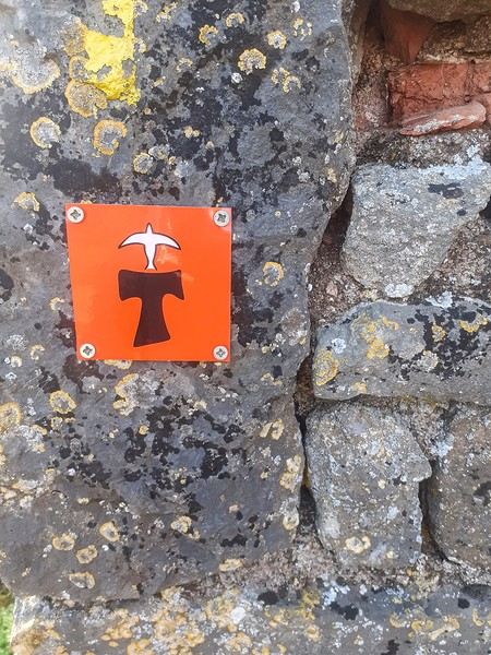
June 2024. While hiking with my brother on the GR 36 Tour du Morvan, I catch sight now and then of strange rectangular markers fixed to tree trunks. Against a bright orange background, a deep black Greek tau topped with a white dove. My first encounter with the Assisi Way. The Way of St. Francis: a pilgrimage route linking Vézelay in Burgundy to Assisi in Italy, covering nearly 1,800 km. It felt like an obvious next step—I immediately knew I’d take it on, attempt the adventure solo.
In the months that followed, I talked about my project to everyone—family, friends, my partner. An avalanche of comments, more or less the same but varying depending on each person’s character and life experiences. But deep down, it all boiled down to one legitimate question: why?
And the answers? Hesitant, awkward, partial, even confused. I quickly realized they weren’t so easy to find. It was as if my project seemed more like a whim, a kind of intimate caprice, rather than a well-thought-out plan. Of course, I knew the reasons that pushed me to leave—you always have to give some. Loved ones need to understand to feel reassured, and that’s understandable. But I fear that when I list them, they’ll sound like the same old checklist anyone embarking on this kind of journey might give. Of all the reasons I could mention, I’ll highlight just one here: the call of the road, the solo adventure that brings a powerful sense of freedom. A bit like Monsieur Seguin’s goat, who from her comfortable pen gazes longingly at the unconstrained horizon of the mountain. But if I’m being honest, I think I didn’t really know what I was looking for—or, more importantly, what I’d find. Deep down, when I reflect on it, one word keeps coming up that explains nothing and everything at once: desire.
Now well past sixty, I know that when I ask myself who I am or where I’m going, two things bring me fully back to myself: hiking and writing. And my intention was also to anchor this adventure through words, day by day. Writing down my feelings, emotions, discoveries, and reflections each evening. The famous travel journal that grounds the daily experience in reality. When I discovered the app "Polarstep," which was initially just meant to keep my loved ones updated and reassured, inform them of my progress, and maintain a connection, I found an opportunity to do it a little differently than usual. No retrospective notes polished up after returning, but spontaneous writing—recounting everything that crossed my mind during the day and publishing it immediately. A journey lived in real time.
This text is the exact transcription of my daily writings. Rereading them, I didn’t change a thing—just corrected a few mistakes and tweaked some awkward phrasing here and there. Short texts, fitting the format imposed by this kind of app. Writing as if addressing others.
Now, all that was left was to walk. April 18, 2026 – Vézelay.
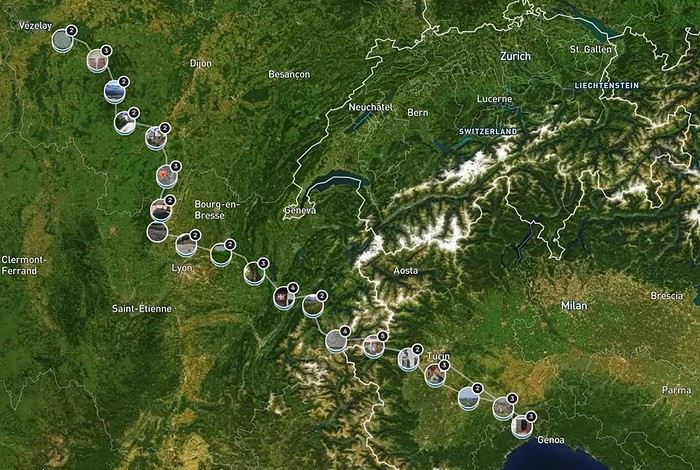
June 2024. While hiking with my brother on the GR 36 Tour du Morvan, I catch sight now and then of strange rectangular markers fixed to tree trunks. Against a bright orange background, a deep black Greek tau topped with a white dove. My first encounter with the Assisi Way. The Way of St. Francis: a pilgrimage route linking Vézelay in Burgundy to Assisi in Italy, covering nearly 1,800 km. It felt like an obvious next step—I immediately knew I’d take it on, attempt the adventure solo.
In the months that followed, I talked about my project to everyone—family, friends, my partner. An avalanche of comments, more or less the same but varying depending on each person’s character and life experiences. But deep down, it all boiled down to one legitimate question: why?
And the answers? Hesitant, awkward, partial, even confused. I quickly realized they weren’t so easy to find. It was as if my project seemed more like a whim, a kind of intimate caprice, rather than a well-thought-out plan. Of course, I knew the reasons that pushed me to leave—you always have to give some. Loved ones need to understand to feel reassured, and that’s understandable. But I fear that when I list them, they’ll sound like the same old checklist anyone embarking on this kind of journey might give. Of all the reasons I could mention, I’ll highlight just one here: the call of the road, the solo adventure that brings a powerful sense of freedom. A bit like Monsieur Seguin’s goat, who from her comfortable pen gazes longingly at the unconstrained horizon of the mountain. But if I’m being honest, I think I didn’t really know what I was looking for—or, more importantly, what I’d find. Deep down, when I reflect on it, one word keeps coming up that explains nothing and everything at once: desire.
Now well past sixty, I know that when I ask myself who I am or where I’m going, two things bring me fully back to myself: hiking and writing. And my intention was also to anchor this adventure through words, day by day. Writing down my feelings, emotions, discoveries, and reflections each evening. The famous travel journal that grounds the daily experience in reality. When I discovered the app "Polarstep," which was initially just meant to keep my loved ones updated and reassured, inform them of my progress, and maintain a connection, I found an opportunity to do it a little differently than usual. No retrospective notes polished up after returning, but spontaneous writing—recounting everything that crossed my mind during the day and publishing it immediately. A journey lived in real time.
This text is the exact transcription of my daily writings. Rereading them, I didn’t change a thing—just corrected a few mistakes and tweaked some awkward phrasing here and there. Short texts, fitting the format imposed by this kind of app. Writing as if addressing others.
Now, all that was left was to walk. April 18, 2026 – Vézelay.
Hi there,
In spring 2023, I headed to Romania by motorcycle. I’ve been going there for over 20 years—by car, bike, and plane—and I’ve really fallen for this country. I feel so at home there. The big difference this time? I had all the time in the world, no constraints at all.
I left the Paris region (IDF) and headed for the Sundgau, avoiding the motorways. I know a little hotel tucked away in the countryside there. The next day, I followed the Swiss border on a small road along the Lucelle River, which acts as the frontier. Around a bend, you cross to the other side and then back into France—kind of fun.

I crossed Switzerland via the motorway—I know the route well, so no sightseeing. I arrived in Austria, which I also know pretty well, and took the Arlberg Pass. It was deserted, everything was closed, and there was still snow.

The weather wasn’t great—it was raining—so I stopped for the night at a remote inn. Perfect for drying off! I set off in the rain the next morning and kept going. Gradually, the rain stopped. I took a detour through the Trentino-Alto Adige region and the Sella Pass. Up there, it was rain, snow, and a bit of black ice in a tunnel (wind + rain + sub-zero temps = skating rink).

I arrived in Burgenland to see the famous giant glass-and-metal grape cluster, the largest in Europe. The region is hilly, full of tiny roads, and covered in vineyards.

Burgenland

Then into Slovenia.

I stopped for the night at a winegrower’s B&B perched on a ridge straddling the Croatian border. The welcome was fantastic—I spent the evening with the owners and their friends who arrived later. The white wine was amazing! The next day, I hit the road again.

I headed for Vukovar, on the Danube, a symbol of resistance during the Balkan War. I found a really comfortable B&B by the river and stayed for two nights to explore. What a strange monument!

I visited the water tower, which you can go inside—it’s riddled with bullet holes. There’s an exhibition inside. I also checked out a museum of equipment used during the Balkan War. Since it’s in a barracks, it’s guarded. I asked if I could bring my motorcycle in, and a Croatian officer came to meet me and gave me permission, along with a sticker to put on the bike. I met some fellow bikers from Marseille riding beautiful vintage bikes.

I left Vukovar following the Danube toward Serbia. The rain caught up with me. The roads were busy, with construction causing mud everywhere and crazy truck drivers. At one point, I cut through the construction zone! I stopped for coffee in a village—it had a *Deliverance* vibe. Total silence when I walked in, and the owner gave me a suspicious look. Finally, the Romanian border... and the sun came out! The Romanian customs officer asked if I had anything to declare. "Yes—just happy to be back in Romania!" I stopped for the night at a *cabana* (mountain hut) lost in the forest. Chaos ensued—a tourist! So they rushed to get supplies, quench my thirst, give me a room, and then the owner took charge: țuică (plum brandy), omelette, beers... Everyone bent over backwards to make me happy.
I love these Romanian roads!


I passed through Băile Herculane, which isn’t as beautiful as it once was—everything’s run-down. What are they waiting for to restore this *Mittel Europa*-style spa town that’s still active?
I stopped at the birthplace of Constantin Brâncuși.

Keep your eyes peeled on the roads!

Via the Jiu Valley, I arrived in Craiova to visit my in-laws. A few days of laughs and outings. I picked up my wife at the airport.
My favorite brand

We took a trip to Horezu, a village famous for its beautiful ceramics.


After those few days together, I dropped my wife off at the airport, and the next day, I set off for Dobrogea, a region split in two after the war with Bulgaria. The road was dull—flat as far as the eye could see—but the sun was out. I followed a military convoy of about fifty vehicles, with orders not to overtake. I stopped by the roadside for some homemade *ciorbă* (sour soup). That evening, I stopped in Călărași. The next day, I crossed the Danube by ferry. There are two ferries—one goes to Bulgaria, the other stays in Romania.

A priest on board came over to bless the motorcycle, the rider, and the ferry. I arrived on the other side with some traffic. Dobrogea

It’s like that all the way to the Bulgarian border—no restaurants, hotels, or gas stations, just old collective farms. And it’s the same in Bulgaria! I stopped at Adamclisi, site of a major battle in Moesia (now Dobrogea) in 101–102 BC, one of Trajan’s most important Dacian Wars.

An oasis in the agricultural steppe.

I arrived at the Bulgarian border.

A customs officer—built like a weightlifter, shaved head, thick neck, and as square as a truck—saw me take this photo and came over to ask me to delete it. I did... but I didn’t empty the trash! The weather turned stormy. I arrived in Balchik, a resort town where the last queen of Romania, Maria, used to vacation.
The Black Sea and the Bulgarian coast

The weather wasn’t great, so I headed back to Romania to follow the coastline. Constanța and its casino

Then came the seaside resorts—just as ugly as each other: Neptun, Mangalia, Eforie Nord, Eforie Sud. I stopped at a B&B near the Danube Delta, in some random village. The welcome was nice. The next day, I headed for Dunavățu de Jos, the last stretch of tarmac in Romania. After that, it’s the Danube Delta. The area is flat and sandy, with typical houses featuring reed roofs.

Now, I’m following the Ukrainian border. I passed the last active quarantine station in Europe. I came across a funeral procession—it’s customary to honk as you pass. If you’re on foot, you cross yourself. When I arrived in Galați, it was raining. I boarded the ferry in a downpour. On board, we were packed in like sardines. As soon as the ramp hit land, the drivers rushed out, revving their engines and honking. I let them go and exited calmly. I continued toward the Székely Land. These are Hungarians who, back in the day, were border guards for the king. They’ve kept their own script (it looks like runes), their flag, and their independence streak. For them, Romania is Hungarian, despite the Treaty of Sèvres in 1920. There are still clashes between Romanians and Székely Hungarians now and then. Since I speak a bit of Romanian, I used it—logical, since it’s the language there—and it put everyone in a good mood! Székely flag

I passed through Bicaz Chei, arriving via one of my favorite kinds of roads. During a break, a bear came to check me out from a distance.

Bicaz Chei

I arrived at the "Heart of Jesus" monument, built by public subscription to thank God for sparing the village from severe flooding.

Now, I’m heading west—next stop, Transylvania, with the in-laws. On the road

Roma house

Bozorka—a Hungarian specialty... 450 grams of meat!
I made it back to France without any issues, already thinking about my next trip. Actually, I just got back from one!
I left the Paris region (IDF) and headed for the Sundgau, avoiding the motorways. I know a little hotel tucked away in the countryside there. The next day, I followed the Swiss border on a small road along the Lucelle River, which acts as the frontier. Around a bend, you cross to the other side and then back into France—kind of fun.
I crossed Switzerland via the motorway—I know the route well, so no sightseeing. I arrived in Austria, which I also know pretty well, and took the Arlberg Pass. It was deserted, everything was closed, and there was still snow.
The weather wasn’t great—it was raining—so I stopped for the night at a remote inn. Perfect for drying off! I set off in the rain the next morning and kept going. Gradually, the rain stopped. I took a detour through the Trentino-Alto Adige region and the Sella Pass. Up there, it was rain, snow, and a bit of black ice in a tunnel (wind + rain + sub-zero temps = skating rink).
I arrived in Burgenland to see the famous giant glass-and-metal grape cluster, the largest in Europe. The region is hilly, full of tiny roads, and covered in vineyards.
Burgenland
Then into Slovenia.
I stopped for the night at a winegrower’s B&B perched on a ridge straddling the Croatian border. The welcome was fantastic—I spent the evening with the owners and their friends who arrived later. The white wine was amazing! The next day, I hit the road again.
I headed for Vukovar, on the Danube, a symbol of resistance during the Balkan War. I found a really comfortable B&B by the river and stayed for two nights to explore. What a strange monument!
I visited the water tower, which you can go inside—it’s riddled with bullet holes. There’s an exhibition inside. I also checked out a museum of equipment used during the Balkan War. Since it’s in a barracks, it’s guarded. I asked if I could bring my motorcycle in, and a Croatian officer came to meet me and gave me permission, along with a sticker to put on the bike. I met some fellow bikers from Marseille riding beautiful vintage bikes.
I left Vukovar following the Danube toward Serbia. The rain caught up with me. The roads were busy, with construction causing mud everywhere and crazy truck drivers. At one point, I cut through the construction zone! I stopped for coffee in a village—it had a *Deliverance* vibe. Total silence when I walked in, and the owner gave me a suspicious look. Finally, the Romanian border... and the sun came out! The Romanian customs officer asked if I had anything to declare. "Yes—just happy to be back in Romania!" I stopped for the night at a *cabana* (mountain hut) lost in the forest. Chaos ensued—a tourist! So they rushed to get supplies, quench my thirst, give me a room, and then the owner took charge: țuică (plum brandy), omelette, beers... Everyone bent over backwards to make me happy.
I love these Romanian roads!
I passed through Băile Herculane, which isn’t as beautiful as it once was—everything’s run-down. What are they waiting for to restore this *Mittel Europa*-style spa town that’s still active?
I stopped at the birthplace of Constantin Brâncuși.
Keep your eyes peeled on the roads!
Via the Jiu Valley, I arrived in Craiova to visit my in-laws. A few days of laughs and outings. I picked up my wife at the airport.
My favorite brand
We took a trip to Horezu, a village famous for its beautiful ceramics.
After those few days together, I dropped my wife off at the airport, and the next day, I set off for Dobrogea, a region split in two after the war with Bulgaria. The road was dull—flat as far as the eye could see—but the sun was out. I followed a military convoy of about fifty vehicles, with orders not to overtake. I stopped by the roadside for some homemade *ciorbă* (sour soup). That evening, I stopped in Călărași. The next day, I crossed the Danube by ferry. There are two ferries—one goes to Bulgaria, the other stays in Romania.
A priest on board came over to bless the motorcycle, the rider, and the ferry. I arrived on the other side with some traffic. Dobrogea
It’s like that all the way to the Bulgarian border—no restaurants, hotels, or gas stations, just old collective farms. And it’s the same in Bulgaria! I stopped at Adamclisi, site of a major battle in Moesia (now Dobrogea) in 101–102 BC, one of Trajan’s most important Dacian Wars.
An oasis in the agricultural steppe.
I arrived at the Bulgarian border.
A customs officer—built like a weightlifter, shaved head, thick neck, and as square as a truck—saw me take this photo and came over to ask me to delete it. I did... but I didn’t empty the trash! The weather turned stormy. I arrived in Balchik, a resort town where the last queen of Romania, Maria, used to vacation.
The Black Sea and the Bulgarian coast
The weather wasn’t great, so I headed back to Romania to follow the coastline. Constanța and its casino
Then came the seaside resorts—just as ugly as each other: Neptun, Mangalia, Eforie Nord, Eforie Sud. I stopped at a B&B near the Danube Delta, in some random village. The welcome was nice. The next day, I headed for Dunavățu de Jos, the last stretch of tarmac in Romania. After that, it’s the Danube Delta. The area is flat and sandy, with typical houses featuring reed roofs.
Now, I’m following the Ukrainian border. I passed the last active quarantine station in Europe. I came across a funeral procession—it’s customary to honk as you pass. If you’re on foot, you cross yourself. When I arrived in Galați, it was raining. I boarded the ferry in a downpour. On board, we were packed in like sardines. As soon as the ramp hit land, the drivers rushed out, revving their engines and honking. I let them go and exited calmly. I continued toward the Székely Land. These are Hungarians who, back in the day, were border guards for the king. They’ve kept their own script (it looks like runes), their flag, and their independence streak. For them, Romania is Hungarian, despite the Treaty of Sèvres in 1920. There are still clashes between Romanians and Székely Hungarians now and then. Since I speak a bit of Romanian, I used it—logical, since it’s the language there—and it put everyone in a good mood! Székely flag
I passed through Bicaz Chei, arriving via one of my favorite kinds of roads. During a break, a bear came to check me out from a distance.
Bicaz Chei
I arrived at the "Heart of Jesus" monument, built by public subscription to thank God for sparing the village from severe flooding.
Now, I’m heading west—next stop, Transylvania, with the in-laws. On the road
Roma house
Bozorka—a Hungarian specialty... 450 grams of meat!
I made it back to France without any issues, already thinking about my next trip. Actually, I just got back from one!
Good evening,
We’re a couple in our fifties thinking about heading to Asia from France in a 4x4 with a camper cell (duration not set yet).
Is this doable or totally unrealistic given the current situation?
The route isn’t finalized yet, but it’d look something like this:
Crossing Europe / Turkey - Georgia - Azerbaijan (Baku / Alat) - Caspian Sea ferry Baku - Aktau (Kazakhstan) - crossing Kazakhstan - Kazakhstan-China border (Khorgos / Dostyk) - Central Asia / China, then continuing to Vietnam, Laos, and Cambodia.
First, I’m just looking for info before fully committing to the project. I’ve found some trip reports from a few years back, but nothing recent… Thanks for your help! Nathalie
First, I’m just looking for info before fully committing to the project. I’ve found some trip reports from a few years back, but nothing recent… Thanks for your help! Nathalie
Hi there!🙂 I’m reposting my request to see if anyone knows the address of a scrapyard—it’d really help a lot of people. Thanks!
Summer 2022 left me with a sense of unfinished business, so here I am back in Swedish Lapland for summer 2024, ready to attempt the Sarek crossing again—and this time, tackle part of the Kungsleden too.
After much hesitation, my partner Jean Marie and I decided to start with the Kungsleden, which is, from what we’ve read, stunning but very busy (and it really is!!), and finish with the wilder option: SAREK! This park is known as Europe’s last true wilderness—sounds like a dream, right?! The downside of this plan is that there’s no way to resupply in Sarek, and the Kungsleden isn’t exactly set up for long-distance trekking either, so we’ll have to carry a lot of food for the first part of the trip with Sarek in mind. Oh well, we’re motivated!
Our plan is to start in Abisko (the classic route), head to Vakkotavare (also classic, but with some variations to avoid the official trail and the crowds), then continue the Kungsleden from Saltoluokta. Before reaching Aktse, we’ll set off on an east-to-west crossing of Sarek (weather-dependent, since aside from the Skarja hut in the center of the park, there’s no shelter if conditions turn bad). At least we’ll be on the right side of the park to climb Skierfe and enjoy the jaw-dropping view of Rappaladen if we have to bail on Sarek.
All in all, that’s 17 days of trekking, including 1 rest day and 1 buffer day for weather delays.
So if you’re interested, I invite you to follow our fully packed backpacks!
08/03 - Abisko – 5km before Abiskojaure Some info (guides we used for prep, SFT map, sending food to Saltoluokta) 08/04 – 5km before Abiskojaure - on the east shore of Lake Alisjavri 08/05 – East shore of Lake Alisjavri – just before Tjaktja 08/06 – Just before Tjaktja – above the Salka hut via Nallo 08/07 - Salka – just past Singi + side trip to Djalson Lake 08/08 - Singi – Teusajaure 08/09 - Teusajaure - Vakkotavare (end of the first section of the Kungsleden) 08/10 – rest day in Saltoluokta + round trip to the Sámi village of Pietjaure 08/11 – Saltoluokta – Sitojaure 08/12 - Sitojaure - Skierfe - Sarek or no Sarek? 08/13 – Skierfe – somewhere above Rapadalen 08/14 – Somewhere above Rapadalen – above the Skarki hut 08/15 – Above the Skarki hut - Skarja 08/16 – Camping at Skarja 08/17 – Ruohtesvagge 08/18 – Ruohtesvagge - Padjelantaleden 08/19 – Padjelantaleden - Ritsem – End of the trek 08/20–24 - End of the trip (Lullea - Stockholm) And of course, the recap
A travel journal—it’s been a while!
I must say, my personal situation has "changed a bit" since my last journals (my 3 kids are grown up + a divorce finalized in early 2021). So, no more long-haul family trips; now I’m focusing on multi-day hikes for my vacations. I found a hiking buddy in 2021 to join me on the Laugavegur trek in Iceland, but this year, no one was available.
That’s how the idea of a solo trek in Lapland took root—a region I’ve been dreaming about ever since I read Marie Lefevre’s 2012 journal on the topic.
Marie, who I hiked with for the first time in 2015 during my very first multi-day trek, and whom I can never thank enough for sharing her knowledge and saving me so much time.
To build my confidence for this solo trek, I hiked around Cantal in May (okay, I’m capable of spending nights alone in the middle of nowhere without being overly terrified) and camped in the Mercantour in July, where a massive storm made me realize I still had room for improvement in managing wet conditions...
After some research, I bought 2 Nylofume bags—large, ultra-lightweight ones to protect my gear in my backpack—and a set of 4 Aloksak bags in different sizes for my passport, camera, battery, etc. (and I’m so glad I did!!)
Well, I think I’m all set...
My 16/08 - Day 1 - Ritsem – Gisuris (well, almost) Wed 17/08 – Day 2 - Partly in the tent + minimal progress toward Gisuris Thu 18/08 – Day 3 - Gisuris – Laddejakha (23 km) Fri 19/08 – Day 4 – Laddejakha – Arasluokta (13 km) Sat 20/08 - Day 5 - Arasluokta – Staloluokta (12 km) Sun 21/08 – Day 6 - Staloluokta – Duottar (18 km) Mon 22/08 Day 7 - Duottar – Dareluoppal (10 km) Sammarlappa (15.3 km) Tue 23/08 - Day 8 - Sammarlappa – Tarrekaise (12 km) + halfway to Tarrekaise-Nunjes (approx. 3 km) Wed 24/08 – Day 9 – Finish Tarrekaise-Nunjes (approx. 4 km) Kvikkjokk (12.6 km) Thu 25/08 and Fri 26/08 – Around Kvikkjokk Food and gear summary
It’s vacation time
Vacation and silence
Silence and absence
Absence and latency
Latency and silence
Silence and vacation
Vacation and absence
It’s vacation time
I wrote these few words on July 12, 2010, and I can post them again today—nothing’s changed...🙂
I wrote these few words on July 12, 2010, and I can post them again today—nothing’s changed...🙂