Hi,
A friend is looking for a bike to embark on a long trip, but the issue is he’s only 1.55m tall.
In itself, that’s not a problem 😏, except that finding an XS-sized touring bike isn’t easy.
Some start at 1.55m, but it’s still a bit extreme.
If anyone knows of brands or models that might work...
Thanks in advance
I'm planning a 3-day weekend with my wife on this cycle path. The articles about this route are old, so if anyone has traveled it recently and can give me an update on its condition, that'd be great. We're riding 1994 ROCKRIDER 340 mountain bikes but with 1.5-inch tires suited for road touring—will that work, or should I switch back to MTB tires? Thanks for your replies!
A bit disappointed with the forum's revival—there isn’t much activity or shared travel stories anymore.
A bit disappointed with the forum's revival—there isn’t much activity or shared travel stories anymore.
Hi everyone,
I’m planning a bike trip to cycle around the Baltic Sea (gravel). Starting from Rostock. I’d love to hear from any cyclists who’ve ridden through the countries involved—especially tips on wild camping spots, must-see areas, and where to stock up on supplies, etc.
Thanks in advance!
I’m planning a bike trip to cycle around the Baltic Sea (gravel). Starting from Rostock. I’d love to hear from any cyclists who’ve ridden through the countries involved—especially tips on wild camping spots, must-see areas, and where to stock up on supplies, etc.
Thanks in advance!
Hi everyone,
I’m seriously considering going bikepacking with my Brompton (6-speed model) on a mixed route of roads and bike paths for a trip lasting a few days or even a week.
I know the Brompton isn’t the typical touring bike, but its compactness and practicality really appeal to me for combining train + bike travel and staying super mobile.
I’ve got a few questions, and I’d love to hear your experiences or tips:
What panniers or luggage setup do you recommend for a Brompton in travel mode? Have you run into any specific limitations (comfort, carrying capacity, elevation gain, etc.)? Should I adjust any components (tires, gearing, saddle) to make it more durable for multi-day trips? Do you prefer wild camping or lightweight accommodations (hostels, campsites, etc.) with this kind of setup? Finally: what types of routes do you think a Brompton handles well? (And what should I absolutely avoid?)
I’d love to chat with others who’ve tried (or are considering) the Brompton bikepacking adventure. Thanks in advance for your insights! 🚴♂️ Happy riding,
Hi there,
I’m planning to build a new touring bike. I want to prioritize lightness. That said, I’m tempted by a suspension fork that could offer some comfort on rougher roads. The recent appearance of gravel suspension forks on the market might meet my needs—at least on paper. I’m particularly considering the RockShox Rudy Ultimate XPLR fork. Unlike MTB forks, its travel is short: either 30 mm or 40 mm. It weighs 1400 g, which is 400/500 g more than a steel fork.
Any thoughts or real-world feedback on this?
I’m also wondering about the durability of magnesium (lower leg) for long-distance bike touring. And what’s the impact of skipping the manufacturer-recommended maintenance every 50 and 200 hours? That’s bound to happen on a long trip unless you carry extra gear. More generally, how reliable are these kinds of forks?
Thanks in advance
Hi everyone,
I’m planning a cycling trip in Algeria and looking for concrete firsthand accounts from cyclists who’ve recently traveled there (or residents who know the terrain well). My goal is to map out a realistic 2–4 week itinerary that prioritizes discovery, safety, and solid water/bivouac management.
My profile and gear
Semi-bivouac autonomous cyclist (light tent + sleeping bag + stove), with the option of simple accommodations in towns.
All-road/gravel bike with a rear rack, 40–45 mm tires (I can go up to 47–50 mm if needed).
Compact drivetrain with a small gear range for climbing while loaded.
Modular water capacity of 4–7 liters (soft flasks + bottles), plus a filter and purification tablets as backup.
Navigation via offline maps + GPS, GPX tracks if available.
Planned period
Late winter/early spring (timing to be refined based on your feedback about weather, wind, and day/night temperature swings). I’d love a seasonal breakdown: which areas are more pleasant/rideable during this time? Are there zones to avoid while others become ideal?
Preferred itinerary style
High plateaus and accessible Saharan fringes for a loaded bike, alternating between secondary roads and rideable tracks.
Moderate pace (60–90 km/day depending on terrain and wind), with stops in resource towns to restock, shower, and rest.
Safety and logistics (water/supplies) take priority over pure athletic performance.
My specific questions for those who’ve cycled in Algeria 1) Routes and areas
Which roads/tracks did you enjoy for their scenery and interest without being too rough for a loaded gravel bike?
If you’ve ridden the high plateaus: which connections do you recommend to avoid traffic and stick to small roads?
Saharan fringes: which sections are realistic for partial autonomy (reasonably spaced water points, rideable tracks, not too much soft sand)?
Areas to avoid by bike (recently) due to security, road conditions, katabatic winds, construction, etc.?
2) Water and supplies
How frequent were water points on your routes: reliable wells? taps? sources in towns/villages?
In “desert” sections, how many liters did you carry between secure points? Does a 6–7 L capacity seem comfortable, or should I aim for more on certain stretches?
Food: small shops, markets, availability of basics (semolina, sardines, dates, biscuits, powdered milk, etc.) — how often can you reasonably restock?
Filtration: did a filter + tablets suffice? Are there areas where you’d advise against filtering from unprotected wells?
3) Bivouacking and accommodations
Tolerance for discreet bivouacking (far from dwellings, leave-no-trace): recent experiences?
Simple alternatives: guesthouses, small hotels/hostels, campgrounds (if any), municipal lodgings?
Practical stopover towns for restocking, resting, and securing your bike overnight: reliable spots or neighborhoods to prioritize/avoid?
4) Roads, tracks, and weather
Road surface quality on secondary routes: generally decent or highly variable?
Tracks: rideable (compact gravel, laterite) or sometimes sand/washboard? At what tire width would you recommend switching (45 vs. 50 mm)?
Prevailing winds this season: direction, strength, most exposed hours; do you adjust your departures to ride “before the wind” in the morning?
Temperatures: day/night range; sun protection (long gloves, buff, sunscreen, sunglasses), managing nighttime cold at altitude or in the open desert.
5) Safety, formalities, and connectivity
Recently discouraged zones (please note the date if possible).
Roadside checks: which documents to keep handy; are there specific registrations or declarations required upon arrival or when moving between wilayas?
Local SIM/data: which operators work well on the routes you took; tips for recharging/buying credit.
Useful apps/maps on the ground (and reliable offline maps) for locating water, grocery stores, garages, accommodations, rideable segments, etc.
Bike security: how did you handle anti-theft and parking during errands/overnight stays?
6) Gear and adjustments
Recommended minimum gearing for loaded climbs on local roads/tracks.
Ideal tire width and casing (puncture resistance on gravel and rocks).
“Sweet spot” water capacity based on your experience (and tips: frame bags, extra bottles on the fork, bladders in frame bags, etc.).
Maintenance: dust/sand — greases/seals, drivetrain cleaning frequency, breathable filters, protective socks for zipped panniers.
Sample itinerary outline (to validate with your feedback)
Week 1: Arrival, adjustments, high plateaus, linking resource towns to get into the rhythm, test supplies and water.
Week 2: Accessible Saharan fringes, alternating road/track, nights in discreet bivouac when possible + simple accommodations every 3–4 days.
Week 3–4 (optional): Extend toward a second Saharan area or head back to a more temperate zone depending on weather/wind, prioritizing routes known to cyclists.
If you have GPX tracks (even partial), waypoints (water, grocery stores, accommodations), or a travel journal with dates, I’d love to see them. Dated info (year/month) will help me weigh what may have changed recently.
What I can share in return
After the trip, I’ll publish a detailed report with:
Final itinerary + cleaned GPX tracks,
List of confirmed water points and open supply spots,
Gear review (tires, gearing, water capacity),
Notes on bivouacking/accommodations and safety,
Budget and daily distances, to help future travelers.
Thanks in advance for your tips, warnings, good addresses, and updated feedback. Your experience is invaluable for planning a safe, smooth, and enjoyable cycling route in Algeria. Happy trails! 🚴
Good evening everyone,
Since the forum came back, it's been a bit quiet—no one's sharing their adventures yet. I know it's the start of the season, so let's hope it picks up!
Last Saturday, my buddy Jean Paul (who’ll be 84 next month) and I rode through the cedar forest between Cavaillon and Bonnieux—I highly recommend it! I already knew the area. We started from Pont Royal: me on my latest women’s FUN RIDE SOLO mountain bike (kept it as simple as possible), and him on a road bike with gravel tires. The road starting near Cheval Blanc, called the Vidauque route, is paved but completely wrecked—full of potholes, abandoned for ages, and technically off-limits to cars (though 4x4s still use it). The views over the Cavaillon plain are stunning, but we had to push our bikes a few times. After that, we did 10 km through the gorgeous cedar forest, followed by all downhill and flat terrain through the Lourmarin valley, then Cadenet, before heading toward La Roque-d'Anthéron. From there, we tackled the dirt paths of Provence by bike—beautiful trails—and made our way back to Mallemort and Pont Royal. A great loop: 81.51 km with 908 m of elevation gain. And Jean Paul? Fresh as a daisy at the finish—what an impressive guy!
Now, the real reason for this post: At the start, we followed the Carpentras Canal, which runs from Mallemort to Travaillan (69 km total). I’ve seen some photos on Komoot, and it looks amazing—apparently, there’s always a towpath.
**HAS ANYONE DONE THIS BY BIKE BEFORE? COULD YOU SHARE YOUR EXPERIENCE? THANKS IN ADVANCE!** Serge
I’m planning a journey of about 2500 km starting from San Pedro de Atacama (duration: max. 2 months). This trip, almost entirely on remote trails, promises to be an extraordinary adventure.
Highlights of the trip - Crossing the Florido Desert (during the blooming season: October 15–30) - Hiking ascents of legendary volcanoes: - Ojos del Salado (6879 m) - Llullaillaco (6739 m) - Uturuncu (6008 m, with 5820 m reachable by mountain bike!) - A 300 km stage through the heart of the desert, with no resupply or habitation: the ultimate experience of solitude and self-transcendence.
Practical details - Daily distance: max. 100 km and 1000 m elevation gain per day - Average altitude: 4000 m (between 3500 and 5000 m) - Temperatures: ~15 °C during the day, down to -25 °C at night (in a tent) - Accommodation: ~50% in villages (with locals or small hostels), ~50% camping
Estimated budget - 1400 € for the flight ticket (including bike supplement) - 1000 € for on-the-ground expenses
Required equipment - Fatbike (essential for deep sand) - -25 °C comfort sleeping bag - Single-wheel trailer (indispensable for these tough terrains)
My experience In 2022, I completed a similar 1200 km trip north of San Pedro de Atacama: - Full crossing of the Salar de Uyuni (170 km) - Ascents of the Ollague (5868 m) and Aucanquilcha (6176 m) volcanoes - Two 200 km stages with no resupply or human presence Videos available for a glimpse of the adventure: - Atacama Crossing 2022 - Part 1 - Atacama Crossing 2022 - Part 2
Next steps If this adventure interests you, I suggest: 1. A first phone call to get to know each other 2. A meet-up over a drink or a test ride in the Bardenas Reales (similar terrain, and I live 100 km away)
Don’t hesitate to contact me for more info or to discuss the details!
Hi there, we’re planning a Munich to Venice bike trip at the end of June 2026. Getting back from Venice to Toulouse by train with 4 bikes isn’t straightforward. What return options have others who’ve done this trip chosen? Any tips or great deals would be much appreciated. Thanks a bunch! !
Hi there,
I’m currently looking for a bike to do my first bike trip across France, with the ultimate goal of cycling through Latin America. I’ve got a lot of questions and I’d love to hear if you have any answers or advice to share. First off, I’ve been through this before with hiking. I want to get top-quality gear right away. When I started hiking, I ended up buying everything three times—first beginner gear, then intermediate, then expert, etc. For biking, I’d prefer to skip that process and invest right now in a bike that could ideally handle Latin America. I’ve set a total max budget of around 5000 € (roughly 4000–4500 € for the bike and the rest for accessories: panniers, helmet, cycling shorts, etc.).
So, I’ve got quite a few questions:
* I’ve read in several places that some people recommend buying the bike directly in Latin America. Since I need a first bike to train in Europe, would it be better to buy an entry-level bike in France (and sell it before the big departure)? Or is it preferable to start right away with my final bike to get used to it? Is buying it there just to save a bit of money?
* For a long-term trip (around six months) in Latin America, is it better to go for a gravel bike or a mountain bike?
* Should I buy a new bike or a refurbished one? Even more so given that I’m planning a long trip—could a refurbished bike end up causing more breakdowns?
If you have any advice on models, technical features to prioritize, or recommended sellers or resellers, I’d love to hear it. I’m a total beginner—I’ve only just started watching videos and reading up on the subject, and all the technical specs are new to me!
Thanks in advance for your help!
hi there
After covering thousands of kilometers over the years with front and rear panniers, I’m now facing a problem: broken spokes on the rear wheel.
Once, twice—imagine the hassle of fixing it when you're in the middle of nowhere in the Cévennes!
So, drastic times call for drastic measures! I switched to a reinforced wheel and, following my bike mechanic’s advice, fitted a tire that’s a "tad" wider than the front one.
We set off on our summer adventure feeling confident, and guess what—"BAM"—a broken spoke after just 200 km. Seriously?! Not even that heavily loaded—just around 30 kg, plus my 80 kg. Even with the sturdier wheel, I still ended up with a broken spoke after 300 km! Back to the bike mechanic, and the only explanation: "It’s your pedaling style..." Not convinced at all! So here’s the idea: a Bob trailer! I’m done with this sword of Damocles hanging over my head—it’s a real buzzkill. Has anyone here tried a Bob trailer? Could you share your experiences—pros, cons, etc.? Thanks!!!
We set off on our summer adventure feeling confident, and guess what—"BAM"—a broken spoke after just 200 km. Seriously?! Not even that heavily loaded—just around 30 kg, plus my 80 kg. Even with the sturdier wheel, I still ended up with a broken spoke after 300 km! Back to the bike mechanic, and the only explanation: "It’s your pedaling style..." Not convinced at all! So here’s the idea: a Bob trailer! I’m done with this sword of Damocles hanging over my head—it’s a real buzzkill. Has anyone here tried a Bob trailer? Could you share your experiences—pros, cons, etc.? Thanks!!!
Hi,
I’ve browsed the forum but can’t find an answer to my question: Which brand offers bikes suitable for bike touring for an 11-year-old / 140 cm tall? The D4 range is really limited... We’re looking at covering about 50/60 km max per day.
Thanks in advance for your suggestions!
I’ve browsed the forum but can’t find an answer to my question: Which brand offers bikes suitable for bike touring for an 11-year-old / 140 cm tall? The D4 range is really limited... We’re looking at covering about 50/60 km max per day.
Thanks in advance for your suggestions!
Age (80+) is making us stop our 20 years of bike travel (a good part of Europe), so we're selling (together or separately) our two touring bikes and switching to an electric city bike.🤪
They're already listed on a big national multi-product sales site, but potential buyers don't seem to know what a touring bike equipped with a Rohloff is....🙂
So my question: Do you know of a site where I'd have a better chance?😉
They're ROSE VTC bikes, Black Water III models from 2012.
Good evening,
I’m planning a solo bike road trip along the EuroVelo 6, starting from Orléans all the way to Budapest, beginning May 1st, 2026!
Question: Have any of you used the Warmshowers site, and if so, I’d love to hear your thoughts on using this app—whether responses to hosting requests are generally satisfying, especially for the different countries I’ll be crossing!
Thanks in advance for your tips!
Philippe
Hi everyone,
I’m trying to get familiar with a route on Locus Map. The issue is that Locus Map’s geolocation isn’t accurate on my PC.
In the link, the red cross shows where I live, and the blue cross shows where Locus Map geolocated me. There’s a difference of about 1.5 km.
My question is: will there always be this kind of error every time I ask Locus Map to geolocate me?
Hi there,
I’m traveling to Denmark this July with my three boys, aged 12, 14, and 17.
I’d like to plan a little cycling trip and I’m thinking of doing the Copenhagen–Malmö route via Helsingborg.
The idea is to take our time and stop along the way based on points of interest or for a swim if the weather allows.
I have a few questions:
- How many days should we plan for? 2, 3, or 4?
- What are the recommended stopover towns?
- What are the points of interest along the way?
- Do we need to take a ferry for the Helsingør–Helsingborg stretch? Should we book in advance?
If anyone has great tips for accommodation along the route, I’d love to hear them!
Thanks! !
Hi fellow travelers! I’m planning a trip to Japan from March 22 to April 12 and really want to bike the Shimanami Kaido starting from Onomichi, but I don’t cycle regularly. Has anyone here done it and could share their experience or tips? Is the weather in March-April favorable? Should I plan for 2 or 3 days? Electric or regular bike? What’s better—having my luggage forwarded along the route or leaving it in a locker? Any recommendations for accommodations or bike rentals? Thanks in advance for your replies!
Hi,
Like every summer, I’m looking for a (not too distant) destination to cycle with my family for about 3 weeks. I’m drawn to the EuroVelo 1 route in Portugal. Do any of you have information to share? Are there sections that are more or less difficult? Routes that are more or less safe? I’ve heard that Portuguese drivers aren’t very cautious on the road, especially around cyclists.
Thanks for your feedback and experiences!
Coming soon:
https://www.Biclou.com/parcours/durance/
Starting from Faverges: 900 km over 9 days

Here’s the detailed Durance route starting from Briançon
Here’s the detailed Durance route starting from Briançon
Hi there,
Coming from Laos (*), I’m planning to enter Thailand by bike via the Fourth Thai–Lao Friendship Bridge.
Before this bridge was built, I’d already cycled the road from Louang Namtha to Houei Sai and crossed the river by boat to reach Thailand.
At the time, the condition of that road was impeccable, and most importantly, traffic was light.
So I’m wondering if anyone who’s taken it recently can tell me whether traffic has increased since the bridge opened.
Thanks in advance!
(*) I’m currently cycling in China (Yunnan)
Hi there,
I got a handlebar bag for my bike with a KlickFix system and a Galaxy Tab A tablet. I can fit the tablet into the waterproof transparent pouch on the bag—it’s absolutely awesome, I’ve got my dashboard right on the handlebar! I’d like to use Locus Map for geolocation and create a route from Nantes to Saint-Fiacre-sur-Maine. On my PC, with Locus Map, I see the interface on the left to create a planned route (like in the red-framed screenshot below). But on my tablet (using the app), I can’t find the interface to create a planned route from point A to B like I can on the PC. I need help figuring out how to create a route from A to B on my tablet with Locus Map—I know how to find and download a GPX file, but for Nantes to Saint-Fiacre-sur-Maine, there’s no GPX file available online. Also, does anyone know how to remove the ads on Locus Map?
Thanks in advance—David
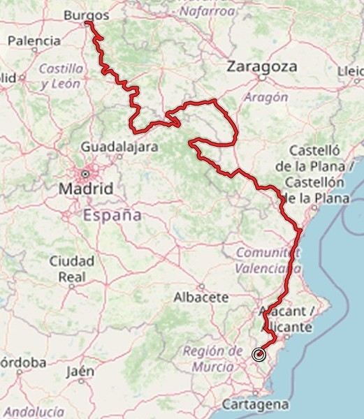
Hi there,
The full route from Burgos to (just before) Murcia is 1,300 km.
If you’ve done the whole thing, do you think the entire route is worth the trip, or can some sections be skipped?
Thanks.
The full route from Burgos to (just before) Murcia is 1,300 km.
If you’ve done the whole thing, do you think the entire route is worth the trip, or can some sections be skipped?
Thanks.
Hi there,
New to bike touring,
I’d love to start with a section of the Via Rhona to explore and share (route to be decided).
Looking forward to exchanging tips!
hi,
so glad the site’s open for discussion again...
I’m planning a trip on a recumbent bike. Has anyone here tried recumbents with e-assist? I went for this option because climbing mountains is tough without a boost—probably going with a mid-drive motor.
Also, anyone up for joining a stretch of the route heading toward Greece at the end of 2025?
welcome
Hi there.
I'd like to change the chainring on my Riverside 5 with trigger shifters.
I’m attaching a photo for advice. I’m lacking power and want a larger chainring for road use because I’m spinning out on the highest gear even though I still have power to give on flat terrain.
At Decathlon, they were supposed to get back to me after checking it out in the workshop but never did. It was outside their standards, and the salesperson clearly forgot about me...
What are your recommendations and suitable products for purchase, please?
Thanks.
Best regards,
Hi there,
I’m planning the route to cycle from Lille to Nordkapp with my partner.
Duration: 3 months, from May 1st to July 31st, 2026.
In the attached details below, I need to add some "non-riding" days (rest days, basically).
So I’m looking to "shorten" the trip by taking ferries or trains for some stretches. Which areas could I skip?
Thanks in advance for your great tips.
Have a good evening.
https://www.komoot.com/fr-fr/collection/4023980/-lille-cap-nord-1er-mai-au-31-juillet-2026?ref=collection
On the new OUIGO trains,
there’s now a bike space where you can hang your bike!
https://youtu.be/MfLUXBwrsKw?si=llghy79WExLfzPXR
https://youtu.be/MfLUXBwrsKw?si=llghy79WExLfzPXR
Hi there,
Just a few words about the loop I did by bike in Yunnan.
Entry and exit
I entered China through the Sino-Vietnamese border crossing at Lào Cai / Hekou under the 30-day visa exemption currently available to French nationals and others.
The process was simple and quick. A Chinese police officer even helped me complete my electronic pre-registration at a computer kiosk. I wasn’t aware this formality was required—it’s similar to Thailand’s TM6.
No issues with the bike.
I left the country via the Sino-Laotian border crossing at Mohan / Boten.
The atmosphere was a bit chaotic there, but again, no problems with the bike.
The timing
I visited Yunnan in February 2026.
Weather-wise, at higher altitudes (between 1,500 and 2,000 meters), it was around ten degrees at night and in the mornings, and around twenty degrees at the hottest part of the day.
I had two days of rain, so I took the bus to keep moving. Otherwise, clear blue skies.
Culturally, Chinese New Year fell on February 17th (and the 15 days following), right in the middle of my trip. Because of this, my take on the traffic might be off.
Accommodation and food I always found a hotel to stay in for prices ranging from 8 to 15 €. Except in Kunming (the capital), where many hotels were fully booked (Chinese New Year). I ended up at a 100 € hotel with great value for money.
A bowl of noodles costs about 1.5 € on average.
Onboard electronics Since my smartphone doesn’t support eSIMs, I subscribed to a China plan with my carrier. Otherwise, for much cheaper, Alipay offers eSIMs for foreigners that allow access to services usually blocked for Chinese users (WhatsApp, Facebook, etc.).
An internet connection is essential for paying with Alipay or WeChat, as this payment method is widespread.
I only managed to use Alipay.
Either way, always carry cash because sometimes there’s no signal, or the merchant only accepts WeChat.
Also, it’s best to bring a power adapter when you arrive rather than struggling to find one.
Traffic and roads The Chinese aren’t reckless drivers. They follow traffic rules and watch out for cyclists. This is slightly less true in Xishuangbanna (the region bordering Myanmar and Laos).
In urban areas, there are almost always wide bike lanes, separated from other roads, where bikes, electric mini-scooters, and scooters share the space pretty harmoniously.
The roads are in great condition, and traffic is generally manageable—even light—except for one stretch (Eshan -> Yangwu).
Most traffic is absorbed by expressways, China’s equivalent of highways: toll roads that are off-limits to slow vehicles.
You’re never far from these expressways; sometimes you even ride alongside them, which can be noisy at times.
The climbs are usually reasonable, around 5% to 6%. From what I remember, the steepest section was between Menglun and Mengla, with gradients of 8% to 10%, sometimes more.
Riding at these altitudes—though modest—took a bit of getting used to.
The route I didn’t plan anything in advance. My only goal was to reach Kunming. I don’t know why, but just hearing the name of that city, like Yunnan, always felt dreamy to me.
Here’s the breakdown: Hekou -> Man Hao (94 km); Man Hao -> Yuanyang (64 km); Yuanyang -> Jianshui (bus); Jianshui -> Tong Hai (78 km); Tong Hai -> Chenjiang (85 km); Chenjiang -> Kunming (60 km); Kunming -> Kunyang (60 km); Kunyang -> Eshan (67 km); Eshan -> Yangwu (58 km); Yangwu -> Yuanjiang (59 km); Yuanjiang -> Pu'er (bus); Pu'er -> Dadugang (75 km); Dadugang -> Jinghong (80 km); Jinghong -> Menglun (67 km); Menglun -> Mengyuancun (51 km); Mengyuancun -> Mengla (43 km); Mengla -> Boten (67 km).
Otherwise, I’m currently in Thailand and just hoping my return flight with Qatar won’t get canceled.
Oh well... 😉
Hi everyone, I’m new to the forum!
I’d like to buy some panniers for bike travel made of Cordura. I initially went for the Ortlieb Back Roller Plus, but while browsing the cylo-randonnée website, I came across the Extrawheel Wayfarer Premium panniers. They’re also made of Cordura, manufactured in Poland with German materials, and each has a 25-liter capacity—10 liters more than the Ortliebs.
Has anyone here tried them or knows this brand? I know Ortlieb is super reputable, but I figured there might be other brands that are just as good.
🙂 Gabriele
A firsthand account of a 30-day cycling trip (the length of the visa) in southern Vietnam, from Hue to the Mekong Delta. 1,500 kilometers pedaled in December 2022 and January 2023.
Roads and Traffic The roads are generally in very good condition. The secondary road network is limited. Since Vietnam is a densely populated country, needless to say, traffic is often heavy, including on secondary roads. Cyclists, along with pedestrians, are at the very bottom of the road-user hierarchy. In short, when you're on a bike, you never have the right of way. The atmosphere is deafening—Vietnamese people honk all the time. For a Western ear, it's hard to tell the difference between a honk that just signals someone's presence, one that warns of imminent danger, or an angry honk. 😏
Weather Vietnam is a long, narrow country (1,600 km). The weather isn’t the same in the north, center, or south. I cycled through the central part in December. Even though the monsoon peak had passed, I still encountered a lot of rain. Since the monsoon usually lasts until January, it might be better to cycle there starting in February. I was in the Mekong Delta in January. The best season, as it’s the driest month with the least hot temperatures. At this time of year, the prevailing winds come from the northeast. So, it’s better to travel from north to south. That way, you’ll usually have the wind at your back.
Accommodation I always stayed in hotels without ever booking in advance. Typically, I paid between 10 and 20 € for a double room with a private bathroom and AC. To find hotels, I used Google Maps and Maps.me. Wi-Fi is available for free almost everywhere.
The Route Hue → Danang → Hoi An → Nha Trang → Phan Rang → Tan Son → Dalat → Di Linh → Mui Ne → La Gi → Vung Tau → Nha Be → My Tho → Tra Vinh → Can Tho → Cao Lanh → Tranh Hoa → Trang Bang I took the train from Danang to Nha Trang. Not all trains accept bikes, so you’ll need to check beforehand. The railway handles bikes—they’re packed by staff and travel in the same train but in a freight car. I paid 14 € for the ticket plus 7 € for the bike (there’s an extra 0.50 € to pay upon arrival).
The Verdict So, is cycling in Vietnam worth it? If you enjoy biking in traffic, then yes. Otherwise... 😎