Discussions started by Marcalamar
About 185 results.
More options
Many results are in French, the community’s main language. English translations are added over time.
Search results
Which entrance to choose for Pinnacles National Park (California): East or West?
Hi everyone! 🙂
I’m almost done planning our September road trip. After our 3-night visit to Sequoia, we’ll have a stopover night in Coalinga (to break up the drive). We’ll be staying two nights in Monterey and would like to stop along the way to visit one side of Pinnacles National Park. We’re torn between the West entrance and the East entrance, and we’d like to do a short hike of no more than 2 hours since we don’t want to arrive too late in Monterey.
This park is split into two distinct zones with no connection between them, and the mileage from Coalinga to Monterey is pretty much the same for both. Which area do you recommend visiting—east or west? And which route is the most scenic?
I’ve spotted two short hikes: - East: Moses Spring to Rim Trail Loop - West: Balconies Cliffs Cave Loop
Has anyone been there, or do you have another hike to suggest?
Thanks in advance, and have a great afternoon! Marcalamar 🙂
I’m almost done planning our September road trip. After our 3-night visit to Sequoia, we’ll have a stopover night in Coalinga (to break up the drive). We’ll be staying two nights in Monterey and would like to stop along the way to visit one side of Pinnacles National Park. We’re torn between the West entrance and the East entrance, and we’d like to do a short hike of no more than 2 hours since we don’t want to arrive too late in Monterey.
This park is split into two distinct zones with no connection between them, and the mileage from Coalinga to Monterey is pretty much the same for both. Which area do you recommend visiting—east or west? And which route is the most scenic?
I’ve spotted two short hikes: - East: Moses Spring to Rim Trail Loop - West: Balconies Cliffs Cave Loop
Has anyone been there, or do you have another hike to suggest?
Thanks in advance, and have a great afternoon! Marcalamar 🙂
Planning King Canyon and Sequoia National Park
Hi everyone! 🙂
Just a quick question about King Canyon and Sequoia National Park.
Before our night in Miramonte, we plan to visit King Canyon. The next stop will be two nights in Three Rivers to explore Sequoia National Park. I wanted to go all the way to Roaring River Falls on the King Canyon Scenic Byway and then turn back to head to Miramonte. Since we’re coming from Oakhurst, Google Maps says it’s 300 km and 5 hours of driving. Since we also want to hike to see the sequoias (Big Stump Area and Grand Grove) before tackling the King Canyon Scenic Byway, the timing’s going to be tight. How far do you recommend going before turning back to miss as few points of interest as possible on the King Canyon Scenic Byway? Thanks for your advice, and have a great evening!
Marcalamar 🙂
Parking and Viewpoints for Lake Tahoe Visits
Good evening, everyone! 🙂
Just a few last questions to wrap up our Lake Tahoe visit plans.
**Parking:** We’d like to walk to Eagle Falls and then Eagle Lake. I’ve spotted two parking lots that seem close to each other and give access to the trailhead. Where and how do we pay for entry to Emerald Bay State Park and Inspiration Point?
**Viewpoints on the East Side:** Are most of the viewpoints (Balancing Rock, Granite Cave, Bonsai Rock, etc.) right by the road, or do you have to hike to reach them?
**Donner Memorial State Park:** Is it worth making a detour to Truckee to visit this park and the Truckee historic downtown?
Thanks in advance for your tips! 🙂
**Parking:** We’d like to walk to Eagle Falls and then Eagle Lake. I’ve spotted two parking lots that seem close to each other and give access to the trailhead. Where and how do we pay for entry to Emerald Bay State Park and Inspiration Point?
**Viewpoints on the East Side:** Are most of the viewpoints (Balancing Rock, Granite Cave, Bonsai Rock, etc.) right by the road, or do you have to hike to reach them?
**Donner Memorial State Park:** Is it worth making a detour to Truckee to visit this park and the Truckee historic downtown?
Thanks in advance for your tips! 🙂
Questions about SUV trails and must-sees for a California road trip
Hi everyone! 🙂
As you can see, we're heading back from September 6th to the 27th.
Everything’s booked for September—flights, accommodations, and the car. As I plan, I’ll be asking the experts for help. This is our second trip to California, but most of the stops are new to us.
We’ll start directly from San Francisco to our first overnight stop, Davis, before heading to Lassen Volcanic Park for 4 nights. Our flight lands at 12:50 PM.
Here’s our itinerary: Day 1: Davis – overnight stop Day 2: Red Bluff – exploring Lassen Volcanic Park (scenic drive to Lake Helen) Day 3: Susanville – scenic drive through the park via the South Entrance, points of interest, and hikes Day 4: Susanville – Cinder Cone and Painted Dunes hike Day 5: Susanville – Warner Valley (hikes) Day 6: South Lake Tahoe Day 7: South Lake Tahoe Day 8: Mammoth Lake Day 9: Mammoth Lake Day 10: El Portal via Tioga Road Day 11: El Portal Day 12: El Portal Day 13: Oakhurst Day 14: Miramonte Day 15: Three Rivers Day 16: Three Rivers Day 17: Coalinga Day 18: Monterey Day 19: Monterey Day 20: San Francisco Day 21: San Francisco Day 22: Departure
For hikes in Lassen Volcanic Park, I’ve planned: Bumpass Hell, Cold Boiling Lake (Day 2) Paradise Meadow (maybe not going all the way), Devastated Area, and the loop around Reflection and Manzanita Lakes (Day 3) Cinder Cone and Painted Dunes (Day 4) Devil’s Kitchen and Boiling Spring Lake (Day 5)
I’ve read there are trails to access the trailheads for Cinder Cone (11 km) and Warner Valley. Are these easy trails for an SUV? Are there any other must-see spots or things we shouldn’t miss?
That’s where I’m at for now. Thanks for your replies, and have a great evening! Marcalamar 🙂
Here’s our itinerary: Day 1: Davis – overnight stop Day 2: Red Bluff – exploring Lassen Volcanic Park (scenic drive to Lake Helen) Day 3: Susanville – scenic drive through the park via the South Entrance, points of interest, and hikes Day 4: Susanville – Cinder Cone and Painted Dunes hike Day 5: Susanville – Warner Valley (hikes) Day 6: South Lake Tahoe Day 7: South Lake Tahoe Day 8: Mammoth Lake Day 9: Mammoth Lake Day 10: El Portal via Tioga Road Day 11: El Portal Day 12: El Portal Day 13: Oakhurst Day 14: Miramonte Day 15: Three Rivers Day 16: Three Rivers Day 17: Coalinga Day 18: Monterey Day 19: Monterey Day 20: San Francisco Day 21: San Francisco Day 22: Departure
For hikes in Lassen Volcanic Park, I’ve planned: Bumpass Hell, Cold Boiling Lake (Day 2) Paradise Meadow (maybe not going all the way), Devastated Area, and the loop around Reflection and Manzanita Lakes (Day 3) Cinder Cone and Painted Dunes (Day 4) Devil’s Kitchen and Boiling Spring Lake (Day 5)
I’ve read there are trails to access the trailheads for Cinder Cone (11 km) and Warner Valley. Are these easy trails for an SUV? Are there any other must-see spots or things we shouldn’t miss?
That’s where I’m at for now. Thanks for your replies, and have a great evening! Marcalamar 🙂
Martine from DD in Arizona and New Mexico
Good evening everyone! 🙂
We’re back from our September 2025 road trip, this time to explore Arizona and New Mexico, and it’s time for me to start my travel journal—especially since everything’s already booked for another trip in September 2026 (to California), and I need to get started on the planning.
I was a little worried this new visit to Uncle Sam’s country might not be as "wow" as the others, but we still discovered some incredible places.
For those who don’t know us, we’re a couple in our seventies who speak very little English, but that didn’t stop us from fully enjoying our stay.
For this 6th road trip in the U.S., we spent 21 nights there, drove 4,160 km by car, and walked nearly 160 km in a loop starting from Phoenix.
We’d been to Arizona before (but not this side) and never to New Mexico. This whole road trip was a huge discovery for us.
In the prices mentioned (some in euros, others in dollars), bank fees and exchange charges are included. The flights, car rental, and parking were all paid for in December 2024 when we booked.
We’d downloaded the MPC (Mobile Passport Control) app, but there wasn’t a dedicated line at Phoenix Airport. Still, we got through quickly with friendly, smiling agents.
I don’t drive at all (I hate it), so the stops were chosen based on activities but also, for some, to limit daily mileage for the sole driver. The kilometers listed in the itinerary are the daily distances.
We traveled from September 9th to 22nd, unfortunately once again without our dear friends Mimi and Maumau.
The itinerary
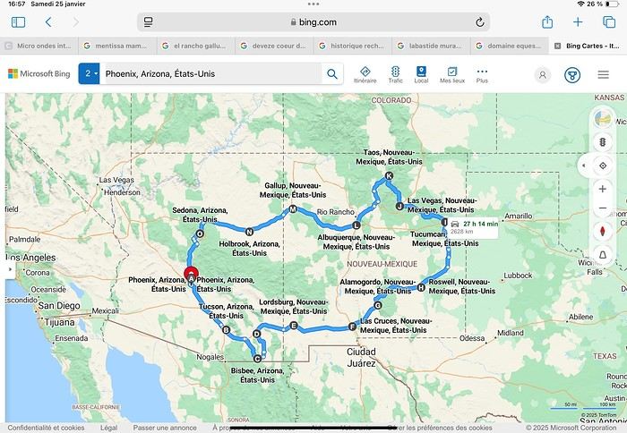
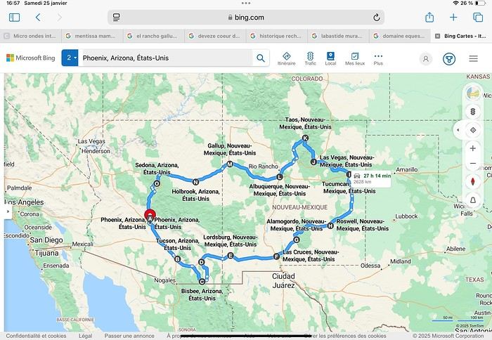
Day 1: Flight Marseille-Paris-Phoenix, then Gold Canyon (133 km) Day 2: Tucson (271 km) Lost Dutchman State Park Day 3: Tucson (155 km) Day 4: Tucson (34 km) Day 5: Bisbee (182 km) Day 6: Lordsburg (345 km) Day 7: Las Cruces (253 km) Day 8: Alamogordo (162 km) Day 9: Roswell (264 km) Day 10: Tucumcari (369 km) Day 11: Las Vegas (281 km) – the one in New Mexico Day 12: Taos (213 km) Day 13: Santa Fe (224 km) Day 14: Albuquerque (123 km) Day 15: Gallup (246 km) Day 16: Holbrook (224 km) Day 17: Flagstaff (179 km) Day 18: Sedona (118 km) Day 19: Sedona (48 km) Day 20: Sedona (41 km) Day 21: Phoenix (256 km) Day 22: Phoenix Airport (35 km)
📊 **Budget**: A little over 7,500 € for both of us, all included. The exchange rate was in our favor (1.17 dollars to 1 €). 📊 **Flights**: Marseille-Paris Charles de Gaulle-Phoenix: 1,787 € for two, with one checked bag each (Air France) 📊 **ESTA**: $42 📊 **America the Beautiful Pass**: $80 📊 **Parking**: 134 € (super eco at Marseille) 📊 **Car rental (Hertz)**: 865 €. Since there were no SUVs left in the reserved category (Nissan Rogue), we got an upgrade (4x4 Ford Explorer). We booked through Air France (15% discount). We’d originally reserved it in December for 1,140 €, but since prices dropped in March, we canceled and rebooked for 865 €. Hertz offers a free Hertz Gold Plus Rewards program, which gives you priority counter service when picking up the car. 📊 **Accommodation**: 2,400 € We stayed in hotels and motels of varying standards (from 60 to 203 € per night, depending on the city), all booked through Booking.com or Hotels.com. Out of 21 nights, only two didn’t include breakfast in the price. Booking.com sometimes offers slightly cheaper rates if you book by phone using the mobile app, and our Genius 3 status on the site also got us some preferential rates. 📊 **Supplementary insurance**: AVA 200 € for medical care if needed 📊 **Cash**: $2,078. We left with 1,000 € exchanged before departure and made two withdrawals of $500. This cash covered: - Evening restaurants and tips - Midday picnics - Gas: $298 for 4,160 km - Museum and private park entries (per person): - Lost Dutchman: $10 - Arizona-Sonora Desert Museum: $28 - Bird Cage Theater: $16 - Tombstone Shootout: $8 - New Mexico Farm & Ranch Museum: $12 - Roswell International UFO Museum: $5 - Billy the Kid Museum: $7 - Rancho de Taos: $22 - West Fork Oak Creek Trail entry: $15 We got a few discounts thanks to our senior age (+65). - Souvenirs and little treats
Like on our previous road trips, we didn’t rent a GPS. We got around using offline GPS apps Here WeGo and Organic Maps, with maps of the states we visited downloaded before we left (on our phones).
❤️❤️❤️ **Highlights** (there are so many!) 📍 Goldfield Ghost Town (even if it’s a reconstruction) 📍 The standing army of Saguaro cacti at Saguaro National Park West 📍 Diving into the cowboy universe of Tombstone 📍 The welcome from Rick and Henry at our guesthouse in Bisbee (Garden at Mile High Ranch) 📍 The tangled rocks of Chiricahua National Monument 📍 The flavored pistachios from Dwayne’s Fresh Jerky and Mac Ginnis Pistachioland 📍 Restaurants: La Posta (Las Cruces), Diner 66 (Albuquerque), and the Haunted Hamburger (Jerome) 📍 The old plazas of New Mexico 📍 The solitude and beauty of the white dunes at White Sands National Park 📍 Stepping back in time at the Billy the Kid Museum (Fort Stanton) 📍 Sections of historic Route 66 and the old motels of Tucumcari, especially at night when all the neon lights are on 📍 Taos Pueblo and diving into Native American culture 📍 After the Rio Grande Bridge, the descent via NM 567 to the very bottom of the Rio Grande Gorge, then the road along the riverbanks to Taos 📍 The tranquility of the Chimayo Sanctuary 📍 Discovering the ingenious native dwellings at Bandelier National Monument and Walnut Canyon National Park 📍 The small towns along the Turquoise Trail 📍 The red rocks of Red Rock Park and the Painted Desert 📍 The extraordinary colors of the petrified trees at Petrified Forest National Park 📍 Sedona, its red rocks, and the reward of the viewpoints at the end of hikes (Devil’s Bridge, The Subway, and West Fork Oak Creek) 📍 The immersion in Mexico when visiting Tlaquepaque 📍 The almost-ghost town of Jerome and its terraced streets 📍 The incredible kindness of Americans, always ready to help and up for a chat ❤️
☹️☹️☹️ **Flops** (there are very few) 📍 Several museums and churches being closed, so we couldn’t visit them 📍 Some museums and visitor centers opening late (10 AM) and closing early (4 PM) 📍 A 64 € phone roaming charge because we got near the Mexican border and picked up their cell tower 📍 The outrageous price ($5.99) for a gallon of gas at the Shell near Phoenix Airport
I hope this helps! Anyway, thanks for reading my long post. Don’t hesitate to reach out, even via PM, if you see I haven’t replied and you’d like more details. Have a great evening, everyone! 🙂
We’re back from our September 2025 road trip, this time to explore Arizona and New Mexico, and it’s time for me to start my travel journal—especially since everything’s already booked for another trip in September 2026 (to California), and I need to get started on the planning.
I was a little worried this new visit to Uncle Sam’s country might not be as "wow" as the others, but we still discovered some incredible places.
For those who don’t know us, we’re a couple in our seventies who speak very little English, but that didn’t stop us from fully enjoying our stay.
For this 6th road trip in the U.S., we spent 21 nights there, drove 4,160 km by car, and walked nearly 160 km in a loop starting from Phoenix.
We’d been to Arizona before (but not this side) and never to New Mexico. This whole road trip was a huge discovery for us.
In the prices mentioned (some in euros, others in dollars), bank fees and exchange charges are included. The flights, car rental, and parking were all paid for in December 2024 when we booked.
We’d downloaded the MPC (Mobile Passport Control) app, but there wasn’t a dedicated line at Phoenix Airport. Still, we got through quickly with friendly, smiling agents.
I don’t drive at all (I hate it), so the stops were chosen based on activities but also, for some, to limit daily mileage for the sole driver. The kilometers listed in the itinerary are the daily distances.
We traveled from September 9th to 22nd, unfortunately once again without our dear friends Mimi and Maumau.
The itinerary
Day 1: Flight Marseille-Paris-Phoenix, then Gold Canyon (133 km) Day 2: Tucson (271 km) Lost Dutchman State Park Day 3: Tucson (155 km) Day 4: Tucson (34 km) Day 5: Bisbee (182 km) Day 6: Lordsburg (345 km) Day 7: Las Cruces (253 km) Day 8: Alamogordo (162 km) Day 9: Roswell (264 km) Day 10: Tucumcari (369 km) Day 11: Las Vegas (281 km) – the one in New Mexico Day 12: Taos (213 km) Day 13: Santa Fe (224 km) Day 14: Albuquerque (123 km) Day 15: Gallup (246 km) Day 16: Holbrook (224 km) Day 17: Flagstaff (179 km) Day 18: Sedona (118 km) Day 19: Sedona (48 km) Day 20: Sedona (41 km) Day 21: Phoenix (256 km) Day 22: Phoenix Airport (35 km)
📊 **Budget**: A little over 7,500 € for both of us, all included. The exchange rate was in our favor (1.17 dollars to 1 €). 📊 **Flights**: Marseille-Paris Charles de Gaulle-Phoenix: 1,787 € for two, with one checked bag each (Air France) 📊 **ESTA**: $42 📊 **America the Beautiful Pass**: $80 📊 **Parking**: 134 € (super eco at Marseille) 📊 **Car rental (Hertz)**: 865 €. Since there were no SUVs left in the reserved category (Nissan Rogue), we got an upgrade (4x4 Ford Explorer). We booked through Air France (15% discount). We’d originally reserved it in December for 1,140 €, but since prices dropped in March, we canceled and rebooked for 865 €. Hertz offers a free Hertz Gold Plus Rewards program, which gives you priority counter service when picking up the car. 📊 **Accommodation**: 2,400 € We stayed in hotels and motels of varying standards (from 60 to 203 € per night, depending on the city), all booked through Booking.com or Hotels.com. Out of 21 nights, only two didn’t include breakfast in the price. Booking.com sometimes offers slightly cheaper rates if you book by phone using the mobile app, and our Genius 3 status on the site also got us some preferential rates. 📊 **Supplementary insurance**: AVA 200 € for medical care if needed 📊 **Cash**: $2,078. We left with 1,000 € exchanged before departure and made two withdrawals of $500. This cash covered: - Evening restaurants and tips - Midday picnics - Gas: $298 for 4,160 km - Museum and private park entries (per person): - Lost Dutchman: $10 - Arizona-Sonora Desert Museum: $28 - Bird Cage Theater: $16 - Tombstone Shootout: $8 - New Mexico Farm & Ranch Museum: $12 - Roswell International UFO Museum: $5 - Billy the Kid Museum: $7 - Rancho de Taos: $22 - West Fork Oak Creek Trail entry: $15 We got a few discounts thanks to our senior age (+65). - Souvenirs and little treats
Like on our previous road trips, we didn’t rent a GPS. We got around using offline GPS apps Here WeGo and Organic Maps, with maps of the states we visited downloaded before we left (on our phones).
❤️❤️❤️ **Highlights** (there are so many!) 📍 Goldfield Ghost Town (even if it’s a reconstruction) 📍 The standing army of Saguaro cacti at Saguaro National Park West 📍 Diving into the cowboy universe of Tombstone 📍 The welcome from Rick and Henry at our guesthouse in Bisbee (Garden at Mile High Ranch) 📍 The tangled rocks of Chiricahua National Monument 📍 The flavored pistachios from Dwayne’s Fresh Jerky and Mac Ginnis Pistachioland 📍 Restaurants: La Posta (Las Cruces), Diner 66 (Albuquerque), and the Haunted Hamburger (Jerome) 📍 The old plazas of New Mexico 📍 The solitude and beauty of the white dunes at White Sands National Park 📍 Stepping back in time at the Billy the Kid Museum (Fort Stanton) 📍 Sections of historic Route 66 and the old motels of Tucumcari, especially at night when all the neon lights are on 📍 Taos Pueblo and diving into Native American culture 📍 After the Rio Grande Bridge, the descent via NM 567 to the very bottom of the Rio Grande Gorge, then the road along the riverbanks to Taos 📍 The tranquility of the Chimayo Sanctuary 📍 Discovering the ingenious native dwellings at Bandelier National Monument and Walnut Canyon National Park 📍 The small towns along the Turquoise Trail 📍 The red rocks of Red Rock Park and the Painted Desert 📍 The extraordinary colors of the petrified trees at Petrified Forest National Park 📍 Sedona, its red rocks, and the reward of the viewpoints at the end of hikes (Devil’s Bridge, The Subway, and West Fork Oak Creek) 📍 The immersion in Mexico when visiting Tlaquepaque 📍 The almost-ghost town of Jerome and its terraced streets 📍 The incredible kindness of Americans, always ready to help and up for a chat ❤️
☹️☹️☹️ **Flops** (there are very few) 📍 Several museums and churches being closed, so we couldn’t visit them 📍 Some museums and visitor centers opening late (10 AM) and closing early (4 PM) 📍 A 64 € phone roaming charge because we got near the Mexican border and picked up their cell tower 📍 The outrageous price ($5.99) for a gallon of gas at the Shell near Phoenix Airport
I hope this helps! Anyway, thanks for reading my long post. Don’t hesitate to reach out, even via PM, if you see I haven’t replied and you’d like more details. Have a great evening, everyone! 🙂
Hiking passes for Red Rock State Park in Sedona
Hi everyone! 🙂
A little request for help from those who’ve stayed in Sedona—we’ll have almost 3 full days there. I’ve done some research on different sites, but I’m still confused.
It seems that some spots require, in addition to the America the Beautiful Pass (which we’ll already have from the start of our road trip), the Red Rock Day Pass since they’re within Red Rock State Park. This would be for park and parking lot maintenance.
Here are the hikes we’re eyeing: Boynton Canyon, Devil’s Bridge, Birthday Cave, Airport Mesa, Chapel of the Holy Cross, Cathedral Rock, Bell Rock, and Crescent Moon Ranch.
We won’t be able to do all of them—we’ll have to choose 🤔 and cut some 😢.
On top of that, there are the two scenic drives: Red Rock Scenic Byway and Oak Creek Scenic Drive.
Does the America the Beautiful Pass cover everything, or do we also need the Red Rock Day Pass? And if we do, which hikes require it?
Thanks for your answers, and have a great afternoon! marcalamar 🙂
A little request for help from those who’ve stayed in Sedona—we’ll have almost 3 full days there. I’ve done some research on different sites, but I’m still confused.
It seems that some spots require, in addition to the America the Beautiful Pass (which we’ll already have from the start of our road trip), the Red Rock Day Pass since they’re within Red Rock State Park. This would be for park and parking lot maintenance.
Here are the hikes we’re eyeing: Boynton Canyon, Devil’s Bridge, Birthday Cave, Airport Mesa, Chapel of the Holy Cross, Cathedral Rock, Bell Rock, and Crescent Moon Ranch.
We won’t be able to do all of them—we’ll have to choose 🤔 and cut some 😢.
On top of that, there are the two scenic drives: Red Rock Scenic Byway and Oak Creek Scenic Drive.
Does the America the Beautiful Pass cover everything, or do we also need the Red Rock Day Pass? And if we do, which hikes require it?
Thanks for your answers, and have a great afternoon! marcalamar 🙂
Red Rock Park New Mexico
Hi there! 😊
- About fifteen kilometers from Gallup, where we’re stopping, there’s a small state park: Red Rock Park.
Two hikes are catching my eye:
Pyramid Rock Trail (229 m elevation gain, 5.5 km, 1h45)
Church Rock Trail (78 m elevation gain, 3.5 km, 1 hour)
Has anyone been there? And if so, which one would you recommend?
Thanks for your replies and have a great rest of your afternoon!
Marcalamar :)
Which route to choose for Taos to Albuquerque?
Hi everyone,
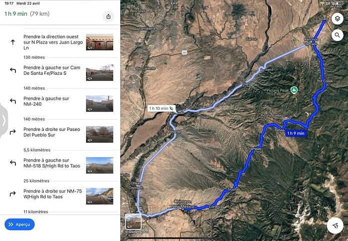
For our leg from Taos to Albuquerque, we have two options with roughly the same mileage and driving time:
Either the light blue route (NM 518 then NM 76)
or the dark blue route (NM 68), which would let us visit the Embudo Gas Museum.
We’d love to stop at the Chimayó Sanctuary if it’s worth the small detour.
We’ll have already taken NM 518 from Las Vegas to Taos.
Which route is prettier and has the most points of interest?
Afterward, we’ll take the Turquoise Trail between Santa Fe and Albuquerque.
Thanks for your input!
Marcalamar :)
Roswell to Tucumcari leg: Route 66 conditions
Hi everyone! 🙂
We’re on the Roswell–Tucumcari leg. We’ll go through Fort Sumner. After visiting, there are two ways to reach Tucumcari:
Take US 84 to Santa Rosa, see its Blue Hole, then the almost ghost towns on the historic Route 66 (Cuervo, Newkirk, and Montoya). We won’t visit the Route 66 auto museum (we’ll do the one in Tucumcari). The other option is to take 252 and then 209.
The next day, we plan to head to our next stop in Las Vegas (the one in NM) by going up the Mesalands Scenic Byway (104).
Is the detour to Santa Rosa worth it? Are the historic Route 66 sections drivable?
Thanks for your tips! Marcalamar 🙂
We’re on the Roswell–Tucumcari leg. We’ll go through Fort Sumner. After visiting, there are two ways to reach Tucumcari:
Take US 84 to Santa Rosa, see its Blue Hole, then the almost ghost towns on the historic Route 66 (Cuervo, Newkirk, and Montoya). We won’t visit the Route 66 auto museum (we’ll do the one in Tucumcari). The other option is to take 252 and then 209.
The next day, we plan to head to our next stop in Las Vegas (the one in NM) by going up the Mesalands Scenic Byway (104).
Is the detour to Santa Rosa worth it? Are the historic Route 66 sections drivable?
Thanks for your tips! Marcalamar 🙂
Looking for Parking in Tombstone (USA)
Hi there! 🙂
I'm taking it slow—I'm only on day 5 of my Tucson to Bisbee leg.
We'd like to stop in Tombstone along the way. I've spotted Boot Hill Cemetery, the Tombstone Courthouse State Historic Park, and around the visitor center: the O.K. Corral, Tombstone Historama, the Tombstone Epitaph, the Bird Cage Theatre, and the Crystal Palace Saloon. Is everything worth visiting, and is parking easy in Tombstone? If anyone has parking recommendations, I'd love to hear them. Thanks in advance!
As for Bisbee, I've noted the Queen Mine Tour, the Great Bisbee Stairs Climb, and the downtown tour. Outside of town, there's the Lavender Pit. Any other suggestions for things to check out?
Thanks so much! Marcalamar 🙂
I'm taking it slow—I'm only on day 5 of my Tucson to Bisbee leg.
We'd like to stop in Tombstone along the way. I've spotted Boot Hill Cemetery, the Tombstone Courthouse State Historic Park, and around the visitor center: the O.K. Corral, Tombstone Historama, the Tombstone Epitaph, the Bird Cage Theatre, and the Crystal Palace Saloon. Is everything worth visiting, and is parking easy in Tombstone? If anyone has parking recommendations, I'd love to hear them. Thanks in advance!
As for Bisbee, I've noted the Queen Mine Tour, the Great Bisbee Stairs Climb, and the downtown tour. Outside of town, there's the Lavender Pit. Any other suggestions for things to check out?
Thanks so much! Marcalamar 🙂
Sabino Canyon
Hi everyone! 🙂
Since my 2024 travel journal is finally posted, I’m diving into planning our September road trip to the part of Arizona we haven’t explored yet and to New Mexico, which we don’t know at all.
Flights, accommodations, and the rental car are all set—I just need to organize the stops. On the day we arrive in Phoenix (we’re staying in Gold Canyon), I’ve planned a visit to Lost Dutchman State Park at sunset with a short hike and a stop at Goldfield Ghost Town. I was thinking of driving as far as Tortilla Flat, but it might be tight, especially since our flight lands at 12:50 PM, and the most scenic part of the Apache Trail seems to be just past Tortilla Flat. The next day, we’re heading to Tucson for three nights. The first day will be dedicated to Saguaro East (near our hotel), the following day to the Arizona-Sonora Desert Museum, then the Bajada Loop Drive with two short hikes, and the North Kidney Road up to the OVL. Finally, on the last day, we’ll visit Sabino Canyon and hike to Seven Falls—and this is where I could use your insights! The hike is 13 km if we don’t take the shuttle. If we do, it’s only 8 km. Are those kilometers flat, or does it climb right from the start? And if we take the shuttle, where should we get off? Is the trail well-marked? I’ve heard it’s not very clearly signposted.
Thanks in advance for your tips, and I’ll be back with more questions soon! Marcalamar 🙂
Since my 2024 travel journal is finally posted, I’m diving into planning our September road trip to the part of Arizona we haven’t explored yet and to New Mexico, which we don’t know at all.
Flights, accommodations, and the rental car are all set—I just need to organize the stops. On the day we arrive in Phoenix (we’re staying in Gold Canyon), I’ve planned a visit to Lost Dutchman State Park at sunset with a short hike and a stop at Goldfield Ghost Town. I was thinking of driving as far as Tortilla Flat, but it might be tight, especially since our flight lands at 12:50 PM, and the most scenic part of the Apache Trail seems to be just past Tortilla Flat. The next day, we’re heading to Tucson for three nights. The first day will be dedicated to Saguaro East (near our hotel), the following day to the Arizona-Sonora Desert Museum, then the Bajada Loop Drive with two short hikes, and the North Kidney Road up to the OVL. Finally, on the last day, we’ll visit Sabino Canyon and hike to Seven Falls—and this is where I could use your insights! The hike is 13 km if we don’t take the shuttle. If we do, it’s only 8 km. Are those kilometers flat, or does it climb right from the start? And if we take the shuttle, where should we get off? Is the trail well-marked? I’ve heard it’s not very clearly signposted.
Thanks in advance for your tips, and I’ll be back with more questions soon! Marcalamar 🙂
Martine and DD in Colorado and Utah
Hello everyone! 🙂
So many silent months, and now Voyage Forum is accessible again. That’s cool because we can pick up our discussions for our mutual enjoyment.
I hope everyone is doing well and that you’ve been able to take some great trips, whether to the USA or elsewhere.
In September 2020, we had planned a round trip to explore Colorado, but unfortunately, a nasty virus messed up our plans, closing borders and keeping us stuck at home. Luckily for us, canceling the car, flights, and accommodations didn’t cost us a thing—everything was refunded.
In 2023, a loop from Las Vegas let us revisit places we’d seen in 2017 and discover new ones, this time spending more time at each stop with some lovely hikes.
In 2024, we finally revisited the 2020 plan, and I’ll start with that.
However, unforeseen circumstances mean I have much less time than before, so I’ll keep my trip reports shorter (ha ha ha—you’ll have less of my prose to endure).
Another change: for those who remember the "Gang of Four crazy sixty-somethings," it was just DD and me this time. Our dear Mimi and Maumau left the Var to focus on raising horses and can’t leave their little green paradise to join us anymore. We were unfortunately much tamer without them.
We traveled from September 11 to October 3.
The itinerary
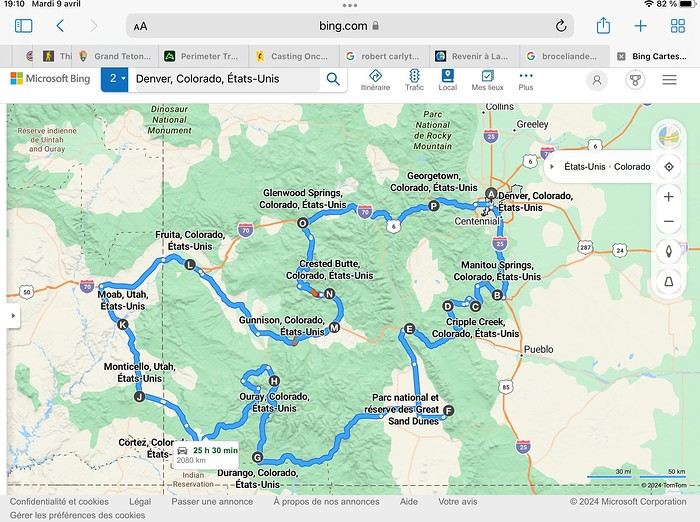
Day 1: Flight Marseille-Paris-Denver, then Manitou Springs (133 km) Day 2: Manitou Springs (49 km) Day 3: Cripple Creek (104 km) Day 4: Salida (254 km) Day 5: Great Sand Dunes (231 km) Day 6: Durango (283 km) Day 7: Durango (Durango-Silverton train) Day 8: Ouray (121 km) Day 9: Ouray (Perimeter Trail hike) Day 10: Cortez (213 km) Day 11: Cortez (Mesa Verde National Park, 134 km) Day 12: Monticello (268 km, detour to Chesler Park) Day 13: Moab (171 km, Delicate Arch) Day 14: Moab (98 km, Fisher Towers) Day 15: Moab (171 km, Canyonlands) Day 16: Fruita (210 km, Colorado National Monument) Day 17: Crested Butte (224 km via Kebler Pass) Day 18: Crested Butte (57 km) Day 19: Glenwood Springs (150 km) Day 20: Glenwood Springs (118 km, Rifle State Park) Day 21: Georgetown (258 km via Independence Pass) Day 22: Denver (123 km), then return flight
We speak very little English. We spent 21 nights there and covered a 3,400 km loop by car and 160 km on foot (we’re still trying to hike while we’re in shape) from Denver in September 2024. We wanted this road trip to help us explore Colorado a bit more—we’d only spent 6 nights there in 2019—and to see it during the fall foliage season. We also wanted to return to Utah (we love Moab) to enjoy its red rocks, which we adore.
In the prices you see (some in euros, others in dollars), I’ve included bank fees and exchange charges. The flights, car, and parking were paid by credit card when we booked in February. Usually, we book around November, but some obligations kept us from doing it earlier. We downloaded the MPC (Mobile Passport Control) app on our phone, which saved us time at immigration.
📊 **Budget: just under 8,500 € for both of us, all included**
📊 **Flights** Marseille-Paris (CDG)-Denver: 2,152 € for both of us, with one checked bag each
📊 **ESTA and America the Beautiful Pass** The ones from our 2023 road trip were still valid
📊 **Parking at Marseille airport: 122 €**
📊 **Car: Nissan Rogue (the French X-Trail) from Hertz: 1,165 €** By booking through Air France (and earning miles), we got a 15% discount. Hertz offers a free Hertz Gold Plus Rewards program, which gives us priority counter service.
📊 **Accommodation: 3,050 €** We stayed in motels and hotels of various ranges (from 100 € to 270 € per night, depending on the city), all booked through Hotels.com or Booking. Booking sometimes offers cheaper rates if you book via the "Booking mobile" app. We also got some preferential rates thanks to our Genius 2 status. Out of 21 nights, only one place didn’t include breakfast.
📊 **Other expenses (activities booked by credit card before leaving)** Durango-Silverton train: 210 € (we booked the enclosed vintage coach in March) Mesa Verde: Balcony House: 15.15 € (booked 14 days before the visit) Timed-entry passes for Arches National Park: 6 € for 3 days (booked June 1 for September entries via http://récreation.gov/). We booked three different days to play with the weather.
📊 **Supplementary insurance with AVA: 204 €** (due to our age 😅 and the high cost of medical consultations in the USA)
📊 **Cash: 1,540 €** We left with 1,000 € exchanged before departure and made two withdrawals (500 $ and 200 $). This cash was used to pay for: - Evening restaurants and tips (between 70 $ and 95 $ for two meals and two drinks) - Two state parks: Dead Horse State Park (20 $) and Rifle State Park (10 $) - The Monarch Pass gondola (24 $) - Midday picnics - Gas (slightly cheaper with cash): 204 $ for 3,400 km - Personal souvenirs and little treats.
Like in our previous road trips, we didn’t rent a GPS. We used the offline GPS app Here We Go, for which we’d downloaded maps of Colorado and Utah from France, as well as a new offline app called Organic Maps as a backup—though we didn’t end up needing it.
❤️❤️❤️ **Highlights (there are so many!)** 📍 The stunning landscapes of Colorado, especially with the fall colors 📍 A step back in time at the old farm in Florissant Fossil Beds National Monument 📍 The prairies of Cripple Creek and the mining remnants of the Vindicator Trail 📍 The cheeky chipmunks in the ghost town of St. Elmo 📍 Great Sand Dunes and its soft sand 📍 The steam train between Durango and Silverton: we’re glad we chose the round-trip because it rained heavily on the way there, but we got to enjoy the scenery on the way back when the sun came out 📍 The unexpected meet-up with Michèle from the group outside a restaurant in Durango 📍 The hot springs in Ouray 📍 Mesa Verde and its still-vibrant past 📍 The red rocks of Moab and Delicate Arch at sunset 📍 The lace-like Fisher Towers and the view from the end of the trail 📍 The gorgeous Route 128 leading to Colorado National Monument—small, easy to visit, and so beautiful 📍 The colors of the fabulous Kebler Pass, Crested Butte, and especially the hike through the golden aspens (Lower and Upper Loop) 📍 The waterfalls at Rifle State Park 📍 The tundra of Independence Pass 📍 The Halloween decorations in Georgetown and Idaho Springs
😞😞 **Flops (there are very few!)** 📍 The viewpoints we missed because they weren’t well-marked or we didn’t see the signs 📍 The closure of some hiking trails (Hanging Lake and parts of Canyonlands) and the Sal Mountain Loop road, which kept us from accessing it 📍😢 The Chesler Park hike we had to cut short due to poor time management—180 km between our stop in Cortez meant we didn’t arrive until 10:30 AM, way too late for a 17 km hike.
Hope this helps! Have a great evening, everyone, and see you soon! 😊
The itinerary
Day 1: Flight Marseille-Paris-Denver, then Manitou Springs (133 km) Day 2: Manitou Springs (49 km) Day 3: Cripple Creek (104 km) Day 4: Salida (254 km) Day 5: Great Sand Dunes (231 km) Day 6: Durango (283 km) Day 7: Durango (Durango-Silverton train) Day 8: Ouray (121 km) Day 9: Ouray (Perimeter Trail hike) Day 10: Cortez (213 km) Day 11: Cortez (Mesa Verde National Park, 134 km) Day 12: Monticello (268 km, detour to Chesler Park) Day 13: Moab (171 km, Delicate Arch) Day 14: Moab (98 km, Fisher Towers) Day 15: Moab (171 km, Canyonlands) Day 16: Fruita (210 km, Colorado National Monument) Day 17: Crested Butte (224 km via Kebler Pass) Day 18: Crested Butte (57 km) Day 19: Glenwood Springs (150 km) Day 20: Glenwood Springs (118 km, Rifle State Park) Day 21: Georgetown (258 km via Independence Pass) Day 22: Denver (123 km), then return flight
We speak very little English. We spent 21 nights there and covered a 3,400 km loop by car and 160 km on foot (we’re still trying to hike while we’re in shape) from Denver in September 2024. We wanted this road trip to help us explore Colorado a bit more—we’d only spent 6 nights there in 2019—and to see it during the fall foliage season. We also wanted to return to Utah (we love Moab) to enjoy its red rocks, which we adore.
In the prices you see (some in euros, others in dollars), I’ve included bank fees and exchange charges. The flights, car, and parking were paid by credit card when we booked in February. Usually, we book around November, but some obligations kept us from doing it earlier. We downloaded the MPC (Mobile Passport Control) app on our phone, which saved us time at immigration.
📊 **Budget: just under 8,500 € for both of us, all included**
📊 **Flights** Marseille-Paris (CDG)-Denver: 2,152 € for both of us, with one checked bag each
📊 **ESTA and America the Beautiful Pass** The ones from our 2023 road trip were still valid
📊 **Parking at Marseille airport: 122 €**
📊 **Car: Nissan Rogue (the French X-Trail) from Hertz: 1,165 €** By booking through Air France (and earning miles), we got a 15% discount. Hertz offers a free Hertz Gold Plus Rewards program, which gives us priority counter service.
📊 **Accommodation: 3,050 €** We stayed in motels and hotels of various ranges (from 100 € to 270 € per night, depending on the city), all booked through Hotels.com or Booking. Booking sometimes offers cheaper rates if you book via the "Booking mobile" app. We also got some preferential rates thanks to our Genius 2 status. Out of 21 nights, only one place didn’t include breakfast.
📊 **Other expenses (activities booked by credit card before leaving)** Durango-Silverton train: 210 € (we booked the enclosed vintage coach in March) Mesa Verde: Balcony House: 15.15 € (booked 14 days before the visit) Timed-entry passes for Arches National Park: 6 € for 3 days (booked June 1 for September entries via http://récreation.gov/). We booked three different days to play with the weather.
📊 **Supplementary insurance with AVA: 204 €** (due to our age 😅 and the high cost of medical consultations in the USA)
📊 **Cash: 1,540 €** We left with 1,000 € exchanged before departure and made two withdrawals (500 $ and 200 $). This cash was used to pay for: - Evening restaurants and tips (between 70 $ and 95 $ for two meals and two drinks) - Two state parks: Dead Horse State Park (20 $) and Rifle State Park (10 $) - The Monarch Pass gondola (24 $) - Midday picnics - Gas (slightly cheaper with cash): 204 $ for 3,400 km - Personal souvenirs and little treats.
Like in our previous road trips, we didn’t rent a GPS. We used the offline GPS app Here We Go, for which we’d downloaded maps of Colorado and Utah from France, as well as a new offline app called Organic Maps as a backup—though we didn’t end up needing it.
❤️❤️❤️ **Highlights (there are so many!)** 📍 The stunning landscapes of Colorado, especially with the fall colors 📍 A step back in time at the old farm in Florissant Fossil Beds National Monument 📍 The prairies of Cripple Creek and the mining remnants of the Vindicator Trail 📍 The cheeky chipmunks in the ghost town of St. Elmo 📍 Great Sand Dunes and its soft sand 📍 The steam train between Durango and Silverton: we’re glad we chose the round-trip because it rained heavily on the way there, but we got to enjoy the scenery on the way back when the sun came out 📍 The unexpected meet-up with Michèle from the group outside a restaurant in Durango 📍 The hot springs in Ouray 📍 Mesa Verde and its still-vibrant past 📍 The red rocks of Moab and Delicate Arch at sunset 📍 The lace-like Fisher Towers and the view from the end of the trail 📍 The gorgeous Route 128 leading to Colorado National Monument—small, easy to visit, and so beautiful 📍 The colors of the fabulous Kebler Pass, Crested Butte, and especially the hike through the golden aspens (Lower and Upper Loop) 📍 The waterfalls at Rifle State Park 📍 The tundra of Independence Pass 📍 The Halloween decorations in Georgetown and Idaho Springs
😞😞 **Flops (there are very few!)** 📍 The viewpoints we missed because they weren’t well-marked or we didn’t see the signs 📍 The closure of some hiking trails (Hanging Lake and parts of Canyonlands) and the Sal Mountain Loop road, which kept us from accessing it 📍😢 The Chesler Park hike we had to cut short due to poor time management—180 km between our stop in Cortez meant we didn’t arrive until 10:30 AM, way too late for a 17 km hike.
Hope this helps! Have a great evening, everyone, and see you soon! 😊
Questions pour un road trip au Colorado
Bonsoir 🙂
Je suis arrivée à J 7 de ma préparation pour notre Road trip de septembre .J’ai quelques questions pour lesquelles je n’ai pas pu obtenir d’infos ( aïe aïe aïe mon anglais !!) Je vous les soumets pour avoir votre avis
Guffey : j’ai cru comprendre que la Rocky Mountain Wildlife foundation était fermée (loups )et est ce que les gorges de Paradise Cove valent l’arrêt ?
Twin Lakes : aller vers le Nord pour les voir nous fera faire un détour d’environ de 80 km. Est ce que ça vaut le détour sachant qu’on ne pourra pas aller jusqu’à Indépendance pass car après nous dormons à Salida (au Sud) . Est qu’il y a une petite marche à faire sur place ou c’est uniquement pour des photos ?
Saint Elmo : qui a fait les Agnes Vaille Falls ?
Great Sand Dune Overlook : facile ou non et combien de temps
Creede : Bachelor Loop : combien de temps pour faire la boucle ? Piste roulante ou 4x4 recommandé ( nous aurons un SUV) ?
Après notre étape de Lake City nous dormons à Ouray. Lors de ma préparation j’avais prévu de passer par les US 20 et 24. En se penchant sur l’ititinéraire il me semble bien que ce sont des routes très techniques que seuls les 4x4 peuvent emprunter 😕 et il va falloir rejoindre Ouray par le nord et le Curecanti ( Sapinero, Montrose ) avant de redescendre
Pouvez vous me le confirmer ?
Bon, c’est tout pour aujourd’hui !! Merci à ceux qui me répondront
Marcalamar 🙂
Trajet Great Sand Dune - Salt Lake City
Bonjour 🙂
J’arrive péniblement à mon J6. Nous partirons de Great Sand Dune pour dormir à Lake City. Avant de partir nous ferons la rando de High Dune et peut être Star Dune tôt le matin. Est ce qu’il y a des choses intéressantes à visiter ou faire entre Great Sand Dune et Lake City ( j’avais noté North Clear Creek Falls près de Slumgullion pass)
Merci pour vos réponses
Marcalamar 🙂
Route Cripple Creek - Salida (Colorado)
Bonjour à tous 🙂
Je commence avec beaucoup de difficulté l’organisation de notre RT de septembre ( nous devrions partir le 9 ) Je n’arrive pas à m’y coller tant les chances d’y aller me semblent faibles. Le comble serait que le vol soit maintenu et que rien ne soit prêt !!!
D’autant que si nous ne partons pas ce sera partie remise .
Après notre nuit de Cripple Creek nous devons dormir à Salida
Ce jour là nous avons prévu de visiter la ville fantôme de Saint Elmo et de monter jusqu’à Twin Lakes ( aller jusqu’à Leadville rallongerait beaucoup )
Est ce que le détour vers Twin Lakes vaut le coup (80 km aller retour) et est ce vous connaissez des petites marches pas trop longues dans le coin et vers Saint Elmo ?
Une autre question plus spécialement à Blue Mesa qui me l’avait conseillé pourquoi passer par Guffey plutôt que par Wilkerson Pass . Il y a sans doute de jolies choses à voir ou à faire.
Merci pour vos réponses et bonne soirée
Marcalamar 🙂
Restriction du nombre de photos par carnet
Bonjour 🙂
Juste pour info .
Je viens de lire que Voyage Forum restreignait le nombre de photos par carnet depuis le 9 mars. 😕 Dommage !!! Ça va être un casse tête pour les sélectionner !!!;
Le nombre maximal de 300 photos par carnet a été atteint. Ce nombre maximal de photos est effectif depuis le 9 mars 2020 et permet de limiter les coûts d'hébergement du site. Votre carnet contient 1 286 photos
Marcalamar 🙂
Le nombre maximal de 300 photos par carnet a été atteint. Ce nombre maximal de photos est effectif depuis le 9 mars 2020 et permet de limiter les coûts d'hébergement du site. Votre carnet contient 1 286 photos
Marcalamar 🙂
Cartes des parcs américains
Bonjour
Je partage les cartes des parcs qui m’ont aidée à préparer mon séjour de septembre 2019. Si vous avez le temps, complétez mon post ça pourra aider ceux qui préparent le leur
Trail Ridge Road

Custer National Park

Parc des Badlands
Bighorn canyon

Beartooth inn Chief Josef Scenic Byway

Grand teton national parc

Antelope Island
Dinosaur National Monument carte générale Dinosaur National Monument ( côte Colorado )

Black Canyon of the Gunnison
 Colorado national Monument
 Garden of the Gods

Custer National Park
Parc des Badlands
Bighorn canyon
Beartooth inn
Chief Josef Scenic Byway
Grand teton national parc
Antelope Island
Dinosaur National Monument carte générale
Dinosaur National Monument ( côte Colorado )
Black Canyon of the Gunnison
Colorado national Monument
Garden of the Gods
Mimi and Maumau, Martine and DD Return! Or the Denver-Denver Loop of the 4 Friends
Hello! 🙂
In 2017, struck by western addiction, our first road trip gave us an irresistible urge to return, which we did from September 2nd to 24th, 2019, on a loop from Denver to Denver via Yellowstone. The westernmost point of this journey, which took us through the geographical center of the USA, brought us within about a hundred kilometers of Moab, which had been the easternmost point of our last trip.
We’ve been back for over a month now, and I realize I’m starting to forget some details—it’s high time I started my travel journal before my brain turns into Swiss cheese and lets everything slip away. As I mentioned in my last story, it’ll take me quite a while to finish, so if any travelers have specific questions, don’t hesitate to message me privately. Once again, I’d like to thank everyone who helped me (and there were many!) prepare our road trip, with a special shout-out to Disneydiddl, Hiacinthe, and Titou (ladies first) as well as Fred and Itat, whom I bombarded with questions for months and who always kindly and patiently gave me tons of great tips. It’s thanks to all of you that this trip was such a success. I was a little worried I wouldn’t recapture the emotion and enthusiasm of our 2017 trip, but this one was just as "Wow" as the last.
For those who don’t know us, let me introduce our little group. We’re four friends in our sixties (this time, everyone made it, which let us score some "senior" discounts...). We live in the Var region, have known each other for over 20 years, and this was our second trip together to this magical West.
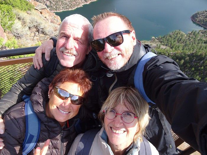
Mimi (Michèle): always the smallest and the funniest. Thank goodness she was there to speak English! Maumau (Maurice): her husband, always with his white hair, his Gallic mustache, his humor, and his Southern accent. He drove every other day. DD (André): the one with the beard, with whom I celebrated our 41st wedding anniversary at Yellowstone. Our second driver appreciated having a peaceful mind since he’s been retired since July. Marcalamar (Martine): that’s me—still blonde with glasses, still talking a lot, and still terrified of messing up the organization of this trip despite all the hours spent on the forum.
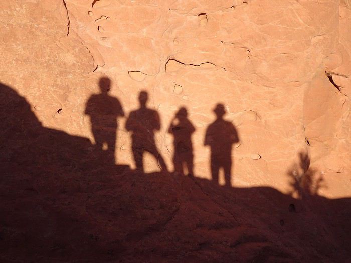 Recognize us? Ha ha ha!!!! No, just kidding!!!!
That’s us!!!
In 2017, struck by western addiction, our first road trip gave us an irresistible urge to return, which we did from September 2nd to 24th, 2019, on a loop from Denver to Denver via Yellowstone. The westernmost point of this journey, which took us through the geographical center of the USA, brought us within about a hundred kilometers of Moab, which had been the easternmost point of our last trip.
We’ve been back for over a month now, and I realize I’m starting to forget some details—it’s high time I started my travel journal before my brain turns into Swiss cheese and lets everything slip away. As I mentioned in my last story, it’ll take me quite a while to finish, so if any travelers have specific questions, don’t hesitate to message me privately. Once again, I’d like to thank everyone who helped me (and there were many!) prepare our road trip, with a special shout-out to Disneydiddl, Hiacinthe, and Titou (ladies first) as well as Fred and Itat, whom I bombarded with questions for months and who always kindly and patiently gave me tons of great tips. It’s thanks to all of you that this trip was such a success. I was a little worried I wouldn’t recapture the emotion and enthusiasm of our 2017 trip, but this one was just as "Wow" as the last.
For those who don’t know us, let me introduce our little group. We’re four friends in our sixties (this time, everyone made it, which let us score some "senior" discounts...). We live in the Var region, have known each other for over 20 years, and this was our second trip together to this magical West.
Mimi (Michèle): always the smallest and the funniest. Thank goodness she was there to speak English! Maumau (Maurice): her husband, always with his white hair, his Gallic mustache, his humor, and his Southern accent. He drove every other day. DD (André): the one with the beard, with whom I celebrated our 41st wedding anniversary at Yellowstone. Our second driver appreciated having a peaceful mind since he’s been retired since July. Marcalamar (Martine): that’s me—still blonde with glasses, still talking a lot, and still terrified of messing up the organization of this trip despite all the hours spent on the forum.
Recognize us? Ha ha ha!!!! No, just kidding!!!!
That’s us!!!Bons petits restaurants typiques au Colorado
Bonjour les amis du forum !🙂
Je poste mon petit message avant de sortir mon Road book sur papier. Si vous n’avez rien à me proposer j’irai jeter un œil sur tripadvisor.
Qui connaîtrait des restos typiques, sympa et sans prétention que vous avez appréciés et ouverts en septembre à Idaho springs ou Georgetown ( Colorado) Sheridan Brigham City Fruita ( Colorado) Cripple creek Manitou springs ou Colorado springs Merci pour vos recommandations Bon dimanche à tous — Marcalamar 🙂
Qui connaîtrait des restos typiques, sympa et sans prétention que vous avez appréciés et ouverts en septembre à Idaho springs ou Georgetown ( Colorado) Sheridan Brigham City Fruita ( Colorado) Cripple creek Manitou springs ou Colorado springs Merci pour vos recommandations Bon dimanche à tous — Marcalamar 🙂
Programme de 4 jours et demi au Yellowstone
Bonjour 🙂
Je vous mets l’itineraire et les visites prévues pour notre séjour dans le Yellowstone.
Merci aux habitués de me dire si c’est cohérent et merci d’avance pour vos suggestions et corrections (au niveau des temps de marche et visite entre autre )
J 8 Cody - Cooke city : par Chief Josef et Beartooth Hwy jusqu’à Rock creek Vista : 200 km Incursion dans le Yell avant de retourner à cooke city : 164 km Lamar Valley. Calcite spring. Tower Falls . Grand Canyon à Canyon Village : Lower Falls ( 1 h 15 aller retour ) puis points de vue en voiture rive Nord Le soleil se couchant à 19h 45 je pense que c’est faisable
J 9 Cooke City - Gardiner : 143 km Lamar Valley. Rive Sud du grand Canyon à Canyon village : Upper Fall Trail ( 15 mn ), Uncle Tom’s Trail ( 1 h ), Artist point ( 10 mn ), Marche vers Point Sublime sans aller jusqu’au bout. Artists Paints pots ( 30 mn ) ( par Norris ) Roaring Mountain Mammoth hot Spring Fort Yell, Upper Terrace en voiture et Lower Terrace à pieds ( 3 h ) Gardiner et baignade Boiling River Trail
J 10 Gardiner- Canyon Village : 178 km Gardiner, Norris Meadow, Muséum of National Park Rangers Norris geyser basin : Porcelaine basin et Back basin ( 3 h ) Canyon Village West thumb ( 2 h) Mud volcano et Sulfur Caldron ( 2 h) Hayden Valley Canyon Village
J 11 Canyon Village - West Yellowstone : 135 km Hayden Valley Lake Village : fishing bridge et Bridge Bay Kepler cascade Upper geyser basin : boucle 8 km 4 h Visite Old Faithful inn Le geyser principal, observation point, balade jusqu’à Morning glory pool, Daisy Group, Castel geyser. Black sand basin et Biscuit Basin : 2 h West Yellowstone
J 12 West Yellowstone ( deuxième nuit ) Madison, Terrace Springs Gibbon Falls Beryl Spring Madison Route Firehole canyon : Firehole Falls, Firehole smimming area Midway geyser basin : 30 mn Grand Prismatic overlook : 45 mn Firehole Lake drive : 45 mn Fountain paint pot : 30 mn Madison West Yellowstone
J13 départ vers Grand téton
Merci d’avance pour vos réponses . Marcalamar 🙂
J 8 Cody - Cooke city : par Chief Josef et Beartooth Hwy jusqu’à Rock creek Vista : 200 km Incursion dans le Yell avant de retourner à cooke city : 164 km Lamar Valley. Calcite spring. Tower Falls . Grand Canyon à Canyon Village : Lower Falls ( 1 h 15 aller retour ) puis points de vue en voiture rive Nord Le soleil se couchant à 19h 45 je pense que c’est faisable
J 9 Cooke City - Gardiner : 143 km Lamar Valley. Rive Sud du grand Canyon à Canyon village : Upper Fall Trail ( 15 mn ), Uncle Tom’s Trail ( 1 h ), Artist point ( 10 mn ), Marche vers Point Sublime sans aller jusqu’au bout. Artists Paints pots ( 30 mn ) ( par Norris ) Roaring Mountain Mammoth hot Spring Fort Yell, Upper Terrace en voiture et Lower Terrace à pieds ( 3 h ) Gardiner et baignade Boiling River Trail
J 10 Gardiner- Canyon Village : 178 km Gardiner, Norris Meadow, Muséum of National Park Rangers Norris geyser basin : Porcelaine basin et Back basin ( 3 h ) Canyon Village West thumb ( 2 h) Mud volcano et Sulfur Caldron ( 2 h) Hayden Valley Canyon Village
J 11 Canyon Village - West Yellowstone : 135 km Hayden Valley Lake Village : fishing bridge et Bridge Bay Kepler cascade Upper geyser basin : boucle 8 km 4 h Visite Old Faithful inn Le geyser principal, observation point, balade jusqu’à Morning glory pool, Daisy Group, Castel geyser. Black sand basin et Biscuit Basin : 2 h West Yellowstone
J 12 West Yellowstone ( deuxième nuit ) Madison, Terrace Springs Gibbon Falls Beryl Spring Madison Route Firehole canyon : Firehole Falls, Firehole smimming area Midway geyser basin : 30 mn Grand Prismatic overlook : 45 mn Firehole Lake drive : 45 mn Fountain paint pot : 30 mn Madison West Yellowstone
J13 départ vers Grand téton
Merci d’avance pour vos réponses . Marcalamar 🙂