Bonjour,
Mon post précédent n'ayant pas suscité un enthousiasme débordant, car sans doute trop général, j'ai affiné mes désidératas et me suis décidé pour une randonnée de 4-5 jours dans le Queyras fin de ce mois. Nous sommes un couple de marcheurs en bonne forme, habitués à de longues randos et à la montagne (sans être montagnards) et les dénivelés ne nous font pas trop peur.
On souhaiterait rester éloignés de la civilisation et faire notre périple en bivouac (tente sur le dos).
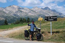
Il me semble d'après les cartes que la partie Est du Queyras est moins civilisée et plus en altitude. J'ai donc pensé partir de St-Véran (j'ai laisserais l'auto), marcher dans le sens anti-horaire classique (pour faciliter la lecture du topo, mais si vous me conseillez l'inverse, je veux bien vous écouter), et arriver quelque part entre Aiguilles et Arvieux, en fonction du temps qu'il nous faudra.
Ma question est: par où passer ? On arrivera début d'après-midi à St-Véran, donc je pensais mettre la tente un peu après la chapelle de Clausis. Le lendemain, j'hésite entre descendre directement vers l'Echalp (et dormir un peu avant d'y arriver) via le lac Egorgéou, ou bien à m'engager dans le Tour du Pain de Sucre. Ca a l'air joli, mais la météo y est souvent plus capricieuse d'après ce que j'ai compris. Que me conseillent les spécialistes du Queyras ?
Ensuite, j'hésite entre rester sur le GR58 entre l'Echalp (ou Ciabot del Pra en fonction du choix précédent) et les Fonts de Cervières, ou bien emprunter les variantes passant par le Col d'Urine et le col des Thures.
Merci pour vos conseils ! 🙂
peut etre est ce trop tardpour vous répondre. Je connais bien le qeyras où nous randonnons depuis de nombreuses années, la chapelle de clausis bonne idée mais je ne suis pas sure qu'il y ait de l'eau. Apres c'est on peu passer par les 2 caramantrans bref et joli détour. Le tour du pain de sucre est sympa ensuite aller vers les fonds de cervieres est interessant .En revenant un bivouac au dessus d'arvieux aux chalets de furfande accesibles uniquemnt à pied serait sympa
Le col d'urine est tres joli aussi on redescend sur le petit hameau du Roux avant de repartir sur les fonds de cervieres mais on évite complètement la vallée et donc les points ravitaillement à vous de voir bo périple
Salut,
difficile d'apporter une réponse objectives aux questions il n'ya pas d'itinéraire prédéfini dans le Queyras sauf suivre éventuellement les GR et PR tous tracés.
C'est pas comme le Tour du Mont Blanc par exemple.
Donc il y a un certain nombre de combinaisons possibles de trajets
Il me semble d'après les cartes que la partie Est du Queyras est moins civilisée et plus en altitude. J'ai donc pensé partir de St-Véran (j'ai laisserais l'auto), marcher dans le sens anti-horaire classique (pour faciliter la lecture du topo, mais si vous me conseillez l'inverse, je veux bien vous écouter), et arriver quelque part entre Aiguilles et Arvieux, en fonction du temps qu'il nous faudra.
le Queyras est très fréquenté en été....
désolé de cette réponse laconique
Les plus beaux coins que j'ai fait c'est Chateau Queyras et le col des Ayes
On souhaiterait rester éloignés de la civilisation et faire notre périple en bivouac (tente sur le dos).
à ce moment-là ne pas aller dans le Queyras ily a du monde en été mais plutôt dans les Rocheuses dans le Yukon 😉
Le tour du Viso comporte quelques coins un peu sauvage.
De Saint-Véran on peut atteindre le sentier qui en fait le tour je l'ai fait une année.
Merci pour vos conseils. On revient de notre (petit) périple et c'est toujours plus sympa de donner un peu de retour.
Le premier jour on est parti de St Véran à 18h (un peu tard, mais il y avait de la route à faire avant) pour bivouaquer sous la Chapelle de Clausis (face à l'ancienne mine de cuivre), près du torrent. Très sympa, même s'il y avait du givre le lendemain matin sur le pré, on n'a donc pas eu très chaud.
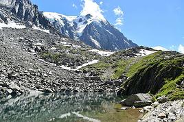
Deuxième jour, nous sommes montés au col de Chamoussière, puis on s'est engagés sur le tour du Pain de Sucre en passant le col d'Agnel. Nous avons bivouaqué après les Granges del Rio, côté italien donc. Il ne faut pas s'aventurer trop loin dans la vallée sous peine de se retrouver entourés de vaches (dont deux ont failli me passer sur le corps le lendemain matin, toutes affairées qu'elles étaient à régler violemment leurs comptes). Environ 1km après les granges del Rio, le chemin s'élève par rapport au torrent et il y a là en contrebas une petite zone plate où poser la tente près de la rivière. Très sympa et plus chaud que la veille.
Le lendemain, on a passé le col della Losetta (très belle vue sur le Viso) et le col Vallante qui permet de repasser du côté français. Une fois ces deux cols passés, ce fut la grosse hésitation. Il ne nous restait plus beaucoup de jours, on n'avait pas envie de dormir entassés dans le refuge du Viso et nos jambes ne voyaient pas d'un très bon oeil l'idée d'ajouter le col Sellière à la journée. De plus, la météo annonçait une dégradation. Du lac Lestio, juste en dessous du col Vallante, on a donc suivi le sentier qui longe le Guil et redescend vers l'Echalp. Un peu à contre-coeur donc, mais pas pour longtemps tant on a trouvé cette vallée magnifique (surtout la première moitié) et calme (peu fréquentée). Nous avons dormi dans la descente, encore une fois, juste avant d'arriver dans les prés-aux-vaches. Le lendemain, on termine la descente vers l'Echalp avec dans l'idée de remonter vers la Crête de Peyra Plata et de passer notre dernière nuit après Collette de Gilly. Mais comme la fin de la descente a pris pas mal de temps, que nos jambes râlaient toujours et qu'on annonçait de la pluie, on a préféré essayer de rejoindre notre auto à St Véran. Bien nous en pris car rallier Ristolas à St Véran ne se fait pas en un clin d'oeil: un bus par jour et encore il faut en changer à Ville-Vieille (l'autostop a bien fonctionné); et surtout il s'est mis à pleuvoir sans discontinuer la nuit et le jour suivants.
Au final, on a bien apprécié cette partie du Queyras. Les paysages y sont très beaux. Par contre, je me demande si c'était bien une bonne idée de vouloir le faire avec la tente et tout l'équipement sur le dos car on n'a jamais vraiment été dans des endroits isolés: tout est plus ou moins accessible via des routes qui sillonnent le parc. Du coup, on crève avec nos baluchons et on se fait dépasser par une foule de gens (jeunes et moins jeunes) qui sautillent de roche en roche avec leur petit sacs pour la journée. Un peu frustrant, surtout qu'ils voient exactement les mêmes paysages que nous. J'ai donc eu l'impression de ne pas avoir été récompensé du surplus d'effort produit à porter lourd, et que les chemins ont volontairement été tracés de façon à repasser régulièrement par des villages où se trouvent hébergements et ravitaillements. D'un côté ça permet à tout le monde d'avoir accès à tout ou presque, ce qui est bien, mais on n'a pas vraiment le sentiment d'être "Into the Wild", à part le soir où on se retrouve seul. Peut-être que la partie nord du GR58 est plus isolée, ce sera à tenter une prochaine fois ?
merci de nous donner de vos nouvelles au retour le périle a été sympa je comprends vos réfexions sur le poids du sac il y a une trentaine d'année nous avions commencé le queyras avec tout le matériel de camping et rapidement abandonné vu le nombre d'hébergements meme si il y en avait moins à ce moment là.
Merci pour le récit c'est intéressant comme point de vue.
mais on n'a pas vraiment le sentiment d'être "Into the Wild", à part le soir où on se retrouve seul.
je l'ai écris dans mon précédent message, le Queyras est très fréquenté en été.
Il vaut mieux aller dans les Ecrins plus sauvages.
Dans le parc des Ecrins, pas de routes avec des casse-c.. en voiture, très peu de refuges, que des sentiers..
Et puis le gros problème c'est les routes qui y montent ; évidemment les casse-pieds en voiture, pardon les gens prennent leur voiture pour aller randonner, donc pollution supplémentaire et nuisances ; pour l'écologie et le développement durable on repassera.
C'est la faute aux responsables de région qui veulent "américaniser" les espaces naturels : bagnole, camping, bagnole, camping.
En cause aussi l'étalement urbain qui grignote de plus en plus les espaces naturels et sauvages.
Du coup, on crève avec nos baluchons et on se fait dépasser par une foule de gens (jeunes et moins jeunes) qui sautillent de roche en roche avec leur petit sacs pour la journée. Un peu frustrant, surtout qu'ils voient exactement les mêmes paysages que nous. J'ai donc eu l'impression de ne pas avoir été récompensé du surplus d'effort produit à porter lourd,
c'est une problématique intéressante; à ce moment-là il faut prendre sa voiture la laisser en stationnement et monter un col pour redescendre prendre sa voiture ce que font une majorité de gens.Mais je n'en vois pas l'intérêt, autant rester chez soi à regarder la télé.
Ensuite pour ces gens avec leurs petits sacs ils ont une logique adaptée à la France mais pas adaptée à des contrées sauvages où il faut être en autonomie.
Mais qu'en est-il du bivouac dans les Ecrins ? C'est, au même titre que la Vanoise, un parc national où d'après ce que j'ai entendu dire, il n'est pas trop conseillé de bivouaquer sous peine d'amendes. C'est une des raisons pour lesquelles j'avais choisi le Queyras, c'est un parc régional pas national. Le bivouac est donc possible dans les Ecrins ?
Et puis le gros problème c'est les routes qui y montent ; évidemment les casse-pieds en voiture, pardon les gens prennent leur voiture pour aller randonner, donc pollution supplémentaire et nuisances ; pour l'écologie et le développement durable on repassera.
C'est la faute aux responsables de région qui veulent "américaniser" les espaces naturels : bagnole, camping, bagnole, camping.
En cause aussi l'étalement urbain qui grignote de plus en plus les espaces naturels et sauvages.
.
Je trouve que ce n'est pas vraiment applicable au Queyras : les villages y sont depuis longtemps, il ne s'agit pas de stations construites de toutes pièces au début de l'or blanc. des personnes y habitent à l'année. Il est donc "naturel" que des routes relient ces villages. Et on est loin d'une abondance de campings dans ce coin là. Il est même difficile d'en trouver.
Le Queyras, ce n'est pas une montagne sauvage, mais une montagne habitée depuis des siècles, aménagée par l'homme (canaux d'irrigation, alpages, routes). Et je trouve qu'au contraire les responsables de région ont globalement su préserver cet écrin, avec un bon équilibre nature/ habitat.
Nous voudrions partir fin mars dans les Pyrénées orientales, pour une rando itinérante de 6 jours. Nous avons un bon (voire très bon...) niveau en rando:…
J'ai beau chercher sur le forum, je suis un peu perdue... Mon mari et moi aimerions faire une randonnee d'une semaine environ, dans les alpes, en ete. Nous…
Recherche itinéraire pour mi septembre (2012), dans le parc du vercors une rando en boucle a partir de villard de lans (ou bien d'ailleurs) Autonomie complète…
Voyager à pied › France › Provence-Côte d'Azur · 4 replies
Je prévois de randonner deux jours fin août dans la vallée des Merveilles, et je voudrais avoir l'avis de ceux d'entre vous qui connaissent le coin sur…
Voyager à pied › France › Provence-Côte d'Azur · 3 replies
Nous souhaiterions partir vendredi pour 4 jours dans le mercantour et arriver idéalement jusqu'à l'Italie. Nous pourrions partir de n'importe où. Quel…
Bonjour,
Nous souhaitons faire le trek de 4 jours reliant Mestia à Ushguli sans agence. Il est précisé dans les descriptifs qu'il existe des hébergement à chaque étape, mais on ne trouve pas d'info sur ces hébergements. Quelqu'un a-t-il des infos et un avis sur ce parcours?
We're planning to trek in Peru and Bolivia and would love to find some local agencies.
If you know any, could you share details on prices and, of course, the names of the agencies?
Which trek would you recommend?
Elocine
Je pars en autonomie totale sur un trek au Maroc (10jrs) Imilchil - Aghbalou.
Trouve t-on des cartouches gaz à vis (Coleman, Primus) à Marrakech (adresse) ou villages entre Imilchil - Aghbalou ?
Si non , trouve-t-on des cartouches Butagaz pour camping-gaz (petit volume 230 gr ...)
Merci d' avance pour vos réponses
Hello, I’d like to embark on a little trip in my home country, Switzerland. I’ll start walking from La Cure, heading toward Le Noirmont first, then I’ll improvise my route—but it’ll probably follow the French border... at least as far as Lac de Joux.
I’ll decide day by day how much farther to go after that. My goal is to stay in nature as much as possible, wander around for as long as I can, and restock food in villages or towns along the way.
I’m thinking of mostly camping, but we’ll see if I end up in a hotel or another campsite depending on my route.
I’d love to reach La Chaux-de-Fonds on foot... maybe even Delémont.
The whole thing should take about a week, give or take.
I’ll be bringing my dog, and I’m preparing for this as soon as I’m ready.
Any tips to make sure everything goes smoothly for us? Things I should know—or avoid? What about shepherds with their flocks of sheep? And isn’t hunting season open right now?
I’m not sure if what I’m planning is even doable, which is why I’m asking around.
This’ll be my first time doing something like this—wandering in nature *and* with a dog. I’m really excited for this adventure... and I need it. Thanks!
We’re really keen on ecosystems and want to hike in "natural" ancient forests—not planted woods or areas heavily degraded by human activity. Travel guides (like Lonely Planet) don’t provide much info on this. Could you point us to the most interesting spots?
Thanks in advance for your tips.
We wish you happy holidays and a fantastic 2026, full of discoveries!
Claire and Albert
Hi, this might not be the right section, but I’d like to know if it’s possible to start mountaineering with another person without necessarily hiring a guide. We’ve done quite a bit of hiking but not mountaineering—we’ll just do a half-day glacier course. After that, we were thinking of starting with La Grande Motte and the Pointe de la Traversière, which were recommended to us. Honestly, for things like roping up and knots, I’ll learn at home with lots of videos and a book.
Hi,
I don’t know Switzerland at all and was wondering if Vallée des Joux and especially Dent de Vaulion are packed early in the morning or late in the afternoon in July and September?
If so, do you have any quieter spots to recommend in the area, or in Luxembourg (yes, I know it’s not the same country 😉)?
Thanks a lot!
I’m starting this thread—lots of travelers here have done this trek.
When RMS is mentioned, it’s this agency: Ruwenzori Mountaineering Services (with an *s*), because there’s another one online called Ruwenzori Mountaineering Service (no *s*).
Their site:
www.rwenzorimountaineeringservices.com/
From what I gather, it’s the local mountain guide agency certified by the government?
Jaimerais savoir si quelqu'un aurait fait des treks sur le Ruwenzori et combien ça coute en moyenne, les infrastructures, les paysages la sécurité sur les lieux, merci beaucoup. J'attends avec impatience vos réponses.
We’re leaving in 9 days for a two-week trip to Madeira, mainly to hike.
From my research, I’ve found that since last year, access to most trails—and systematically for the most popular ones—is now paid. You have to pay an access fee of 4.50 € per person per classified hike in 2026, and even 10.50 € for the most iconic hike: Pico Arieiro to Pico Ruivo. When paying, you also have to choose a day and a 30-minute time slot for your start time. Of course, this reservation is neither changeable nor refundable, even if the weather that day is terrible.
Personally, given the massive influx of tourists to the island in recent years, I don’t mind paying a fee to help maintain the trails. Similarly, setting a limit on the number of people who can hike them per day is certainly preferable to preserve this priceless heritage.
However, what’s much less fair is that in reality, most of the available spots are reserved: 1/ for Madeira residents (which is normal); 2/ for "economic operators" (meaning local tour operators). For example, if you’re a non-resident (independent tourist), no booking is possible for the Pico Arieiro hike for an early morning start before September! So, unfortunately, we’ll have to skip this hike.
It’s the same issue for Ponta de São Lourenço, the 25 Fontes, Pico Ruivo... in short, all the most popular hikes. Oh well, we’ll skip those too!
So my question is: which hikes do you recommend where we won’t face the huge crowds that the others get? And where we can book the day before for the next day, taking the weather into account?
Finally, a quick accommodation question: we’ve booked the first week in Funchal, but I haven’t decided yet for the second week. Do you have any advice on where to stay in the south or north, preferably avoiding overly concrete-heavy and touristy spots?
I’m reposting about the logistics for Samaria Gorge.
I’d love to get recent info, especially about whether it’s possible to park my car in Omalos, do the hike, and then catch a bus back to my vehicle.
In theory, it’s doable, but when you check the KTEL website, there aren’t any feasible schedules listed. If anyone has recently organized this with reliable, verified details, I’d really appreciate it. Thanks in advance!
Hi there,
We’re flying from Montreal to Lyon this August to go hiking in the French Alps. We’ve rented a car and will be staying at campgrounds. We’re planning to do day hikes and want to stay a few days in one spot, do a few hikes, then move on to our next camping spot. Could you share your favorite spots or any recommendations for places to spend a few days with great hikes?
A few details:
We arrive in early August and leave in early September.
We’re looking for day hikes (or shorter), moderate difficulty, with a cumulative elevation gain of no more than 1000m, and of course, beautiful scenery!
We’d prefer not to drive too much—maybe it’s best not to head too far south and deal with unnecessary heat?
Along the same lines, if you know of any great campgrounds where we can start our hike directly without needing the car, we’d love to hear your suggestions!
Bonjour
Souhaitant faire de la randonnée sur cette île, je voudrais d'abord savoir quelle serait la période la plus favorable sachant que j'avais passé quelques jours en novembre 2018 pas pour cette activité mais plus pour une simple découverte de l'île et le temps n'était pas top notamment en montagne. Donc peut on choisir une organisation en étoile sachant que je louerai un véhicule avec éventuellement 2 points d'hébergement.
Je n'envisage pas d'intégrer une structure mais de partir à 2 et de s'organiser sauf si vous me conseillez une agence locale ou un guide local. Enfin même si je compte me procurer les différents supports, carte et topo guide plus gps je vous remercie de bien vouloir me communiquer les randos à faire en priorité
Merci beaucoup pour vos informations
I’m planning to do the Mercantour crossing following the Randoxygène route in mid-July.
I’m used to hiking in the mountains, but I sometimes get vertigo, for example on ridges with drops on both sides. I wanted to check if there are any T4 or T3-T4 sections and find out if there are any very exposed passages—and if so, where—so I can plan an alternative route.
Can anyone give me some info on this?
Thanks!
I’m planning a trip around Cap Corse and the AGRIATES in 2026, from May 8th to 15th (there are still 2 spots left, by the way! Just DM me if you're interested).
I’d love to know which hikes are worth prioritizing in the AGRIATES. We’ll be staying in SALECCIA for two days as our base—what should we focus on from there?
A round trip to IGNHU beach? Any other suggestions?
For Ostricano, I think it’s too far for a round trip...
Thanks for your tips!
Have a great day,
Anie, Toulouse
I’d like to get some info about the GR10 Pyrenees traverse. I need help planning the daily stages and accommodations—my wife isn’t an experienced hiker but walks a lot, so I’d like to schedule shorter walking days and thus a longer overall trip in terms of number of days.
Could anyone give me some help and advice?
Best regards,
New to this forum, I’m planning a pretty big project for 2028.
I’m heading to Nepal to do a trek from Kathmandu all the way to Everest Base Camp (a cool 5,300 m 😄).
This trek is a bit special because even though I’ll be part of a group, I’m going solo (so far, no problem—I’m used to it). But it’s my first real trek, and it’s also a humanitarian one: once I reach base camp, I’ll stay an extra week to help clean up the waste left by tens of thousands of climbers! Since I’m originally from South America, from two countries that share the Andes, I have a deep respect for mountains—they fascinate me. So Everest… it’s kind of the trip of a lifetime!
So, a little question for those who’ve done treks to Everest before… any tips for good mental preparation (I’m already working on the physical side)?
Hi there, I’m planning the Annapurna Circuit for March 2027 and I’m looking for a local agency with a local guide—preferably French-speaking—to arrange this trek for us. Any suggestions? Thanks
Hello!
We’re spending a few days in Toraja country at the end of May. We’d love to do a day trek—taking our time—on a route that’s stunning in terms of scenery, but not a level 5 in difficulty!
Any suggestions you can share, please?
Thanks in advance
I’d like to do the Mare a Mare Sud in May over 4 days. I’ve found quite a few places to stay along the route, but I’m stuck on the start and finish.
I’ll be arriving by plane on Sunday evening and would like to start pretty early on Monday morning. Ideally, accommodation right at the trailhead (Alzu di Gallina) would be amazing, but I can’t find anything. Any tips?
Also, for the transfer from Figari Airport to Porto Vecchio or Alzu di Gallina?
At the end, I’d like to pick up a rental car—any advice on that too?
I’m traveling solo by plane to Catania in May and plan to hike the northern side of Etna, starting from Linguaglossa where I’ll arrive by bus. After that, I’d love some info on how to get up to Piano Provenzana (shuttles or hitchhiking), since it seems there’s no public transport except in the summer. Can you sleep there in a free or cheap refuge, or camp? And how far up can you go without having to hire a guide? Thanks in advance. Bernard.
Bonjour a tous,
je pars en voyage au Maroc en aout et nous allons commencer par nous arrêter a Chefchaouen(nous sommes en voiture).
Ma question: quelqu'un peut il m'indiquer un itinéraire de rando en boucle d'entre 5 et 7 jours aux départ de Chefchaouen dans le parc de Talassemtane passant si possible par le pont de dieux?Ou un guide papier qui en reunis quelques uns?
Nous privilégions le camping sauvage et les gites.
Merci d'avance
Hi there, for those who’ve been recently—is it possible to find other solo travelers in March on the island to share transport or room costs? It doesn’t seem easy to travel on a budget.
If you have any recommendations for simple lodgings or places with dorms, I’d love to hear them.
For those who’ve done multi-day treks while moving around: do you need to bring your own sleeping bag? I’d love to hear about itineraries you’ve done without a guide, just with a map and GPS.
Thanks, and have a great day!
Hi everyone!
We’re planning a 15-day road trip to Scotland this summer, specifically to explore and hike on Lewis and Harris—places we’ve never been before. We’ve visited other islands on previous road trips in Scotland (we usually go in April for a week). This would be our first time in Scotland in the summer and for 15 days. We’re looking at late August to early September.
I’m currently drafting the itinerary. We’d be crossing from Ullapool and were thinking of spending 3 nights on Harris and 4 nights on Lewis.
Does that sound balanced to you? Is it better to keep the same accommodation on Harris and the same on Lewis to explore the area? I’d love to hear about any past experiences you’ve had on these islands.
Thanks!
Hi there, I’m trying to leave for 15 days very soon to São Vicente. I’m either looking to join an agency or figure things out on my own to go hiking on one of these islands or both. From what I’ve seen, it’s not easy to organize with local transport, so it gets expensive. Can I use the services of a small local agency? I’m looking for the simplest way to hike for several days. Also, how do you get from São Vicente to São Nicolau? Thanks in advance and have a great day!
Aichatou
I’ve been wanting to do this for several years, and this year’s the one. Next September, I’ll be trekking in Tusheti (Georgia), from Omalo to Shatili.
Of course, I won’t be renting a vehicle that’d just sit unused. No problem getting to Pshaveli, but from there to Omalo, it’s a dirt road (still the case?)
There must be some form of public transport since there are so many guesthouses, and not all travelers come in a 4x4.
If any of you have been to Omalo, could you confirm that these shared transports exist and how often they run?
we’re planning a trip to Yellowstone and hoping to do a three-day backcountry hike if we get a permit.
if any of you have done this before, could you let me know if it’s possible to find water along the way? And if we can transport it, are we allowed to use a stove?