PETIT RETOUR SUR LE North Artic Trail au Groenland
Ce post vise juste à motiver les gens qui comme moi se questionnait sur comment aller au Groenland ou plutôt, suis-je apte ?
Nous sommes partis en Aout 2011 à deux avec un pote.
L’itinéraire de base va de Kangerlussuaq à Sissimiut. Pour notre part, aimant être plutôt seul, on a préféré faire Sissimiut Kangerlussaq
AVION:
Paris Copenhague
Copenhague Kangerlussuaq
Et après Kangerlussuaq Sissimiut sur place
Il semble qu’on puisse faire Paris Reykjavik (Islande) puis Groenland
Prix 1100E avec le vol intérieur
Détail : prendre ses aises car le climat fait que les vols sont fréquemment annulés (à100km près, cela peut être la purée de poix supère opaque.. cela nous a coûté un jour de rando donc ne prévoyez pas votre retour trop court
GUIDE
Ultra complet : étape, conseil, zoom topographique étape par étape, situation des huttes de chasse : Trekking in Greenland, The Artic Circle Trail, ed. Cicerone, Paddy Dillon.
Un seul défaut : trop complet pour les puristes qui ne veulent pas trop d’infos avant de voyager
MATERIEL :
Après avoir fait pas mal de voyage (surtout à vélo) dans les pays nordiques, nous ne faisons pas de l’ultra léger mais de l’ultra confort : c’est notre choix : résultat : 30kg au départ chacun
Je dirai qu’en faisant attention, on tombe à 20kg, et si on connaît le parcours ou que l’on fait de l’ultra léger : 10 12kg doivent être jouable
MAIS ATTENTION : une fois dans le bain, plus de téléphone (sauf peut-être satellite). Si problème de bouffe ou de blessure, et bien, c’est dans votre pomme…
FREQUENTATION : nous le faisions dans l’autre sens, donc nous avons croisé les gens qui faisaient le parcours usuel : environ 2 personnes par jour. Donc dans le bon sens, vous devriez ne croiser personne
DODO : camping sauvage, et éventuellement les huttes de chasse espacées d’environ 20km : le souci est qu’il y a environ 3 planches en bois pour dormir et je crois que pas mal de personnes mises là-dessus, donc si vous arrivez trop tard, vous dormez par terre ou dehors (donc sans tente)
CLIMAT
Le guide recommande en Aout, nous de même : 20 jours dont les 15 premiers ciel bleu et soleil. T shirt pour marcher, par contre polaire dès la pause voire bonnet. La fraicheur de l’air alliée au soleil qui réchauffe juste comme il faut constitue le plus grand des bonheurs
LA zone de Kangerlussuaq se situe dans un micro climat très positif : c’est pour cela que l’aéroport se situe là, au milieu de nulle part, et que ce trail devrait se faire sous un temps correct.
Attention, on a lu qu’en Juin, les lacs sont glacés
RAVITAILLEMENT
Nourriture : rien, sauf pêche pour les connaisseurs (petits lacs et rivières permanents) : apparemment, ca pêche bien, mais nous, ce fut un échec.
Et des bais un peu partout
Pour l’eau, nous nous sommes embêtée avec gourde et camel back : a posteriori, inutile, les randonneurs croisés avaient une petite bouteille d’eau vide dans la main. On peut boire dans tous les cours d’eau sans micropur, même els petits lacs stagnants… c’est sérieux. Ca fait déjà trois kilos de moins !!
DANGER
Pas d’ours ou autres bêtes curieuses, vous êtes trop au Sud
Eventuellement les Mux Oxen, sorte de bœuf musqués, assez gros : pas méchant mais s’ils se mettent cul à cul en cercle, c’est mauvais signe : il s’agit de leur position de défense, donc éventuellement d’attaque… passez votre chemin en vous éloignant
L’orientation, je pense est le pire des problèmes : les cartes sont light, ou plutôt, en étant au Groenland, vous avez peu de repères : les monts, rivières, lacs se succèdent, et on n’est rarement sûr à 100% d’où on est : il faut bien vérifier sa route, et ne pas hésiter à faire demi tour pour vérifier. Sinon, vous vous enfoncez dans des méandres infinis…
Le chemin est rarement net (passage dans des marécages, de la toundra), les cairns peuvent être loin de votre chemin actuel ou invisible pendant un certain temps… Pour notre part, l’altimètre nous a sauvés à deux reprises pour passer au bon endroit
Si vous vous blessez sérieusement : ben… il ne faut pas vous blessez, puisque pas de téléphone…
ARGENT
Il faut emmener sa nourriture depuis la France vu le prix de tout (un exemple : 10E la pinte de bière)
On peut dormir n’importe où en camping sauvage, même aux abords des « villes ». Les logements bon marché n’existent pas
BILAN
N’hésitez pas, allez-y, c’est énorme. Pas de photo ni de lien sur les paysage… c’est à vous de voir sur place.
C’est pas dur comme rando : peu de dénivelé. Après, à vous de voir ce que vous mettez dans votre sac.
Il faut juste être mûr sur sa capacité à randonner en milieu extrême, même si on a rien vu d’extrême. Le seul pb, c’est l’orientation et le fait d’être totaalement seul pour gérer ses soucis
PS :
Le must !!
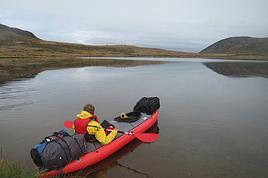
A mi parcours, vous avez des canoës à disposition : ca fait bizarre mais pas de loueur, c’est gratuit. A vous de vérifier l’état des bateaux et des pagaies. Il s’agit d’une étape de 20km qui longe une rivière. Soit à pied donc, soit en bateau. Pas de danger : c’est énoooooooooorme !!
Le souci, c’est qu’une fois la traversée effectuée, le bateau reste à l’arrivée… donc vous comprendrez bien l’utilité de faire la marche en sens inverse… on a de grandes chances d’avoir un canoë amené par les randonneurs qui la font dans l’autre sens….
J’espère que vous n’hésiterez pas !! C’est pas plus violent qu’une rando dans les Alpes
- Nuss le Pingouin -
Les forêts précèdent les hommes, les déserts les suivent
Bravo pour ce trek ! Et un grand merci pour ces notes détaillées, bien pratiques. 🙂
J'envisage aussi de randonner dans cette région.
J'ai 2 questions :
1) Quel mois ? Juin ou septembre ? Je suppose que juillet - août sont + fréquentés, et les prix plus chers. En juin, on a 24 heures de clarté, mais le sol doit être détrempé par la fonte des neiges. Par contre en septembre, il peut déjà neiger. Et d'après ce que j'ai vu (des stats), la météo se gâte déjà.
2) Possibilité d'aller voir l'inlandsis depuis Kangerlusssaq ? Jusque la calotte glaciaire, il doit y avoir 25 - 30 km. Mais peut-on y accéder vraiment ?
j'ai oublié le détail de la calotte effectivement.
Tu as une piste qui part de Kangerlussaq sur 35km. Tu vas tout au bout, et cela s'arrête à l'accès à la calotte.
Celle-ci se dessine progressivement, ca vaut le coup !!
Là-bas, rien d'autre à part toi et la glace: poser la tente est un régal... si tu es fan de bière, à boire en contemplant, c'est pas mal..
Sur la route, tu as deux monts à visiter pour un détour... c'est dans le guide: le Sugar Loaf et un autre, je ne sais plus... je ne pense pas que cela soit indispensable à faire. Le tout est détaillé dans le guide
De Kanger, on te propose de le faire en 4*4 pour très très cher... je n'y vois aucun intérêt à part de l'extrême confort.
Nous avons fait l'aller et le retour en 1 jour et demi à chaque fois. Nous avons croisés 2 voitures à l'aller, 0 au retour. Uniquement des scientifiques
La piste reste agréable pour la rando.
Le problème, c'est de faire la même chose au retour... Je recommande vivement de prendre le chemin rouge sur les cartes qui monte à droite au bout de qques km: chemin de crête qui passe à côté des lacs d'altitude.
Très très dur à trouver, mais ca vaut vraiment le détour !!
Il te restera peut-être 5km jusqu'à l'aéroport une fois sorti.
A Kanger, tu peux prendre juste une douche, même si tu dors en sauvage.
Pour la période: vu les marécages traversés, je pense que Juin doit être compliqué, avec surement pas mal de brume, encore un peu de glace sur les lacs, et de l'humidité au large.
Si tu maîtrises la rando (que tu es affuté au niveau de l'orientation, que tu n'as pas peur d'être mouillé lgtps et que le confort n'est pas un souci, ca doit être génial... Septembre, j'ai lu qu'effectivement, tu avais le risque d'avoir qques chutes de neige....
L'idéal est août: pour aller à la calotte, nous avons croisé un seul randonneur; sur Sissimiut Kanger, comme je l'ai dit, 1 à 2 par jour en sens inverse. On a rattrapé personne et personne ne nous a doublé..
dans l'autre sens, on a croisé un groupe de deux qui devait par malchance aller au même rythme qu'une femme seule.
Pour les tarifs, sans être sûr, je pense que la saison ne change rien: il me semble que le tarif du billet est invariable peu importe le moment de l'année et le temps à l'avance de prise de billet... à vérifier sur Greenland air
Après, pour les hotels ou autre, nous n'avons fait que du sauvage, je ne peux te dire.
J'espère que ma réponse te convient.
A plus
Le problème est le retour
- Nuss le Pingouin -
Les forêts précèdent les hommes, les déserts les suivent
Oui, ta réponse est vraiment TB. Tu donnes des éléments qui nous ont permis de décider. On va sagement suivre tes conseils et partir en août. On craint quand même un peu une débâcle du style Waterloo, ou water-l'eau.
Chouette ton idée de bière. Bien que Belges, nous préférons le pinard, mais chambrer un bordeau là-bas ne doit pas être facile ...
Plus généralement, ton post est vraiment très encourageant, et rassurant pour des gens comme nous qui nous demandions justement si le Groenland était jouable.
Ton histoire de marécages nous inquiète quand même un peu. Est-il nécessaire d'amener des bottes, de simples chaussures de randonnées suffisent-elles ?
Dans ton petit rapport, tu ne parles pas des moustiques. Par ailleurs j'ai vu que des gens conseillaient de porter une moustiquaire, et se badigeonnaient avec une lotion anti-moustiques. Tout cela est-il bien utile ?
pour les moustiques, moustiquaire indispensable: le lieu étant humide, il y en a en grde quantité à certains endroits. Nous en avons eu les 3 premiers jours.
Nous n'avons pas l'habitude de mettre des lotions malgré plusieurs voyages en nids à moustiques (Islande, Norvège ou Ecosse). On trouve que cela ne sert à rien mais chacun son expérience et ses habitudes. (La moustiquaire ne pèse rien)
Pour les marécages, au mois d'aout, ca doit aller partout: le risque est de mettre un pied où il ne faut pas: ex, mon pote s'est retrouvé avec de la boue au genou et tout est rentré dedans. Chaussures de rando suffiront, mais il faut bien vérifier les zones de traversée pour les gués afin de ne pas se mouiller..
Voilà, content que le post serve, on avait aussi hésité longtemps.
A plus
- Nuss le Pingouin -
Les forêts précèdent les hommes, les déserts les suivent
bonjour merci pour le récit mais quelques remarques,
*emporter de la bière pour randonner c'est ton souhait mais je trouve que c'est se charger un peu inutilement ; d'ailleurs il y a des personnes sur ce forum qui dissertent pendant des heures sur le fait de "randonner léger", curieux qu'elles ne se manifestent pas..
*quand il pleut il vaut mieux s'abriter surtout sous ces latitudes (à moins d'avoir des vêtements de rechange).
Car la température ambiante chute très vite, le corps se refroidit et on risque l'hypothermie, ça m'est arrivé quelques fois au Canada et même dans les Alpes à moyenne altitude
pour le randonnée léger, de notre expérience de "légèreté" façonnée depuis une dizaine d'année dans des conditions parfois complexes, nous avons opté pour le confort gastronomique qui pèse son poids.
C'est un choix et non une incapacité à alléger un sac.
Pour les bière, c'était juste pour l'aller retour à la calotte sur trois jours, c'était pas violent... une fois de plus, c'est juste un choix.
Pour l'abri, le problème est qu'au Groenland, tu n'as pas d'abris! il n 'y a pas d'arbre, juste de la toundra. la roche est arrondie et nous n'avons pas vu de cavité pouvant te mettre à l'abri.
Seules les huttes de chasse peuvent le faire mais elle sont présentes, sur ce trek, toutes les 20 km. Sur les autres, je pense qu'il n'y a rien.
Donc si tu as 7 jours de flottes, tu seras imbibées 7 jours.....
Accessoirement, pour d'autres, les guêtres sont indispensables!!
A plus
- Nuss le Pingouin -
Les forêts précèdent les hommes, les déserts les suivent
Y a t-il trop peu de touristes au Groenland ou pourquoi on ne trouve presque pas de discussions? Je souhaite me rendre à Tasiilaq. D'autres y sont déjà allés?…
J'envisage un voyage au groenland en Aout, principalement de la marche et du camping sauvage. Je n'ai rien trouvé sur le forum mais qu'en est-il des ours…
Je m'apprête à partir en treck en autonomie au groenland au moi d'aout je suis à la recherche d'informations et notamment d'une carte la plus précise possible…
Nous (2 copines) voulons aller rendonner au Groenland cet été. Nous avons l'habitude des treks en autonomie, mais pour le Groenland, J'ai du mal à avoir des…
Hi,
We’re planning to do the 4-day trek from Mestia to Ushguli without an agency. The descriptions mention that there are accommodations at each stop, but we can’t find any details about them. Has anyone got info or feedback on this route?
We're planning to trek in Peru and Bolivia and would love to find some local agencies.
If you know any, could you share details on prices and, of course, the names of the agencies?
Which trek would you recommend?
Elocine
I'm heading out on a fully self-sufficient trek in Morocco (10 days) from Imilchil to Aghbalou.
Can I find screw-on gas canisters (Coleman, Primus) in Marrakech (any addresses?) or in villages between Imilchil and Aghbalou?
If not, are Butagaz canisters for camping gas (small 230g size) available?
Thanks in advance for your tips!
Hello, I’d like to embark on a little trip in my home country, Switzerland. I’ll start walking from La Cure, heading toward Le Noirmont first, then I’ll improvise my route—but it’ll probably follow the French border... at least as far as Lac de Joux.
I’ll decide day by day how much farther to go after that. My goal is to stay in nature as much as possible, wander around for as long as I can, and restock food in villages or towns along the way.
I’m thinking of mostly camping, but we’ll see if I end up in a hotel or another campsite depending on my route.
I’d love to reach La Chaux-de-Fonds on foot... maybe even Delémont.
The whole thing should take about a week, give or take.
I’ll be bringing my dog, and I’m preparing for this as soon as I’m ready.
Any tips to make sure everything goes smoothly for us? Things I should know—or avoid? What about shepherds with their flocks of sheep? And isn’t hunting season open right now?
I’m not sure if what I’m planning is even doable, which is why I’m asking around.
This’ll be my first time doing something like this—wandering in nature *and* with a dog. I’m really excited for this adventure... and I need it. Thanks!
We’re really keen on ecosystems and want to hike in "natural" ancient forests—not planted woods or areas heavily degraded by human activity. Travel guides (like Lonely Planet) don’t provide much info on this. Could you point us to the most interesting spots?
Thanks in advance for your tips.
We wish you happy holidays and a fantastic 2026, full of discoveries!
Claire and Albert
Hi, this might not be the right section, but I’d like to know if it’s possible to start mountaineering with another person without necessarily hiring a guide. We’ve done quite a bit of hiking but not mountaineering—we’ll just do a half-day glacier course. After that, we were thinking of starting with La Grande Motte and the Pointe de la Traversière, which were recommended to us. Honestly, for things like roping up and knots, I’ll learn at home with lots of videos and a book.
I’d love to know if anyone has done treks in the Rwenzori Mountains and how much it costs on average, what the infrastructure is like, the landscapes, and safety in the area. Thanks so much! I’m really looking forward to your replies.
We’re leaving in 9 days for a two-week trip to Madeira, mainly to hike.
From my research, I’ve found that since last year, access to most trails—and systematically for the most popular ones—is now paid. You have to pay an access fee of 4.50 € per person per classified hike in 2026, and even 10.50 € for the most iconic hike: Pico Arieiro to Pico Ruivo. When paying, you also have to choose a day and a 30-minute time slot for your start time. Of course, this reservation is neither changeable nor refundable, even if the weather that day is terrible.
Personally, given the massive influx of tourists to the island in recent years, I don’t mind paying a fee to help maintain the trails. Similarly, setting a limit on the number of people who can hike them per day is certainly preferable to preserve this priceless heritage.
However, what’s much less fair is that in reality, most of the available spots are reserved: 1/ for Madeira residents (which is normal); 2/ for "economic operators" (meaning local tour operators). For example, if you’re a non-resident (independent tourist), no booking is possible for the Pico Arieiro hike for an early morning start before September! So, unfortunately, we’ll have to skip this hike.
It’s the same issue for Ponta de São Lourenço, the 25 Fontes, Pico Ruivo... in short, all the most popular hikes. Oh well, we’ll skip those too!
So my question is: which hikes do you recommend where we won’t face the huge crowds that the others get? And where we can book the day before for the next day, taking the weather into account?
Finally, a quick accommodation question: we’ve booked the first week in Funchal, but I haven’t decided yet for the second week. Do you have any advice on where to stay in the south or north, preferably avoiding overly concrete-heavy and touristy spots?
I’m reposting about the logistics for Samaria Gorge.
I’d love to get recent info, especially about whether it’s possible to park my car in Omalos, do the hike, and then catch a bus back to my vehicle.
In theory, it’s doable, but when you check the KTEL website, there aren’t any feasible schedules listed. If anyone has recently organized this with reliable, verified details, I’d really appreciate it. Thanks in advance!
Hi there,
We’re flying from Montreal to Lyon this August to go hiking in the French Alps. We’ve rented a car and will be staying at campgrounds. We’re planning to do day hikes and want to stay a few days in one spot, do a few hikes, then move on to our next camping spot. Could you share your favorite spots or any recommendations for places to spend a few days with great hikes?
A few details:
We arrive in early August and leave in early September.
We’re looking for day hikes (or shorter), moderate difficulty, with a cumulative elevation gain of no more than 1000m, and of course, beautiful scenery!
We’d prefer not to drive too much—maybe it’s best not to head too far south and deal with unnecessary heat?
Along the same lines, if you know of any great campgrounds where we can start our hike directly without needing the car, we’d love to hear your suggestions!
Hi there,
I’m planning to go hiking on this island and would like to know the best time to do it. I visited for a few days in November 2018—not for hiking but just to explore—and the weather wasn’t great, especially in the mountains. So, is a star-shaped itinerary doable if I rent a car and maybe use two different accommodations?
I’m not planning to join an organized group—just traveling with one other person and organizing things ourselves—unless you’d recommend a local agency or guide. Finally, even though I’ll be getting maps, a topo guide, and a GPS, I’d really appreciate your top hiking recommendations.
Thanks so much for your tips!
I’m planning to do the Mercantour crossing following the Randoxygène route in mid-July.
I’m used to hiking in the mountains, but I sometimes get vertigo, for example on ridges with drops on both sides. I wanted to check if there are any T4 or T3-T4 sections and find out if there are any very exposed passages—and if so, where—so I can plan an alternative route.
Can anyone give me some info on this?
Thanks!
I’m planning a trip around Cap Corse and the AGRIATES in 2026, from May 8th to 15th (there are still 2 spots left, by the way! Just DM me if you're interested).
I’d love to know which hikes are worth prioritizing in the AGRIATES. We’ll be staying in SALECCIA for two days as our base—what should we focus on from there?
A round trip to IGNHU beach? Any other suggestions?
For Ostricano, I think it’s too far for a round trip...
Thanks for your tips!
Have a great day,
Anie, Toulouse
I’d like to get some info about the GR10 Pyrenees traverse. I need help planning the daily stages and accommodations—my wife isn’t an experienced hiker but walks a lot, so I’d like to schedule shorter walking days and thus a longer overall trip in terms of number of days.
Could anyone give me some help and advice?
Best regards,
New to this forum, I’m planning a pretty big project for 2028.
I’m heading to Nepal to do a trek from Kathmandu all the way to Everest Base Camp (a cool 5,300 m 😄).
This trek is a bit special because even though I’ll be part of a group, I’m going solo (so far, no problem—I’m used to it). But it’s my first real trek, and it’s also a humanitarian one: once I reach base camp, I’ll stay an extra week to help clean up the waste left by tens of thousands of climbers! Since I’m originally from South America, from two countries that share the Andes, I have a deep respect for mountains—they fascinate me. So Everest… it’s kind of the trip of a lifetime!
So, a little question for those who’ve done treks to Everest before… any tips for good mental preparation (I’m already working on the physical side)?
Hi there, I’m planning the Annapurna Circuit for March 2027 and I’m looking for a local agency with a local guide—preferably French-speaking—to arrange this trek for us. Any suggestions? Thanks
Hello!
We’re spending a few days in Toraja country at the end of May. We’d love to do a day trek—taking our time—on a route that’s stunning in terms of scenery, but not a level 5 in difficulty!
Any suggestions you can share, please?
Thanks in advance
I’d like to do the Mare a Mare Sud in May over 4 days. I’ve found quite a few places to stay along the route, but I’m stuck on the start and finish.
I’ll be arriving by plane on Sunday evening and would like to start pretty early on Monday morning. Ideally, accommodation right at the trailhead (Alzu di Gallina) would be amazing, but I can’t find anything. Any tips?
Also, for the transfer from Figari Airport to Porto Vecchio or Alzu di Gallina?
At the end, I’d like to pick up a rental car—any advice on that too?
I’m traveling solo by plane to Catania in May and plan to hike the northern side of Etna, starting from Linguaglossa where I’ll arrive by bus. After that, I’d love some info on how to get up to Piano Provenzana (shuttles or hitchhiking), since it seems there’s no public transport except in the summer. Can you sleep there in a free or cheap refuge, or camp? And how far up can you go without having to hire a guide? Thanks in advance. Bernard.
Hi everyone,
I’m heading to Morocco in August and we’ll start with a stop in Chefchaouen (we’re driving).
My question: can anyone suggest a 5-to-7-day loop hiking route from Chefchaouen in Talassemtane Park, ideally passing by the God’s Bridge? Or a paper guidebook that covers a few options?
We prefer wild camping and guesthouses.
Thanks in advance
Hi there, for those who’ve been recently—is it possible to find other solo travelers in March on the island to share transport or room costs? It doesn’t seem easy to travel on a budget.
If you have any recommendations for simple lodgings or places with dorms, I’d love to hear them.
For those who’ve done multi-day treks while moving around: do you need to bring your own sleeping bag? I’d love to hear about itineraries you’ve done without a guide, just with a map and GPS.
Thanks, and have a great day!
Hi everyone!
We’re planning a 15-day road trip to Scotland this summer, specifically to explore and hike on Lewis and Harris—places we’ve never been before. We’ve visited other islands on previous road trips in Scotland (we usually go in April for a week). This would be our first time in Scotland in the summer and for 15 days. We’re looking at late August to early September.
I’m currently drafting the itinerary. We’d be crossing from Ullapool and were thinking of spending 3 nights on Harris and 4 nights on Lewis.
Does that sound balanced to you? Is it better to keep the same accommodation on Harris and the same on Lewis to explore the area? I’d love to hear about any past experiences you’ve had on these islands.
Thanks!
Hi there, I’m trying to leave for 15 days very soon to São Vicente. I’m either looking to join an agency or figure things out on my own to go hiking on one of these islands or both. From what I’ve seen, it’s not easy to organize with local transport, so it gets expensive. Can I use the services of a small local agency? I’m looking for the simplest way to hike for several days. Also, how do you get from São Vicente to São Nicolau? Thanks in advance and have a great day!
Aichatou
I’ve been wanting to do this for several years, and this year’s the one. Next September, I’ll be trekking in Tusheti (Georgia), from Omalo to Shatili.
Of course, I won’t be renting a vehicle that’d just sit unused. No problem getting to Pshaveli, but from there to Omalo, it’s a dirt road (still the case?)
There must be some form of public transport since there are so many guesthouses, and not all travelers come in a 4x4.
If any of you have been to Omalo, could you confirm that these shared transports exist and how often they run?
we’re planning a trip to Yellowstone and hoping to do a three-day backcountry hike if we get a permit.
if any of you have done this before, could you let me know if it’s possible to find water along the way? And if we can transport it, are we allowed to use a stove?
Hello,
I’ll be in Nepal from March 6th to 29th (we’re flying into Kathmandu via Varanasi and leaving via Delhi).
I’m a bit confused about the regulations requiring a guide.
My wife and I (we’re 63 and 64) aren’t experienced trekkers—we’re more used to walking on terrain with very moderate elevation changes. I’m looking for fairly easy hikes, possibly day trips.
Here are my questions:
- Does the Poon Hill trek from Pokhara require a guide, or is it better to go through a local agency? (I’ve seen a lot of them offering 4-day packages)
- I’d like to do a few multi-day hikes around Jomsom (Kagbeni, Mukitinath, Lupra, Marpha)... Do you need a guide for those, and can you find accommodations easily without booking in advance?
Last question—I’m really hesitant to lug around a sleeping bag or down jacket during our 6 weeks in India. Can you easily find these kinds of items at reasonable prices in Pokhara?
Thanks in advance for any tips you can share!
Yann
I’m a 56-year-old man who’s done several treks in Nepal and elsewhere. Also passionate about photography.
I’m looking for one or more people to form a group for a trek in Nepal. The trek is the Annapurna and Manaslu circuit (24 days), including a stop at Tilicho Lake. I’ve got a great itinerary and the local company seems solid. The price is around $1600.
I’ll be in Nepal from April 5 to May 12, 2026, so the trek would need to happen within those dates.