Se rendre au monastère de Phuktal au Zanskar
by Edith22
This discussion is in French, the community’s main language.
Original post
Bonjour
J'envisage de me rendre au Ladak l'été prochain.
J'aimerai voir le monastère de Phuktal au Zanskar. Le réseau routier se développant considérablement dans ces deux régions, la seule possibilité de s'en approcher en véhicule est-elle toujours la route Kargil-Padum ? Je précise en véhicule car je n'ai pas le niveau requis pour effectuer un long trek.
Merci à ceux qui en reviennent.
Edith
Bonjour,
Désormais tout va changer très vite au Zanskar avec l'accélération de la construction de la route Darcha-Padum-Nimmu.
Actuellement, la route, plus exactement : la piste, venant de Padum arrive à l'entrée de Cha. Il reste 2h30 de marche sur un sentier aérien mais en bon état pour arriver à Phuktal.
En venant de Keylong et Darcha, la piste franchit le Shingo La et un taxi de Keylong pourrait aller jusqu'à Kargyak, mais il reste plus d'un jour de marche pour arriver à Phuktal.
Julley !
Bonjour,
Merci de m'avoir répondu.
Donc, pour moi, la seule option possible serait la route Kargil-Padum. Mais 2 heures 30 sur un sentier aérien, pour un randonneur confirmé, çà doit bien faire 4-5 heures pour moi. C'est pas gagné ... à moins qu'un moine de passage m'aide à franchir un passage délicat !
J'ai lu qu'il n'y a plus de G.H. au monastère mais seulement 2 places. Pouvez-vous le confirmer ?
Sinon le festival de Sani vaut-il le coup ? N'est-il pas dur de trouver un hébergement au moment des festivals ?
Julley !
Edith
Bonjour,
Lorsqu'on rentre dans les détails, tout se complique !
Donc, pour moi, la seule option possible serait la route Kargil-Padum.
Pour l'année prochaine : oui. Le pont en construction entre Cha et Purne permettra de prendre la route en partie construite entre Purne et le bas de Phuktal, mais pour ça, il faudra attendre 1 ou 2 ans de plus (à mon avis).
Mais 2 heures 30 sur un sentier aérien, pour un randonneur confirmé, çà doit bien faire 4-5 heures pour moi.
Non, il faut 45 minutes pour la grosse grimpette au départ de Cha et 15 minutes de pause au sommet. Ensuite, c'est un sentier descendant jusqu'au pied du gonpa en un peu plus d'une heure et 15 minutes pour remonter jusqu'au gonpa. Ça donne bien : 2h30.
à moins qu'un moine de passage m'aide à franchir un passage délicat !
Les moines pratiquent la lévitation et on les voit passer dans ciel ! ! ! 😎 ! ! !
J'ai lu qu'il n'y a plus de G.H. au monastère mais seulement 2 places. Pouvez-vous le confirmer ?
La guesthouse a été occupée par les moinillons après que leur école, construite au bord de la rivière, ait été emportée par la rupture du barrage de Marshun en mai 2015. Je ne sais pas ce qu'il en est aujourd'hui. On peut parfois être hébergé dans le gonpa lui-même, mais en tant que femme, je ne pense pas que vous y serez autorisée. Je n'ai pas plus de précision car je ne dors plus dans cette guesthouse. Elle était parfaite quand elle était neuve avec salle de bain et eau chaude dans chaque chambre. Mais sans entretien, il n'y a plus d'eau chaude, tous les robinets fuient, et la nourriture consiste à des sachets de soupe ou de pâtes précuites cuites en 3 minutes dans l'eau chaude. A midi, on peut manger avec les moines sur la terrasse du monastère, moines et touristes hommes et femmes confondus. Depuis quelques années, je préfère aller à Purne en un peu moins de 2 heures pour avoir une meilleure chambre et une meilleure nourriture. Si l'histoire des deux chambres libres est toujours d'actualité, la solution est de dormir dans une guesthouse de Cha, puis de partir le matin pour Phuktal et avoir ainsi toutes les chances d'avoir une chambre.
Sinon le festival de Sani vaut-il le coup ? N'est-il pas dur de trouver un hébergement au moment des festivals ?
Oui, c'est un beau festival qui dure deux jours. Le festival de Sani doit avoir lieu les 14 et 15 août 2019. Tous les locaux sont là mais il n'y a pas la foule que l'on voit maintenant dans les festivals des monastères du Ladakh en été. En 2017 par exemple, je n'ai pas pu rentrer dans la cour du gonpa d'Hémis car elle était saturée. Beaucoup de monde, y compris des locaux sont restés à l'extérieur. Ce n'est pas encore le cas au Zanskar. Pour les hébergements, il n'y a rien à Sani, il faut loger à Padum, et des navettes de taxis collectifs et de minibus vont de Padum à Sani le matin et inversement le soir. Entre les hôtels (1000 Rs la nuit) et les guesthouses (600 Rs à Mont Blanc guesthouse), on trouve toujours à se loger.
Voilà pour cet épisode Phuktal-Sani ! Julley, Jean-Louis.
Donc, pour moi, la seule option possible serait la route Kargil-Padum.
Pour l'année prochaine : oui. Le pont en construction entre Cha et Purne permettra de prendre la route en partie construite entre Purne et le bas de Phuktal, mais pour ça, il faudra attendre 1 ou 2 ans de plus (à mon avis).
Mais 2 heures 30 sur un sentier aérien, pour un randonneur confirmé, çà doit bien faire 4-5 heures pour moi.
Non, il faut 45 minutes pour la grosse grimpette au départ de Cha et 15 minutes de pause au sommet. Ensuite, c'est un sentier descendant jusqu'au pied du gonpa en un peu plus d'une heure et 15 minutes pour remonter jusqu'au gonpa. Ça donne bien : 2h30.
à moins qu'un moine de passage m'aide à franchir un passage délicat !
Les moines pratiquent la lévitation et on les voit passer dans ciel ! ! ! 😎 ! ! !
J'ai lu qu'il n'y a plus de G.H. au monastère mais seulement 2 places. Pouvez-vous le confirmer ?
La guesthouse a été occupée par les moinillons après que leur école, construite au bord de la rivière, ait été emportée par la rupture du barrage de Marshun en mai 2015. Je ne sais pas ce qu'il en est aujourd'hui. On peut parfois être hébergé dans le gonpa lui-même, mais en tant que femme, je ne pense pas que vous y serez autorisée. Je n'ai pas plus de précision car je ne dors plus dans cette guesthouse. Elle était parfaite quand elle était neuve avec salle de bain et eau chaude dans chaque chambre. Mais sans entretien, il n'y a plus d'eau chaude, tous les robinets fuient, et la nourriture consiste à des sachets de soupe ou de pâtes précuites cuites en 3 minutes dans l'eau chaude. A midi, on peut manger avec les moines sur la terrasse du monastère, moines et touristes hommes et femmes confondus. Depuis quelques années, je préfère aller à Purne en un peu moins de 2 heures pour avoir une meilleure chambre et une meilleure nourriture. Si l'histoire des deux chambres libres est toujours d'actualité, la solution est de dormir dans une guesthouse de Cha, puis de partir le matin pour Phuktal et avoir ainsi toutes les chances d'avoir une chambre.
Sinon le festival de Sani vaut-il le coup ? N'est-il pas dur de trouver un hébergement au moment des festivals ?
Oui, c'est un beau festival qui dure deux jours. Le festival de Sani doit avoir lieu les 14 et 15 août 2019. Tous les locaux sont là mais il n'y a pas la foule que l'on voit maintenant dans les festivals des monastères du Ladakh en été. En 2017 par exemple, je n'ai pas pu rentrer dans la cour du gonpa d'Hémis car elle était saturée. Beaucoup de monde, y compris des locaux sont restés à l'extérieur. Ce n'est pas encore le cas au Zanskar. Pour les hébergements, il n'y a rien à Sani, il faut loger à Padum, et des navettes de taxis collectifs et de minibus vont de Padum à Sani le matin et inversement le soir. Entre les hôtels (1000 Rs la nuit) et les guesthouses (600 Rs à Mont Blanc guesthouse), on trouve toujours à se loger.
Voilà pour cet épisode Phuktal-Sani ! Julley, Jean-Louis.
Merci d'avoir pris le temps de me répondre en détail.
Je veux y aller en 2019 parce que je sens bien que tout change dans ces contrées. L'éternelle contradiction entre vouloir visiter des lieux "authentiques", pas très touristiques et apprécier les accès aisés ...
Je marche lentement en général. Et très, très lentement dans les descentes. J'appréhende, je suis contractée, je m' y prends mal ... un boulet ! Je dois donc prévoir 4 heures minimum pour faire Cha-Phuktal.
J'ai vu des photos sur votre site internet et dans un ancien post de Fabgreg. Le chemin en rive droite de la Tsarap Chu me semble, je ne peux pas dire plus facile, mais plus "engageant". Mais peut-être je me trompe.
Je devrai donc partir de Cha le plus tôt possible le matin pour profiter un peu du site et revenir éventuellement à Cha.
Ce monastère me fait trop envie et votre réponse me pousse à y aller. Et puis si je ne suis pas à l'aise sur le chemin ... je reviens à Cha ... sans avoir vu Phuktal 🙁
Pour Sani je me doutais bien que je devais dormir à Padum. Me voilà rassurée sur les hébergements en pèriode de festival.
J'aimerais laisser un sac dans une G.H. à Kargil et à Leh ( pas au même moment !). Vous pensez que c'est possible en toute confiance ?
Pour finir "Julley" signifie aussi bien bonjour qu'au revoir ?
Bon week-end et Julley !
Edith
Suite ...
J'ai vu des photos sur votre site internet et dans un ancien post de Fabgreg. Le chemin en rive droite de la Tsarap Chu me semble, je ne peux pas dire plus facile, mais plus "engageant". Mais peut-être je me trompe.
La partie Zanskar de mon site date des année 90'. Plus rien n'est pareil, tout a changé. Il me faut le refaire entièrement, amis je trouve toujours quelque chose de plus urgent, de plus facile et de plus rapide. Le post de Fabgreg sera certainement plus actuel. Le sentier aérien (qui est en rive droite car la rivière descend de Phuktal) a été amélioré et un peu élargi pour faire passer des chevaux et le rinpoché sur son cheval. Le sentier-route de l'autre rive (la gauche qui passe à Purné) va devenir une route. Des Népalais (du Népal) y ont travaillé pendant 3 ans à la pioche et la pelle. Partout où c'était possible, ils ont construit une route de 4,50 m de large, et ils ont laissé toutes les barres de rocher inattaquables à la pioche. Les parties de route sont très confortables, et les barres rocheuses sont plus délicates, mais un sentier a été tracé pour les franchir.
J'aimerais laisser un sac dans une G.H. à Kargil et à Leh (pas au même moment !). Vous pensez que c'est possible en toute confiance ?
A Leh, oui. Ils sont habitués à ça à cause des trekkeurs qui parent pour un trek et reviennent à la fin. Donc aucun problème pour laisser un sac. A Kargil, je ne sais pas mais c'est surtout un lieu de passage. Peut-être les hôtels y sont préparés mais je fréquente plutôt les guesthouses. La Kacho Guesthouse, en face de l'hôpital, le fera certainement et en toute confiance.
Pour finir "Julley" signifie aussi bien bonjour qu'au revoir ?
Oui Julley sert à tout : à dire bonjour, au-revoir, merci, bonne année, etc. Si quelqu'un vous offre 100 000 roupies, alors il faudra dire : Tou.djé.tché, c'est un très grand "merci" qu'on utilise plus rarement.
Julley, Julley, et longue nuit à venir ! Jean-Louis.
J'ai vu des photos sur votre site internet et dans un ancien post de Fabgreg. Le chemin en rive droite de la Tsarap Chu me semble, je ne peux pas dire plus facile, mais plus "engageant". Mais peut-être je me trompe.
La partie Zanskar de mon site date des année 90'. Plus rien n'est pareil, tout a changé. Il me faut le refaire entièrement, amis je trouve toujours quelque chose de plus urgent, de plus facile et de plus rapide. Le post de Fabgreg sera certainement plus actuel. Le sentier aérien (qui est en rive droite car la rivière descend de Phuktal) a été amélioré et un peu élargi pour faire passer des chevaux et le rinpoché sur son cheval. Le sentier-route de l'autre rive (la gauche qui passe à Purné) va devenir une route. Des Népalais (du Népal) y ont travaillé pendant 3 ans à la pioche et la pelle. Partout où c'était possible, ils ont construit une route de 4,50 m de large, et ils ont laissé toutes les barres de rocher inattaquables à la pioche. Les parties de route sont très confortables, et les barres rocheuses sont plus délicates, mais un sentier a été tracé pour les franchir.
J'aimerais laisser un sac dans une G.H. à Kargil et à Leh (pas au même moment !). Vous pensez que c'est possible en toute confiance ?
A Leh, oui. Ils sont habitués à ça à cause des trekkeurs qui parent pour un trek et reviennent à la fin. Donc aucun problème pour laisser un sac. A Kargil, je ne sais pas mais c'est surtout un lieu de passage. Peut-être les hôtels y sont préparés mais je fréquente plutôt les guesthouses. La Kacho Guesthouse, en face de l'hôpital, le fera certainement et en toute confiance.
Pour finir "Julley" signifie aussi bien bonjour qu'au revoir ?
Oui Julley sert à tout : à dire bonjour, au-revoir, merci, bonne année, etc. Si quelqu'un vous offre 100 000 roupies, alors il faudra dire : Tou.djé.tché, c'est un très grand "merci" qu'on utilise plus rarement.
Julley, Julley, et longue nuit à venir ! Jean-Louis.
Suite ...
Plus rien n'est pareil, tout a changé. Il me faut le refaire entièrement, amis je trouve toujours quelque chose de plus urgent, de plus facile et de plus rapide. C'est très compréhensible çà !
A propos de mon sac, je suis idiote, çà ne va pas me fatiguer de l'emmener à Padum🤪 Merci beaucoup pour toutes ces informations. Il y aura d'autre épisodes ... Longue nuit à venir ... et court dimanche! Julley!
Plus rien n'est pareil, tout a changé. Il me faut le refaire entièrement, amis je trouve toujours quelque chose de plus urgent, de plus facile et de plus rapide. C'est très compréhensible çà !
A propos de mon sac, je suis idiote, çà ne va pas me fatiguer de l'emmener à Padum🤪 Merci beaucoup pour toutes ces informations. Il y aura d'autre épisodes ... Longue nuit à venir ... et court dimanche! Julley!
Mais 2 heures 30 sur un sentier aérien, pour un randonneur confirmé, çà doit bien faire 4-5 heures pour moi.
Non, il faut 45 minutes pour la grosse grimpette au départ de Cha et 15 minutes de pause au sommet. Ensuite, c'est un sentier descendant jusqu'au pied du gonpa en un peu plus d'une heure et 15 minutes pour remonter jusqu'au gonpa. Ça donne bien : 2h30.
Dans mon cas, ma marche a suivi très exactement les temps indiqués par Jean-Louis.
J'étais avec mon sac-à-dos principal à pleine charge, un peu masochiste mais c'était pour valider mon aptitude à traverser la chaîne du Zanskar jusqu'à Lamayuru. En fait, c'était le tout premier jour du tout premier trek de ma vie.
Sur ce sentier aérien, bon marcheur ou pas, le temps de marche varie peu. Ce n'est pas vraiment dangereux, mais il ne faut pas mettre un pied en-dehors du sentier, car on risque alors de dévaler la pente (forte déclivité, mais pas de falaise).
Au retour (l'après-midi du même jour), j'ai peiné, et j'ai alors réalisé que l'aller s'était fait très majoritairement en descente. Donc en montée pour le retour. Sans doute ai-je mis 3 h, voire plus.
Djullé à toutes et tous !
Fabrice
P.S. : comme j'avais beaucoup peiné pour ce retour de Phuktal, j'ai ultérieurement accepté de faire porter mon sac-à-dos principal par un âne. Ainsi, la traversée Nord du Zanskar fut confortable. Mais depuis, j'ai toujours porté mon sac-à-dos lors de mes treks. Je prends juste mon temps quand la montée est très pentue.
Non, il faut 45 minutes pour la grosse grimpette au départ de Cha et 15 minutes de pause au sommet. Ensuite, c'est un sentier descendant jusqu'au pied du gonpa en un peu plus d'une heure et 15 minutes pour remonter jusqu'au gonpa. Ça donne bien : 2h30.
Dans mon cas, ma marche a suivi très exactement les temps indiqués par Jean-Louis.
J'étais avec mon sac-à-dos principal à pleine charge, un peu masochiste mais c'était pour valider mon aptitude à traverser la chaîne du Zanskar jusqu'à Lamayuru. En fait, c'était le tout premier jour du tout premier trek de ma vie.
Sur ce sentier aérien, bon marcheur ou pas, le temps de marche varie peu. Ce n'est pas vraiment dangereux, mais il ne faut pas mettre un pied en-dehors du sentier, car on risque alors de dévaler la pente (forte déclivité, mais pas de falaise).
Au retour (l'après-midi du même jour), j'ai peiné, et j'ai alors réalisé que l'aller s'était fait très majoritairement en descente. Donc en montée pour le retour. Sans doute ai-je mis 3 h, voire plus.
Djullé à toutes et tous !
Fabrice
P.S. : comme j'avais beaucoup peiné pour ce retour de Phuktal, j'ai ultérieurement accepté de faire porter mon sac-à-dos principal par un âne. Ainsi, la traversée Nord du Zanskar fut confortable. Mais depuis, j'ai toujours porté mon sac-à-dos lors de mes treks. Je prends juste mon temps quand la montée est très pentue.
S'exposer à l'Etranger lointain amène à mieux connaître et comprendre sa propre Culture.
Merci Fabrice pour votre commentaire.
C'est décidé: j'irai à Phuktal.
Mon souci pour ce voyage est l'appréhension du M.A.M.
Je redoute d'arriver à Leh en avion (pourtant bien pratique) à cause du manque d'acclimatation.
Monter par Manali avec pause de deux jours à Keylong est plus prudent. Mais cà m'ennuie un peu de "gaspiller" 2 jours à Keylong.
C'est l'option que vous aviez choisie qui a ma préférence: Jamnu, Srinagar puis Kargil. On s'acclimate en visitant.
Mais la zone n'est pas "tranquille" depuis quelques temps. Autre appréhension!
Djulley !
Edith
Edith
Mon souci pour ce voyage est l'appréhension du M.A.M.
C'était aussi une inquiétude pour moi. Et finalement, cela s'est passé sans encombre. Tout juste un sommeil léger à Enmu, et une nuit un peu tourmentée au camp de base du Sengge-La (mais c'était dans une tente-parachute ouverte à tout vent).
En fait, en couchant à Enmu (3880 m) dès mon arrivée au Zanskar, j'ai enfreint les règles de progression en altitude, car j'avais passé la nuit précédente à Kargil (2876 m), soit plus de 1000 m de dénivelé. C'est là que mon passage préalable par Mulbekh (3304 m) a sans doute été profitable. C'était précisément l'objectif de cet escapade, même si initialement motivée par la sculpture du grand Maitreya.
Les recommandations françaises portent sur des dénivelés moyennés sur 2 nuitées. L'idée étant de respecter un seuil de 300-400 m de dénivelé positif en moyenne journalière sur 2 nuitées successives. Dans ce cas, entre Mulbekh et Enmu, ma moyenne journalière n'était que de 290 m, soit en-dessous du seuil recommandé.
A ce jour, j'ai eu la chance de ne jamais avoir de véritable souci avec l'altitude, mais c'est très personnel et cela ne garantit pas l'avenir. Je vais avoir l'occasion de le tester en décembre dans le Khumbu (Népal) avec le trek des 3 hauts-cols.
Je redoute d'arriver à Leh en avion (pourtant bien pratique) à cause du manque d'acclimatation. Monter par Manali avec pause de deux jours à Keylong est plus prudent. Mais cà m'ennuie un peu de "gaspiller" 2 jours à Keylong. C'est l'option que vous aviez choisie qui a ma préférence: Jamnu, Srinagar puis Kargil. On s'acclimate en visitant.
C'était effectivement le critère qui m'avait fait choisir cet itinéraire, relativement peu courant. Vous pourrez trouver quelques informations logistiques, en particulier sur le transport, dans le carnet ébauché (malheureusement inachevé) in voyageforum.com/...ost=7042885;#7042885
Depuis Delhi, j'avais pris un train de nuit pour Jammu, puis j'avais enchaîné dès mon arrivée avec un taxi collectif pour Srinagar. Il est aussi possible d'atterrir à Srinagar.
Mais la zone n'est pas "tranquille" depuis quelques temps. Autre appréhension!
Déjà en 2014, Srinagar était déconseillée par le Ministère des Affaires Etrangères français. Rien qui ne m'ait alors vraiment alarmé, car j'avais déjà l'expérience de 2 voyages en Iran (2007, 2010), alors en zone rouge (pour des raisons diplomatiques, en dépit d'une absence totale de risque sécuritaire sur 85% du territoire iranien).
Lors de mon passage, j'avais été troublé par l'intense présence sécuritaire indienne (Police, Armée) à Srinagar. Mais en comparaison avec ce que j'ai vu au Xinjiang (Chine) en septembre dernier, je dirais que les indiens sont des enfants de choeur...
A ma connaissance, il faut vraiment éviter d'y passer certains jours chargés de signification. Par ex. celui de l'Indépendance indienne (15/08). Les vendredi sont aussi susceptibles d'être tendus. Mais hormis un cas tragique (en.wikipedia.org/..._tourists_in_Kashmir) en 1995, il ne semble pas y avoir d'actions contre des occidentaux. Sans aucune comparaison avec les attentats terroristes subis par nombre de pays d'Europe occidentale. De quoi relativiser...
Fabrice
C'était aussi une inquiétude pour moi. Et finalement, cela s'est passé sans encombre. Tout juste un sommeil léger à Enmu, et une nuit un peu tourmentée au camp de base du Sengge-La (mais c'était dans une tente-parachute ouverte à tout vent).
En fait, en couchant à Enmu (3880 m) dès mon arrivée au Zanskar, j'ai enfreint les règles de progression en altitude, car j'avais passé la nuit précédente à Kargil (2876 m), soit plus de 1000 m de dénivelé. C'est là que mon passage préalable par Mulbekh (3304 m) a sans doute été profitable. C'était précisément l'objectif de cet escapade, même si initialement motivée par la sculpture du grand Maitreya.
Les recommandations françaises portent sur des dénivelés moyennés sur 2 nuitées. L'idée étant de respecter un seuil de 300-400 m de dénivelé positif en moyenne journalière sur 2 nuitées successives. Dans ce cas, entre Mulbekh et Enmu, ma moyenne journalière n'était que de 290 m, soit en-dessous du seuil recommandé.
A ce jour, j'ai eu la chance de ne jamais avoir de véritable souci avec l'altitude, mais c'est très personnel et cela ne garantit pas l'avenir. Je vais avoir l'occasion de le tester en décembre dans le Khumbu (Népal) avec le trek des 3 hauts-cols.
Je redoute d'arriver à Leh en avion (pourtant bien pratique) à cause du manque d'acclimatation. Monter par Manali avec pause de deux jours à Keylong est plus prudent. Mais cà m'ennuie un peu de "gaspiller" 2 jours à Keylong. C'est l'option que vous aviez choisie qui a ma préférence: Jamnu, Srinagar puis Kargil. On s'acclimate en visitant.
C'était effectivement le critère qui m'avait fait choisir cet itinéraire, relativement peu courant. Vous pourrez trouver quelques informations logistiques, en particulier sur le transport, dans le carnet ébauché (malheureusement inachevé) in voyageforum.com/...ost=7042885;#7042885
Depuis Delhi, j'avais pris un train de nuit pour Jammu, puis j'avais enchaîné dès mon arrivée avec un taxi collectif pour Srinagar. Il est aussi possible d'atterrir à Srinagar.
Mais la zone n'est pas "tranquille" depuis quelques temps. Autre appréhension!
Déjà en 2014, Srinagar était déconseillée par le Ministère des Affaires Etrangères français. Rien qui ne m'ait alors vraiment alarmé, car j'avais déjà l'expérience de 2 voyages en Iran (2007, 2010), alors en zone rouge (pour des raisons diplomatiques, en dépit d'une absence totale de risque sécuritaire sur 85% du territoire iranien).
Lors de mon passage, j'avais été troublé par l'intense présence sécuritaire indienne (Police, Armée) à Srinagar. Mais en comparaison avec ce que j'ai vu au Xinjiang (Chine) en septembre dernier, je dirais que les indiens sont des enfants de choeur...
A ma connaissance, il faut vraiment éviter d'y passer certains jours chargés de signification. Par ex. celui de l'Indépendance indienne (15/08). Les vendredi sont aussi susceptibles d'être tendus. Mais hormis un cas tragique (en.wikipedia.org/..._tourists_in_Kashmir) en 1995, il ne semble pas y avoir d'actions contre des occidentaux. Sans aucune comparaison avec les attentats terroristes subis par nombre de pays d'Europe occidentale. De quoi relativiser...
Fabrice
S'exposer à l'Etranger lointain amène à mieux connaître et comprendre sa propre Culture.
Bonjour,
je suis allé fin aout 2018 à Puktal voici quelque infos pour complèter ce qui a été bien dit précédemment.
2 bonnes heures de piste pour faire Padum jusque presque Cha, puis les travaux continuent à coup d'explosifs et d'après ce qui se disait la piste au moins jusqu'à Purne serait terminée.
j'ai fait la boucle Cha> Purne pui le lendemain Purne > Puktal > Cha et retour en taxi à Padum.
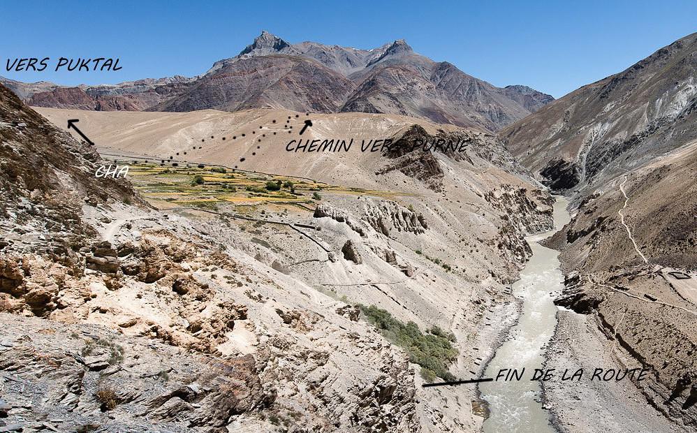
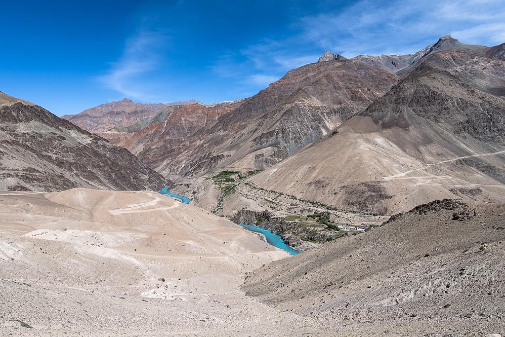
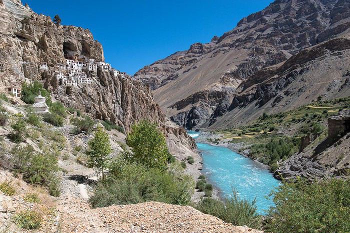
vue au dessus de la route en allant à Cha

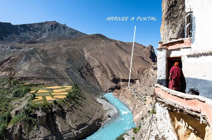
arrivee à Puktal en moins de 2 h sur un chemin facile et qui doit être refait régulièrent sans doutevue depuis le monastère

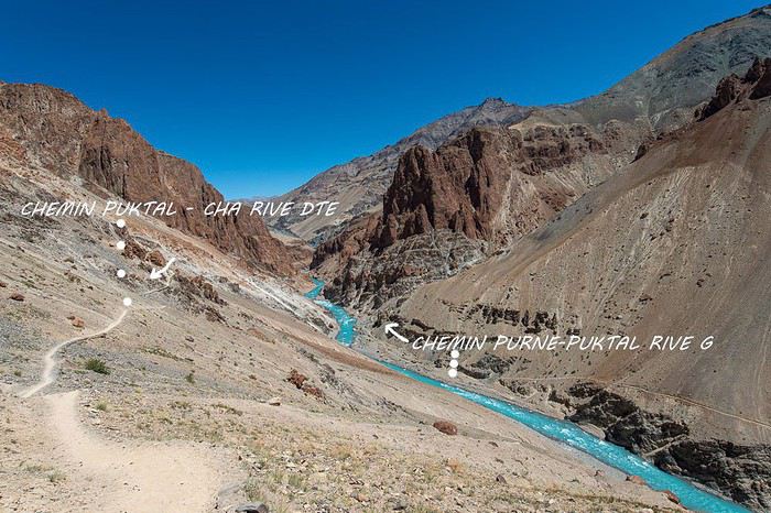
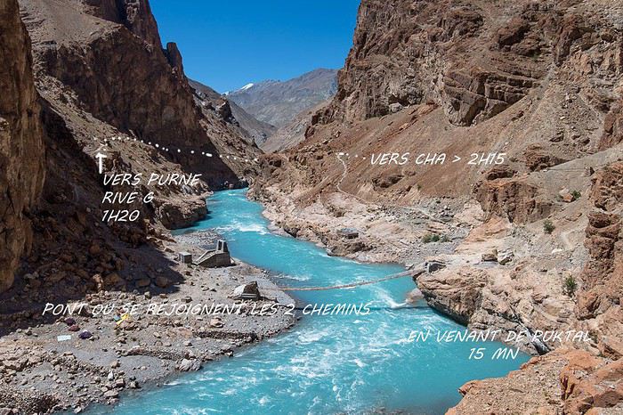
retour vers Cha avec le pont où se rejoignent les chemins de 2 rives

sur cette photo on voit bien le chemin en rive g depuis Purne qui suit sensiblement la rivière alors qu'en direction de Cha ça monte pendant 1h15

en résumé Puktal: 2 petites heures depuis Purne et 2h15 Puktal - Cha (+ 45mn pour retrouver la voiture sur la fin de la route) pour mam difficile à dire, je suis arrivé à Leh, c'était la 3 ème fois que je venais à cette altitude pour commencer un voyage et j'ai eu un peu mal au crane pendant 24h mais après un long voyage et nuit blanche. Après 2 jours c'était terminé en dans la foulée je suis parti à Padum en 2 jours. C'est normal de s'interroger avant le départ mais quand on voit le nombre de touristes au Ladakh, ça n'a pas l'air d'en importuner beaucoup ( et pas qu'au Ladakh).
Bonjour,
Je découvre ces photos et en même temps les changements survenus en 2018.
En particulier cette nouvelle passerelle entre Cha et Purné ! Elle n'existait pas en 2017, et je suppose qu'elle prépare le pont routier de la route Padum-Darcha.
Sur le post précédent, Je n'avais pas bien compris comment vous aviez pu faire Cha-Purné le 1er jour !. Avec cette photo, tout s'explique.
Votre boucle est une bonne solution pour Edith.
Merci pour la photo qui m'a appris quelque chose de très intéressant ... pour l'année prochaine.
Bonjour Édith,
Je viens ajouter mon grain de sel au Mal Aigü des Montagnes.
Il ne faut pas croire que la meilleure solution est de faire la route Manali-Leh. En effet, les "gros" bus la font en deux jours avec une nuit à Keylong à 3150 m, et le lendemain on va enchaîner avec 4 cols à près de 5000 . et plus de 5000 m. Il y a les taxis collectifs (ou non) qui font le trajet en un seul jour. A l'aller, sans acclimatation, ce n'est pas toujours une partie de plaisir et j'ai vu plusieurs fois des gens malades, et deux fois très malades. Comme j'ai fait cette route près de soixante fois, ça ne représente que peu de cas.
Aussi je préfère dire que l'avion est une meilleure solution. Bien sûr, Leh est à 3500 m, mais les cas à problème que j'ai rencontrés, ont été remis sur pied en quelques heures à l'hôpital de Leh. Ils ont tout l'équipement nécessaire, et après être passé dans le caisson pressurisé avec une alimentation en oxygène, ces "malades" sont ressortis en pleine forme. Donc dans le pire des cas, il y a la meilleure des solutions.
Le circuit de Fabrice par Srinagar, permet de monter plus lentement avec Srinagar à environ 2000 m, puis Kargil qu'il a noté à 2876 m, et enfin Leh à 3515m, ou directement Padum à 3560 m. Mais il ne faut pas être malade à Padum car l'hôpital n'est peut-être pas aussi performant que celui de Leh.
La proportion de malades du MAM est très faible, il ne faut pas s'en faire ... une montagne ! Julley !
La proportion de malades du MAM est très faible, il ne faut pas s'en faire... une montagne !
Le tout étant de ne pas en être victime, car dans les mauvais cas, il y a un risque vital.
J'ai trouvé intéressant cet exposé sur https://www.altituderando.com/Le-mal-aigu-des-montagnes-ou-MAM-explications-et-comment-l-eviter.
Parmi les synthèses médicales aisément compréhensibles : - https://www.ffme.fr/uploads/medical/documents/mal-aigu-montagne.pdf. - https://www.ifremmont.com/images/pdf/chap3.pdf.
Bonnes lectures pour Edith, l'initiatrice de cette discussion.
Fabrice
P.S. : merci à Kerola pour ses belles photos. Cela donne envie d'y retourner, même avec ces nouvelles routes balafrant le paysage.
Le tout étant de ne pas en être victime, car dans les mauvais cas, il y a un risque vital.
J'ai trouvé intéressant cet exposé sur https://www.altituderando.com/Le-mal-aigu-des-montagnes-ou-MAM-explications-et-comment-l-eviter.
Parmi les synthèses médicales aisément compréhensibles : - https://www.ffme.fr/uploads/medical/documents/mal-aigu-montagne.pdf. - https://www.ifremmont.com/images/pdf/chap3.pdf.
Bonnes lectures pour Edith, l'initiatrice de cette discussion.
Fabrice
P.S. : merci à Kerola pour ses belles photos. Cela donne envie d'y retourner, même avec ces nouvelles routes balafrant le paysage.
S'exposer à l'Etranger lointain amène à mieux connaître et comprendre sa propre Culture.
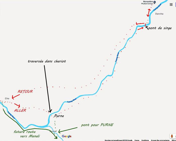
tu as mal compris ou je n'ai pas été assez clair; pour aller de Cha à Purne par le chemin indiqué, je suis resté en rive droite et on se retrouve face à la rivière tsarap et au village de Purne, il n'y a pas de pont mais un chariot pour traverser. Je crois que le trajet habituel était (ou est) de repasser sur la rive gauche entre Enmu et Cha puis retraverser pour remonter vers Purne.
En 2019 la route jusqu'à Purne devrait être finie, fin juin les travaux continuaient au niveau de Cha mais je pense que la route repassera sur l'autre rive mais à quel endroit? (voir carte)
De toute façon il suffira de demander à une agence de Leh ou Padum pour avoir la réponse

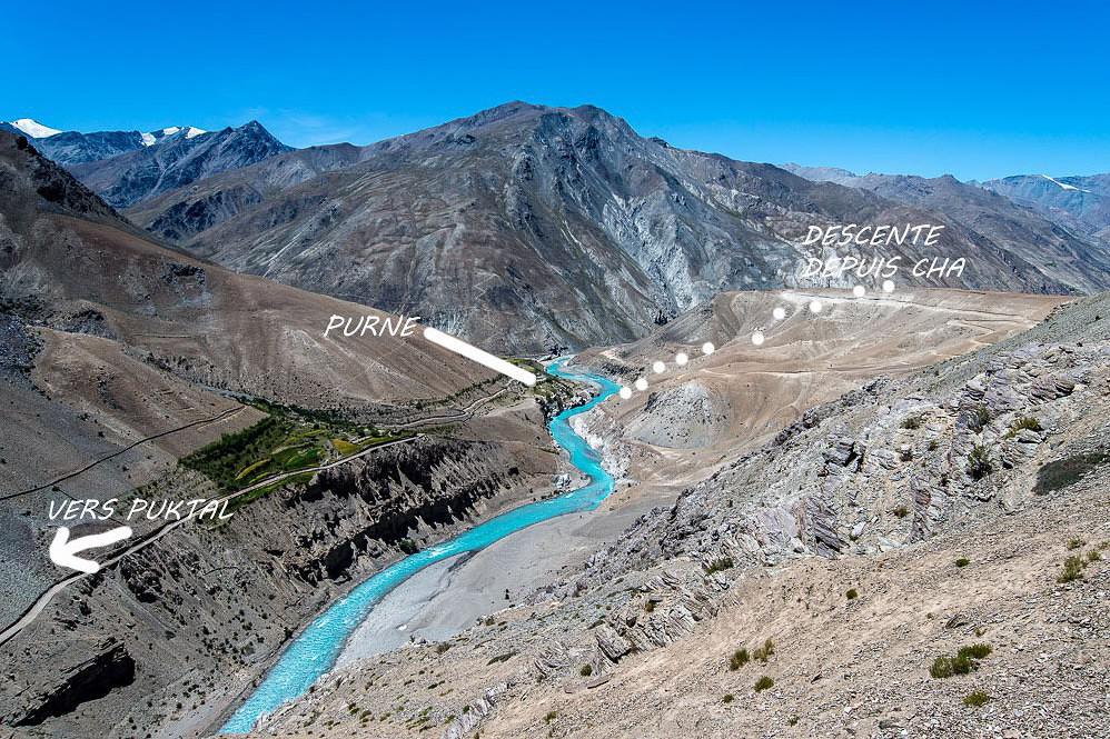
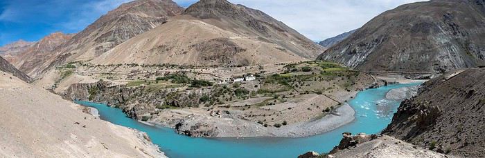
vue sur Purne en provenance de Cha. sur le panoramique en bas: traversée de la rivière Tsarap par un chariot et à droite la rencontre des rivières Tsarap en bleu et Kurgiak en gris avec la future piste (?) en arrière qui ira jusqu'à Manali. C'est par là que l'on arrivera pour se rendre à Puktal

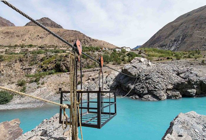
le fameux chariot pour traverser et arriver aux 2 homestays de Purne juste au dessus


vue sur Purne en provenance de Cha. sur le panoramique en bas: traversée de la rivière Tsarap par un chariot et à droite la rencontre des rivières Tsarap en bleu et Kurgiak en gris avec la future piste (?) en arrière qui ira jusqu'à Manali. C'est par là que l'on arrivera pour se rendre à Puktal

le fameux chariot pour traverser et arriver aux 2 homestays de Purne juste au dessus

Merci pour tous ces détails. Ils m'ont permis de recoller tous les bouts de renseignements que tu avais donné avec d'autres que j'avais eu auparavant.
Effectivement pour aller à Purné comme autrefois (c'est à dire jusqu'à l'an dernier), il y a une première passerelle entre Enmu et Tsetan, et une autre entre Dolma Ling (la petite nonnerie) et Kalbok. On arrive alors au dessus du confluent des rivières (Lungnak bleue et Kargyak marron) et une courte passerelle sur la Kargyak Chu permet d'arriver à Purne.
Cette nacelle de Cha à Purné date de l'été dernier. Fin juillet 2016, elle n'existait pas encore quand j'avais dormi à Purné après être passé à Puktal.
Au sujet du tracé de la route de Manali, j'ai posé la question à un habitant de Kuru, petit village en allant vers Kargyak, et j'ai su que cette route restera sur la rive droite, qu'un pont sera construit entre Cha et Purné, et qu'elle continuera jusqu'à Kargyak. Ensuite, elle traversera la rivière au pied du Shingo La pour franchir le col. La piste est déjà faite entre Kargyak et Darcha, mais elle sera élargie car le premier but de cette route est d'abord militaire. Et j'en reviens à la nacelle : elle est là pour transporter les ouvriers et les sacs de ciment pour bâtir le pilier du pont sur l'autre rive, et par la même occasion, tous ceux qui ont besoin de traverser là pour gagner du temps.
Merci encore pour tes infos et toutes tes photos, car il est rare d'avoir des renseignements aussi précis.
Au sujet du tracé de la route de Manali, j'ai posé la question à un habitant de Kuru, petit village en allant vers Kargyak, et j'ai su que cette route restera sur la rive droite, qu'un pont sera construit entre Cha et Purné, et qu'elle continuera jusqu'à Kargyak. Ensuite, elle traversera la rivière au pied du Shingo La pour franchir le col. La piste est déjà faite entre Kargyak et Darcha, mais elle sera élargie car le premier but de cette route est d'abord militaire. Et j'en reviens à la nacelle : elle est là pour transporter les ouvriers et les sacs de ciment pour bâtir le pilier du pont sur l'autre rive, et par la même occasion, tous ceux qui ont besoin de traverser là pour gagner du temps.
Merci encore pour tes infos et toutes tes photos, car il est rare d'avoir des renseignements aussi précis.
Venant de quelqu'un d'aussi précis que Jean-Louis, c'est un compliment de poids. Il est vrai que le plan est limpide.
Quel beau bleu laiteux sur ces photos !
Fabrice
Venant de quelqu'un d'aussi précis que Jean-Louis, c'est un compliment de poids. Il est vrai que le plan est limpide.
Quel beau bleu laiteux sur ces photos !
Fabrice
S'exposer à l'Etranger lointain amène à mieux connaître et comprendre sa propre Culture.
Quel beau bleu laiteux sur ces photos !
Et ceci grâce à une catastrophe ! Début janvier 2015, un gros glissement de terrain s'est produit près de Marshun, en amont de Phuktal. Le barrage ainsi formé avait entre 60 et 70 m de haut, et le lac qui s'en suivit atteignit 15 à 18 km de long selon les journaux. Le 7 mai 2015, ce barrage a cédé et la vague de 70 m (au départ, et 7 m en arrivant à Padum) a tout emporté sur son passage : toutes les passerelles et tous les ponts routiers en béton jusqu'à Chiling compris (un nouveau pont vers la Markha Vallée avait été inauguré 5 mois plus tôt en décembre 2014 !) ET, en plus d'emporter les ponts, cette vague a nettoyé, et même récuré, toutes les rives de la rivière et a mis les roches à nu sur tout son parcours. C'est pourquoi, l'été suivant on a pu voir une eau d'un bleu translucide couler au pied de Phuktal. Depuis ce jour l'eau est toujours bleue jusqu'au confluent avec la Kargyak Chu, mais petit à petit ce bleu devient moins limpide car la pluie et la fonte des neiges apporte au fil des jours un peu de boue vers la rivière. On a ainsi aujourd'hui ce bleu laiteux (c'est l'adjectif qui convient) qui ne permet plus de voir les pierres du fond de l'eau, mais donne encore de belles photos !
Une dernière remarque :
Il est vrai que le plan est limpide.
La trace qui est notée :"future route vers Manali" est en réalité la piste de tout temps des caravanes de chevaux entre Darcha et Padum. La future route est celle qui est en construction depuis Padum via Raru-Ichar-Enmu-Cha-Purné-Tanzé-Tablé-Kargyak-ShingoLa-Darcha. Après la construction du pont Cha-Purné, on peut parier que toutes les caravanes abandonneront l'ancien tracé pour une marche plus reposante sur la route.
Et ceci grâce à une catastrophe ! Début janvier 2015, un gros glissement de terrain s'est produit près de Marshun, en amont de Phuktal. Le barrage ainsi formé avait entre 60 et 70 m de haut, et le lac qui s'en suivit atteignit 15 à 18 km de long selon les journaux. Le 7 mai 2015, ce barrage a cédé et la vague de 70 m (au départ, et 7 m en arrivant à Padum) a tout emporté sur son passage : toutes les passerelles et tous les ponts routiers en béton jusqu'à Chiling compris (un nouveau pont vers la Markha Vallée avait été inauguré 5 mois plus tôt en décembre 2014 !) ET, en plus d'emporter les ponts, cette vague a nettoyé, et même récuré, toutes les rives de la rivière et a mis les roches à nu sur tout son parcours. C'est pourquoi, l'été suivant on a pu voir une eau d'un bleu translucide couler au pied de Phuktal. Depuis ce jour l'eau est toujours bleue jusqu'au confluent avec la Kargyak Chu, mais petit à petit ce bleu devient moins limpide car la pluie et la fonte des neiges apporte au fil des jours un peu de boue vers la rivière. On a ainsi aujourd'hui ce bleu laiteux (c'est l'adjectif qui convient) qui ne permet plus de voir les pierres du fond de l'eau, mais donne encore de belles photos !
Une dernière remarque :
Il est vrai que le plan est limpide.
La trace qui est notée :"future route vers Manali" est en réalité la piste de tout temps des caravanes de chevaux entre Darcha et Padum. La future route est celle qui est en construction depuis Padum via Raru-Ichar-Enmu-Cha-Purné-Tanzé-Tablé-Kargyak-ShingoLa-Darcha. Après la construction du pont Cha-Purné, on peut parier que toutes les caravanes abandonneront l'ancien tracé pour une marche plus reposante sur la route.
On a ainsi aujourd'hui ce bleu laiteux (c'est l'adjectif qui convient)
Merci pour l'explication à laquelle je n'avais pas pensé, bien que connaissant la rupture de l'éboulement et le raz-de-marée induit. Auparavant, la couleur bleu laiteux était la marque d'une eau glaciaire chargée de sédiments, sans penser à l'impact de ses rives en aval.
Je me disais juste que je n'avais pas dû être sensible à la couleur lors de mon passage (août 2014). Me voilà rassurer sur mes capacités d'observation.
D'une certaine manière, la Lungnak Chu est devenue une "Oma Chu" 😉.
Après la construction du pont Cha-Purné, on peut parier que toutes les caravanes abandonneront l'ancien tracé pour une marche plus reposante sur la route.
Parce que tu crois qu'il y aura encore des caravanes ?
Fabrice
Merci pour l'explication à laquelle je n'avais pas pensé, bien que connaissant la rupture de l'éboulement et le raz-de-marée induit. Auparavant, la couleur bleu laiteux était la marque d'une eau glaciaire chargée de sédiments, sans penser à l'impact de ses rives en aval.
Je me disais juste que je n'avais pas dû être sensible à la couleur lors de mon passage (août 2014). Me voilà rassurer sur mes capacités d'observation.
D'une certaine manière, la Lungnak Chu est devenue une "Oma Chu" 😉.
Après la construction du pont Cha-Purné, on peut parier que toutes les caravanes abandonneront l'ancien tracé pour une marche plus reposante sur la route.
Parce que tu crois qu'il y aura encore des caravanes ?
Fabrice
S'exposer à l'Etranger lointain amène à mieux connaître et comprendre sa propre Culture.
Parce que tu crois qu'il y aura encore des caravanes ?
Tu as raison ! Je n'avais pas anticipé les conséquences. Bien entendu, avec la route, les trekkeurs circuleront en taxi, les touristes curieux aussi, et toute l'Inde viendra voir les lieux de tournage d'un prochain film (je pense à ce qui se produit au Pangong Tso !). Et là où tous les camions de l'armée pourront circuler, les camions de ravitaillement pour les villages pourront aussi le faire et remplaceront avantageusement les caravanes de chevaux.
Autre détail : J'ai vu sur la photo de Kerola qui montre le pont d'accès à Phuktal qu'il y avait une nouvelle passerelle en construction. J'en avais entendu parler (je n'y suis pas allé cette année : 2018) et je vois que ce sera une passerelle que les chevaux pourront emprunter pour aller ravitailler le village de Shadé à 8 heures de marche de là après Phuktal. La passerelle emportée le 7 mai 2015, à 50 m environ en amont de l'actuelle, était aussi empruntée par les chevaux. La passerelle-balançoire actuelle a été construite en urgence pour permettre un accès au gonpa. Les deux autres constructions d'urgence entre Dolma Lig et Kalbok, ainsi qu'entre Enmu et Tsetan sont sur le même modèle, sont plus longues, et plus balançoires que passerelles ! Voir ici celle entre Enmu et Tsetan.
Tu as raison ! Je n'avais pas anticipé les conséquences. Bien entendu, avec la route, les trekkeurs circuleront en taxi, les touristes curieux aussi, et toute l'Inde viendra voir les lieux de tournage d'un prochain film (je pense à ce qui se produit au Pangong Tso !). Et là où tous les camions de l'armée pourront circuler, les camions de ravitaillement pour les villages pourront aussi le faire et remplaceront avantageusement les caravanes de chevaux.
Autre détail : J'ai vu sur la photo de Kerola qui montre le pont d'accès à Phuktal qu'il y avait une nouvelle passerelle en construction. J'en avais entendu parler (je n'y suis pas allé cette année : 2018) et je vois que ce sera une passerelle que les chevaux pourront emprunter pour aller ravitailler le village de Shadé à 8 heures de marche de là après Phuktal. La passerelle emportée le 7 mai 2015, à 50 m environ en amont de l'actuelle, était aussi empruntée par les chevaux. La passerelle-balançoire actuelle a été construite en urgence pour permettre un accès au gonpa. Les deux autres constructions d'urgence entre Dolma Lig et Kalbok, ainsi qu'entre Enmu et Tsetan sont sur le même modèle, sont plus longues, et plus balançoires que passerelles ! Voir ici celle entre Enmu et Tsetan.
Bonjour,
Merci pour les photos annotées et la carte très explicite. Cà c'est de l'info ! Que la Tsarap conserve son beau bleu turquoise jusqu'à l'été prochain ! J'imagine que le système poulies-cordes du chariot permet à une personne seule de passer? ( la technique et moi ... ) A Padum auriez-vous une guesthouse à recommander? ou à déconseiller?
Edith
Merci pour les photos annotées et la carte très explicite. Cà c'est de l'info ! Que la Tsarap conserve son beau bleu turquoise jusqu'à l'été prochain ! J'imagine que le système poulies-cordes du chariot permet à une personne seule de passer? ( la technique et moi ... ) A Padum auriez-vous une guesthouse à recommander? ou à déconseiller?
Edith
Je ne suis allé au Zanskar qu'une unique fois, le temps de rejoindre Lamayuru depuis Phuktal.
Hormis cette trop courte expérience, je tiens de Jean-Louis (Djullé84) l'essentiel de ce que je connais. Et j'apprends encore comme en témoigne nos récents échanges.
Fabrice
Hormis cette trop courte expérience, je tiens de Jean-Louis (Djullé84) l'essentiel de ce que je connais. Et j'apprends encore comme en témoigne nos récents échanges.
Fabrice
S'exposer à l'Etranger lointain amène à mieux connaître et comprendre sa propre Culture.
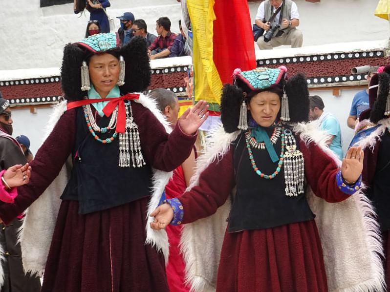
Très bien cette nouvelle photo !
Prise à Karsha alors qu'un moine m'avait fait endosser sa coiffe. C'était le lendemain de ma visite à Phuktal.
Bonne préparation pour votre trek ambitieux au Népal.
La préparation livresque est terminée, même si je n'ai pas toutes les réponses. Il n'y aura plus qu'à marcher. Beaucoup moins sauvage que le Zanskar.
Si à l'époque de ma visite de Phuktal, je n'avais pas été si novice, jamais je n'aurais tenté mon programme. Car passer en 1 journée de Kargil (2680 m) à Enmu (3880 m), ce n'était pas très prudent, même si j'avais couché l'avant-veille à Mulbekh (3300 m). Heureusement pour moi, je n'ai pas eu à souffrir du mal de l'altitude.
Pour mon trek à venir dans le Solo-Khumbu, ma montée en altitude sera bien plus progressive.
Fabrice
Prise à Karsha alors qu'un moine m'avait fait endosser sa coiffe. C'était le lendemain de ma visite à Phuktal.
Bonne préparation pour votre trek ambitieux au Népal.
La préparation livresque est terminée, même si je n'ai pas toutes les réponses. Il n'y aura plus qu'à marcher. Beaucoup moins sauvage que le Zanskar.
Si à l'époque de ma visite de Phuktal, je n'avais pas été si novice, jamais je n'aurais tenté mon programme. Car passer en 1 journée de Kargil (2680 m) à Enmu (3880 m), ce n'était pas très prudent, même si j'avais couché l'avant-veille à Mulbekh (3300 m). Heureusement pour moi, je n'ai pas eu à souffrir du mal de l'altitude.
Pour mon trek à venir dans le Solo-Khumbu, ma montée en altitude sera bien plus progressive.
Fabrice
S'exposer à l'Etranger lointain amène à mieux connaître et comprendre sa propre Culture.
Il est vrai que j'en ai vu traverser à 4 pattes ! et j'ai lu sur un post (lequel ? ? ?) qu'une courageuse trekkeuse a demandé qu'on lui bande les yeux et a traversé ainsi en se tenant à son compagnon de voyage ! ! ! C'est ce qu'on appelle une confiance aveugle !
Pourtant, c'est une école de maîtrise de soi : il faut avancer comme les mannequins au défilé, en mettant un pied devant l'autre (indispensable pour avancer ! 🙂 ! à condition de recommencer) bien au centre des panneaux de branches de saule tressées, et en faisant de petits pas.
En faisant de grands pas, on porte son poids plus brutalement sur l'autre pied et on provoque un balancement de haut en bas.
En ne posant pas le pied au milieu, la passerelle se déporte et commence un balancement de droite à gauche encore plus désagréable que celui de haut en bas.
Pour s'entraîner, la passerelle qui est au pied de Phuktal est parfaite. Elle est plus courte que les deux autres (de Enmu et Dolma Ling), et ses balancements sont plus courts et s'arrêtent très vite dès qu'on ne bouge plus.
Mais avant que tu arrives, la nouvelle passerelle que j'ai aperçue sur la photo de Kerola sera construite. Il y a déjà les emplacements des tendeurs de câble et donc elle sera en planches et même les chevaux pourront y passer.
Si tu vas directement à Purné par la nacelle, tu seras obligée le lendemain de prendre la passerelle pour aller à Phuktal. Reste à savoir quelle passerelle ce sera ? J'espère aller voir ça de près. Julley (= Bonsoir)
Mais avant que tu arrives, la nouvelle passerelle que j'ai aperçue sur la photo de Kerola sera construite. Il y a déjà les emplacements des tendeurs de câble et donc elle sera en planches et même les chevaux pourront y passer.
Si tu vas directement à Purné par la nacelle, tu seras obligée le lendemain de prendre la passerelle pour aller à Phuktal. Reste à savoir quelle passerelle ce sera ? J'espère aller voir ça de près. Julley (= Bonsoir)
Je vais élargir la question en demandant si il est nécessaire de réserver des hébergements avant ? A Padum et plus généralement au Ladakh et Zanskar en Juillet / Août.
Merci
Sans entrer dans les détails, je réponds :"Non" ! Dans mon cas : voyage en solo et petit budget, j'ai toujours trouvé facilement jusqu'à présent. Mais la demande est de plus en plus grande pour des hébergements de plus en plus confortables, et même luxueux pour les Indiens qui vont faire des quantités de selfies pour montrer à leur amis et voisins le gros taxi et les grandes chambres de leur voyage ! Et en entrant dans les détails : Au Zanskar, Internet est trop aléatoire, et les guesthouses ne sont pas équipées. Seuls les hôtels comme Ga-sKyid et Chamling Kailash ont un e-mail. Parmi les guesthouses, Mont-Blanc GH est très connue, Himalaya GH est plus basique, et le Tourist Bungalow avec des chambres à 400 Rs (et salle de bain sans eau chaude) ne prend plus de touristes étrangers à mon avis : on me répond toujours : it's full, alors qu'il n'y a personne. Les hôtels ont dû faire une petite pression ? ? Mais attention : en 2019 le Zanskar restera certainement intéressant, ensuite la construction du pont Cha-Purné marquera le début de l'invasion du Zanskar depuis Manali. L'ouverture du tunnel du Rohtang fin 2019 permettra d'aller de Manali à Padum en 2020 dans la journée.
Ailleurs au Zanskar, aucune réservation n'est possible. On trouve presque partout des "homestays" en pension complète à 800 Rs en 2018.
Au Ladakh, il y a de plus en plus d’hôtels, de guesthouses et de homestays chaque année plus chers, bien au delà de l'inflation. Il y aussi de plus en plus de touristes. Autour de Leh, dans le Sham et la Markha Vallée, et environs, les homestays étaient à 1200 Rs cette année (2018), et ils oubliaient souvent de dire qu'il s'agissait de la pension complète ! ! !
Sans entrer dans les détails, je réponds :"Non" ! Dans mon cas : voyage en solo et petit budget, j'ai toujours trouvé facilement jusqu'à présent. Mais la demande est de plus en plus grande pour des hébergements de plus en plus confortables, et même luxueux pour les Indiens qui vont faire des quantités de selfies pour montrer à leur amis et voisins le gros taxi et les grandes chambres de leur voyage ! Et en entrant dans les détails : Au Zanskar, Internet est trop aléatoire, et les guesthouses ne sont pas équipées. Seuls les hôtels comme Ga-sKyid et Chamling Kailash ont un e-mail. Parmi les guesthouses, Mont-Blanc GH est très connue, Himalaya GH est plus basique, et le Tourist Bungalow avec des chambres à 400 Rs (et salle de bain sans eau chaude) ne prend plus de touristes étrangers à mon avis : on me répond toujours : it's full, alors qu'il n'y a personne. Les hôtels ont dû faire une petite pression ? ? Mais attention : en 2019 le Zanskar restera certainement intéressant, ensuite la construction du pont Cha-Purné marquera le début de l'invasion du Zanskar depuis Manali. L'ouverture du tunnel du Rohtang fin 2019 permettra d'aller de Manali à Padum en 2020 dans la journée.
Ailleurs au Zanskar, aucune réservation n'est possible. On trouve presque partout des "homestays" en pension complète à 800 Rs en 2018.
Au Ladakh, il y a de plus en plus d’hôtels, de guesthouses et de homestays chaque année plus chers, bien au delà de l'inflation. Il y aussi de plus en plus de touristes. Autour de Leh, dans le Sham et la Markha Vallée, et environs, les homestays étaient à 1200 Rs cette année (2018), et ils oubliaient souvent de dire qu'il s'agissait de la pension complète ! ! !
On s'éloigne beaucoup du sujet de départ !
Il reste plusieurs endroits peu visités au Ladakh, dont ceux que vous citez :
Mulbek et ses environs, en dormant à la nonnerie de Wakha,
Charasa et la Siachen river (ou Nubra River) avec Murgi et Ensa.
Dah et les villages des environs sont peu visités aussi. Ailleurs, ce sont de petits treks (tous les grands ont été remplacés par une route) qui passent par des hameaux reculés qui ne survivront plus très longtemps.
Bonjour,
Merci pour les photos annotées et la carte très explicite. Cà c'est de l'info ! Que la Tsarap conserve son beau bleu turquoise jusqu'à l'été prochain ! J'imagine que le système poulies-cordes du chariot permet à une personne seule de passer? ( la technique et moi ... ) A Padum auriez-vous une guesthouse à recommander? ou à déconseiller?
Edith
traverser dans la nacelle seul me parait difficile, déjà monter dedans avec un sac à dos puis tirer la corde et en descendre à l'autre bout c'est pas donné à tout le monde. De toute façon l'année prochaine le problème ne se posera plus normalement avec la route qui ira jusqu'à Purne. A padum je n'ai passé qu'une nuit, on m'avait proposé l’hôtel Rigyal pour compenser les homestay très basiques comme à Karsha qui était un peu mon camp de base dans cette région. L'intérêt de cet hotel c'est d'être un peu en retrait du bourg (5mn), une petite salle exterieure où on mange sur une même table, c'est convivial. La chambre était correcte avec une salle de bain qui m'a permis de me laver ailleurs que dans une rivière, la literie est dure mais je crois que c'est souvent le cas et pour tout dire je ne suis pas très difficile. Il y a d'autres hotels un peu en retrait à Padum.
Merci pour les photos annotées et la carte très explicite. Cà c'est de l'info ! Que la Tsarap conserve son beau bleu turquoise jusqu'à l'été prochain ! J'imagine que le système poulies-cordes du chariot permet à une personne seule de passer? ( la technique et moi ... ) A Padum auriez-vous une guesthouse à recommander? ou à déconseiller?
Edith
traverser dans la nacelle seul me parait difficile, déjà monter dedans avec un sac à dos puis tirer la corde et en descendre à l'autre bout c'est pas donné à tout le monde. De toute façon l'année prochaine le problème ne se posera plus normalement avec la route qui ira jusqu'à Purne. A padum je n'ai passé qu'une nuit, on m'avait proposé l’hôtel Rigyal pour compenser les homestay très basiques comme à Karsha qui était un peu mon camp de base dans cette région. L'intérêt de cet hotel c'est d'être un peu en retrait du bourg (5mn), une petite salle exterieure où on mange sur une même table, c'est convivial. La chambre était correcte avec une salle de bain qui m'a permis de me laver ailleurs que dans une rivière, la literie est dure mais je crois que c'est souvent le cas et pour tout dire je ne suis pas très difficile. Il y a d'autres hotels un peu en retrait à Padum.
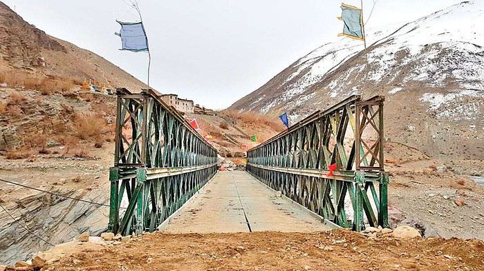
Voilà, c'est fait ! Le pont entre Cha et Purne est terminée. Je viens de voir l'info sur ce journal indien : http://www.thenorthlines.com/ladakh-to-get-all-weather-road-via-himachal/
Manali-Padum se fera désormais en voiture en une petite journée. Toutefois, l'intérêt de ce parcours est de s'arrêter à Purne pour aller visiter Phuktal.
Le trek Darcha-Padum se fera donc en taxi ! Je tremble pour le Zanskar.
J'imagine que le système poulies-cordes du chariot permet à une personne seule de passer? (la technique et moi...)
Il n'y a plus de souci à avoir avec la nacelle, le pont a été construit le mois dernier. Le voici :
Je viens de voir cette photo sur ce journal : https://www.dnaindia.com/india/report-border-roads-organisation-creates-history-constructs-alternative-highway-to-ladakh-2689946
Ce ne sera plus un trek mais une promenade de santé !
Il n'y a plus de souci à avoir avec la nacelle, le pont a été construit le mois dernier. Le voici :

Je viens de voir cette photo sur ce journal : https://www.dnaindia.com/india/report-border-roads-organisation-creates-history-constructs-alternative-highway-to-ladakh-2689946
Ce ne sera plus un trek mais une promenade de santé !
Bonjour
Nous avons séjourné au Ladakh en juillet 2017, ce fut un voyage inoubliable et merveilleux. Nous sommes allés à Padum, secteur qui semble beaucoup moins fréquenté qu'il y a qqs années si on en juge par le nombre d'agences qui on baissé le rideau dans cette petite ville. Plutôt que de faire un long résumé de tout ce que l'on a vécu là-bas, je vous recommande de jeter un coup d’œil sur mon blog en cliquant ICI. Vous y trouverez qqs infos utiles.
Cette destination est un très bon choix, vous serez je pense enchantée par cette région de l'Inde.
Je vous souhaite un excellent séjour au séjour.
Bonjour
Ravi de savoir que mon blog vous ai apporté plein d'infos. La guest house à Padum s'appelait Alpine Guest House elle est située à la sortie de la ville sur la route qui mène au monastère. Il y a deux salles d'eau à l'étage, une sans eau chaude et une autre avec douche chaude qui est utilisée aussi par les proprios. La GH possède aussi deux chambres, moins chères, au rez-de-chaussée sans salle d'eau. Aucune chambre n'a de salle d'eau privative. Il s'agit d'un hébergement chez l'habitant.
N'hésitez pas à me recontacter si vous avez besoin d'infos supplémentaires.
Cordialement
Bonjour EdithMoi aussi je desire aller cet été voir ce monastere. je compte le faire vers le 22 juin . J'irai jusqu'a Padum en Viture et ensuite je ne sais pas encore comment faire pour me rendre à Phuktal
et vous savez vous comment faire et quelle est votre periode
Cordialement
Francine
Bonjour,
Le plus compliqué ext d'aller à Padum. Une fois là, Phuktal c'est tout droit, il n'y a qu'une route.
Cette route a été achevée à la fin de l'an de l'an dernier et un pont entre Cha et Purne a été construit en octobre.
En juin, je crois qu'il n'y a que les bulldozers qui auront roulé sur la dernière partie de la route.
Pour aller à Phuktal, il faut compter 3 jours à pied en dormant dans des homestays (800 Rs nuit et repas compris) à Reru, Enmu, et Phuktal ou Purné.
En taxi on doit aller jusqu'à Purné, en 3 bonnes heures, et il restera 2 heures à pied jusqu'au gonpa.
Les taxis de Padum sont très chers, et il sera intéressant de partager avec d'autres clients, locaux et/ou touristes.
Bonne route
Merci pour tes réponses. j'ai hâte d’être là bas . je connais déjà Padum j'arriverai de Srinagar si tout va bien . après Phuktal je dois me rendre à Lamayuru pour le festival du 29 juin puis Leh ou je retrouve des amis
Bonne journée ou que tu sois Francine
Bonjour Francine,
je connais déjà Padum j'arriverai de Srinagar si tout va bien.
Donc, ce sera Srinagar-Kargil en bus ou en taxi collectif, puis Kargil-Padum en taxi collectif puisqu'il n'y a plus de bus. Srinagar n'est pas très calme en ce moment, en plus en période d'élection, mais les manifestations se passent dans la ville, et au bord du lac, les hôtels et les houseboats sont à l'écart des émeutes. Au pire, tu ne pourras pas aller visiter le centre ville et ses quelques curiosités intéressantes à voir,
après Phuktal je dois me rendre à Lamayuru pour le festival du 29 juin
Pour ça, il faut refaire les 10 h sur la difficile route de Padum à Kargil en taxi collectif. Mais si tu es déjà allé à Padum, tu connais. Ce sera plus délicat pour faire Kargil-Lamayuru : - soit tu arrives assez tôt à Kargil, et sur le nouveau bus stand à l'entrée de la ville, il y a un taxi collectif qui part pour Lamayuru ou Khaltsé, - soit tu réserves aussitôt une place pour le lendemain matin • ou dans le bus Kargil-Leh qui part aux environs de 5 h, • ou dans un taxi collectif qui part le lendemain vers Khaltsé ou Leh, et toujours tôt : 6h ou 7h..
Kargil est une ville sans aucun panneau ni aucune information pour les bus, les minibus ou les taxis collectifs. Il faut poser 20 fois la question pour faire une moyenne des réponses. Attention aussi à ne pas poser une question où la réponse est "oui" ou "non". Car un Indien (qu'il soit de Kargil ou de n'importe quel autre endroit en Inde) répondra toujours "oui" s'il ne comprend pas la question ! ! ! 😇 !
A Lamayuru, les deux jours du festival (29 et 30/06) méritent d'être vus. Si tu peux être à Lamayuru le 26 pour la nuit, tu pourras voir le 27 au matin à 8h, une très grande thanka déroulée sur les 4 étages de la façade de l'hôtel qui ferme la cour du gonpa. Ensuite, ce sont des prières de 9h à 12h, et si tu as réussi à attendre jusque là, tu mangeras avec les moines. Le 28, les moines répèteront leurs pas de danse dans la cour, mais c'est sans intérêt. Il vaut mieux aller faire un tour sur le Moonland ou dans la grotte souterraine d'Atitsé où Naropa médita pensant quelques années. Puis le 29 et le 30 sont consacrés aux célébrations. Le 29 de 7h à 17h avec longue pause de 12h à 14h30. Le 30, ça commence tôt à 7 h et ça finit tard à 19 h. Et le lendemain, 1er juillet, deux processions partiront du gonpa dans deux directions différentes pour aller brûler les "tormas" qui ont été chargés pendant la fête de toux les maux de la terre pour en débarrasser le pays jusqu'à l'année suivante ! (les tormas sont des figurines en pâte de farine d'orge préparées par les moines).
Je n'ai pas de programme officiel des festivités, mais j'ai repris ce que j'avais noté en 2014, en changeant simplement les dates pour mettre celles de 2019.
Je ne sais pas du tout si j'y serai cette année. Je suis en attente d'une opération de la cataracte, et je partirai dès que tout sera redevenu normal. L'opération dure 15 minutes, mais il y a ensuite un mois de gouttes quotidiennes dans les yeux. Alors, j'attends pour prendre mon billet. Bonne journée. J.L.
je connais déjà Padum j'arriverai de Srinagar si tout va bien.
Donc, ce sera Srinagar-Kargil en bus ou en taxi collectif, puis Kargil-Padum en taxi collectif puisqu'il n'y a plus de bus. Srinagar n'est pas très calme en ce moment, en plus en période d'élection, mais les manifestations se passent dans la ville, et au bord du lac, les hôtels et les houseboats sont à l'écart des émeutes. Au pire, tu ne pourras pas aller visiter le centre ville et ses quelques curiosités intéressantes à voir,
après Phuktal je dois me rendre à Lamayuru pour le festival du 29 juin
Pour ça, il faut refaire les 10 h sur la difficile route de Padum à Kargil en taxi collectif. Mais si tu es déjà allé à Padum, tu connais. Ce sera plus délicat pour faire Kargil-Lamayuru : - soit tu arrives assez tôt à Kargil, et sur le nouveau bus stand à l'entrée de la ville, il y a un taxi collectif qui part pour Lamayuru ou Khaltsé, - soit tu réserves aussitôt une place pour le lendemain matin • ou dans le bus Kargil-Leh qui part aux environs de 5 h, • ou dans un taxi collectif qui part le lendemain vers Khaltsé ou Leh, et toujours tôt : 6h ou 7h..
Kargil est une ville sans aucun panneau ni aucune information pour les bus, les minibus ou les taxis collectifs. Il faut poser 20 fois la question pour faire une moyenne des réponses. Attention aussi à ne pas poser une question où la réponse est "oui" ou "non". Car un Indien (qu'il soit de Kargil ou de n'importe quel autre endroit en Inde) répondra toujours "oui" s'il ne comprend pas la question ! ! ! 😇 !
A Lamayuru, les deux jours du festival (29 et 30/06) méritent d'être vus. Si tu peux être à Lamayuru le 26 pour la nuit, tu pourras voir le 27 au matin à 8h, une très grande thanka déroulée sur les 4 étages de la façade de l'hôtel qui ferme la cour du gonpa. Ensuite, ce sont des prières de 9h à 12h, et si tu as réussi à attendre jusque là, tu mangeras avec les moines. Le 28, les moines répèteront leurs pas de danse dans la cour, mais c'est sans intérêt. Il vaut mieux aller faire un tour sur le Moonland ou dans la grotte souterraine d'Atitsé où Naropa médita pensant quelques années. Puis le 29 et le 30 sont consacrés aux célébrations. Le 29 de 7h à 17h avec longue pause de 12h à 14h30. Le 30, ça commence tôt à 7 h et ça finit tard à 19 h. Et le lendemain, 1er juillet, deux processions partiront du gonpa dans deux directions différentes pour aller brûler les "tormas" qui ont été chargés pendant la fête de toux les maux de la terre pour en débarrasser le pays jusqu'à l'année suivante ! (les tormas sont des figurines en pâte de farine d'orge préparées par les moines).
Je n'ai pas de programme officiel des festivités, mais j'ai repris ce que j'avais noté en 2014, en changeant simplement les dates pour mettre celles de 2019.
Je ne sais pas du tout si j'y serai cette année. Je suis en attente d'une opération de la cataracte, et je partirai dès que tout sera redevenu normal. L'opération dure 15 minutes, mais il y a ensuite un mois de gouttes quotidiennes dans les yeux. Alors, j'attends pour prendre mon billet. Bonne journée. J.L.
Un grand merci pour ta réponse , J'ai déjà mon chauffeur rencontré l'année dernière .Je vais peut être rester un peu à Srinagar et venir à Lamayuru tranquillement pour y être le 26 et bien profiter de ce festival .
Mon programme
Je me rendrais ensuite à Leh chez une amie qui a le Leh café ou je resterais quelques jours . Puis Emis pour le festival le 11 juillet et après je ne sais pas encore mais j'aimerai rencontrer des nomades pour le photographier. Je rentre en France le 29 juillet
Bon courage pour cette petite opération à l’œil et j’espère que l'on se verra là bas .
Bonne soirée Francine
Mon programme
Je me rendrais ensuite à Leh chez une amie qui a le Leh café ou je resterais quelques jours . Puis Emis pour le festival le 11 juillet et après je ne sais pas encore mais j'aimerai rencontrer des nomades pour le photographier. Je rentre en France le 29 juillet
Bon courage pour cette petite opération à l’œil et j’espère que l'on se verra là bas .
Bonne soirée Francine
Log in first, then come back to this page.
You might also like
More discussions
Hi there,
After a false start in March 2026 due to my Qatar flights being canceled, I’m rescheduling a trip to Kerala for November. Back in March, I’d booked and paid for the 2-day/1-night trek: Tiger Trail in Periyar National Park. Then I read some terrible reviews about the park. On VF, the reviews are old and don’t mention the Tiger Trail. So, before I book again (I’ve got time), has anyone done it recently and can share their experience and impressions? I’m specifically talking about the Tiger Trail, not the park’s jeep/boat activities, which seem more like an amusement park. Thanks
Hi everyone,
I’m heading to Assam and I’d like to know what type of electrical adapter I need—is it M or D, or both?
Thanks
Hello,
I’m heading to Sri Lanka for 3 weeks in July with my two 11-year-old kids, and I’m wondering about how to organize the trip. We’re used to traveling on the go, staying 1 to 2 or 3 nights per place depending on how we feel.
Do you recommend planning the itinerary and booking accommodations in advance to save time once we’re there? Or is it pretty easy to organize everything as we go without any issues?
Same question for activities: Should we book safaris and tours ahead of time, or can we arrange them easily on the spot? Is there a risk of not getting a spot, for example, to visit a park since we’ll be there in July?
We’ll be using local transport (train, VTC via PickMe, tuk-tuk) to get from one place to another.
In short: Are there any must-book things we should reserve now? So far, I only have the flight tickets!
Thanks in advance for your help! 😊
I’m heading to Sri Lanka for 3 weeks in July with my two 11-year-old kids, and I’m wondering about how to organize the trip. We’re used to traveling on the go, staying 1 to 2 or 3 nights per place depending on how we feel.
Do you recommend planning the itinerary and booking accommodations in advance to save time once we’re there? Or is it pretty easy to organize everything as we go without any issues?
Same question for activities: Should we book safaris and tours ahead of time, or can we arrange them easily on the spot? Is there a risk of not getting a spot, for example, to visit a park since we’ll be there in July?
We’ll be using local transport (train, VTC via PickMe, tuk-tuk) to get from one place to another.
In short: Are there any must-book things we should reserve now? So far, I only have the flight tickets!
Thanks in advance for your help! 😊
Hi there, I think you're on the right track—you plan the itinerary and book the rooms in advance, and that’s it.
Not only do you save time, but you also know where you’ll be staying each night. Choosing well on Booking (or elsewhere) is actually a pleasure!
For safaris, given the number of jeeps with drivers available, it’s unlikely you’ll be turned away... the real issue is more about the concentration of jeeps around the animals.
I travel like you do—train, bus, tuk-tuk, and sometimes taxi. Ride-hailing apps like PickMe and other VTCs are mostly in big cities.
For the mountain train, due to severe flooding, service was interrupted on the line between Kandy and Ella. Check ahead, because reservations for this train are very complicated, if not impossible.
For the Colombo/Kandy train, you reserve your seats by buying the ticket before boarding. In the south, no need to book in advance for trains.
In Sri Lanka, there’s always a solution for getting around—just ask your hosts. They have trusted contacts at their fingertips. But still, compare prices—😏 smart move!
I stick to booking my nights and keep pre-planned activities to a minimum.
For reservations you can’t skip, it’s the beach stays you’ll want to secure.
Hi there,
I’m trying to find out if it’s still possible to travel from Mumbai to Goa by ferry or any other sea route. My search results aren’t very clear, and if it *is* possible, I can’t figure out where to book... If anyone has any info, I’d really appreciate it—thanks in advance!
Have a great day,
Virginie
I’m trying to find out if it’s still possible to travel from Mumbai to Goa by ferry or any other sea route. My search results aren’t very clear, and if it *is* possible, I can’t figure out where to book... If anyone has any info, I’d really appreciate it—thanks in advance!
Have a great day,
Virginie
It seems there’s a ferry from Nagapattinam to Jaffna in India. Has anyone here taken this ferry before? My main question is how to get to Nagapattinam—by train, bus? And from which town further south, of course.
Thanks, friends!
Gaston
Gaston
Hi there.
We’re spending a month in Sri Lanka in March, and we’ll have one week left after leaving Polonnaruwa.
We’re torn between spending it in the Jaffna region or on the east coast between Batticaloa and Trincomalee.
We’re divers, so the east coast appeals to us for snorkeling, beaches, and lagoons—but it seems like late March might not be the best time for that coast. What do you think?
As for Jaffna, the culture of the region, its more authentic feel since it’s less touristy, and the offshore islands all appeal to us too—but it seems far from the rest of the country and harder to access.
We have to choose because we won’t be able to visit both sides, and I’d love to hear your thoughts.
Thanks, Marie
Hi there,
We just got back from a 2-week trip to Sri Lanka as a couple, and while planning the trip, we found plenty of info on the itinerary, places to see, and transportation, but much fewer clear reports on the actual budget to expect once there. Yet, that was an important point for us because we like to plan ahead a little before traveling.
So, we took the time to break down our complete budget after the trip. In our case, we spent around **930 € per person** for 2 weeks, being careful without depriving ourselves, mixing guesthouses, more comfortable hotels, quite a few activities, and even a private driver for part of the stay.
What we found interesting when crunching the numbers is that in Sri Lanka, it’s not necessarily meals or short trips that blow the budget, but rather flights, certain accommodations, cultural activities, and all those little expenses we sometimes forget, like tips.
If this can help other travelers get a better idea, we’ve put everything together on our blog with our experience, a detailed breakdown of expenses, and practical info on money while there, withdrawals, and tipping:
https://aventures-sans-mesaventure.com/budget-sri-lanka-pour-un-voyage-de-2-semaines/
Happy travels and enjoy your adventure! !
Hi everyone,
We’re a group of 5 heading to the Everest Base Camp trek in early April. We won’t have a porter or guide—we’re used to hiking independently and have already done the Langtang trek and the Annapurna Circuit (back in 2003!).
I’d love to know if it’s necessary to book lodges in advance or if we’ll easily find availability during this busy season. Also, will we find lodges all along the route between the main stopover villages, or only in those villages? I remember there were plenty everywhere on the Annapurna Circuit. We want to stay as flexible as possible.
Thanks for your feedback!
We’re a group of 5 heading to the Everest Base Camp trek in early April. We won’t have a porter or guide—we’re used to hiking independently and have already done the Langtang trek and the Annapurna Circuit (back in 2003!).
I’d love to know if it’s necessary to book lodges in advance or if we’ll easily find availability during this busy season. Also, will we find lodges all along the route between the main stopover villages, or only in those villages? I remember there were plenty everywhere on the Annapurna Circuit. We want to stay as flexible as possible.
Thanks for your feedback!
Hi there,
We’re heading to India in March 2026 and had planned to visit the parts of the Meenakshi Temple that are open to non-Hindus. However, the temple is currently undergoing major renovations—with all the towers covered in scaffolding—which might really take away from the experience and our stop in Madurai.
After some frustrating and vague online searches, and before we reshuffle our itinerary, I’d love to know—if possible—the most accurate expected completion date for the renovation work.
Thanks in advance.
We’re heading to India in March 2026 and had planned to visit the parts of the Meenakshi Temple that are open to non-Hindus. However, the temple is currently undergoing major renovations—with all the towers covered in scaffolding—which might really take away from the experience and our stop in Madurai.
After some frustrating and vague online searches, and before we reshuffle our itinerary, I’d love to know—if possible—the most accurate expected completion date for the renovation work.
Thanks in advance.
Hi there,
We’re planning a trip to Nepal and would love to do a helicopter tour to Everest with Namche Heli Service. Has anyone here used this agency? I can’t seem to find any reviews online. Thanks in advance!
Kloki
We’re planning a trip to Nepal and would love to do a helicopter tour to Everest with Namche Heli Service. Has anyone here used this agency? I can’t seem to find any reviews online. Thanks in advance!
Kloki
Hey fellow travelers,
I’m spending two weeks studying Hindi in the mornings in Delhi, in the Hauz Khas neighborhood. What spots should I check out in this area? Any cafés to chill at? How do I get to other parts of Delhi? By rickshaw? Is it easy to negotiate the price upfront?
Thanks in advance. 😊 Marlène
I’m spending two weeks studying Hindi in the mornings in Delhi, in the Hauz Khas neighborhood. What spots should I check out in this area? Any cafés to chill at? How do I get to other parts of Delhi? By rickshaw? Is it easy to negotiate the price upfront?
Thanks in advance. 😊 Marlène
Hi,
I’m leaving this Saturday for Northern India from 15/02 to 27/02. I’m planning to visit New Delhi, Agra, Chand Baori, Jaipur, Ranthambore, Bundi, Udaipur, and Jodhpur.
What’s the best way to get around? I was thinking of doing everything by train. Maybe taking the bus for some stretches?
As for renting a car with a driver, it seems expensive, so I’ve pretty much ruled that out. Unless someone’s got space for the same dates?
Thanks for your insights!
What’s the best way to get around? I was thinking of doing everything by train. Maybe taking the bus for some stretches?
As for renting a car with a driver, it seems expensive, so I’ve pretty much ruled that out. Unless someone’s got space for the same dates?
Thanks for your insights!
Hi everyone,
We’re heading out in March for this trek. We’re used to hiking and long-distance treks, but this’ll be our first time in Nepal.
QUESTION: People from Nepal are telling us it’s MANDATORY to have guides! Is this true, or is it just agencies trying to get work for their staff?
The Lonely Planet says: "In April 2023, the government announced that every trekker would need to hire the services of a porter or a licensed guide to obtain the TIMS permit. The law isn’t enforced, and by 2025, there were no longer any obligations for teahouse treks."
What do you think? What’s your experience? Thanks for your feedback.
We’re heading out in March for this trek. We’re used to hiking and long-distance treks, but this’ll be our first time in Nepal.
QUESTION: People from Nepal are telling us it’s MANDATORY to have guides! Is this true, or is it just agencies trying to get work for their staff?
The Lonely Planet says: "In April 2023, the government announced that every trekker would need to hire the services of a porter or a licensed guide to obtain the TIMS permit. The law isn’t enforced, and by 2025, there were no longer any obligations for teahouse treks."
What do you think? What’s your experience? Thanks for your feedback.
Hi,
I’d like to arrive in India at New Delhi Airport with some cash. I was wondering if the exchange rates at the airport are any good or if it’s best to avoid them (and exchange in the city instead?).
Thanks for your help.
NAMASTE NEPAL! PRACTICAL INFO AND EXPERIENCE FEEDBACK
Stay from March 25 to April 16, 2025
· Flight tickets Air India (via Delhi) (via Skyscanner) = 1130 € per person · Planned budget (and respected without too many restrictions and while buying a few small gifts) = 2000 € for the stay for two. Buses, taxis, and entrance fees to various sites represent a budget to consider. Meals are cheap. Drinks like beer/Coke, however, are not cheap and cost the equivalent of a meal. · Exchange rate of the rupee during our stay = 0.0064 € (the exchange rate is almost identical everywhere, including at the airport). · At the airport, purchase of two SIM cards (phone) = 1000 NPR x 2 for 28 days. · Kathmandu: we had booked the hotel upon arrival: Kathmandu Boutique Hotel (+977 015 357 446 – email: booking@kathmanduboutiquehotel.com), very well located in a quiet alley off the street, south of Thamel, a 10-minute walk from Durbar Square. A hotel like Nepal knows how to do, where tall people will have to duck. Night + breakfast = 18 € for two. Very warm welcome, great location, excellent value for money. · Bhaktapur: we had also booked a hotel for the end of our stay because the chance of the year 2025 made the Nepali New Year and Bisket Jatra particularly festive in Bhaktapur: Manju Baha Hotel School (+977 976 7234014 – email: manjubahahotel@gmail.com) located in an old monastery. "A social enterprise transforming an old monastery into a charming hotel, offering professional hospitality training to underprivileged Nepali youth." Night + breakfast = 32 € for two. Beautifully decorated room. Very warm welcome. Don’t miss the Changunarayan site (near Bhaktapur), it’s amazing. And if you’re lucky enough to be in Bhaktapur in mid-April for 3 days, there’s the Bisket Jatra festivities (Newari festival), joyful, noisy, fun, and wild… · Pokhara (hotel recommended by the Kathmandu hotel): Hotel Green Tara, Lakeside, 10th street, set back, quiet (Tel. +977 61 462698 – email: greentara_67@hotmail.com) · Trek permit (Lower Mustang, no need for an agency or guide, permits checked at Ghasa and Jomsom) = 2000 NPR per person (2 ID photos) · Bus Kathmandu/Pokhara and return = 2000 NPR per person · Bus Pokhara/Jomsom, 2 one-way tickets = 2800 NPR. · Taxi: negotiation with a driver we recommend, Vicky (+977 984 075 599). You explain what you want, negotiate the price, and he waits for you during the visit. Very charming, we used him several times. For example: departure from our hotel at 10 AM -> Boudhanath/Pashupatinath/Patan return at 5 PM to the hotel = 6500 NPR – Swayambhunath (round trip) = 1200 NPR · Site prices: https://ntb.gov.np/plan-your-trip/before-you-come/heritage-site-entry-fees o Visitor Pass for Kathmandu Durbar Square (for the duration of the stay, show your visa) = 1000 NPR per person (1 ID photo) o Bhaktapur Durbar Square (old town) = 1800 NPR per person o Patan = 1000 NPR per person o Swayambhu Stupa = 200 NPR per person o Boudha Stupa = 200 NPR per person o Pashupatinath Temple = 1000 NPR per person (interesting to take a guide) o Changunarayan Temple (6 km north of Bhaktapur) = 400 NPR per person o Mountain Museum in Pokhara = 750 NPR per person · E-cigarettes: e-cigarettes are banned in India and confiscated whether they’re in carry-on or checked luggage. On the way there, we had kept them in our carry-on, they were confiscated in Delhi. On the way back, learning from our previous experience, we put them in our checked luggage. Someone came to get us to take them out of our bags and confiscate them… You can find e-cigarettes and products in Kathmandu.
* * *
I’m 74 years old. I went to Nepal in 1982, 1983, and the last time in 1986. I wanted to introduce this beautiful and endearing country to my husband, and it was… now or never. So we decided it was now.
I knew the trek starting from Pokhara: Naudanda/Birethanti/Ghorepani/Tatopani/Kalopani. There was no way I was going to do that trek, especially the 1000-meter staircase to reach Ghorepani… You have to stay humble with age.
Back then, the road didn’t exist. I didn’t consider, with the construction of this road (NH48) along the western bank of the Kali Gandaki, doing a trek along a windy and dusty road. Was there an alternative hiking trail on the eastern bank? No one answered my question on VoyageForum, so I did my research online. And I found this site: "Andrées de Ruiter and Prem Rai - Trekking the Annapurna Circuit, including the new NATT trails that avoid the road - A guide to one of the most beautiful trekking regions in Nepal and the world (2011) - NATT = New Annapurna Trekking Trail".
Phew! A solution was emerging. This circuit from 2011 wasn’t fully marked. The idea was to go from Jomsom to Tatopani, so we needed to make sure the path was well-marked all the way, which we did, and the path exists, marked in red and white!
So, with the walking times information, we built our 8-day circuit:
· Jomsom/Thinigaon · Thinigaon/Chimang · Chimang/Saura · Saura/Kokhetanti · Rest day or, if in good shape: loop to Sekong Lake · Kokhetanti/Jhipra Deurali · Jhipra Deurali/Kopchepani · Kopchepani/Tatopani
It’s a senior trek, after all. So the walking times noted on the sites indicated 3 hours or even 4 hours for the two longest stages. That pace suited us fine.
On March 29, we left Kathmandu (1400m), after visiting the must-see sites, by bus to Pokhara: 200 km and 8.5 hours on a chaotic road under construction. I had a memory of Pokhara where it was the first city where you could see the Himalayan range, especially Machhapuchhare. But the pollution is such, the dust raised by traffic and construction, that no horizon is visible except the first hills around Pokhara.
We stayed 24 hours in Pokhara (820m), and on March 31, we left our luggage at the hotel and set off with our lightest backpacks: change of clothes, toiletries, first aid kit, anti-chafing cream, water bottle, sleeping bag liner, and light shoes for the stages.
We took the bus to Jomsom: 160 km/7.5 hours including stops for bathroom breaks, tea, and lunch. The road is nothing but a chaos of potholes, landslides, construction, dust, rebuilding, and mudslides. In Ghasa, the bus stops, and we’re told we’re at a checkpoint and that the two foreigners in the bus, my husband and I, need to have our permits checked, which takes a few minutes. The driving is rock-and-roll, surprising, and courteous. The drivers have their codes, and on these improbable roads, they’re virtuosos.
We could have chosen the plane, but several reasons dissuaded us: if there’s too much wind, the planes don’t take off; personally, I wasn’t reassured about landing in Jomsom, and this transport has a cost.
We arrived around 2 PM in Jomsom (2720m), and despite the early wake-up, the nearly 8 hours on the bus, and the altitude, we decided to head straight to Thinigaon (2840m). At the Jomsom checkpoint, they told us it was a 30-minute walk. Great! Except we took an hour and a half on an uphill road, bent over to fight a strong wind. But the Himalayan range is there! The Dhaulagiri, the Nilgiri, the Annapurnas as a reward.
In Thinigaon, we found a room at the "Nilgiri View Hotel" run by a didi (big sister in Nepali). From the lodge’s roof, she proudly showed us the different peaks surrounding the village and told us, worried, that it hadn’t snowed here for 3 years. She said there are very few tourists, that the season is rather in September/October/November. It seems there’s not a soul in this village, yet mules pass through the narrow street paved with large flat stones, their bells ringing. We dine at 6 PM and go to bed… Room = 1200 NPR and dinner, breakfast, and drinks = 2560 NPR.
On April 1, we set off at 9 AM, not for Chimang as planned but for Marpha! The didi from the Thinigaon lodge had said it was a 3-hour walk. The first part of this stage is attractive, the mountains are magnificent and imposing, the landscape is superb, there’s no one around, a feeling of being "alone in the world." We follow Dhumbra Tal, this small green lake. The path is a rocky track that climbs steeply. Then, around a hill, we start the big descent that joins the Kali Gandaki. We face the wind head-on, and the violent gusts take our breath away, throw us off balance, and envelop us in dust. We see the road on the other side of the Kali Gandaki. We arrive in the village of Chhairo at 2 PM, completely exhausted and with blistered feet, after 5 hours of walking instead of the planned 3.5 hours.
We’re welcomed by the village nurse, who tells us there’s a lodge in the village. Chhairo is a Tibetan village, a 20-minute walk from Marpha (according to the locals, multiply by 2 or even 3 for us…). We’re going to revise our trek plan and, first of all, spend the night in Chhairo.
The lodge is quite pleasant, and Karma, the hostess, is very friendly. She asks about our plans and suggests we stay in Chhairo the next day, from where we can visit Marpha and also Chimang, a 1-hour walk away, in light mode, meaning without backpacks. She invites us to participate in a village ceremony the next evening.
We immediately accept the proposal, as our feet need rest and the welcome is so warm… Dinner and bed!
We reworked our trek plan, which was too ambitious for our untrained bodies and, let’s face it… no longer in our first youth. In the initial plan, we thought there wouldn’t be too much elevation gain following the Kali Gandaki, but checking the map, we realize there might be significant elevation changes between Sauru and Sirkung. So we plan:
· Tomorrow: visit Marpha (2670m) and Chimang (2744m) · April 3: bus from Chhairo (2700m) to Kalopani (2530m) and continue on foot to Ghasa (2010m) · April 4: Ghasa/Pairataplo (1940m) · April 5: Pairatapla/Gadpar (1580m) · April 6: Gadpar/Narchyang (1510m) · April 7: Narchyang/Tatopani (1190m) · April 8: return to Pokhara.
Normally, it’s all downhill…
April 2, a rest day then… We set off in the morning to explore Marpha. We have to take a temporary bridge because the suspension bridge is closed due to road construction. We join the road and arrive in Marpha, a village famous for its apple orchards, brandy, cider, and apple juice production. This village is magnificent with its stone houses and monastery clinging to the hillside. The road construction spared it. There are people, but very few Western tourists.
We have lunch in Marpha and go back through Chhairo to take the path to Chimang. We cross a fragrant pine forest and find the rocky path; the landscape is splendid. We walk quietly, passing peaceful buffaloes and cows, and arrive at the foot of a stone staircase… 275 steps (which we counted on the way back) leading us to the village of Chimang. Chimang is an isolated Newari village that seems a bit desolate. Despite the slopes, there are crops on every little bit of land. Thankfully, we changed our initial program because there’s no lodge in this village, contrary to what we saw on a map… We wander through the village, which seems very deserted, have coffee in a house from another world, and then head back to Chhairo.
A rest day? = 5 hours of walking!!
Dinner and village ceremony. From what we understand, this ceremony is in honor of the Dalai Lama. Men, women, and children in traditional costumes gather twice a month; they dance, make, and offer small sweet cakes with Tibetan tea (made from tea, yak butter—often rancid—water, and salt). Surprising for first-timers…
Around 10 PM, we leave the ceremony; tomorrow morning, we need to be on the roadside by 7 AM to catch the bus to Kalopani…
This village of Chhairo is very pleasant and welcoming, no tourists, just two motorcyclists who arrived in the evening, one of whom participated in the ceremony and discreetly poured his Tibetan tea outside.
Lodge: "Norsang Tibetan Guesthouse and Restaurant". Total bill for 2 nights, 2 dinners, 2 breakfasts, and drinks = 8000 NPR.
April 3: bus from Chhairo to Kalopani, about 1.5 hours for the 20 km (200 NPR per person). We descend on the right bank of the Kali Gandaki. We find the red and white markings to resume the trek toward Ghasa. We’re in a fragrant pine forest, the Dhaulagiri on one side and the Annapurnas on the other, magnificent, and the path is pleasant and easy. We get a bit lost in this forest, always looking for the markings. Near Lete, two trekkers pass us, and we meet them again a little further on with two very young children, to whom we give the 2 hard-boiled eggs I didn’t eat this morning. They accepted them without hesitation.
We arrive in a village and ask for directions to Ghasa. The young girls point the way. But we come across a forest being logged, trees cut in all directions. We turn back and ask for confirmation. They confirm… But the two young girls catch up with us and clear the way. We have to step over, go around, and cross the felled trees, with no indication at all. Through this pick-up sticks of felled trees, the girls lead us to the top of a stone staircase, indicating that was the path. It’s the only place where we saw rhododendrons in bloom.
We descend the staircase. At the bottom, to the left, there’s a bridge to go toward Choyo, and to the right, a path to Ghasa. We take the right path and join the road. We should normally find the red and white markings, but we don’t… So we continue on the western bank road of the Kali Gandaki.
A little before the village of Misi, we see fumaroles on the opposite bank that seem to come from the ground. We don’t understand. We stopped to eat in the village of Misi (noodle soup = 600 NPR), but it’s hard to communicate with the elderly people running the guesthouse.
We continued on the road, not finding the marked path parallel to the road. Landslides, both on the left and right banks, seem to have taken over the marked routes. It’s a place where the Kali Gandaki gorge narrows, and on the opposite bank, the mountain smokes more and more, and we now hear the crackling of fire. Across from us, the mountain is burning… Our initial plan had us passing on that burning bank right now…
We arrive in Ghasa at 3:30 PM, a 6.5-hour stage but with a 1-hour stop at noon. We’re at the "Florida Guesthouse and Restaurant." From our room, we see the mountain smoking on the other side of the river, and at night, we see the flames. In this village, posters show Himalayan eagles and vultures that seem to be protected species. Indeed, we saw (and heard) 3 eagles circling today.
April 4 – Today, heading to Pairothapla or Kopchepani depending on our feet, accommodation options, and simply our desires.
No more smoke on the mountain this morning. It’s chilly, 7:45 AM, the sky is clear, just a smell of smoke outside.
Price of the lodge = 1000 NPR for the night + 3580 NPR for meals.
We cross Ghasa, which stretches over more than a kilometer. We have a drink at the last guesthouse in the village, and the didi, when she learns our destination, tells us to be careful because the villages we’re going to aren’t safe. Should we distribute our rupees in different pockets? Nah, we kept going.
At the exit of Ghasa, we find the red and white markings and take the suspension bridge to cross the boiling waters of the Kali Gandaki. The passage is impressive because the river is tumultuous. Lots of climbs and even more descents. We’re back on the eastern bank. It’s hot! On the narrow path, we meet a group of buffaloes. Who has the right of way? We decide to stick as close as possible to the rock wall and move forward calmly. The buffaloes look at us, chewing placidly, with no intention of jumping on us. Phew!
After a 5-hour stage (including stops), we arrive in Pairothapla, with hot feet and firm thighs, and decide we won’t go any further. It’s a good thing because there’s a lodge, the most basic so far, but with a great welcome. We have a meal and a short nap. The buffaloes we met on the way belong to this house. They come to drink at the fountain by the path.
Our host, very pleasant, doesn’t know what to do to please us and is very attentive. He wants to chat. He has two children, a 4-year-old girl and a 7-year-old boy. Where do they go to school? Do they go? He tells us that the fires in the mountain are caused by people, but for what reason? We won’t find out, but it’s illegal. From here, we can still see smoke rising in the distance. The wife is a bit less friendly. Corn kernels dry on a woven straw mat on the ground, and the mom sorts them.
From where we are, we overlook the valley and see the road under construction winding along the mountainside on the other bank.
Dinner on the terrace of the house overlooking the path, windbreaker and fleece on: dal bhat chicken for me and chicken curry for my husband: "organic" products, at least local production. There are small vegetable gardens everywhere with all sorts of vegetables.
April 5 – While we’re having breakfast on the terrace of our lodge, 5 porters, straps on their foreheads, heavily loaded, pass by on the path. A few minutes later, a group of 9 people appears. It must be said that since the beginning of our journey, we’ve met very few hikers. Two backpackers in Chhairo, the two hikers near Lete, two female hikers passed us before Pairothapla, a solo female hiker passed us…
The lodge in Pairothapla is called "Bimala Lodge & Thakali Kitchen" – Price for night + 4 meals + 2 breakfasts = 3000 NPR.
The descent toward the Kali Gandaki involves climbs whose steps we didn’t count. Clearly, the landslides on the mountain cause changes to the official ACAP trek marked in red and white, and the marking updates can’t keep up with the pace of these landslides. It’s almost always by chance that we find the markings. Fortunately, we can follow the power line that guides us somewhat.
Drink stop in Kopchepani, the legs are fine, but the feet don’t like being tightly enclosed. A group of trekkers with porters passes on the path. We met buffaloes that we kindly let pass; the path was wide enough, but it was a staircase going up, and we didn’t want to take any risks.
Across, a view of the magnificent Rupse Waterfall on the other bank of the Kali Gandaki, at the bottom, lots of vehicles and people.
Arrival in Gadpar after crossing a rather unwelcoming small village and cultivated gardens between dry stone walls, each better built than the last.
First lodge spotted, first lodge adopted to answer the call of our feet, and a very warm welcome from the owner. Since we hadn’t eaten at noon, we had Tibetan bread/jam. 6-hour stage including 1 hour of stops. Night + dinner + breakfast + drinks = 5060 NPR
April 6 – Today, heading to Narchyang.
For several days, we’ve seen banana trees with their bunches of fruit and even a prickly pear with large fruits ripening.
This stage is quite peaceful and pleasant. We take a suspension bridge to cross a tributary of the Kali Gandaki. While we’re resting for a moment before crossing the bridge, a couple of porters, a man and a woman, arrive and start across the bridge with their wood load in a basket held by a strap on their forehead, making them bend. We set off too… lighter than them.
On the other side of the bridge… a stone staircase, and it climbs steeply. The porter couple didn’t take this staircase; they went right on the path.
At the top of the staircase, we arrive in Narchyang after a 4-hour stage. A magnificent waterfall overlooks the village. We get lost in this fairly large village looking for a lodge. After wandering around for a while, we ask for directions, and an 84-year-old man takes us through the whole village and accompanies us to a very nice lodge run by a woman.
We chat with our hostess, who asks where we’re from and where we’re going. We explain that we want to reach Tatopani the next day and then return to Pokhara. She tells us there are 4x4s going directly to Pokhara and that it would probably be easier than taking a bus that might be full in Tatopani. After a quick consultation, we decide to return to Pokhara the next day by 4x4. She finds us a 4x4 with 2 seats left, departure at 8 AM – 5 hours on the road and 1500 NPR per person. A charming didi who does everything to be pleasant and helpful.
Narchyang community lodge = night + snacks + dinner + breakfast = 3000 NPR.
There you go, our trek ends tomorrow. Many necessary changes and adaptations to our initial trek, but no regrets, it was superb and a great experience that, for my part, I won’t be able to repeat. Always this encounter with the endearing, welcoming, curious, and very kind Nepali people. It was now or never, and we did it!
* * *
In conclusion, 3 full weeks in Nepal is a duration that allows visiting Kathmandu, Patan, and Bhaktapur, enjoying the various sites, and soaking in the atmosphere and urban Nepali life.
The trek, even revised and corrected, allowed us to get close to the impressive Annapurna and Dhaulagiri peaks. One or two acclimatization days might be necessary to get the body in tune with this magical and extraordinary land.
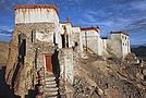
Stay from March 25 to April 16, 2025
· Flight tickets Air India (via Delhi) (via Skyscanner) = 1130 € per person · Planned budget (and respected without too many restrictions and while buying a few small gifts) = 2000 € for the stay for two. Buses, taxis, and entrance fees to various sites represent a budget to consider. Meals are cheap. Drinks like beer/Coke, however, are not cheap and cost the equivalent of a meal. · Exchange rate of the rupee during our stay = 0.0064 € (the exchange rate is almost identical everywhere, including at the airport). · At the airport, purchase of two SIM cards (phone) = 1000 NPR x 2 for 28 days. · Kathmandu: we had booked the hotel upon arrival: Kathmandu Boutique Hotel (+977 015 357 446 – email: booking@kathmanduboutiquehotel.com), very well located in a quiet alley off the street, south of Thamel, a 10-minute walk from Durbar Square. A hotel like Nepal knows how to do, where tall people will have to duck. Night + breakfast = 18 € for two. Very warm welcome, great location, excellent value for money. · Bhaktapur: we had also booked a hotel for the end of our stay because the chance of the year 2025 made the Nepali New Year and Bisket Jatra particularly festive in Bhaktapur: Manju Baha Hotel School (+977 976 7234014 – email: manjubahahotel@gmail.com) located in an old monastery. "A social enterprise transforming an old monastery into a charming hotel, offering professional hospitality training to underprivileged Nepali youth." Night + breakfast = 32 € for two. Beautifully decorated room. Very warm welcome. Don’t miss the Changunarayan site (near Bhaktapur), it’s amazing. And if you’re lucky enough to be in Bhaktapur in mid-April for 3 days, there’s the Bisket Jatra festivities (Newari festival), joyful, noisy, fun, and wild… · Pokhara (hotel recommended by the Kathmandu hotel): Hotel Green Tara, Lakeside, 10th street, set back, quiet (Tel. +977 61 462698 – email: greentara_67@hotmail.com) · Trek permit (Lower Mustang, no need for an agency or guide, permits checked at Ghasa and Jomsom) = 2000 NPR per person (2 ID photos) · Bus Kathmandu/Pokhara and return = 2000 NPR per person · Bus Pokhara/Jomsom, 2 one-way tickets = 2800 NPR. · Taxi: negotiation with a driver we recommend, Vicky (+977 984 075 599). You explain what you want, negotiate the price, and he waits for you during the visit. Very charming, we used him several times. For example: departure from our hotel at 10 AM -> Boudhanath/Pashupatinath/Patan return at 5 PM to the hotel = 6500 NPR – Swayambhunath (round trip) = 1200 NPR · Site prices: https://ntb.gov.np/plan-your-trip/before-you-come/heritage-site-entry-fees o Visitor Pass for Kathmandu Durbar Square (for the duration of the stay, show your visa) = 1000 NPR per person (1 ID photo) o Bhaktapur Durbar Square (old town) = 1800 NPR per person o Patan = 1000 NPR per person o Swayambhu Stupa = 200 NPR per person o Boudha Stupa = 200 NPR per person o Pashupatinath Temple = 1000 NPR per person (interesting to take a guide) o Changunarayan Temple (6 km north of Bhaktapur) = 400 NPR per person o Mountain Museum in Pokhara = 750 NPR per person · E-cigarettes: e-cigarettes are banned in India and confiscated whether they’re in carry-on or checked luggage. On the way there, we had kept them in our carry-on, they were confiscated in Delhi. On the way back, learning from our previous experience, we put them in our checked luggage. Someone came to get us to take them out of our bags and confiscate them… You can find e-cigarettes and products in Kathmandu.
* * *
I’m 74 years old. I went to Nepal in 1982, 1983, and the last time in 1986. I wanted to introduce this beautiful and endearing country to my husband, and it was… now or never. So we decided it was now.
I knew the trek starting from Pokhara: Naudanda/Birethanti/Ghorepani/Tatopani/Kalopani. There was no way I was going to do that trek, especially the 1000-meter staircase to reach Ghorepani… You have to stay humble with age.
Back then, the road didn’t exist. I didn’t consider, with the construction of this road (NH48) along the western bank of the Kali Gandaki, doing a trek along a windy and dusty road. Was there an alternative hiking trail on the eastern bank? No one answered my question on VoyageForum, so I did my research online. And I found this site: "Andrées de Ruiter and Prem Rai - Trekking the Annapurna Circuit, including the new NATT trails that avoid the road - A guide to one of the most beautiful trekking regions in Nepal and the world (2011) - NATT = New Annapurna Trekking Trail".
Phew! A solution was emerging. This circuit from 2011 wasn’t fully marked. The idea was to go from Jomsom to Tatopani, so we needed to make sure the path was well-marked all the way, which we did, and the path exists, marked in red and white!
So, with the walking times information, we built our 8-day circuit:
· Jomsom/Thinigaon · Thinigaon/Chimang · Chimang/Saura · Saura/Kokhetanti · Rest day or, if in good shape: loop to Sekong Lake · Kokhetanti/Jhipra Deurali · Jhipra Deurali/Kopchepani · Kopchepani/Tatopani
It’s a senior trek, after all. So the walking times noted on the sites indicated 3 hours or even 4 hours for the two longest stages. That pace suited us fine.
On March 29, we left Kathmandu (1400m), after visiting the must-see sites, by bus to Pokhara: 200 km and 8.5 hours on a chaotic road under construction. I had a memory of Pokhara where it was the first city where you could see the Himalayan range, especially Machhapuchhare. But the pollution is such, the dust raised by traffic and construction, that no horizon is visible except the first hills around Pokhara.
We stayed 24 hours in Pokhara (820m), and on March 31, we left our luggage at the hotel and set off with our lightest backpacks: change of clothes, toiletries, first aid kit, anti-chafing cream, water bottle, sleeping bag liner, and light shoes for the stages.
We took the bus to Jomsom: 160 km/7.5 hours including stops for bathroom breaks, tea, and lunch. The road is nothing but a chaos of potholes, landslides, construction, dust, rebuilding, and mudslides. In Ghasa, the bus stops, and we’re told we’re at a checkpoint and that the two foreigners in the bus, my husband and I, need to have our permits checked, which takes a few minutes. The driving is rock-and-roll, surprising, and courteous. The drivers have their codes, and on these improbable roads, they’re virtuosos.
We could have chosen the plane, but several reasons dissuaded us: if there’s too much wind, the planes don’t take off; personally, I wasn’t reassured about landing in Jomsom, and this transport has a cost.
We arrived around 2 PM in Jomsom (2720m), and despite the early wake-up, the nearly 8 hours on the bus, and the altitude, we decided to head straight to Thinigaon (2840m). At the Jomsom checkpoint, they told us it was a 30-minute walk. Great! Except we took an hour and a half on an uphill road, bent over to fight a strong wind. But the Himalayan range is there! The Dhaulagiri, the Nilgiri, the Annapurnas as a reward.
In Thinigaon, we found a room at the "Nilgiri View Hotel" run by a didi (big sister in Nepali). From the lodge’s roof, she proudly showed us the different peaks surrounding the village and told us, worried, that it hadn’t snowed here for 3 years. She said there are very few tourists, that the season is rather in September/October/November. It seems there’s not a soul in this village, yet mules pass through the narrow street paved with large flat stones, their bells ringing. We dine at 6 PM and go to bed… Room = 1200 NPR and dinner, breakfast, and drinks = 2560 NPR.
On April 1, we set off at 9 AM, not for Chimang as planned but for Marpha! The didi from the Thinigaon lodge had said it was a 3-hour walk. The first part of this stage is attractive, the mountains are magnificent and imposing, the landscape is superb, there’s no one around, a feeling of being "alone in the world." We follow Dhumbra Tal, this small green lake. The path is a rocky track that climbs steeply. Then, around a hill, we start the big descent that joins the Kali Gandaki. We face the wind head-on, and the violent gusts take our breath away, throw us off balance, and envelop us in dust. We see the road on the other side of the Kali Gandaki. We arrive in the village of Chhairo at 2 PM, completely exhausted and with blistered feet, after 5 hours of walking instead of the planned 3.5 hours.
We’re welcomed by the village nurse, who tells us there’s a lodge in the village. Chhairo is a Tibetan village, a 20-minute walk from Marpha (according to the locals, multiply by 2 or even 3 for us…). We’re going to revise our trek plan and, first of all, spend the night in Chhairo.
The lodge is quite pleasant, and Karma, the hostess, is very friendly. She asks about our plans and suggests we stay in Chhairo the next day, from where we can visit Marpha and also Chimang, a 1-hour walk away, in light mode, meaning without backpacks. She invites us to participate in a village ceremony the next evening.
We immediately accept the proposal, as our feet need rest and the welcome is so warm… Dinner and bed!
We reworked our trek plan, which was too ambitious for our untrained bodies and, let’s face it… no longer in our first youth. In the initial plan, we thought there wouldn’t be too much elevation gain following the Kali Gandaki, but checking the map, we realize there might be significant elevation changes between Sauru and Sirkung. So we plan:
· Tomorrow: visit Marpha (2670m) and Chimang (2744m) · April 3: bus from Chhairo (2700m) to Kalopani (2530m) and continue on foot to Ghasa (2010m) · April 4: Ghasa/Pairataplo (1940m) · April 5: Pairatapla/Gadpar (1580m) · April 6: Gadpar/Narchyang (1510m) · April 7: Narchyang/Tatopani (1190m) · April 8: return to Pokhara.
Normally, it’s all downhill…
April 2, a rest day then… We set off in the morning to explore Marpha. We have to take a temporary bridge because the suspension bridge is closed due to road construction. We join the road and arrive in Marpha, a village famous for its apple orchards, brandy, cider, and apple juice production. This village is magnificent with its stone houses and monastery clinging to the hillside. The road construction spared it. There are people, but very few Western tourists.
We have lunch in Marpha and go back through Chhairo to take the path to Chimang. We cross a fragrant pine forest and find the rocky path; the landscape is splendid. We walk quietly, passing peaceful buffaloes and cows, and arrive at the foot of a stone staircase… 275 steps (which we counted on the way back) leading us to the village of Chimang. Chimang is an isolated Newari village that seems a bit desolate. Despite the slopes, there are crops on every little bit of land. Thankfully, we changed our initial program because there’s no lodge in this village, contrary to what we saw on a map… We wander through the village, which seems very deserted, have coffee in a house from another world, and then head back to Chhairo.
A rest day? = 5 hours of walking!!
Dinner and village ceremony. From what we understand, this ceremony is in honor of the Dalai Lama. Men, women, and children in traditional costumes gather twice a month; they dance, make, and offer small sweet cakes with Tibetan tea (made from tea, yak butter—often rancid—water, and salt). Surprising for first-timers…
Around 10 PM, we leave the ceremony; tomorrow morning, we need to be on the roadside by 7 AM to catch the bus to Kalopani…
This village of Chhairo is very pleasant and welcoming, no tourists, just two motorcyclists who arrived in the evening, one of whom participated in the ceremony and discreetly poured his Tibetan tea outside.
Lodge: "Norsang Tibetan Guesthouse and Restaurant". Total bill for 2 nights, 2 dinners, 2 breakfasts, and drinks = 8000 NPR.
April 3: bus from Chhairo to Kalopani, about 1.5 hours for the 20 km (200 NPR per person). We descend on the right bank of the Kali Gandaki. We find the red and white markings to resume the trek toward Ghasa. We’re in a fragrant pine forest, the Dhaulagiri on one side and the Annapurnas on the other, magnificent, and the path is pleasant and easy. We get a bit lost in this forest, always looking for the markings. Near Lete, two trekkers pass us, and we meet them again a little further on with two very young children, to whom we give the 2 hard-boiled eggs I didn’t eat this morning. They accepted them without hesitation.
We arrive in a village and ask for directions to Ghasa. The young girls point the way. But we come across a forest being logged, trees cut in all directions. We turn back and ask for confirmation. They confirm… But the two young girls catch up with us and clear the way. We have to step over, go around, and cross the felled trees, with no indication at all. Through this pick-up sticks of felled trees, the girls lead us to the top of a stone staircase, indicating that was the path. It’s the only place where we saw rhododendrons in bloom.
We descend the staircase. At the bottom, to the left, there’s a bridge to go toward Choyo, and to the right, a path to Ghasa. We take the right path and join the road. We should normally find the red and white markings, but we don’t… So we continue on the western bank road of the Kali Gandaki.
A little before the village of Misi, we see fumaroles on the opposite bank that seem to come from the ground. We don’t understand. We stopped to eat in the village of Misi (noodle soup = 600 NPR), but it’s hard to communicate with the elderly people running the guesthouse.
We continued on the road, not finding the marked path parallel to the road. Landslides, both on the left and right banks, seem to have taken over the marked routes. It’s a place where the Kali Gandaki gorge narrows, and on the opposite bank, the mountain smokes more and more, and we now hear the crackling of fire. Across from us, the mountain is burning… Our initial plan had us passing on that burning bank right now…
We arrive in Ghasa at 3:30 PM, a 6.5-hour stage but with a 1-hour stop at noon. We’re at the "Florida Guesthouse and Restaurant." From our room, we see the mountain smoking on the other side of the river, and at night, we see the flames. In this village, posters show Himalayan eagles and vultures that seem to be protected species. Indeed, we saw (and heard) 3 eagles circling today.
April 4 – Today, heading to Pairothapla or Kopchepani depending on our feet, accommodation options, and simply our desires.
No more smoke on the mountain this morning. It’s chilly, 7:45 AM, the sky is clear, just a smell of smoke outside.
Price of the lodge = 1000 NPR for the night + 3580 NPR for meals.
We cross Ghasa, which stretches over more than a kilometer. We have a drink at the last guesthouse in the village, and the didi, when she learns our destination, tells us to be careful because the villages we’re going to aren’t safe. Should we distribute our rupees in different pockets? Nah, we kept going.
At the exit of Ghasa, we find the red and white markings and take the suspension bridge to cross the boiling waters of the Kali Gandaki. The passage is impressive because the river is tumultuous. Lots of climbs and even more descents. We’re back on the eastern bank. It’s hot! On the narrow path, we meet a group of buffaloes. Who has the right of way? We decide to stick as close as possible to the rock wall and move forward calmly. The buffaloes look at us, chewing placidly, with no intention of jumping on us. Phew!
After a 5-hour stage (including stops), we arrive in Pairothapla, with hot feet and firm thighs, and decide we won’t go any further. It’s a good thing because there’s a lodge, the most basic so far, but with a great welcome. We have a meal and a short nap. The buffaloes we met on the way belong to this house. They come to drink at the fountain by the path.
Our host, very pleasant, doesn’t know what to do to please us and is very attentive. He wants to chat. He has two children, a 4-year-old girl and a 7-year-old boy. Where do they go to school? Do they go? He tells us that the fires in the mountain are caused by people, but for what reason? We won’t find out, but it’s illegal. From here, we can still see smoke rising in the distance. The wife is a bit less friendly. Corn kernels dry on a woven straw mat on the ground, and the mom sorts them.
From where we are, we overlook the valley and see the road under construction winding along the mountainside on the other bank.
Dinner on the terrace of the house overlooking the path, windbreaker and fleece on: dal bhat chicken for me and chicken curry for my husband: "organic" products, at least local production. There are small vegetable gardens everywhere with all sorts of vegetables.
April 5 – While we’re having breakfast on the terrace of our lodge, 5 porters, straps on their foreheads, heavily loaded, pass by on the path. A few minutes later, a group of 9 people appears. It must be said that since the beginning of our journey, we’ve met very few hikers. Two backpackers in Chhairo, the two hikers near Lete, two female hikers passed us before Pairothapla, a solo female hiker passed us…
The lodge in Pairothapla is called "Bimala Lodge & Thakali Kitchen" – Price for night + 4 meals + 2 breakfasts = 3000 NPR.
The descent toward the Kali Gandaki involves climbs whose steps we didn’t count. Clearly, the landslides on the mountain cause changes to the official ACAP trek marked in red and white, and the marking updates can’t keep up with the pace of these landslides. It’s almost always by chance that we find the markings. Fortunately, we can follow the power line that guides us somewhat.
Drink stop in Kopchepani, the legs are fine, but the feet don’t like being tightly enclosed. A group of trekkers with porters passes on the path. We met buffaloes that we kindly let pass; the path was wide enough, but it was a staircase going up, and we didn’t want to take any risks.
Across, a view of the magnificent Rupse Waterfall on the other bank of the Kali Gandaki, at the bottom, lots of vehicles and people.
Arrival in Gadpar after crossing a rather unwelcoming small village and cultivated gardens between dry stone walls, each better built than the last.
First lodge spotted, first lodge adopted to answer the call of our feet, and a very warm welcome from the owner. Since we hadn’t eaten at noon, we had Tibetan bread/jam. 6-hour stage including 1 hour of stops. Night + dinner + breakfast + drinks = 5060 NPR
April 6 – Today, heading to Narchyang.
For several days, we’ve seen banana trees with their bunches of fruit and even a prickly pear with large fruits ripening.
This stage is quite peaceful and pleasant. We take a suspension bridge to cross a tributary of the Kali Gandaki. While we’re resting for a moment before crossing the bridge, a couple of porters, a man and a woman, arrive and start across the bridge with their wood load in a basket held by a strap on their forehead, making them bend. We set off too… lighter than them.
On the other side of the bridge… a stone staircase, and it climbs steeply. The porter couple didn’t take this staircase; they went right on the path.
At the top of the staircase, we arrive in Narchyang after a 4-hour stage. A magnificent waterfall overlooks the village. We get lost in this fairly large village looking for a lodge. After wandering around for a while, we ask for directions, and an 84-year-old man takes us through the whole village and accompanies us to a very nice lodge run by a woman.
We chat with our hostess, who asks where we’re from and where we’re going. We explain that we want to reach Tatopani the next day and then return to Pokhara. She tells us there are 4x4s going directly to Pokhara and that it would probably be easier than taking a bus that might be full in Tatopani. After a quick consultation, we decide to return to Pokhara the next day by 4x4. She finds us a 4x4 with 2 seats left, departure at 8 AM – 5 hours on the road and 1500 NPR per person. A charming didi who does everything to be pleasant and helpful.
Narchyang community lodge = night + snacks + dinner + breakfast = 3000 NPR.
There you go, our trek ends tomorrow. Many necessary changes and adaptations to our initial trek, but no regrets, it was superb and a great experience that, for my part, I won’t be able to repeat. Always this encounter with the endearing, welcoming, curious, and very kind Nepali people. It was now or never, and we did it!
* * *
In conclusion, 3 full weeks in Nepal is a duration that allows visiting Kathmandu, Patan, and Bhaktapur, enjoying the various sites, and soaking in the atmosphere and urban Nepali life.
The trek, even revised and corrected, allowed us to get close to the impressive Annapurna and Dhaulagiri peaks. One or two acclimatization days might be necessary to get the body in tune with this magical and extraordinary land.

Hi there,
My partner and I are heading to Nepal for 15 days in March—she’s a schoolteacher. We’ll be trekking to Everest Base Camp and then doing the loop via the Gokyo Lakes.
We’d love to set up a fundraiser to donate to a school in Namche, along with visiting the school. It’s something that really matters to us. But it’s been tough to get in touch with a school—any ideas on how to go about this? Thanks!
My partner and I are heading to Nepal for 15 days in March—she’s a schoolteacher. We’ll be trekking to Everest Base Camp and then doing the loop via the Gokyo Lakes.
We’d love to set up a fundraiser to donate to a school in Namche, along with visiting the school. It’s something that really matters to us. But it’s been tough to get in touch with a school—any ideas on how to go about this? Thanks!
Hello my fellow globetrotters, could anyone tell me how to find the French colonial cemetery in Pondicherry? It seems tricky to locate.
Thanks so much for your help! Take care, pace yourselves, and travel far.
Cheers, Régine
Thanks so much for your help! Take care, pace yourselves, and travel far.
Cheers, Régine
I'm looking for a small, not-too-touristy restaurant in Fort Kochi. Do you know one not too far from Jacob Road?
Thanks
Hi there,
My wife and I are getting ready for this tour from March 27 to April 8.
I’d love to know if anyone’s traveled with Salaun Holidays before? How many people are usually in a group? How much cash should we bring?
We’re also unsure about what clothes to pack..... plus sheets and pillowcases?
And if you’ve got any tips to avoid being too bothered by beggars and touts.
Any advice you’ve got would be really helpful.
Thanks in advance!
Hi there,
I’d like to travel to Rajasthan and the Ganges Valley—it’s my first time going on a long-haul trip, and I’m thinking of booking with BTtours from Belgium (or Salaün in France). Has anyone here traveled with this agency before and can share their experience? I was planning to go around November, but some people tell me it might still be pretty cold (around 8°C)—is that true?
Also, what’s the best way to get money there? Can you enter India with cash on you?
Thanks for your help!
Also, what’s the best way to get money there? Can you enter India with cash on you?
Thanks for your help!
hi everyone,
I’m planning a trip to Northern India (Rajasthan, Ganges Valley with Varanasi (Benares)).
My travel agency is offering me two tour operators: Asia with the "Saris and Saddhus" circuit, and Salaun with the "Northern India and the Ganges Valley" circuit. I’ve already traveled to Sri Lanka and Southern India with Asia. The trips went really well.
I don’t know Salaun Holidays. Their circuit seems more comprehensive, with a day of relaxation (16 days on site). Travel with Air France.
Has any member of this forum done the "Northern India and the Ganges Valley" circuit with Salaun? Can I get your feedback on the tour operator Salaun Holidays?
Thanks so much
I’m planning a trip to Northern India (Rajasthan, Ganges Valley with Varanasi (Benares)).
My travel agency is offering me two tour operators: Asia with the "Saris and Saddhus" circuit, and Salaun with the "Northern India and the Ganges Valley" circuit. I’ve already traveled to Sri Lanka and Southern India with Asia. The trips went really well.
I don’t know Salaun Holidays. Their circuit seems more comprehensive, with a day of relaxation (16 days on site). Travel with Air France.
Has any member of this forum done the "Northern India and the Ganges Valley" circuit with Salaun? Can I get your feedback on the tour operator Salaun Holidays?
Thanks so much
Hi there.
We’re heading to India at the end of December for a month.
I planned an itinerary: Delhi, Nawalgarh, Sikar, Jodhpur, Udaipur, Chittaurgarh, Bundi, Jaipur, Bharatpur, and back to Delhi.
Our driver told us it’s not possible because there are no roads.
He’s suggesting the usual tourist circuit, which we don’t want to do.
What do you think of my route?
Any tips?
Thanks, community!
Hello,
We’re a group of 4 looking for a driver and car for our stay in Kerala from November 22 to December 12, 2025. We’ve already planned an itinerary starting from Cochin.
We’ve traveled with a driver before during our trip to Rajasthan.
Thanks for your replies!
Yves
Hi everyone,
we’re heading to Tamil Nadu and Kerala at the start of the year for 30 days. We did Rajasthan 12 years ago, but things change fast.
I’ve read that to get a SIM card, you have to buy it at a shop and then go to the operator to get a number; you’d also need an Indian mobile number. Has anyone here had recent experience with this?
For buses and trains, do you need to book them well in advance?
Any tips are welcome—thanks in advance!
Happy holidays to all,
Philippe
Hi everyone! 🙂
My partner (who’s a teacher—hence the summer holidays) and I are heading to Eastern India for 23 days in July. This is my 5th trip to India, but her first.
We fly into Delhi on July 7th and leave from Delhi on the 23rd (since our flight to Kolkata arrived late at night, and I wanted to show Agra and Varanasi to my partner).
We love getting off the beaten track and meeting people, so we’ll mostly be taking the train.
Here’s what we’re planning:
- **DELHI**: 1 night on the way (short because the plane is supposed to land at 01:55), then we take the train at 13:00 - **GWALIOR**: 3 nights, including a day trip to **AGRA** by train to see the Taj Mahal and the Red Fort (I find Agra too touristy to stay overnight). Otherwise, in Gwalior, the Fort, the temples, the Man Mandir Palace, and the Jai Vilas Palace if we have time. - **ORCHHA**: 2 nights... *maybe skip this to spend more time in VARANASI?* - **VARANASI**: overnight train + 3 nights, the Ghats, temples... maybe a day trip to **SARNATH**. - **KOLKATA**: overnight train + 3 nights. Maybe a countryside excursion to the ashram in Channa. *- Here we’re hesitating over 2 nights: either 2 nights in **SHANTINIKETAN** with a visit to **CHANNA** on the way, or a 2-day excursion to the **SUNDARBAN** nature park. But is it worth it in July during the monsoon?* - **PURI**: overnight train + 4 nights. *We’re planning to do everything from Puri, as it seems nicer than staying in BHUBANESWAR. What do you think?* Visit **KONARK** and **CHILIKA LAKE**. *Is it worth visiting Chilika Lake this season? Another question: can you swim in Puri, or is it too dangerous (waves)?* - Train to **BHUBANESWAR**, then a flight from BHUBANESWAR to **DELHI**, - 2 nights in **DELHI**, visiting Jama Masjid, and *either Humayun’s Tomb, Safdarjung’s Tomb, or Qutb Minar.*
Back to Paris. Total: 23 nights.
What do you think of these choices? What about the options we’re still unsure about *(in bold/italics)*? Thanks so much! 🙂
We fly into Delhi on July 7th and leave from Delhi on the 23rd (since our flight to Kolkata arrived late at night, and I wanted to show Agra and Varanasi to my partner).
We love getting off the beaten track and meeting people, so we’ll mostly be taking the train.
Here’s what we’re planning:
- **DELHI**: 1 night on the way (short because the plane is supposed to land at 01:55), then we take the train at 13:00 - **GWALIOR**: 3 nights, including a day trip to **AGRA** by train to see the Taj Mahal and the Red Fort (I find Agra too touristy to stay overnight). Otherwise, in Gwalior, the Fort, the temples, the Man Mandir Palace, and the Jai Vilas Palace if we have time. - **ORCHHA**: 2 nights... *maybe skip this to spend more time in VARANASI?* - **VARANASI**: overnight train + 3 nights, the Ghats, temples... maybe a day trip to **SARNATH**. - **KOLKATA**: overnight train + 3 nights. Maybe a countryside excursion to the ashram in Channa. *- Here we’re hesitating over 2 nights: either 2 nights in **SHANTINIKETAN** with a visit to **CHANNA** on the way, or a 2-day excursion to the **SUNDARBAN** nature park. But is it worth it in July during the monsoon?* - **PURI**: overnight train + 4 nights. *We’re planning to do everything from Puri, as it seems nicer than staying in BHUBANESWAR. What do you think?* Visit **KONARK** and **CHILIKA LAKE**. *Is it worth visiting Chilika Lake this season? Another question: can you swim in Puri, or is it too dangerous (waves)?* - Train to **BHUBANESWAR**, then a flight from BHUBANESWAR to **DELHI**, - 2 nights in **DELHI**, visiting Jama Masjid, and *either Humayun’s Tomb, Safdarjung’s Tomb, or Qutb Minar.*
Back to Paris. Total: 23 nights.
What do you think of these choices? What about the options we’re still unsure about *(in bold/italics)*? Thanks so much! 🙂
hi everyone, I’m putting together an itinerary for Sri Lanka in September 2026, so I’m focusing on the east side of the island because of the monsoon on the west coast:
Day 1 Kandy: botanical garden, fruit and vegetable market, traditional dance show
Day 2 Kandy-Ella train
Day 3-4 Kumana NP or Lunugamvehera Block 6+5
Day 5-6 Komari / Pottuvi lagoon safari
Day 7 head up the east coast along the beaches to reach Wasgamuwa NP
Day 8 Wasgamuwa NP early morning safari, then Polonnaruwa (temple and palace)
Day 9-10 Sigiriya Lion’s Rock and Dambulla, cave temple
Day 11-12 Wilpattu NP early morning safari, then late afternoon
Day 13-14 Kalpitiya, snorkeling and chilling
Day 15 return to Colombo
Thanks for sharing your thoughts on whether this route is doable—we’ll be traveling with a driver-guide.
Feel free to mention any great tips or good homestay experiences you’ve had, since we prefer those.
Hi everyone, Kerala experts (especially Marien!)
In January, I’m planning another trip to Kerala. We’ll arrive in Kochi and travel up the coast by train to Gokarna.
So I’m reaching out to ask if it’s worth stopping for a few days in any of the following spots (not all, of course—just one or two that are really worth it...). From what I’ve seen, few Western tourists stop along this coast, given how little info there is about it:
Mahe, Thalassery, Taliparamba, Nileshwar, Bekal, Kasaragod
I’m not mentioning Kannur because we’ve already been there, specifically Thottada Beach, and we’re familiar with the southern destinations (Trivandrum, Kovalam, etc.).
Thanks for your replies!
Anne
Hello,
My husband and I usually spend a month in January/February in southern India. We end our trip in Gokarna and fly back from Vasco de Gama Airport in Dabolim. So, it might make sense to spend a few days in a nice, quiet spot in southern Goa. Do you have any recommendations?
Thanks
Hi there,
I’d like to head to Upper Dolpo in September/October 2026.
Does anyone know the current state of the roads in the area?
Specifically for getting from Saldang to Dho Tarap.
Also, what do you think about the weather between September 20th and October 20th?
Any tips would be much appreciated.
I’ve already checked out the info on Martinpierre’s site—it’s super detailed about the region, but the details are a bit outdated.
Thanks in advance for your advice.
Thierry