salut a tous, alors voila je n'arrive pas a me decider et me rassuer, j'aimerai faire dans le sens de la descente la shaefer trail + potash road ou la long canyon...avec une chavy tahoe et j'hesite sur le temps que cela prend et les risques pour la voiture n'etant pas un as de la conduite ni et surtout du changement de roue....
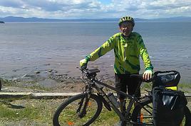
je me disait aussi que ce serait meme plus sympa de faire la descente a velo....oui mais alors ou trouver les velo? car il faudrait que qqn nous depose au debut de shaefer trail et nous reprenne soit a la fin de potash, soit on rentre a velo sur moab.....nous somme 4, donc 2 conducteurs...on aurait aussi pu imaginer louer 2 velo, les mettre dans la chevy tahoe et descendre velo+ voiture et s'echanger quand necessaire.....
qui connais ? qui peut donner des infos? merci ( c'est pour mi septembre 2014.....)
Nous avons fait la Shafer Trail et la Potash Road en juin 2014.
La Shafer Trail est impressionnante et génère une bonne dose d'adrénaline pendant ses quelques miles et ses virages en épingle.
Nous l'avons fait en Ford expedition en position 4X4 et la descente à vitesse réduite est relativement facile et roulante, avec la prudence qui s'impose, bien sûr, et quel plaisir vous allez éprouver quand vous aller réaliser que vous l'avez fait !!!
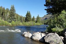
Plus bas, la Potash Road présente des endroits assez accidentés où le 4X4 prend toute sa valeur, mais si vous aimez un pilotage un peu plus sportif, vous allez être servis.
Il faut compter entre 1h30-2h pour rejoindre Moab mais en fait cela dépendra des arrêts photos que vous ferez, il y a des points de vue du Colorado très sympas.
Avec un Tahoe, vous n'aurez pas de problème, nous en avions eu un pour notre trip en 2010, nous avions fait quelques pistes très confortablement avec lui, vérifiez tout de même votre roue de secours avant de partir ....
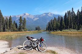
Beaucoup de vététistes descendent et mixer 4X4 et VTT est une idée splendide et originale.
Allez-y foncez (mais pas trop tout de même) et n'hésitez pas à poser d'autres questions
louer 2 VTT et se "relayer" est une bonne solution qui évite les Pb d'intendance !
En + tu peux déjà "la faire" sur google...maps, valeurs ci-dessous (puis Earth...):
- 5,2miles/23mn depuis la route de Canyonland jusque la jonction vers Musselman Arch (avec en +3,4miles/14mn pour y arriver).
- remonter les 3,4miles/+14mn puis attaquer la Potash pour 8miles/36mn jusqu'aux bassins de potasse.
- de là encore 6miles/24mn pour atteindre la route goudronnée 279 (2miles sur cette route pour voir, à gauche Jug Handle Arch...).
il restera encore 20miles/27mn pour être à Moab ! et si tu en a encore sous le pied, le parking de Corona Arch te tends les bras...il est sur ta route !
Merci à vous 2 pour les infos. En faite j ai loué la catégorie chevy tahoe, pas sur que j ai bien celle la. De plus je ne suis pas sur que ce sera un 4x4... Ça devrait normalement.... Je stress car jamais changer de roue de ma vie donc zéro expériences... J avais un Toyota rav 4 de 2000 et je mettais un vélo de course dans le coffre, .... Pour la taohe je n aurai pas de porte vélo..... Comment faire...??? J avAis fait en 2013 la cottonwood canyon road vers page/bryce sans mettre le 4x4 d un ford explorer ( d ailleur c est con comme question mais le 4x4 est un bouton ou sur les boîtes à vitesse auto?) vous l aurez compris je suis une miss.... Sorry :)
"5,2miles/23mn depuis la route de Canyonland jusque la jonction vers Musselman Arch
attaquer la Potash pour 8miles/36mn jusqu'aux bassins de potasse.
de là encore 6miles/24mn pour atteindre la route goudronnée 279
il restera encore 20miles/27mn pour être à Moab ! "
Soit, si je compte bien, 110 min, donc moins de 2 heures😮
A croire que ces pistes sont devenus de vrais boulevards bien lisses depuis 2011(ce que je ne pense pas, à la lecture de récents carnets) , et que google maps a revu ses temps de route à la baisse😮
Voici ce que moi, j'avais inscrit sur mon RB
Shafer Trail(5mi/30 min)
+ petit détour sur la White Rim Road (3,2 mi/20 min jusqu’à Musselman Arch) , si SUV 4WD high clerance)
+ Potash Road (13mi/1h30)
+ Route goudronnée 279, longeant le Colorado (15mi/1h00)
Soit 3 heures (sans le détour > Musselman Arch), sans compter les haltes... et c'est bien le temps que ns avions mis (en 2009 et en 2011)... et même plus en additionnant les arrêts photos... et pourtant ns avions en plus un SUV haut sur pattes permettant de déjouer les "pièges" de la Potash Road plus facilement qu'avec une simple berline
Ouest USA 2009 https://voyageforum.com/v.f?post=2800143#2800143
5ème trip USA, 09/2013 https://voyageforum.com/v.f?post=6186946#6186946
"La Shafer Trail est impressionnante et génère une bonne dose d'adrénaline pendant ses quelques miles et ses virages en épingle"
Faut qd même pas exagérer... Cette piste est impressionnante vue d'en haut, mais une fois qu'on est en train de la descendre, elle est extrêmement facile et ne génère aucune peur.
(c'est le même effet qu'une piste de ski qui parait tjs bien plus pentue vue de loin)
"Nous l'avons fait en Ford expedition en position 4X4"
Là aussi, à moins qu'il n'y ait eu un orage, la Shaffer trail ne nécessite aucune fonction 4x4
D'ailleurs, peu de pistes ds l'ouest américain ne nécessite la fonction 4x4 (si le terrain est sec).
C'est surtout la high clerance qui est importante (pour éviter de frotter les bas de caisse ds les trous et sur les gros cailloux)
"Il faut compter entre 1h30-2h pour rejoindre Moab"
Je ne crois pas du tout qu'on puisse enchainer Shafer trail + Potash Rd + rte 279 jusque Moab en aussi peu de temps (voir explication ci-dessus), même sans s'arrêter (ce qui serait aussi une aberration)
Ouest USA 2009 https://voyageforum.com/v.f?post=2800143#2800143
5ème trip USA, 09/2013 https://voyageforum.com/v.f?post=6186946#6186946
Pour des infos concernant la location de vélos à Moab (avec ou non pause-reprise à l'endroit voulu) , contacte les vieux de la vieille: Max68, LeSpartiate et Trois14 (voir son expérience racontée ici http://voyageforum.com/v.f?post=6589785#6589785)
Ouest USA 2009 https://voyageforum.com/v.f?post=2800143#2800143
5ème trip USA, 09/2013 https://voyageforum.com/v.f?post=6186946#6186946
Bien le Bonjour ma chère Jacqueline du plat pays (qui est le mien...aussi !),
Mes propos ci-dessus sont à utiliser avec modération... ce ne sont "que" des temps de roulage donnés par google !!
il FAUT bien sûr, ajouter les pauses photos et franchissements éventuels, la contemplation... un petit pique-nique sous l'arche, l'équipement du 2ème lot de VVTistes, etc....
Donc en savourant le tout, disons 4h00/4h30, temps auquel il faudra ajouter la montée depuis Moab, et la rando de Corona Arch... donc une bien belle journée !!
"La Shafer Trail est impressionnante et génère une bonne dose d'adrénaline pendant ses quelques miles et ses virages en épingle"
Faut qd même pas exagérer... Cette piste est impressionnante vue d'en haut, mais une fois qu'on est en train de la descendre, elle est extrêmement facile et ne génère aucune peur.
(c'est le même effet qu'une piste de ski qui parait tjs bien plus pentue vue de loin)
Nous devons être très impressionnables ou non blasés par les paysages accidentés de cette magnifique région. Il est vrai que le premier Km est le plus impressionnant et qu'après on prend confiance ....
"Nous l'avons fait en Ford expedition en position 4X4"
Là aussi, à moins qu'il n'y ait eu un orage, la Shaffer trail ne nécessite aucune fonction 4x4
D'ailleurs, peu de pistes ds l'ouest américain ne nécessite la fonction 4x4 (si le terrain est sec).
C'est surtout la high clerance qui est importante (pour éviter de frotter les bas de caisse ds les trous et sur les gros cailloux)
Oui, c'est vrai, il n'y a pas nécessité si le temps est sec, mais c'est sacrément plus sécurisant et en théorie (dixit les rangers) cette piste n'est autorisée qu'au 4WD.
"Il faut compter entre 1h30-2h pour rejoindre Moab"
Je ne crois pas du tout qu'on puisse enchainer Shafer trail + Potash Rd + rte 279 jusque Moab en aussi peu de temps (voir explication ci-dessus), même sans s'arrêter (ce qui serait aussi une aberration)
Oui, erreur de ma part, nous avons dû mettre 3 bonnes heures ...
Ne stressez pas, vous serez en vacances dans un endroit sensationnel, c'est super !
Il faut bien penser que 4X4 ou pas, Shafer trail ou route goudronnée, une crevaison est toujours possible, mais elle est statistiquement improbable. La preuve si vous n'avez jamais changé de roue de votre vie, c'est que vous n'avez jamais crevé, ou alors qu'à chaque fois un gentil garçon vous a dépanné. Moi-même, je ne me souviens même pas de ma dernière crevaison ...
Vous êtes 4 filles ou bien y-a-t-il des garçons avec vous ? çà peut tout changer !
Pour définitivement vous rassurer, vous devez savoir que les Américains sont très sympas et serviables et même sur la Shafer vous pourriez recevoir un coup de main de leur part.
La position 4X4 se met grâce à un gros bouton à crans, situé généralement sous le tableau de bord (sur le Ford Expedition, il y avait la position 2X4, 4X4 high et 2 autres dont je ne me souviens pas).
Je ne suis pas sûr que les VTT tiendront dans votre véhicule, mais il y a de grandes chances que votre loueur vous trouve une solution, et comme vous le conseille Bastinj, rapprochez-vous des vieux de la vieille, qui ont vécus ces expériences.
Nous avons fait le Shaffer trail il y a 3 semaines. J'ai prévu un petit compte rendu de notre voyage sur VF (à force d'utiliser celui des autres, je me suis dit qu'il faudrait que je participe aussi !!!). En attendant, voici mes remarques sur cette route faite avec un Ford Edge:
- La route est plus impressionnante vue d'en haut que lorsqu'on est dessus! Nous avons le vertige, mais ça s'est bien passé!
- La route est impressionnante mais sans risques du début jusque l'embranchement de Potash Road. Ensuite, elle est moins impressionnante mais nécessite vigilance car il y a quelques partie cassantes.
- Ca limite notre performance (grande pour nous car nous étions très stressés), mais je dois dire que sur la partie en descente, j'ai laissé passer un camion de gravats (il y avait des travaux sur la route de Musslin Arch qui d'ailleurs était fermée) qui devait faire des manœuvres à certains virages !!! Preuve que ce n'est quand même pas "le salaire de la peur". Et un 4x4 pick-up (sans doute un employé sur ces travaux) qui remontait attelant une caravane.
Donc, oui, c'est impressionnant, mais non, ce n'est pas insurmontable !
J'ai noté nos temps de roulage (à vitesse réduite et sécurité maxi). C'est donc du réel vécu, incluant les poses photo et "méditation" dans ces paysages d'exception :
- De l'embranchement après le Visitor Center jusque la bifurcation de Potash Road : 5,5 miles et 50 mn
- Embranchement Potash Road jusque la route bitumée pour rejoindre Moab : 13 miles - 1h20.
Dans la première partie, afin d'éviter de faire chauffer les freins, j'étais en position S (ou 1-2-3 selon le type de véhicule) sur la boite auto pour utiliser au max le train moteur.
J'ai descendu 3 fois le Shafer Trail ces dernières années,
raconté dans mes carnets de voyage 2009,2010 et 2013 (page 2)
avec des SUV non 4x4.
Ce n'est pas la descente qui pose des problèmes, mais la piste après,
surtout l'an dernier après les orages.
Bern
USA 2018 - Arizona, chez les indiens... https://voyageforum.com/v.f?post=9061068;#9061068
USA 2014 – Là où vous n'aviez pas pensé aller https://voyageforum.com/v.f?post=6769327;#6769327
USA 2012 "Au long du Rio Grande" https://voyageforum.com/v.f?post=5290732;#5290732
Depuis 20 ans, 15 circuits dans l’ouest, J’ai fait 5 fois le Shaefer trail avec une voiture normale, seule en 2011 et 2012 la piste était trop défoncer par les 4x4 2 km après deaht point horse , impossible de passer avec une voiture basse de caisse mais possible avec un SUV haut de caisse. Si vous louer par ALAMO choix entre 30 voitures + ou – SUV ou 4X4 520 € pour 22 jours . En vélo prévoir un kit de réparation, pompe à vélo beaucoup de crevaisons. il est possible de metre les velos dans le 4x4 ou SUV en enlevant la roue avant des velos
Je vous conseil de partir de Moab au lever du soleil , faire Coronado Arch, puis la piste, mulseman arch et la monter sur sky island , vers 16 h vous aurez le temps de faire delicate arch ou le state park de deaht point horse.
merci a tous pour vos messages,
alors on est 4, 1 seule fille pour 3 messieurs, qui 2/3 ne savent pas conduire et le dernier sait changer une roue, ouf on est sauvé!!!!
j'ai pris contact avec des loueurs de velo et des "taxi de velo" spécialisé dans le drop on drop off de velo, on verras la réponse...
sinon persone n'a parlé de la long canyon road ( entre dead horse et moab) car elle me fait aussi envie, mais je pense pas pouvoir faire les 2, ou alors 1 jours l'une, un jour l'autre.....
d'ailler en venant de Moab est il envisageable de faire en une journée canyonlands et dead horse ( sans hike, juste les points en voitures et arrets) en combiant la monté ou descente de shaefer+postash?????
potash est-ce tres beau? ou peut on juste descendre la shafer pour la remonter ( en voiture)....bien que je me dis que ca doit etre con quand meme.....
merci
en venant de Moab est il envisageable de faire en une journée canyonlands et dead horse ( sans hike, juste les points en voitures et arrets) en combiant la monté ou descente de shaefer+postash?????
Voici notre timing :
- Moab (départ hôtel 7h00) - Dead Horse Bend avec visites - route jusqu'au Visitor Center de Island In The Sky : 2h45
- Visite de tous les spots (sans randonner) de Canyonsland IITS - Retour jusqu'au niveau de Shaffer Trail: 4h
- Shaffer Trail + Potash : 2h10, comme déjà indiqué.
Il y a de beaux paysages/points de vue sur Potash, ce serait dommage de ne pas la faire.
Ca nous a laissé le temps de faire Corona Arch (presque 2h de parking à parking : l'arche est assez loin par un chemin quand même fatiguant après une journée chargée) sur la route de retour en fin de journée pour Moab.
Voir mon carnet ci-dessous (le 2/07/2011): Long canyon était praticable avec un 4x4 high clearance (très important pour cette piste)
Voir aussi le carnet de Max68 qui y est passé 15 jours + tard que moi; la piste était devenue impraticable suite aux orages; du coup, il l'a faite en vélo (voir son carnet http://retourdelouest2.blogspot.com)
Si tu l'avais contacté comme je te l'ai suggéré hier, tu l'aurais appris😛
Moralité: tjs se renseigner au visitor center de Island in the Sky pour connaitre l'état de cette piste qui n'est jamais facile
J’ai fait le long canyon a Moab en octobre il faut vraiment un 4x4haut caisse et par choc avant dégager , Onion creek a faire absolument sur la route 128.A faire aussi en 4x4 White poket endroit encore accessible sans permis entre Moab et kanab
bon, alors merci pour les video, cette fois on est bon.
je realise que l'annee passe j'ai pris des montée et descente plus pentue ( cotoonwood canyon road) dirait-on et aussi plus caillouteuse/troué sur wills creek canyon vers kodachrome, donc en voyant les video, ca me parait assez easy, faut juste avoir la bonne voiture ( un SUV high clearance avec 4x4 si route pas seche) et y aller doucement par endroit, mais tu es passé easy......je trouve meme que quand on descend a monument valley ( le bout qui descend pas la piste) c'est bien plus defoncé.....)
donc j'ai l'intention de faire:
moab-canyonlands island in the sky : les points de vues
descente shaefer trail/potash voiture/velo 2....retour moab
et jour suivant:
moab-dead horse au lever du soleil//descente long canyon (how long???) avec velo 2 aussi...retout moab et apres midi depart sur grand junction.....merci a tous
encore besoin de connaitre le temps estimé pour descendre long canyon...svp
J'ai descendu 3 fois le Shafer Trail ces dernières années,
raconté dans mes carnets de voyage 2009,2010 et 2013 (page 2)
avec des SUV non 4x4.
Ce n'est pas la descente qui pose des problèmes, mais la piste après,
surtout l'an dernier après les orages.
Bern
J'adhère parfaitement à ce message
Nous l'avions fait il y a deux semaines
Une petite galère l'aprés descente (route defoncée)
Une 4x4, haute garde au sol, et une bonne dose de prudence
On peut se faire plaisir (moi au bout de 2h) il n 'y avait plus de plaisir
J'ai légèrement touché par deux fois (Jeep Cherokee : le petit)
La visite de Corona Arch pat la suite nous a fait du bien
Pour mon petit Trip de Mai Juin 2018 - J'envisage une petite balade VTT à Moab J'y suis passé il y a très longtemps quand j'étais jeune, beau et intelligent...…
Je planifie mon prochain voyage aux états unis qui devra notamment me mener dans la région de Moab et je voudrais savoir si l'un (e) d'entre vous a déjà…
Je suis en train de planifier un voyage à l'ouest américain pour 2017 Et j'ai deux petites questions pour le Grand Canyon: j'aimerai savoir combien de temps,…
Ça y est je viens de me recoller à mon circuit Denver Denver de septembre et sérieusement cette fois j’espère. Après notre première nuit à Idaho Spring notre…
Hello! The itinerary is pretty much set for August 2026. Yeah, I know it’s gonna be *super* hot. But it’s the only time we can get away.
So, here’s the plan: Montpellier-CDG-Dallas.
Stay from July 31 to August 26, 2026:
Car rental – check,
Hotels – check,
Itinerary – almost check,
Photo gear – check,
Budget – check, 🤪
Meal planning – meh, we’ll see...
Walmart, of course, for the cooler when we arrive.
And now, without too much detail...
Fort Worth:
The Longhorns and the Stockyards;
JR’s ranch (for the missus);
Medal of Honor Museum – Arlington.
Houston and NASA Space Center:
See the Gulf of Mexico/America.
San Antonio and the missions.
Fort Stockton for an overnight stop.
El Paso via Guadalupe Mountains:
El Paso and White Sands.
Tucson and the Pima Air & Space Museum:
Tombstone, Bisbee.
Phoenix:
Still working on the program.
Sedona:
Round trip around the area via Flagstaff and Williams, or the Grand Canyon (already done) – we’ll decide on the spot.
Albuquerque:
Santa Fe,
Turquoise Trail,
Los Alamos.
Amarillo via Route 66:
Old Route 66 in the city;
Big Texas Ranch Steak 😏.
Dallas:
JFK Museum;
Perot Museum;
West End district.
And through it all – the road, the road, and more road!!!
We’ll adapt day by day based on our mental and physical state (we’re not exactly spring chickens).
Hello everyone! Really damaged due to flooding caused by runoff after forest fires (a total mess!), does anyone in this friendly forum have any updates on the Apache Trail between Apache Junction and Roosevelt Dam? Is there still a section of the road that’s tough to navigate?
We're leaving at the end of June and will be driving the route between Buffalo and Cody. We’ve already booked our accommodations and a rodeo in Cody, but during the day, we’ll be driving between the two and I’m unsure about the itinerary.
Which route do you think is the most pleasant, interesting, or scenic between:
- The northern route via Highway 14 with Sheridan, Lowell, etc.
- The southern route with Highways 16/20/14, passing by Loaf Mountain Overlook, Powder River Pass, Ten Sleep Canyon...
We’ll be in a car, so we should be able to drive on any road.
Thanks for your input!
I’m almost done planning our September road trip. After our 3-night visit to Sequoia, we’ll have a stopover night in Coalinga (to break up the drive). We’ll be staying two nights in Monterey and would like to stop along the way to visit one side of Pinnacles National Park. We’re torn between the West entrance and the East entrance, and we’d like to do a short hike of no more than 2 hours since we don’t want to arrive too late in Monterey.
This park is split into two distinct zones with no connection between them, and the mileage from Coalinga to Monterey is pretty much the same for both. Which area do you recommend visiting—east or west? And which route is the most scenic?
I’ve spotted two short hikes:
- East: Moses Spring to Rim Trail Loop
- West: Balconies Cliffs Cave Loop
Has anyone been there, or do you have another hike to suggest?
Thanks in advance, and have a great afternoon!
Marcalamar 🙂
After our first trip as a young couple to the West in 2007 (yes, that doesn’t make us any younger!), we’re planning to go back in 2028, but this time as a family of four! (We have two boys who’ll be 5½ and 13 years old in the summer of 2028.)
Our plan is to combine a few big cities (SF and LA, maybe San Diego) with national parks and state parks, mostly!
Ideally, we’d like to leave at the end of June and head back to France around July 19–20, so we can enjoy the first week of the Olympic Games in Los Angeles.
Since we already did the "loop" in 2007, there are must-see places we absolutely want to revisit—and especially share with our kids: Bryce Canyon, Yosemite, and above all, the Grand Canyon, which is still the most incredible thing I’ve ever seen on Earth!
On the other hand, some places didn’t leave a big impression on us for various reasons, so we’re not making them a priority: Antelope Canyon, Monument Valley, for example.
We’re planning ahead, but might as well be smart about it😏
Do you have any tips for a fun and doable itinerary over about 20–25 days with kids, without rushing?
Hi everyone! 🙂
Just a quick question about King Canyon and Sequoia National Park.
Before our night in Miramonte, we plan to visit King Canyon. The next stop will be two nights in Three Rivers to explore Sequoia National Park. I wanted to go all the way to Roaring River Falls on the King Canyon Scenic Byway and then turn back to head to Miramonte. Since we’re coming from Oakhurst, Google Maps says it’s 300 km and 5 hours of driving. Since we also want to hike to see the sequoias (Big Stump Area and Grand Grove) before tackling the King Canyon Scenic Byway, the timing’s going to be tight. How far do you recommend going before turning back to miss as few points of interest as possible on the King Canyon Scenic Byway? Thanks for your advice, and have a great evening!
Marcalamar 🙂
Hi everyone!
After years of hoping, waiting, planning, then changing, saving, and searching for the best possible route... we're FINALLY off this summer for a 5-week road trip in the West.
I had planned a trip to Colorado in 2021 but canceled due to COVID, so with time passing and my eldest’s high school graduation approaching fast, I figured it was now or never!
Anyway, the itinerary has been modified and extended to please everyone (I’m no longer the only one making decisions!!)
Here’s our final route:
Day 1 - 7/12/2026 - Brussels / Los Angeles
Day 2 - 7/13/2026 - Los Angeles
Day 3 - 7/14/2026 - Los Angeles
Day 4 - 7/15/2026 - Los Angeles
Day 5 - 7/16/2026 - Los Angeles
Day 6 - 7/17/2026 - Los Angeles / Kingman
Day 7 - 7/18/2026 - Kingman / Grand Canyon
Day 8 - 7/19/2026 - Grand Canyon / Page
Day 9 - 7/20/2026 - Page
Day 10 - 7/21/2026 - Page / Monument Valley
Day 11 - 7/22/2026 - Monument Valley / Durango
Day 12 - 7/23/2026 - Durango
Day 13 - 7/24/2026 - Durango
Day 14 - 7/25/2026 - Durango
Day 15 - 7/26/2026 - Durango / Glenwood Springs
Day 16 - 7/27/2026 - Glenwood Springs
Day 17 - 7/28/2026 - Glenwood Springs / Moab
Day 18 - 7/29/2026 - Moab
Day 19 - 7/30/2026 - Moab
Day 20 - 7/31/2026 - Moab
Day 21 - 8/1/2026 - Moab
Day 22 - 8/2/2026 - Moab / Vernal
Day 23 - 8/3/2026 - Vernal / Grand Teton
Day 24 - 8/4/2026 - Grand Teton
Day 25 - 8/5/2026 - Grand Teton / Cody
Day 26 - 8/6/2026 - Cody / Yellowstone
Day 27 - 8/7/2026 - Yellowstone
Day 28 - 8/8/2026 - Yellowstone
Day 29 - 8/9/2026 - Yellowstone
Day 30 - 8/10/2026 - Yellowstone / Salt Lake City
Day 31 - 8/11/2026 - Salt Lake City / Bryce Canyon
Day 32 - 8/12/2026 - Bryce Canyon / Zion
Day 33 - 8/13/2026 - Zion
Day 34 - 8/14/2026 - Zion
Day 35 - 8/15/2026 - Zion / Las Vegas
Day 36 - 8/16/2026 - Las Vegas
Day 37 - 8/17/2026 - Las Vegas / Los Angeles
Day 38 - 8/18/2026 - Los Angeles
Day 39 - 8/19/2026 - Los Angeles / Brussels
Day 40 - 8/20/2026 - Brussels / Home
We’ll be alternating between house swaps, motels, and campgrounds. I’ve booked all the accommodations (except the campground at Bryce since sunset bookings open only 14 days in advance) and the first activities, as well as the most touristy ones.
I’m currently putting together my day-by-day roadbook and having some trouble planning certain days, like in LA or Las Vegas. Choosing hikes isn’t easy either—it’s tough to decide!
We’re really excited but could definitely use your help with choices and optimizations!!
Hello.
I’d like to travel along I-15N from San Diego to Las Vegas with my mom, who’s 67. We’ve explored Northern California and the California Coast over the past two years and now want to continue through the desert.
There are several attractions along the way:
- Mormon Rocks
- Desert Discovery Center and visit the Old Woman meteorite
- Joshua Tree National Park
- Mojave Desert
- Mojave National Preserve
- Anza-Borrego Desert State Park
- Silverwood Lake
My mom has back issues that prevent her from hiking or walking on trails with elevation changes. Is it possible to visit these places by car, or are the routes flat enough?
I’d love for her to experience the desert with an itinerary adapted to her condition. I’m also open to other points of interest that aren’t mentioned. We have 3-4 days for the trip, so we’re not in a rush—just want to explore.
I’d love to take a road trip and visit Nova Scotia. I’d appreciate some info on the best cities to see and the most interesting spots. The trip should last about 10 to 15 days, staying in hotels or motels. Thanks in advance!
We’re being relocated to Saint Pierre and Miquelon.
We’ll be taking the flight from Nantes to Montreal and then from Montreal to Saint Pierre.
Could you recommend a hotel near the departure terminal that allows dogs?
Hi,
My 16-year-old son is flying to Grand Rapids with other kids his age. There’s a layover in Detroit. There’s no unaccompanied minor service available. Is it pretty easy to navigate Detroit Airport to catch the connecting flight to Grand Rapids (domestic flight)? There are several of them who speak English well.
Thanks for your replies,
Good evening, everyone! 🙂
Just a few last questions to wrap up our Lake Tahoe visit plans.
**Parking:**
We’d like to walk to Eagle Falls and then Eagle Lake. I’ve spotted two parking lots that seem close to each other and give access to the trailhead. Where and how do we pay for entry to Emerald Bay State Park and Inspiration Point?
**Viewpoints on the East Side:**
Are most of the viewpoints (Balancing Rock, Granite Cave, Bonsai Rock, etc.) right by the road, or do you have to hike to reach them?
**Donner Memorial State Park:**
Is it worth making a detour to Truckee to visit this park and the Truckee historic downtown?
Hi there. I'm shocked by the price of the Upper Antelope Canyon tour—$175 for less than an hour… You might say, "if you can’t afford it…" But the real question is whether it’s really worth it, because $350 for two makes me feel like I’m getting ripped off. For those who’ve done both Lower and Upper, can you tell me if the price difference is really justified? Thanks
Hi everyone! 🙂
As you can see, we're heading back from September 6th to the 27th.
Everything’s booked for September—flights, accommodations, and the car. As I plan, I’ll be asking the experts for help. This is our second trip to California, but most of the stops are new to us.
We’ll start directly from San Francisco to our first overnight stop, Davis, before heading to Lassen Volcanic Park for 4 nights. Our flight lands at 12:50 PM.
Here’s our itinerary:
Day 1: Davis – overnight stop
Day 2: Red Bluff – exploring Lassen Volcanic Park (scenic drive to Lake Helen)
Day 3: Susanville – scenic drive through the park via the South Entrance, points of interest, and hikes
Day 4: Susanville – Cinder Cone and Painted Dunes hike
Day 5: Susanville – Warner Valley (hikes)
Day 6: South Lake Tahoe
Day 7: South Lake Tahoe
Day 8: Mammoth Lake
Day 9: Mammoth Lake
Day 10: El Portal via Tioga Road
Day 11: El Portal
Day 12: El Portal
Day 13: Oakhurst
Day 14: Miramonte
Day 15: Three Rivers
Day 16: Three Rivers
Day 17: Coalinga
Day 18: Monterey
Day 19: Monterey
Day 20: San Francisco
Day 21: San Francisco
Day 22: Departure
For hikes in Lassen Volcanic Park, I’ve planned:
Bumpass Hell, Cold Boiling Lake (Day 2)
Paradise Meadow (maybe not going all the way), Devastated Area, and the loop around Reflection and Manzanita Lakes (Day 3)
Cinder Cone and Painted Dunes (Day 4)
Devil’s Kitchen and Boiling Spring Lake (Day 5)
I’ve read there are trails to access the trailheads for Cinder Cone (11 km) and Warner Valley. Are these easy trails for an SUV?
Are there any other must-see spots or things we shouldn’t miss?
That’s where I’m at for now. Thanks for your replies, and have a great evening!
Marcalamar 🙂
I’m a total USA addict. I’ve already done several road trips, including the East Coast and West Coast.
I’m here today because I’m planning to go back for another road trip on the West Coast. Possibly with one of my sisters and a couple of friends. It’s still just a plan for now, but I’m working on an itinerary in the meantime. Ideally, I’d leave in 2026, but I don’t have the exact dates yet—maybe April-May or September-October.
My last trip to the West Coast was in September 2014. We went for 2 weeks, but this time it’d be 3 weeks. What made me want to go back was simply a colleague who just left today. As I’m writing this, he’s on the plane. I’m so happy for him, but now all I can think about is going back.
Since I recently went to NY, I noticed that prices have really gone up. I assume the same is true for the West Coast? For 2 people over 3 weeks, what budget should I expect? We’re the type to watch our spending and find great tips.
I think we’ll arrive in San Francisco like the first time and leave from either Los Angeles or Las Vegas.
Merci de me conseiller pour la réservation pour la plus belle vue faut il réserver une chambre dans l'hôtel ou choisir une cabane ?
Prendre le petit déjeuner ou pas ?
Que pensez vous du restaurant ?
Hello, if the off-the-beaten-path enthusiasts are still around 😉, I’d love some info on tackling these trails. I’m not super familiar with the rules, risks, or what to expect—I’m looking for firsthand experience from folks who’ve done it on their own once or multiple times.
Hi everyone!
I’m planning a week-long family trip to NYC in October 2026. The focus is on museums and soaking up the New York vibe. I’ve been checking Airbnb, but the prices in Manhattan are through the roof. Since I don’t know NYC well, is it "wise" to look outside Manhattan? Any neighborhoods you’d recommend?
After our first trip to the West, we’d love to go back to see other must-see spots!
The stay would be from May 11 to 20, 2026—it’s short, but hey...
M11: Lyon to Las Vegas (overnight in Vegas)
T12: Route 66 – overnight in Grand Canyon (GC)
W13: Visit GC – overnight in Page
Th14: Visit Antelope Canyon / Horseshoe Bend – overnight in Monument Valley (MV)
F15: Visit MV – overnight in Moab
Sa16: Visit Arches / Dead Horse Point – overnight in Bryce
Su17: Visit Bryce – overnight in Zion
M18: Visit Zion / Valley of Fire – overnight in Vegas
Tu19: Return flight
What do you think? Could we add one more night somewhere? We’re not big hikers, so we’ll mostly explore the parks using shuttles.
Also, we’re all set—passports are good. Do you think one classic Visa card and one premium Visa card will be enough for coverage?
Thanks so much for your feedback, and happy holidays!
Hi North America forum crew,
Just a little post that might interest some of you:
Travelers to the United States | Photo Now Mandatory Upon Entry and Exit | La Presse
I assume many of you already know, but the America the Beautiful annual pass, which was $80, will increase to $250 starting January 1, 2026.
So if you're planning to travel before the end of December 2026, it's in your best interest to buy your pass in December 2025, since it will still cost $80 and be valid until the end of December 2026 if you purchase it in December 2025.
This price increase only applies to non-U.S. residents.
Additionally, for those who planned to visit just one park, a $100 surcharge per person will apply to access a list of 11 national parks...
For example, if there are 4 of you in a car, you’ll have to pay $35 + $400,
which comes to $435 to visit one of the 11 parks on the list (I don’t have all of them... Bryce, Zion, Grand Canyon, Yellowstone, Grand Teton, etc.).
Total madness.
The goal is to push people who only visit one park into buying the annual pass.
Last point: free entry days are over for non-residents!
Hi everyone, I’m traveling to Los Angeles and would like to rent a vehicle at the airport. However, I have a Boursobank Ultim deferred debit card, so I’d love to know if it’s possible for those who’ve experienced this recently. Thanks for the info!
I’m planning a week in S.F. in April 2026 and I can’t figure out how to tell the cable cars—of which I understand there are three lines—apart from the trams, which I think number seven. I can’t find their individual numbers or routes anywhere.
Could someone shed some light on this for me? Thanks in advance.
Wishing you all a Merry Christmas and a wonderful 2026 full of amazing travels.
Cheers,
Régine
Hi,
I’m planning a road trip through the American national parks starting from Denver in June 2026.
The price of the pass is jumping from 80 € to 250 € on January 1st, 2026!!!
Is it possible to buy the pass online before the end of the year to lock in the 80 € rate? If so, where and how do I go about it?
Thanks for your tips.
Arnale
I’m planning a road trip for July 2026 in northern Florida. Could you let me know if my itinerary makes sense?
Day 1: Orlando
Day 2: Amelia Island
Day 3: Amelia Island
Day 4: Tallahassee
Day 5: Panama City Beach
Day 6: Panama City Beach (visit to Destin)
Day 7: Crystal River (stop in Cedar Key on the way)
Day 8: Crystal River
Day 9: Anna Maria (stop in Clearwater)
Day 10: Anna Maria (St. Pete)
Day 11: Anna Maria
Day 12: Orlando
Day 13: Orlando
Day 14: Orlando
Day 15: Departure
We just finished 9 days in the American West and wanted to share our experience because we had an amazing time.
I know some of you might ask, why use an agency? Honestly, we didn’t really feel like doing all the driving and planning, especially since we didn’t know the area at all. And since our English isn’t great, having French-speaking guides was a big comfort.
We found Emmanuelle and Isabelle, and wow, they were fantastic. It was just the two of us with them, so it was a truly VIP, ultra-personalized experience. They treated us like royalty from start to finish. These two live in Las Vegas and know the region like the back of their hand. They told us they’ve spent over 15 years exploring every corner of the American West, and it really shows. Their knowledge of geology, park history, and local anecdotes is just impressive. It’s nothing like someone reciting a memorized script. They answer all your questions and really adapt to what you want to see or do.
What we really loved: the vehicle was super comfortable, and the little details made a difference—like snacks and even a homemade cake! Though, to be fair, we devoured the cake right away, so that counts.
Since they know the sites inside out, they took us at the right times to avoid crowds. So we could enjoy peaceful picnics at Grand Canyon viewpoints without being packed in with 200 people. Plus, on top of the must-see spots, they showed us some hidden gems that were absolutely stunning—places we never would’ve found on our own. They’re true locals who know all the best tips.
The service was really personalized. They adapted to our pace and preferences, and we could stop whenever we wanted to take photos. It’s the luxury of being in a small private group—you’re not just a number on a big bus.
In short, we really felt like we were traveling with friends rather than professional guides. Everything’s included in the price (hotel pickup, meals, park entries, etc.), so the value for money is fair.
We loved it so much that we’re already planning to come back next year to explore other areas with them. I think we’ve caught the American West bug—it’s all we can think about, and we can’t wait to return.
If you’re looking for a French-speaking tour with real personalized service and guides who know the region like no one else, we highly recommend them. We had unforgettable moments. They also design road trips for those who don’t want a guide. And they handled our hotel reservations in Las Vegas too. If you want genuine advice from friendly locals, we’re giving them a 200% recommendation!
I’m currently looking for well-located hotels near points of interest in the cities below. I’ve found a few, but the prices are really high.
Could any of you share some great addresses in the following cities?
- Los Angeles
- Las Vegas
- San Francisco
Also, do you have a preferred airline for domestic flights? If so, which one?