Après mon 3ème voyage cet été en Islande, je reviens avec de nouveaux topos. Nous avons effectué un trek de 9 jours dans le Strandir et le Hornstrandir. Nous n'avons rencontré personne sur tous le trek ! C'est la première fois que je passe autant de temps sans croiser un autre être humain... immense immersion dans la nature, une sensation de "wilderness" incroyable. Nous avons choisi un itinéraire qui évitait de prendre les couteux bateaux.
J'en ai aussi profiter pour remettre à jour mon topo sur le Laugavegur puisque je l'avais déjà parcourus en 2011. Cette fois, je suis parti de Skogar.
Un petit aperçu de ce trek, le reste du topo c'est sur mon blog :
Description rapide du trek :
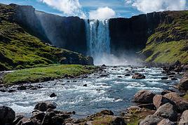
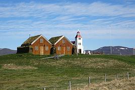
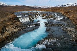
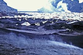
Un trek très sauvage : aucun doute là-dessus. En l'effectuant du 30 août au 7 septembre 2016, nous étions hors-saison : maisons d'été inoccupées et pas de bateau pour les trekkeurs dans leurs Hornstrandir. Nous n'avons rencontré absolument aucun autre être humain pendant ces neuf jours de marche ! Peut-être pas les plus beaux paysages du monde, mais une sensation de proximité à la nature impressionnante. Que ce soit les renards polaires ou les phoques, ils viendront à votre rencontre, nullement effrayés. Aucun hébergement; tout ce fait en camping sauvage. Un peu plus fréquenté, le Hornstrandir est desservi en juillet-août par des bateaux. Notre itinéraire ne reste qu'un seul jour dans cette zone. Les trois premiers jours sont les plus isolés : aucun chemin et pas de réseau téléphonique. La redescente en 5 jours de la côte du Strandir est moins difficile, malgré d’impressionnant gués à traverser : la plupart du temps vous marcherez sur un chemin et vous croiserez quelques maisons d'été. Par contre, en effectuant ce trek fin août/début septembre, elles seront toutes inhabitée et le chemin sera désert. Bref, c'est un trek difficile et il faut de l'expérience en randonnée pour s'y lancer. On le répète les difficultés sont nombreuses : orientation hors sentier, passage un peu technique/raide, savoir tracer son chemin à vu, traverser des marrais innondés et marché toute la journée avec les pieds trempés, n'avoir "aucune sortie de secours", très peu de réseau téléphonique, un potentiel de mauvais temps élevé et gués gelés difficiles à passer (rien à voir avec les gués facile du Laugavegur, aucun ravitaillement évidement (mais de l'eau pure partout par contre),
Carte : C'est => celle çi au 100'000ème <=
Trace GPS : => Télécharger sur Wikiloc <=
Quand y aller ?
Juillet-Août si vous souhaitez bénéficier des bateaux. Septembre si vous voulez faire le même trek que nous et ne voir personne. J'imagine que juin est trop tôt : cols encore enneigés et gués infranchissable avec la fonte des neiges.
Comment y aller ?
En stop, il n'y a pas de bus ! Pour faire plus court, l'été il y a un service de bateau pour différent points dans le Hornstrandir depuis Isafjordur mais très onéreux (70 à 80€ la place et par trajet). En stop, facile sur la 61 entre Holmavik et Isafjördur. ça se complique ensuite, 39km sur une piste de terre qui ne dessert que quelques maisons. A 30km, le point de départ d'une balade que certains touristes font pour s'approcher du glacier est un objectif raisonnable : il y a un peu de passage (pour donner un ordre de grandeur, je dirais un véhicule par heure). Par contre, les 9 derniers relève de l'exploit. Vous pourrez les faire sur la route à pied ou en coupant dans la montagne, le long du glacier. A l'autre bout du trek, il y a trois fermes quelques kilomètres avant la fin de la route, juste avant un gué... l'été, vous pourrez éventuellement comptez sur le stop en s'armant de patience. Dès fin août, cela relève du miracle... prévoyez un jour de plus, comme nous l'avons fait, pour marcher 20km jusqu'à rejoindre la route entre Holmavik et Nordurfjordür. Nous n'avons vu aucune voiture sur ce trajet et aucune maison habitée. Ensuite, un peu plus de passage sur cette côte, mais les voitures restent rares.
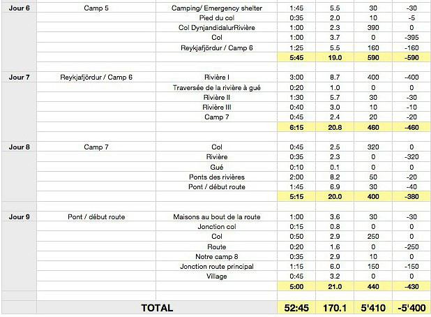
Récapitulatif de nos étapes :
Description de nos étapes :
Jour 1 : Si possible, aller au bout de la route. Du pont, prendre la piste de terre à droite. Après 100 à 200 mètres, monter à peu près tout droit dans les hautes herbes. Pénible. On retrouve les cairns plus haut mais il n'y a pas de chemin clair. Au début, se repérer aux poteaux d'une ancienne ligne téléphonique. Suivre les cairns de grandes tailles mais très espacés. Cela peut être problématique par faible visibilité. Grand plateau très exposé au vent. Univers rocailleux et neivés persistants toute l'année. De l'autre côté, courte descende raide mais ça passe bien partout. Assez marécageux ensuite. A la fin, couper en tirant sur la droite jusqu'à retrouver un bon chemin juste au-dessus du niveau de la mer. Une petite avancée de terre dans le fjord permet de camper au bord de l'eau. Petite rivière venant de la droite mais eaux très terreuse. Mieux vaut aller en chercher ailleurs, il y a d'autres cours d'eau à proximité. Suivant le niveau de la marrée, cette bande de terre se situe à peu près où se jettent le delta de la rivière dans la mer. Pensez à ne pas vous mettre trop près de l'eau si la marée monte ou si des vagues déferlent (mais ça a l'air asez calme dans ce fjord).
Jour 2 à 9 : Sur mon blog
Pour des topos de treks et des informations précises sur les pays que j'ai visités, rendez-vous sur mon blog : https://treketvoyages.com/.
Il fonctionne comme un modeste guide de voyage et non comme un récit de voyage.
Quelques photos : => Plus de photo sur mon blog <=
Pour des topos de treks et des informations précises sur les pays que j'ai visités, rendez-vous sur mon blog : https://treketvoyages.com/.
Il fonctionne comme un modeste guide de voyage et non comme un récit de voyage.
Salut Julien!
MERCI+++ pour ce topo sur le Hornstrandir!
Quelle riche idée d'être allé là-bas en vous affranchissant des bateaux et de la foule estivale!
Du coup vous avez eu les renards pour vous tous seuls et je ne peux pas m'empêcher de penser qu'ils devaient manquer de compagnie vu le nombre de rencontres que vous semblez avoir faites!
Dans quels coins les avez-vous vu? J'imagine surtout vers Hornvik?
J'adore la photo du renard sur la plage, en particulier!
N'avez-vous pas été tentés de fermer la boucle en traversant le Dyngjökull, ça semble faisable pour de bons marcheurs comme vous?
Sinon quels sont tes prochains plans?
A+
Marie
Merci pour vos messages !
Oui, c'était magnifique ces renards polaires... ils approchaient à moins de 50 centimètres de nous. Ceux en photo c'était à Hornvik effectivement. Les autres sur la plage de Bolungarvik sur la côte du Strandir. Quelques autres aussi au bout, à 30km environ du terme, mais plus farouche.
Nous avions pensé à cette traversée du glacier mais le temps nous en a empêché. Déjà, nous n'avons eu qu'une demi-journée de ciel bleu et le reste gris. Très peu de pluie heureusement. Par contre, arrivé à Reykjavfjordur, là dès l'après-midi c'était du brouillard qui nous empêchait de voir à plus de 50m, donc impossible. Mais effectivement, on y avait songé !
Pour la suite, je pars 10 jours au Maroc le mois prochain puis de fin décembre à fin février en Patagonie. Et je retourne en avril en Islande pour du ski de rando !
A bientôt,
Julien
Pour des topos de treks et des informations précises sur les pays que j'ai visités, rendez-vous sur mon blog : https://treketvoyages.com/.
Il fonctionne comme un modeste guide de voyage et non comme un récit de voyage.
Chers Voyageurs, Je sais qu’il y a déjà eu beaucoup de post à ce sujet mais je ne trouve pas réponse à toutes mes questions... J’envisage donc de partir en…
Je prévois un trek de deux mois dès mai 2017. Je serais seule, à pieds avec mon sac, ma tente et mon duvet. Nous pourrions échanger nos infos, questionnements,…
Départ pour jeudi! N étant pas certaine de pouvoir effectuer un trek ds le Land ma... je m oriente vers des rando en étoile... Qu'elle compagnie faut il…
Je souhaite partir en Islande au mois de juin du 14 au 28 Je voulais savoir si le landmannalaugar est ouvert à cette période Quel adresse je peux joindre pour…
Suite a vos nombreux conseils que vous m’avez donner au précédent topic j'ai préparer mon trek de la facon suivante. Je compte sur vous pour me donner vos avis…
Bonjour,
Nous souhaitons faire le trek de 4 jours reliant Mestia à Ushguli sans agence. Il est précisé dans les descriptifs qu'il existe des hébergement à chaque étape, mais on ne trouve pas d'info sur ces hébergements. Quelqu'un a-t-il des infos et un avis sur ce parcours?
We're planning to trek in Peru and Bolivia and would love to find some local agencies.
If you know any, could you share details on prices and, of course, the names of the agencies?
Which trek would you recommend?
Elocine
Je pars en autonomie totale sur un trek au Maroc (10jrs) Imilchil - Aghbalou.
Trouve t-on des cartouches gaz à vis (Coleman, Primus) à Marrakech (adresse) ou villages entre Imilchil - Aghbalou ?
Si non , trouve-t-on des cartouches Butagaz pour camping-gaz (petit volume 230 gr ...)
Merci d' avance pour vos réponses
Hello, I’d like to embark on a little trip in my home country, Switzerland. I’ll start walking from La Cure, heading toward Le Noirmont first, then I’ll improvise my route—but it’ll probably follow the French border... at least as far as Lac de Joux.
I’ll decide day by day how much farther to go after that. My goal is to stay in nature as much as possible, wander around for as long as I can, and restock food in villages or towns along the way.
I’m thinking of mostly camping, but we’ll see if I end up in a hotel or another campsite depending on my route.
I’d love to reach La Chaux-de-Fonds on foot... maybe even Delémont.
The whole thing should take about a week, give or take.
I’ll be bringing my dog, and I’m preparing for this as soon as I’m ready.
Any tips to make sure everything goes smoothly for us? Things I should know—or avoid? What about shepherds with their flocks of sheep? And isn’t hunting season open right now?
I’m not sure if what I’m planning is even doable, which is why I’m asking around.
This’ll be my first time doing something like this—wandering in nature *and* with a dog. I’m really excited for this adventure... and I need it. Thanks!
We’re really keen on ecosystems and want to hike in "natural" ancient forests—not planted woods or areas heavily degraded by human activity. Travel guides (like Lonely Planet) don’t provide much info on this. Could you point us to the most interesting spots?
Thanks in advance for your tips.
We wish you happy holidays and a fantastic 2026, full of discoveries!
Claire and Albert
Hi, this might not be the right section, but I’d like to know if it’s possible to start mountaineering with another person without necessarily hiring a guide. We’ve done quite a bit of hiking but not mountaineering—we’ll just do a half-day glacier course. After that, we were thinking of starting with La Grande Motte and the Pointe de la Traversière, which were recommended to us. Honestly, for things like roping up and knots, I’ll learn at home with lots of videos and a book.
Hi,
I don’t know Switzerland at all and was wondering if Vallée des Joux and especially Dent de Vaulion are packed early in the morning or late in the afternoon in July and September?
If so, do you have any quieter spots to recommend in the area, or in Luxembourg (yes, I know it’s not the same country 😉)?
Thanks a lot!
I’m starting this thread—lots of travelers here have done this trek.
When RMS is mentioned, it’s this agency: Ruwenzori Mountaineering Services (with an *s*), because there’s another one online called Ruwenzori Mountaineering Service (no *s*).
Their site:
www.rwenzorimountaineeringservices.com/
From what I gather, it’s the local mountain guide agency certified by the government?
Jaimerais savoir si quelqu'un aurait fait des treks sur le Ruwenzori et combien ça coute en moyenne, les infrastructures, les paysages la sécurité sur les lieux, merci beaucoup. J'attends avec impatience vos réponses.
We’re leaving in 9 days for a two-week trip to Madeira, mainly to hike.
From my research, I’ve found that since last year, access to most trails—and systematically for the most popular ones—is now paid. You have to pay an access fee of 4.50 € per person per classified hike in 2026, and even 10.50 € for the most iconic hike: Pico Arieiro to Pico Ruivo. When paying, you also have to choose a day and a 30-minute time slot for your start time. Of course, this reservation is neither changeable nor refundable, even if the weather that day is terrible.
Personally, given the massive influx of tourists to the island in recent years, I don’t mind paying a fee to help maintain the trails. Similarly, setting a limit on the number of people who can hike them per day is certainly preferable to preserve this priceless heritage.
However, what’s much less fair is that in reality, most of the available spots are reserved: 1/ for Madeira residents (which is normal); 2/ for "economic operators" (meaning local tour operators). For example, if you’re a non-resident (independent tourist), no booking is possible for the Pico Arieiro hike for an early morning start before September! So, unfortunately, we’ll have to skip this hike.
It’s the same issue for Ponta de São Lourenço, the 25 Fontes, Pico Ruivo... in short, all the most popular hikes. Oh well, we’ll skip those too!
So my question is: which hikes do you recommend where we won’t face the huge crowds that the others get? And where we can book the day before for the next day, taking the weather into account?
Finally, a quick accommodation question: we’ve booked the first week in Funchal, but I haven’t decided yet for the second week. Do you have any advice on where to stay in the south or north, preferably avoiding overly concrete-heavy and touristy spots?
I’m reposting about the logistics for Samaria Gorge.
I’d love to get recent info, especially about whether it’s possible to park my car in Omalos, do the hike, and then catch a bus back to my vehicle.
In theory, it’s doable, but when you check the KTEL website, there aren’t any feasible schedules listed. If anyone has recently organized this with reliable, verified details, I’d really appreciate it. Thanks in advance!
Hi there,
We’re flying from Montreal to Lyon this August to go hiking in the French Alps. We’ve rented a car and will be staying at campgrounds. We’re planning to do day hikes and want to stay a few days in one spot, do a few hikes, then move on to our next camping spot. Could you share your favorite spots or any recommendations for places to spend a few days with great hikes?
A few details:
We arrive in early August and leave in early September.
We’re looking for day hikes (or shorter), moderate difficulty, with a cumulative elevation gain of no more than 1000m, and of course, beautiful scenery!
We’d prefer not to drive too much—maybe it’s best not to head too far south and deal with unnecessary heat?
Along the same lines, if you know of any great campgrounds where we can start our hike directly without needing the car, we’d love to hear your suggestions!
Bonjour
Souhaitant faire de la randonnée sur cette île, je voudrais d'abord savoir quelle serait la période la plus favorable sachant que j'avais passé quelques jours en novembre 2018 pas pour cette activité mais plus pour une simple découverte de l'île et le temps n'était pas top notamment en montagne. Donc peut on choisir une organisation en étoile sachant que je louerai un véhicule avec éventuellement 2 points d'hébergement.
Je n'envisage pas d'intégrer une structure mais de partir à 2 et de s'organiser sauf si vous me conseillez une agence locale ou un guide local. Enfin même si je compte me procurer les différents supports, carte et topo guide plus gps je vous remercie de bien vouloir me communiquer les randos à faire en priorité
Merci beaucoup pour vos informations
I’m planning to do the Mercantour crossing following the Randoxygène route in mid-July.
I’m used to hiking in the mountains, but I sometimes get vertigo, for example on ridges with drops on both sides. I wanted to check if there are any T4 or T3-T4 sections and find out if there are any very exposed passages—and if so, where—so I can plan an alternative route.
Can anyone give me some info on this?
Thanks!
I’m planning a trip around Cap Corse and the AGRIATES in 2026, from May 8th to 15th (there are still 2 spots left, by the way! Just DM me if you're interested).
I’d love to know which hikes are worth prioritizing in the AGRIATES. We’ll be staying in SALECCIA for two days as our base—what should we focus on from there?
A round trip to IGNHU beach? Any other suggestions?
For Ostricano, I think it’s too far for a round trip...
Thanks for your tips!
Have a great day,
Anie, Toulouse
I’d like to get some info about the GR10 Pyrenees traverse. I need help planning the daily stages and accommodations—my wife isn’t an experienced hiker but walks a lot, so I’d like to schedule shorter walking days and thus a longer overall trip in terms of number of days.
Could anyone give me some help and advice?
Best regards,
New to this forum, I’m planning a pretty big project for 2028.
I’m heading to Nepal to do a trek from Kathmandu all the way to Everest Base Camp (a cool 5,300 m 😄).
This trek is a bit special because even though I’ll be part of a group, I’m going solo (so far, no problem—I’m used to it). But it’s my first real trek, and it’s also a humanitarian one: once I reach base camp, I’ll stay an extra week to help clean up the waste left by tens of thousands of climbers! Since I’m originally from South America, from two countries that share the Andes, I have a deep respect for mountains—they fascinate me. So Everest… it’s kind of the trip of a lifetime!
So, a little question for those who’ve done treks to Everest before… any tips for good mental preparation (I’m already working on the physical side)?
Hi there, I’m planning the Annapurna Circuit for March 2027 and I’m looking for a local agency with a local guide—preferably French-speaking—to arrange this trek for us. Any suggestions? Thanks
Hello!
We’re spending a few days in Toraja country at the end of May. We’d love to do a day trek—taking our time—on a route that’s stunning in terms of scenery, but not a level 5 in difficulty!
Any suggestions you can share, please?
Thanks in advance
I’d like to do the Mare a Mare Sud in May over 4 days. I’ve found quite a few places to stay along the route, but I’m stuck on the start and finish.
I’ll be arriving by plane on Sunday evening and would like to start pretty early on Monday morning. Ideally, accommodation right at the trailhead (Alzu di Gallina) would be amazing, but I can’t find anything. Any tips?
Also, for the transfer from Figari Airport to Porto Vecchio or Alzu di Gallina?
At the end, I’d like to pick up a rental car—any advice on that too?
I’m traveling solo by plane to Catania in May and plan to hike the northern side of Etna, starting from Linguaglossa where I’ll arrive by bus. After that, I’d love some info on how to get up to Piano Provenzana (shuttles or hitchhiking), since it seems there’s no public transport except in the summer. Can you sleep there in a free or cheap refuge, or camp? And how far up can you go without having to hire a guide? Thanks in advance. Bernard.
Bonjour a tous,
je pars en voyage au Maroc en aout et nous allons commencer par nous arrêter a Chefchaouen(nous sommes en voiture).
Ma question: quelqu'un peut il m'indiquer un itinéraire de rando en boucle d'entre 5 et 7 jours aux départ de Chefchaouen dans le parc de Talassemtane passant si possible par le pont de dieux?Ou un guide papier qui en reunis quelques uns?
Nous privilégions le camping sauvage et les gites.
Merci d'avance
Hi there, for those who’ve been recently—is it possible to find other solo travelers in March on the island to share transport or room costs? It doesn’t seem easy to travel on a budget.
If you have any recommendations for simple lodgings or places with dorms, I’d love to hear them.
For those who’ve done multi-day treks while moving around: do you need to bring your own sleeping bag? I’d love to hear about itineraries you’ve done without a guide, just with a map and GPS.
Thanks, and have a great day!
Hi everyone!
We’re planning a 15-day road trip to Scotland this summer, specifically to explore and hike on Lewis and Harris—places we’ve never been before. We’ve visited other islands on previous road trips in Scotland (we usually go in April for a week). This would be our first time in Scotland in the summer and for 15 days. We’re looking at late August to early September.
I’m currently drafting the itinerary. We’d be crossing from Ullapool and were thinking of spending 3 nights on Harris and 4 nights on Lewis.
Does that sound balanced to you? Is it better to keep the same accommodation on Harris and the same on Lewis to explore the area? I’d love to hear about any past experiences you’ve had on these islands.
Thanks!
Hi there, I’m trying to leave for 15 days very soon to São Vicente. I’m either looking to join an agency or figure things out on my own to go hiking on one of these islands or both. From what I’ve seen, it’s not easy to organize with local transport, so it gets expensive. Can I use the services of a small local agency? I’m looking for the simplest way to hike for several days. Also, how do you get from São Vicente to São Nicolau? Thanks in advance and have a great day!
Aichatou
I’ve been wanting to do this for several years, and this year’s the one. Next September, I’ll be trekking in Tusheti (Georgia), from Omalo to Shatili.
Of course, I won’t be renting a vehicle that’d just sit unused. No problem getting to Pshaveli, but from there to Omalo, it’s a dirt road (still the case?)
There must be some form of public transport since there are so many guesthouses, and not all travelers come in a 4x4.
If any of you have been to Omalo, could you confirm that these shared transports exist and how often they run?
we’re planning a trip to Yellowstone and hoping to do a three-day backcountry hike if we get a permit.
if any of you have done this before, could you let me know if it’s possible to find water along the way? And if we can transport it, are we allowed to use a stove?