Bonsoir , par en novembre pour le trek des annapurnas est envisage de faire le tour des 5 cols nous serions 3 , mais voudrez le faire sans grosse logistique , merci pour vos infos .
Oui le tour des Annapurnas ne compte que un (Thorung La) ou possiblement deux (Ghorepani) cols. Ou peut-etre en effet on peut arriver a 5 si on commence et on finit de marcher a Pokhara meme pour faire un tour complet a pied.
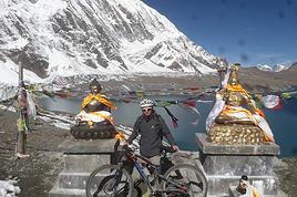
À nagwal on quitte la tracé normal direction naar on passé un premier col à 5305 mt au ensuite le teri bhanjhang 5595 , le baha bhanjhang 4380 mt le byu 4077 mt on arrive à muktinah on remonte pour passer le thorung pass 5416 mt on arrive à manang et on passé le bastern pass .
Pour ce tour je pense qu'il me faut un minimum de logistique ( sherpas porteur , Cook ) mais je ne souhaite pas qu'on se transforment en caravane .
De plus le thorong lha depuis muktinath bonjour la bavante
Ce n'est peut-être pas le plus grand challenge. Car, à partir du lac Tilicho, l'enchaînement du Tilicho Eastern Pass (5365 m) et du Mandala Pass (5330 m) impose un long passage au-dessus de 5000 m avant de redescendre vers Thinigaon / Jomsom.
Fabrice
S'exposer à l'Etranger lointain amène à mieux connaître et comprendre sa propre Culture.
au ensuite le teri bhanjhang 5595, le baha bhanjhang 4380 mt le byu 4077 mt on arrive à muktinah
Vous avez pensé à l'agence pour obtenir les permis? Surtout pour entrer au Mustang par cette voie.A ma connaissance l'entée au Haut Mustang ne se fait que par Kagbeni.( seul check post)
Ce n'est peut-être pas le plus grand challenge. Car, à partir du lac Tilicho, l'enchaînement du Tilicho Eastern Pass (5365 m) et du Mandala Pass (5330 m) impose un long passage au-dessus de 5000 m avant de redescendre vers Thinigaon / Jomsom.
Donc si je comprend bien c pas une bonne idée cet variante ?
Pas tout à fait. Mon commentaire sur la zone étendue au-dessus de 5000 m signifie que ce n'est pas une petite balade de montagne à yak, les mains dans les poches.
Pour ce tour je pense qu'il me faut un minimum de logistique (sherpas porteur, Cook) mais je ne souhaite pas qu'on se transforment en caravane.
1-Ce trek vous fait pénétrer d'abord dans une" restrected area" :Le Nar/phu ( permis restrected area nécessaire) puis dans le haut Mustang où seule une agence agréée et obligatoire est à même de faire la demande de permis auprès des services de l'immigration.A titre individuel c'est impossible. Le prix du permis ( même pour un seul jour) est de 500 dollars/pers . Ce permis n'est délivré que pour 2 personnes au minimum soit 1000 dollars pour 2. S'y ajoutent les frais de guide ( obligatoire) et de nourriture+ logement. D'autre part l'entrée au haut Mustang ne peut se faire que par Kagbeni (seul endroit où il y a un check post) par contre il est possible d'en ressortir par d'autres endroits comme le Teri la vers Muktinath ou Le Saribung la vers Phu.
2- L'ascension du Thorung pass à partir de Muktinath vous fait faire un dénivelé de 1600m entre 3800m et 5400m. Mieux vaut être en bonne condition physique! (à moins de bivouaquer avant le col.)
Le tour classique n'exclut pas de faire des escapades hors de l'autoroute qu'est devenu l'itinéraire historique.
En premier lieu, le passage en altitude à partir de Pisang pour Gyaru et Ngawal
Depuis Ngawal, il est possible d'atteindre le Kang La en aller-et-retour sans devoir souscrire le permis de zone à accès restreint Naar Phu (tant qu'il n'y a pas de poste de contrôle sur le versant sud).
De Ngawal, on peut poursuivre en altitude via Julu / Chulu vers Braka (dont le sentier NATT supérieur croisant le sentier du lac gelé).
Depuis Manang, on peut aussi atteindre le lac Tilicho, via Khangsar, Shree Kharka, et Tilicho Base Camp. Ensuite, sans repasser par Manang, il est possible de rejoindre via Old Khangsar l'itinéraire classique montant vers le Thorung La.
L'escapade du lac Tilicho (4920 m) assure une bonne acclimatation à l'altitude. Lodges à Shree Kharka et Tilicho Base Camp au pic de la saison touristique, à valider à Khangsar.
Tant le Kang La que l'escapade du lac Tilicho semblent offrir de superbes paysages. "Semblent", car je n'ai jamais encore été au Népal. Mes suggestions ne sont que le fruit de ma préparation livresque en vue d'un trek prévu pour mi-novembre 2017.
Fabrice
S'exposer à l'Etranger lointain amène à mieux connaître et comprendre sa propre Culture.
Depuis Ngawal, il est possible d'atteindre le Kang La en aller-et-retour sans devoir souscrire le permis de zone à accès restreint Naar Phu (tant qu'il n'y a pas de poste de contrôle sur le versant sud).
Le permis "Nar Phu" est plus abordable que celui du haut Mustang ( On est loin des 500 dollars!) et de plus si les infos de l'ambassade de France sont correctes ce serait maintenant "ouvert aux treks individuels" donc le permis "serait" délivré comme le TIMS à l'office du tourisme...ça reste à vérifier. J'ai lu quelque part le récit d'un trekker danois qui s'y serait rendu sans guide.
np.ambafrance.org/Le-Trek-au-Nepal
Nar, Phu, et au nord de Tilche (Région de Manang) Septembre à Novembre : 90 USD par semaine par personne.
Decembre à Août : 75 USD par semaine par personne.
Perspectives intéressantes si elles se confirment.
J'ai lu quelque part le récit d'un trekker danois qui s'y serait rendu sans guide.
Si tu remets la "main" sur ce compte-rendu, cela m'intéresserait que tu m'en communiques les références.
Je note aussi que la zone "au-dessus de Tilche" serait aussi couverte. A ce jour, je n'avais pas connaissance de poste de contrôle, hormis à Dharapani. Et je comptais marcher librement à mon rythme, sans contrainte d'un guide, une fois franchi le Larkya La (Tour du Manaslu).
Fabrice
S'exposer à l'Etranger lointain amène à mieux connaître et comprendre sa propre Culture.
Le permis "Nar Phu" est plus abordable que celui du haut Mustang ( On est loin des 500 dollars!) et de plus si les infos de l'ambassade de France sont correctes ce serait maintenant "ouvert aux treks individuels" donc le permis "serait" délivré comme le TIMS à l'office du tourisme...ça reste à vérifier. J'ai lu quelque part le récit d'un trekker danois qui s'y serait rendu sans guide.
np.ambafrance.org/Le-Trek-au-Nepal
Effectivement, le texte de l'Ambassade de France est "ouvert".
Mais le Naar Phu est toujours sur la liste des zones conditionnées à l'obtention d'un permis spécial sur le site web du Ministère de l'Immigration népalais, cf. www.nepalimmigration.gov.np/...ing-routesareas.....
Aucune exception n'est mentionnée sur l'obligation d'être accompagné.
certain trekking regions known as 'Restricted Areas' (...) are highly regulated by the Government of Nepal and hence FITs are strictly forbidden. Trekking in these areas is allowed only upon acquiring permit from the Department of Immigration.
Interested trekkers should contact the authorized trekking agencies who then can apply for permits (on behalf of trekkers) at the Department of Immigration fulfilling all the necessary formalities. Trekkers should be trekking in a group (of minimum two persons) accompanied by licensed trekking guide. Individual trekker cannot apply for the permit.
Copié cette heure même sur le site web du DoI (www.nepalimmigration.gov.np/content/ab.html).
Reste à savoir si le site officiel népalais est à jour. En tout cas, il serait intéressant de lire attentivement le récit du trekkeur danois : est-il officiellement passé en solitaire, sans le moindre passe-droit ?
Fabrice
S'exposer à l'Etranger lointain amène à mieux connaître et comprendre sa propre Culture.
Oui il y a des endroits qui sont sur la liste officielle 'Restricted' mais qui sont en fait permis, comme Thuman et Timure dans le Langtang, ou bien sans controle, tel que la plus grande partie du district de Taplejung et du trek du Kanchenjunga, jusque Ghumsa.
Il n'y a pas de controle entre le col et Dharapani, mais a Dharapani le point de controle est en face du pont avec une vue sur les gens qui traversent le pont (et donc viennent du tour du Manaslu). Mais tu n'auras qu'a dire que ton guide viendra plus tard avec tes compagnons.
Oui il y a des endroits qui sont sur la liste officielle 'Restricted' mais qui sont en fait permis, comme Thuman et Timure dans le Langtang, ou bien sans controle, tel que la plus grande partie du district de Taplejung et du trek du Kanchenjunga, jusque Ghumsa.
Pas simple.
Si j'en ai le temps, je vais peut-être préparer un scénario Naar Phu au cas où je découvre à Katmandou que la zone est en effet ouverte aux trekkeurs étrangers indépendants.
Il n'y a pas de controle entre le col et Dharapani, mais a Dharapani le point de controle est en face du pont avec une vue sur les gens qui traversent le pont (et donc viennent du tour du Manaslu). Mais tu n'auras qu'a dire que ton guide viendra plus tard avec tes compagnons.
Merci Pierre pour cette précision. C'est en effet ce que j'imaginais répondre en cas de contrôle.
Comme je poursuis vers le Thorung La, je peux aussi poursuivre sur 1 km en rive gauche de la Marsyangdi pour franchir un pont plus en amont.
Fabrice
S'exposer à l'Etranger lointain amène à mieux connaître et comprendre sa propre Culture.
Je t'arrete tout de suite quant a l'histoire du trekkeur danois.
J'ai lu son CR (surement un des premiers ecrits sur la vallee de Naar-Phu d'ailleurs) et il n'est pas monte seul "en autonomie" dans la vallee, mais accompagne d'un ami nepalais a lui (pas forcement un guide, d'apres mes souvenirs) et de porteurs.
Il etait "seul" dans le sens "seul etranger", alors que le permis stipule la limite minimale a 2 etrangers + un guide nepalais.
On sait depuis lors qu'il est possible de "virtualiser" le 2nd etranger, par une magouille bien simple realisee par une agence, soit en payant 2 fois le permis et en presentant un passeport d'un etranger lambda qui ne participera meme pas au trek.
Pour Naar-Phu, il y a un checkpost a Koto qui est la porte d'entree de la vallee de Phu. A mon sens, outre l'axe Lo Manthang Phu par les "alpages" (kharka) ou le passage du Kang La qui mene a Naar, pas d'autres voies accessibles facilement.
(de memoire, aucun controle a Phu ou Naar, ni a Ngawal)
il n'est pas monte seul "en autonomie" dans la vallee, mais accompagne d'un ami nepalais a lui (pas forcement un guide, d'apres mes souvenirs) et de porteurs.
Merci Pierre-Yves pour cet éclairage.
On n'a pas tous la même compréhension du terme "alone". 😎
Quand on me demande si je suis accompagné, j'évoque mon sac-à-dos 🙂.
Fabrice
S'exposer à l'Etranger lointain amène à mieux connaître et comprendre sa propre Culture.
Tour des Annapurnas mi octobre-novembre 2019 et pas mars comme prévu initialement Grand merci à Djalma et aussi à d’autres personnes intervenues dans la…
Nous revenons d'un trek au Népal et avons rencontré un guide népalais exceptionnel que nous souhaitons faire partager. Remesh et son équipe est très ouvert aux…
Nous aimerions faire un trek au Népal, on pensait au tour de l’Annapurna, moins cher que le trek de l'Everest. Notre idée est de le faire sans guide et sans…
Je prépare le Tour des Annapurnas pour Mars 2027, je recherche une agence locale avec un guide local, si possible francophone pour nous proposer ce trek.…
J'envisage de repartir au Nepal en 2020 pour un second trek (khopra trek fait cette annee). Je pensais m'orienter vers le classique demi tour des Annapurnas…
Hi,
We’re planning to do the 4-day trek from Mestia to Ushguli without an agency. The descriptions mention that there are accommodations at each stop, but we can’t find any details about them. Has anyone got info or feedback on this route?
We're planning to trek in Peru and Bolivia and would love to find some local agencies.
If you know any, could you share details on prices and, of course, the names of the agencies?
Which trek would you recommend?
Elocine
Je pars en autonomie totale sur un trek au Maroc (10jrs) Imilchil - Aghbalou.
Trouve t-on des cartouches gaz à vis (Coleman, Primus) à Marrakech (adresse) ou villages entre Imilchil - Aghbalou ?
Si non , trouve-t-on des cartouches Butagaz pour camping-gaz (petit volume 230 gr ...)
Merci d' avance pour vos réponses
Hello, I’d like to embark on a little trip in my home country, Switzerland. I’ll start walking from La Cure, heading toward Le Noirmont first, then I’ll improvise my route—but it’ll probably follow the French border... at least as far as Lac de Joux.
I’ll decide day by day how much farther to go after that. My goal is to stay in nature as much as possible, wander around for as long as I can, and restock food in villages or towns along the way.
I’m thinking of mostly camping, but we’ll see if I end up in a hotel or another campsite depending on my route.
I’d love to reach La Chaux-de-Fonds on foot... maybe even Delémont.
The whole thing should take about a week, give or take.
I’ll be bringing my dog, and I’m preparing for this as soon as I’m ready.
Any tips to make sure everything goes smoothly for us? Things I should know—or avoid? What about shepherds with their flocks of sheep? And isn’t hunting season open right now?
I’m not sure if what I’m planning is even doable, which is why I’m asking around.
This’ll be my first time doing something like this—wandering in nature *and* with a dog. I’m really excited for this adventure... and I need it. Thanks!
We’re really keen on ecosystems and want to hike in "natural" ancient forests—not planted woods or areas heavily degraded by human activity. Travel guides (like Lonely Planet) don’t provide much info on this. Could you point us to the most interesting spots?
Thanks in advance for your tips.
We wish you happy holidays and a fantastic 2026, full of discoveries!
Claire and Albert
Hi, this might not be the right section, but I’d like to know if it’s possible to start mountaineering with another person without necessarily hiring a guide. We’ve done quite a bit of hiking but not mountaineering—we’ll just do a half-day glacier course. After that, we were thinking of starting with La Grande Motte and the Pointe de la Traversière, which were recommended to us. Honestly, for things like roping up and knots, I’ll learn at home with lots of videos and a book.
Hi,
I don’t know Switzerland at all and was wondering if Vallée des Joux and especially Dent de Vaulion are packed early in the morning or late in the afternoon in July and September?
If so, do you have any quieter spots to recommend in the area, or in Luxembourg (yes, I know it’s not the same country 😉)?
Thanks a lot!
Jaimerais savoir si quelqu'un aurait fait des treks sur le Ruwenzori et combien ça coute en moyenne, les infrastructures, les paysages la sécurité sur les lieux, merci beaucoup. J'attends avec impatience vos réponses.
We’re leaving in 9 days for a two-week trip to Madeira, mainly to hike.
From my research, I’ve found that since last year, access to most trails—and systematically for the most popular ones—is now paid. You have to pay an access fee of 4.50 € per person per classified hike in 2026, and even 10.50 € for the most iconic hike: Pico Arieiro to Pico Ruivo. When paying, you also have to choose a day and a 30-minute time slot for your start time. Of course, this reservation is neither changeable nor refundable, even if the weather that day is terrible.
Personally, given the massive influx of tourists to the island in recent years, I don’t mind paying a fee to help maintain the trails. Similarly, setting a limit on the number of people who can hike them per day is certainly preferable to preserve this priceless heritage.
However, what’s much less fair is that in reality, most of the available spots are reserved: 1/ for Madeira residents (which is normal); 2/ for "economic operators" (meaning local tour operators). For example, if you’re a non-resident (independent tourist), no booking is possible for the Pico Arieiro hike for an early morning start before September! So, unfortunately, we’ll have to skip this hike.
It’s the same issue for Ponta de São Lourenço, the 25 Fontes, Pico Ruivo... in short, all the most popular hikes. Oh well, we’ll skip those too!
So my question is: which hikes do you recommend where we won’t face the huge crowds that the others get? And where we can book the day before for the next day, taking the weather into account?
Finally, a quick accommodation question: we’ve booked the first week in Funchal, but I haven’t decided yet for the second week. Do you have any advice on where to stay in the south or north, preferably avoiding overly concrete-heavy and touristy spots?
I’m reposting about the logistics for Samaria Gorge.
I’d love to get recent info, especially about whether it’s possible to park my car in Omalos, do the hike, and then catch a bus back to my vehicle.
In theory, it’s doable, but when you check the KTEL website, there aren’t any feasible schedules listed. If anyone has recently organized this with reliable, verified details, I’d really appreciate it. Thanks in advance!
Hi there,
We’re flying from Montreal to Lyon this August to go hiking in the French Alps. We’ve rented a car and will be staying at campgrounds. We’re planning to do day hikes and want to stay a few days in one spot, do a few hikes, then move on to our next camping spot. Could you share your favorite spots or any recommendations for places to spend a few days with great hikes?
A few details:
We arrive in early August and leave in early September.
We’re looking for day hikes (or shorter), moderate difficulty, with a cumulative elevation gain of no more than 1000m, and of course, beautiful scenery!
We’d prefer not to drive too much—maybe it’s best not to head too far south and deal with unnecessary heat?
Along the same lines, if you know of any great campgrounds where we can start our hike directly without needing the car, we’d love to hear your suggestions!
Bonjour
Souhaitant faire de la randonnée sur cette île, je voudrais d'abord savoir quelle serait la période la plus favorable sachant que j'avais passé quelques jours en novembre 2018 pas pour cette activité mais plus pour une simple découverte de l'île et le temps n'était pas top notamment en montagne. Donc peut on choisir une organisation en étoile sachant que je louerai un véhicule avec éventuellement 2 points d'hébergement.
Je n'envisage pas d'intégrer une structure mais de partir à 2 et de s'organiser sauf si vous me conseillez une agence locale ou un guide local. Enfin même si je compte me procurer les différents supports, carte et topo guide plus gps je vous remercie de bien vouloir me communiquer les randos à faire en priorité
Merci beaucoup pour vos informations
I’m planning to do the Mercantour crossing following the Randoxygène route in mid-July.
I’m used to hiking in the mountains, but I sometimes get vertigo, for example on ridges with drops on both sides. I wanted to check if there are any T4 or T3-T4 sections and find out if there are any very exposed passages—and if so, where—so I can plan an alternative route.
Can anyone give me some info on this?
Thanks!
I’m planning a trip around Cap Corse and the AGRIATES in 2026, from May 8th to 15th (there are still 2 spots left, by the way! Just DM me if you're interested).
I’d love to know which hikes are worth prioritizing in the AGRIATES. We’ll be staying in SALECCIA for two days as our base—what should we focus on from there?
A round trip to IGNHU beach? Any other suggestions?
For Ostricano, I think it’s too far for a round trip...
Thanks for your tips!
Have a great day,
Anie, Toulouse
I’d like to get some info about the GR10 Pyrenees traverse. I need help planning the daily stages and accommodations—my wife isn’t an experienced hiker but walks a lot, so I’d like to schedule shorter walking days and thus a longer overall trip in terms of number of days.
Could anyone give me some help and advice?
Best regards,
New to this forum, I’m planning a pretty big project for 2028.
I’m heading to Nepal to do a trek from Kathmandu all the way to Everest Base Camp (a cool 5,300 m 😄).
This trek is a bit special because even though I’ll be part of a group, I’m going solo (so far, no problem—I’m used to it). But it’s my first real trek, and it’s also a humanitarian one: once I reach base camp, I’ll stay an extra week to help clean up the waste left by tens of thousands of climbers! Since I’m originally from South America, from two countries that share the Andes, I have a deep respect for mountains—they fascinate me. So Everest… it’s kind of the trip of a lifetime!
So, a little question for those who’ve done treks to Everest before… any tips for good mental preparation (I’m already working on the physical side)?
Hi there, I’m planning the Annapurna Circuit for March 2027 and I’m looking for a local agency with a local guide—preferably French-speaking—to arrange this trek for us. Any suggestions? Thanks
Hello!
We’re spending a few days in Toraja country at the end of May. We’d love to do a day trek—taking our time—on a route that’s stunning in terms of scenery, but not a level 5 in difficulty!
Any suggestions you can share, please?
Thanks in advance
I’d like to do the Mare a Mare Sud in May over 4 days. I’ve found quite a few places to stay along the route, but I’m stuck on the start and finish.
I’ll be arriving by plane on Sunday evening and would like to start pretty early on Monday morning. Ideally, accommodation right at the trailhead (Alzu di Gallina) would be amazing, but I can’t find anything. Any tips?
Also, for the transfer from Figari Airport to Porto Vecchio or Alzu di Gallina?
At the end, I’d like to pick up a rental car—any advice on that too?
I’m traveling solo by plane to Catania in May and plan to hike the northern side of Etna, starting from Linguaglossa where I’ll arrive by bus. After that, I’d love some info on how to get up to Piano Provenzana (shuttles or hitchhiking), since it seems there’s no public transport except in the summer. Can you sleep there in a free or cheap refuge, or camp? And how far up can you go without having to hire a guide? Thanks in advance. Bernard.
Bonjour a tous,
je pars en voyage au Maroc en aout et nous allons commencer par nous arrêter a Chefchaouen(nous sommes en voiture).
Ma question: quelqu'un peut il m'indiquer un itinéraire de rando en boucle d'entre 5 et 7 jours aux départ de Chefchaouen dans le parc de Talassemtane passant si possible par le pont de dieux?Ou un guide papier qui en reunis quelques uns?
Nous privilégions le camping sauvage et les gites.
Merci d'avance
Hi there, for those who’ve been recently—is it possible to find other solo travelers in March on the island to share transport or room costs? It doesn’t seem easy to travel on a budget.
If you have any recommendations for simple lodgings or places with dorms, I’d love to hear them.
For those who’ve done multi-day treks while moving around: do you need to bring your own sleeping bag? I’d love to hear about itineraries you’ve done without a guide, just with a map and GPS.
Thanks, and have a great day!
Hi everyone!
We’re planning a 15-day road trip to Scotland this summer, specifically to explore and hike on Lewis and Harris—places we’ve never been before. We’ve visited other islands on previous road trips in Scotland (we usually go in April for a week). This would be our first time in Scotland in the summer and for 15 days. We’re looking at late August to early September.
I’m currently drafting the itinerary. We’d be crossing from Ullapool and were thinking of spending 3 nights on Harris and 4 nights on Lewis.
Does that sound balanced to you? Is it better to keep the same accommodation on Harris and the same on Lewis to explore the area? I’d love to hear about any past experiences you’ve had on these islands.
Thanks!
Hi there, I’m trying to leave for 15 days very soon to São Vicente. I’m either looking to join an agency or figure things out on my own to go hiking on one of these islands or both. From what I’ve seen, it’s not easy to organize with local transport, so it gets expensive. Can I use the services of a small local agency? I’m looking for the simplest way to hike for several days. Also, how do you get from São Vicente to São Nicolau? Thanks in advance and have a great day!
Aichatou
I’ve been wanting to do this for several years, and this year’s the one. Next September, I’ll be trekking in Tusheti (Georgia), from Omalo to Shatili.
Of course, I won’t be renting a vehicle that’d just sit unused. No problem getting to Pshaveli, but from there to Omalo, it’s a dirt road (still the case?)
There must be some form of public transport since there are so many guesthouses, and not all travelers come in a 4x4.
If any of you have been to Omalo, could you confirm that these shared transports exist and how often they run?
we’re planning a trip to Yellowstone and hoping to do a three-day backcountry hike if we get a permit.
if any of you have done this before, could you let me know if it’s possible to find water along the way? And if we can transport it, are we allowed to use a stove?
Hello,
I’ll be in Nepal from March 6th to 29th (we’re flying into Kathmandu via Varanasi and leaving via Delhi).
I’m a bit confused about the regulations requiring a guide.
My wife and I (we’re 63 and 64) aren’t experienced trekkers—we’re more used to walking on terrain with very moderate elevation changes. I’m looking for fairly easy hikes, possibly day trips.
Here are my questions:
- Does the Poon Hill trek from Pokhara require a guide, or is it better to go through a local agency? (I’ve seen a lot of them offering 4-day packages)
- I’d like to do a few multi-day hikes around Jomsom (Kagbeni, Mukitinath, Lupra, Marpha)... Do you need a guide for those, and can you find accommodations easily without booking in advance?
Last question—I’m really hesitant to lug around a sleeping bag or down jacket during our 6 weeks in India. Can you easily find these kinds of items at reasonable prices in Pokhara?
Thanks in advance for any tips you can share!
Yann