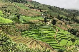
Nous partons la semaine prochaine faire un trek du coté de Sapa. Nous, c'est 4 jeunes.
Comme on arrive le mardi, nous avons pensez aller vite fait voir le marché de Coc Ly, puis revenir le midi sur Sapa et partir en trek l'après-midi et le lendemain, avant de repartir sur Hanoi. Nous ne souhaitons nous passer de tour opérateur et de guide. J'ai trouvé une très belle carte rando pour faire ca tout seul. Cependant, quelques questions :
- est-il facile d'aller de Lao Cai à Coc Ly en arrivant ? Pour quel prix ?
- est-il possible de dormir dans des petits villages non touristiques en arrivant à l'improviste en fin d'après midi ?
- est ce que les gens parlent un peu vietnamien dans ces villages non touristiques ?
:)
Merci pour votre conseil, mais je reste confiant ! Je suis très à l'aise en topographie (j'ai donné des cours) et je pars avec une boussole au cas où le soleil ne serait pas au rendez-vous !
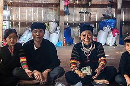
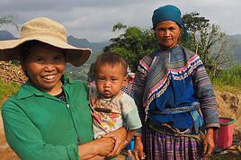
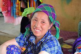
Je n'ai pas essayé mais je pense qu'il y a une chance de pouvoir dormir dans des villages à l'improviste. Mais les villageois ne parlent presque pas (voir pas du tout) vietnamien. J'ai fait un trek autour de Sapa et deux villages à moins de 5 km l'un de l'autre parlent des dialectes différents. Pensez à prendre un imagier.
Nous partons la semaine prochaine faire un trek du coté de Sapa. Nous, c'est 4 jeunes.
Comme on arrive le mardi, nous avons pensez aller vite fait voir le marché de Coc Ly, puis revenir le midi sur Sapa et partir en trek l'après-midi et le lendemain, avant de repartir sur Hanoi. Nous ne souhaitons nous passer de tour opérateur et de guide. J'ai trouvé une très belle carte rando pour faire ca tout seul. Cependant, quelques questions :
- est-il facile d'aller de Lao Cai à Coc Ly en arrivant ? Pour quel prix ?
A mon avis, il vous faudra louer un taxi (à 4 c'est rentabilisé) et probablement un taxi assez grand si vous avez beaucoup de bagages à 4 pour faire l'aller-retour Lao Cai-Coc Ly en une matinée. AU retour vous pouvez demander le taxi de vous déposer à la gare routière ou au point de départ du bus public (jaune et rouge) pour Sapa.
C'est donc le tarif au compte-mètre (ou un forfait à négocier) que vous allez payer. Au compte-mètre, il y a un tarif réduit à partir du 30e ou 40e kilomètre (cela dépend des compagnies). Pour certaines compagnies, si on fait un AR, le retour est souvent à tarif très réduit, par exemple réduction de 80% sur le trajet du retour (qui doit être le même que celui de l'aller). Je ne connais pas le tarif des taxis à Lao Cai. Mais si vous avez un prix moyen de, par exemple 10.000 VND par kilomètre, cela fait environ 70 km jusqu'au marché de Coc Ly soit 700.000 VND pour le trajet aller. En général sur un trajet AR, il y a une heure d'attente gratuite, sinon chaque heure supplémentaire est facturée de 20.000 à 30.000 VN dongs.
- est-il possible de dormir dans des petits villages non touristiques en arrivant à l'improviste en fin d'après midi ?
- est ce que les gens parlent un peu vietnamien dans ces villages non touristiques ?
Merci !
Si vous êtes au milieu de nulle part, qu'il fait nuit, où que l'orage gronde et s'il n'y a pas un hôtel à proximité, vous serez probablement accueilli par les villageois qui comprendront la situation. sauf s'il y a des réglementations en vigueur contre l'accueil d'étrangers.
En principe, toute personne non résidente sur place (vietnamienne ou étrangère) doit être déclarée à la police ou à l'autorité locale (une chose normalement faite par le "sponsor", hôtel, maison d'hôte, homestay officiel, qui vous accueille) quand elle passe la nuit hors de son lieu habituel de résidence.
Pour la langue vietnamienne, à part les coins très reculés et là où on vit en autarcie complète, les membres des ethnies parlent plus ou moins le vietnamien.
Merci pour ces précieuses et précises informations !!
Il n'y a pas de bus ou de minibus entre Lao cai et Coc ly ? Sachant que c'est jour de marché, je pense qu'on ne sera pas les seuls en route !
Merci pour ces précieuses et précises informations !!
Il n'y a pas de bus ou de minibus entre Lao cai et Coc ly ? Sachant que c'est jour de marché, je pense qu'on ne sera pas les seuls en route !
Vous avez un bus qui fait la liaison entre Lao Cai et Bac Ha/Si Ma Cai. Vous pouvez demander à descendre au départ de la TL154 vers Coc Ly, mais il faudra alors vous débrouiller à pied, ou avec des moto-taxi ou avec des taxis du coin s'il y en a...
Une autre possibilité est de continuer en direction de Bac Ha (sur la TL 153) et de descendre au premier bourg (village de Bao Nhai, à 5 km de la QL70). De là il y a des liaisons par bateau (pour touristes) vers le marché de Coc Ly mais je ne sais pas si ces liaisons fonctionnent tout le temps.
Ceci dit, si votre but est de pouvoir être vers midi à Sapa le même jour, vous n'avez pas beaucoup de choix : il vous faut un moyen de transport rapide (le temps c'est de l'argent).
Coucou me revoilà sur le forum après un mois de moto dans le sud du Laos. Pas facile d'aller de Lao Cai à Coc Ly car c'est la route de Bac Ha + une petite route ; c'est donc la voiture mais il est possible qu'il y ait des minibus d'excursion Coc Ly ce jour-là ; il y a plein d'agences sur la place de la gare donc vérifier en arrivant
On ne couche pas où on veut dans les montagnes car c'est controlé par la police et seuls les locaux ayant un permis pour recevoir des étrangers chez eux peuvent le faire. Quant à se balader tout seul, c'est un dédale de pistes une fois sorti des principales, donc on se perd ; si vs ne voulez pas passer par une agence, vous trouverez assez facilement autour de l'église et dans la rue principale de Sapa (Cau Mai) une petite hmong qui vous emmènera chez elle (en anglais et certaines en français, tout appris avec des touristes dans la rue; je suis meme tombé une fois sur une qui parlait súédois !) ; il y en a une maline qui, au lieu de vendre des produits artisanaux, montre son "Livre d'or" aux passants ; authenticité garantie mais je ne vous garantis pas le confort !
Les montagnards sont bien obligés de parler viet meme si ça ne leur plait pas plus que ça !
Méfiez-vous de la vie, car les ratés ne vous rateront pas!
Moi, j'ai acheté le "g'palémo" ; très bien fait mais j'avoue que je ne m'en suis pas beaucoup servi pour l'instant que ce soit au Vietnam ou au Myanmar... mais cela peut toujours être très utile de l'avoir sous la main... ou dans la poche... 😉.
effectivement le lien ne fonctionne pas , mais pas de pb quand on sait que c'a existe😉 c'est 5 euros et je l'ai acheté c'a a l'air pas mal mais a voir à l'usage........
en tout cas c'a m'evitera de me constituer moi même mon imagier, car je galérais
merci donc pour l'info
"c'est pas moi qui fais le voyage, c'est le voyage qui me fait "
b lavilliers
Moi, j'ai acheté le "g'palémo" ; très bien fait mais j'avoue que je ne m'en suis pas beaucoup servi pour l'instant
Exactement pareil.
Nous sommes partis 6 mois en Asie et nous pensions que nous en aurions besoin.
Pas une seule fois nous ne l'avons sorti ... nous avons toujours réussi à nous faire comprendre sans.
Mais c'est vrai que c'est rassurant de l'avoir avec soi.
Cette discussion m'amuse beaucoup ! Ah el monde moderne et ces gadgets électroniques ! Ca fait plus de 40 ans que je sillonne le vaste monde, y compris l'Afrique, sans GPS ni je ne sais quelle autre invention moderne, et je ne me suis jamais perdu ; tout ça, c'est comme le Ipod ; on pense maintenant que c'est absolument indispensable alors que .... A Sapa, on trouve une excellente carte des pistes; du papier, c'est pas mal non plus !
Méfiez-vous de la vie, car les ratés ne vous rateront pas!
"Cette discussion m'amuse beaucoup ! Ah el monde moderne et ces gadgets électroniques !"
Il n'y a rien de moderne ni surtout d'électronique, ni GPS !!! c'est simplement un petit carnet à spirales (en papier cartonné) qui représente 200 dessins pour se faire comprendre... dans toutes les langues...
Si cela peut "rassurer" les personnes qui ne parlent pas la langue du Pays, qui n'ont pas fait le tour du monde et qui désirent voyager par leurs propres moyens sans passer par un voyage en groupe... eh bien... je ne vois pas ce qu'il y a d'amusant... et c'est tout à leur honneur...
Il m'est très souvent arrivé de gribouiller un dessin pour me faire comprendre et ça marche à tous les coups et pourtant je ne suis pas une experte en dessin !!! et en plus avec de grands fous rires !!! donc avoir ce petit carnet en poche, ce n'est pas mal non plus.
A chacun sa façon de voyager pour son plus grand plaisir...
Jacques devait faire référence au conseil suivant: Sinon google image, ça fonctionne aussi.
Qui implique un matériel électronique au fin fond des montagnes, je confesse partager son avis sur ce point😄
Pour bien aimer un pays il faut le manger, le boire et l’entendre chanter. (Michel Déon)
Pas tout à fait, je pensais que le g'machin en était un autre. Google Map et cie, c'est bien beau, mais ça ne vous dit pas quand vous etes en voiture ou en moto si c'est une bonne route goudronnée ou une piste pourrie. Quand je ne suis pas sur, je demande à un guide qui traine dans le coin (ou à l'hotel) comment est la route, ça remplace tous les gadgets 😉
Méfiez-vous de la vie, car les ratés ne vous rateront pas!
Cette discussion m'amuse beaucoup ! Ah el monde moderne et ces gadgets électroniques ! Ca fait plus de 40 ans que je sillonne le vaste monde, y compris l'Afrique, sans GPS ni je ne sais quelle autre invention moderne, et je ne me suis jamais perdu ; tout ça, c'est comme le Ipod ; on pense maintenant que c'est absolument indispensable alors que ....
Comme l'a indiqué Asia7, rien à voir avec un GPS ou n'importe quel autre gadget électronique.
C'est du bon vieux papier 😛 :
Je suis bien curieux d'en voir un ! Je précise que je n'ai rien contre l'électronique, qui peut rendre de très grands services, notemment l'Internet, mais quand je vois sans arret meme un jeune couple s'asseoir à une table de restau, chacun sort immédiatement sa tablette et joue avec sans se dire un mot de toute la soirée, je me pose des questions !
Méfiez-vous de la vie, car les ratés ne vous rateront pas!
Je part en Avril au Vietnam et je veut faire un "trekking" d'un jour sur Sapa le 24 d'Avril (je sais que c'est très peu de temps mais j'ai pas le choix). Je…
Nous souhaiterions faire un trek autour de Sapa sur deux ou trois jours sans passez par une agence. Nous sommes deux, bons marcheurs et souhaiterions croiser…
Nous allons au Vietnam au prochaine vacances de février pour 17 jours sur place. Nous irons découvrir Sapa 2 ou 3 jours et comptons évidemment faire quelques…
Est-ce que la différence de température à Sapa est significative (pour un trek) entre le début décembre et la fin décembre pour influencer mon itinéraire Merci…
Voilà, début Octobre je serai dans le nord et je souhaite faire un trek de au moins 4 jours/3nuits. Il y a tellement de possibilité que du coup je n'arrive pas…
Bonjour,
Nous souhaitons faire le trek de 4 jours reliant Mestia à Ushguli sans agence. Il est précisé dans les descriptifs qu'il existe des hébergement à chaque étape, mais on ne trouve pas d'info sur ces hébergements. Quelqu'un a-t-il des infos et un avis sur ce parcours?
We're planning to trek in Peru and Bolivia and would love to find some local agencies.
If you know any, could you share details on prices and, of course, the names of the agencies?
Which trek would you recommend?
Elocine
Je pars en autonomie totale sur un trek au Maroc (10jrs) Imilchil - Aghbalou.
Trouve t-on des cartouches gaz à vis (Coleman, Primus) à Marrakech (adresse) ou villages entre Imilchil - Aghbalou ?
Si non , trouve-t-on des cartouches Butagaz pour camping-gaz (petit volume 230 gr ...)
Merci d' avance pour vos réponses
Hello, I’d like to embark on a little trip in my home country, Switzerland. I’ll start walking from La Cure, heading toward Le Noirmont first, then I’ll improvise my route—but it’ll probably follow the French border... at least as far as Lac de Joux.
I’ll decide day by day how much farther to go after that. My goal is to stay in nature as much as possible, wander around for as long as I can, and restock food in villages or towns along the way.
I’m thinking of mostly camping, but we’ll see if I end up in a hotel or another campsite depending on my route.
I’d love to reach La Chaux-de-Fonds on foot... maybe even Delémont.
The whole thing should take about a week, give or take.
I’ll be bringing my dog, and I’m preparing for this as soon as I’m ready.
Any tips to make sure everything goes smoothly for us? Things I should know—or avoid? What about shepherds with their flocks of sheep? And isn’t hunting season open right now?
I’m not sure if what I’m planning is even doable, which is why I’m asking around.
This’ll be my first time doing something like this—wandering in nature *and* with a dog. I’m really excited for this adventure... and I need it. Thanks!
We’re really keen on ecosystems and want to hike in "natural" ancient forests—not planted woods or areas heavily degraded by human activity. Travel guides (like Lonely Planet) don’t provide much info on this. Could you point us to the most interesting spots?
Thanks in advance for your tips.
We wish you happy holidays and a fantastic 2026, full of discoveries!
Claire and Albert
Hi, this might not be the right section, but I’d like to know if it’s possible to start mountaineering with another person without necessarily hiring a guide. We’ve done quite a bit of hiking but not mountaineering—we’ll just do a half-day glacier course. After that, we were thinking of starting with La Grande Motte and the Pointe de la Traversière, which were recommended to us. Honestly, for things like roping up and knots, I’ll learn at home with lots of videos and a book.
Hi,
I don’t know Switzerland at all and was wondering if Vallée des Joux and especially Dent de Vaulion are packed early in the morning or late in the afternoon in July and September?
If so, do you have any quieter spots to recommend in the area, or in Luxembourg (yes, I know it’s not the same country 😉)?
Thanks a lot!
Jaimerais savoir si quelqu'un aurait fait des treks sur le Ruwenzori et combien ça coute en moyenne, les infrastructures, les paysages la sécurité sur les lieux, merci beaucoup. J'attends avec impatience vos réponses.
We’re leaving in 9 days for a two-week trip to Madeira, mainly to hike.
From my research, I’ve found that since last year, access to most trails—and systematically for the most popular ones—is now paid. You have to pay an access fee of 4.50 € per person per classified hike in 2026, and even 10.50 € for the most iconic hike: Pico Arieiro to Pico Ruivo. When paying, you also have to choose a day and a 30-minute time slot for your start time. Of course, this reservation is neither changeable nor refundable, even if the weather that day is terrible.
Personally, given the massive influx of tourists to the island in recent years, I don’t mind paying a fee to help maintain the trails. Similarly, setting a limit on the number of people who can hike them per day is certainly preferable to preserve this priceless heritage.
However, what’s much less fair is that in reality, most of the available spots are reserved: 1/ for Madeira residents (which is normal); 2/ for "economic operators" (meaning local tour operators). For example, if you’re a non-resident (independent tourist), no booking is possible for the Pico Arieiro hike for an early morning start before September! So, unfortunately, we’ll have to skip this hike.
It’s the same issue for Ponta de São Lourenço, the 25 Fontes, Pico Ruivo... in short, all the most popular hikes. Oh well, we’ll skip those too!
So my question is: which hikes do you recommend where we won’t face the huge crowds that the others get? And where we can book the day before for the next day, taking the weather into account?
Finally, a quick accommodation question: we’ve booked the first week in Funchal, but I haven’t decided yet for the second week. Do you have any advice on where to stay in the south or north, preferably avoiding overly concrete-heavy and touristy spots?
I’m reposting about the logistics for Samaria Gorge.
I’d love to get recent info, especially about whether it’s possible to park my car in Omalos, do the hike, and then catch a bus back to my vehicle.
In theory, it’s doable, but when you check the KTEL website, there aren’t any feasible schedules listed. If anyone has recently organized this with reliable, verified details, I’d really appreciate it. Thanks in advance!
Hi there,
We’re flying from Montreal to Lyon this August to go hiking in the French Alps. We’ve rented a car and will be staying at campgrounds. We’re planning to do day hikes and want to stay a few days in one spot, do a few hikes, then move on to our next camping spot. Could you share your favorite spots or any recommendations for places to spend a few days with great hikes?
A few details:
We arrive in early August and leave in early September.
We’re looking for day hikes (or shorter), moderate difficulty, with a cumulative elevation gain of no more than 1000m, and of course, beautiful scenery!
We’d prefer not to drive too much—maybe it’s best not to head too far south and deal with unnecessary heat?
Along the same lines, if you know of any great campgrounds where we can start our hike directly without needing the car, we’d love to hear your suggestions!
Bonjour
Souhaitant faire de la randonnée sur cette île, je voudrais d'abord savoir quelle serait la période la plus favorable sachant que j'avais passé quelques jours en novembre 2018 pas pour cette activité mais plus pour une simple découverte de l'île et le temps n'était pas top notamment en montagne. Donc peut on choisir une organisation en étoile sachant que je louerai un véhicule avec éventuellement 2 points d'hébergement.
Je n'envisage pas d'intégrer une structure mais de partir à 2 et de s'organiser sauf si vous me conseillez une agence locale ou un guide local. Enfin même si je compte me procurer les différents supports, carte et topo guide plus gps je vous remercie de bien vouloir me communiquer les randos à faire en priorité
Merci beaucoup pour vos informations
I’m planning to do the Mercantour crossing following the Randoxygène route in mid-July.
I’m used to hiking in the mountains, but I sometimes get vertigo, for example on ridges with drops on both sides. I wanted to check if there are any T4 or T3-T4 sections and find out if there are any very exposed passages—and if so, where—so I can plan an alternative route.
Can anyone give me some info on this?
Thanks!
I’m planning a trip around Cap Corse and the AGRIATES in 2026, from May 8th to 15th (there are still 2 spots left, by the way! Just DM me if you're interested).
I’d love to know which hikes are worth prioritizing in the AGRIATES. We’ll be staying in SALECCIA for two days as our base—what should we focus on from there?
A round trip to IGNHU beach? Any other suggestions?
For Ostricano, I think it’s too far for a round trip...
Thanks for your tips!
Have a great day,
Anie, Toulouse
I’d like to get some info about the GR10 Pyrenees traverse. I need help planning the daily stages and accommodations—my wife isn’t an experienced hiker but walks a lot, so I’d like to schedule shorter walking days and thus a longer overall trip in terms of number of days.
Could anyone give me some help and advice?
Best regards,
New to this forum, I’m planning a pretty big project for 2028.
I’m heading to Nepal to do a trek from Kathmandu all the way to Everest Base Camp (a cool 5,300 m 😄).
This trek is a bit special because even though I’ll be part of a group, I’m going solo (so far, no problem—I’m used to it). But it’s my first real trek, and it’s also a humanitarian one: once I reach base camp, I’ll stay an extra week to help clean up the waste left by tens of thousands of climbers! Since I’m originally from South America, from two countries that share the Andes, I have a deep respect for mountains—they fascinate me. So Everest… it’s kind of the trip of a lifetime!
So, a little question for those who’ve done treks to Everest before… any tips for good mental preparation (I’m already working on the physical side)?
Hi there, I’m planning the Annapurna Circuit for March 2027 and I’m looking for a local agency with a local guide—preferably French-speaking—to arrange this trek for us. Any suggestions? Thanks
Hello!
We’re spending a few days in Toraja country at the end of May. We’d love to do a day trek—taking our time—on a route that’s stunning in terms of scenery, but not a level 5 in difficulty!
Any suggestions you can share, please?
Thanks in advance
I’d like to do the Mare a Mare Sud in May over 4 days. I’ve found quite a few places to stay along the route, but I’m stuck on the start and finish.
I’ll be arriving by plane on Sunday evening and would like to start pretty early on Monday morning. Ideally, accommodation right at the trailhead (Alzu di Gallina) would be amazing, but I can’t find anything. Any tips?
Also, for the transfer from Figari Airport to Porto Vecchio or Alzu di Gallina?
At the end, I’d like to pick up a rental car—any advice on that too?
I’m traveling solo by plane to Catania in May and plan to hike the northern side of Etna, starting from Linguaglossa where I’ll arrive by bus. After that, I’d love some info on how to get up to Piano Provenzana (shuttles or hitchhiking), since it seems there’s no public transport except in the summer. Can you sleep there in a free or cheap refuge, or camp? And how far up can you go without having to hire a guide? Thanks in advance. Bernard.
Bonjour a tous,
je pars en voyage au Maroc en aout et nous allons commencer par nous arrêter a Chefchaouen(nous sommes en voiture).
Ma question: quelqu'un peut il m'indiquer un itinéraire de rando en boucle d'entre 5 et 7 jours aux départ de Chefchaouen dans le parc de Talassemtane passant si possible par le pont de dieux?Ou un guide papier qui en reunis quelques uns?
Nous privilégions le camping sauvage et les gites.
Merci d'avance
Hi there, for those who’ve been recently—is it possible to find other solo travelers in March on the island to share transport or room costs? It doesn’t seem easy to travel on a budget.
If you have any recommendations for simple lodgings or places with dorms, I’d love to hear them.
For those who’ve done multi-day treks while moving around: do you need to bring your own sleeping bag? I’d love to hear about itineraries you’ve done without a guide, just with a map and GPS.
Thanks, and have a great day!
Hi everyone!
We’re planning a 15-day road trip to Scotland this summer, specifically to explore and hike on Lewis and Harris—places we’ve never been before. We’ve visited other islands on previous road trips in Scotland (we usually go in April for a week). This would be our first time in Scotland in the summer and for 15 days. We’re looking at late August to early September.
I’m currently drafting the itinerary. We’d be crossing from Ullapool and were thinking of spending 3 nights on Harris and 4 nights on Lewis.
Does that sound balanced to you? Is it better to keep the same accommodation on Harris and the same on Lewis to explore the area? I’d love to hear about any past experiences you’ve had on these islands.
Thanks!
Hi there, I’m trying to leave for 15 days very soon to São Vicente. I’m either looking to join an agency or figure things out on my own to go hiking on one of these islands or both. From what I’ve seen, it’s not easy to organize with local transport, so it gets expensive. Can I use the services of a small local agency? I’m looking for the simplest way to hike for several days. Also, how do you get from São Vicente to São Nicolau? Thanks in advance and have a great day!
Aichatou
I’ve been wanting to do this for several years, and this year’s the one. Next September, I’ll be trekking in Tusheti (Georgia), from Omalo to Shatili.
Of course, I won’t be renting a vehicle that’d just sit unused. No problem getting to Pshaveli, but from there to Omalo, it’s a dirt road (still the case?)
There must be some form of public transport since there are so many guesthouses, and not all travelers come in a 4x4.
If any of you have been to Omalo, could you confirm that these shared transports exist and how often they run?
we’re planning a trip to Yellowstone and hoping to do a three-day backcountry hike if we get a permit.
if any of you have done this before, could you let me know if it’s possible to find water along the way? And if we can transport it, are we allowed to use a stove?
Hello,
I’ll be in Nepal from March 6th to 29th (we’re flying into Kathmandu via Varanasi and leaving via Delhi).
I’m a bit confused about the regulations requiring a guide.
My wife and I (we’re 63 and 64) aren’t experienced trekkers—we’re more used to walking on terrain with very moderate elevation changes. I’m looking for fairly easy hikes, possibly day trips.
Here are my questions:
- Does the Poon Hill trek from Pokhara require a guide, or is it better to go through a local agency? (I’ve seen a lot of them offering 4-day packages)
- I’d like to do a few multi-day hikes around Jomsom (Kagbeni, Mukitinath, Lupra, Marpha)... Do you need a guide for those, and can you find accommodations easily without booking in advance?
Last question—I’m really hesitant to lug around a sleeping bag or down jacket during our 6 weeks in India. Can you easily find these kinds of items at reasonable prices in Pokhara?
Thanks in advance for any tips you can share!
Yann