Bonjour à tous
Envisageant le tour de l'Alpamayo vers le 15 mai dans le sens
Cashapampa - Hualcayan - col Punta Union - quebrada Santa Cruz,
un aller-retour vers le camp de base de l'Alpamayo est-il le meilleur endroit pour
admirer ce mythe ?
Quelle est la difficulté de ce petit détour ? ( nous ne sommes pas des alpinistes )
Quel temps pour le faire depuis la quebrada Santa Cruz ?
D'avance merci pour vos réponses .
C B
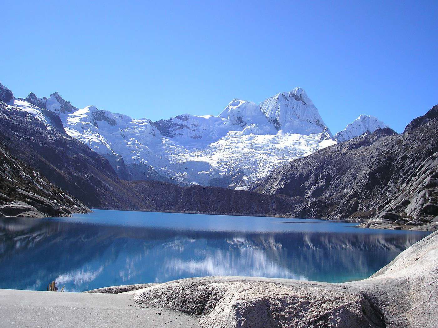
Il y'a deux camps de base de l'alpamayo: le "nord"... et le "sud" 😉.
Dans les deux cas, nul besoin d'être alpiniste: ce sont des "camps de base" donc accessibles par la marche.
Le camp de base "sud" est accessible depuis la quebrada santa cruz. Je n'ai pas de temps de marche précis à te donner, mais disons que le détour devrait prendre quelque chose comme 2 à 3 heures A/R.
La vue ne vaut pas vraiment le détour, sauf éventuellement si la météo est bonne et que tu montes auprès du lac: les sommets alentours ont pas mal d'ice flutes et c'est assez joli.
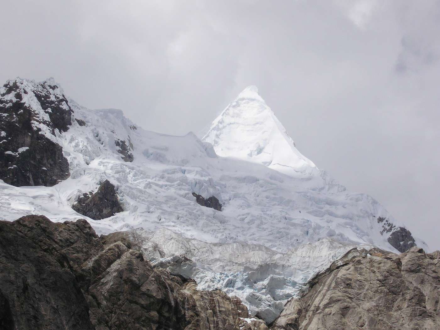
La meilleure vue sur l'alpamayo est sans conteste coté nord. En fait, on ne le voit pas du camp de base, par contre, on le voit très bien au bout de quelques dizaines de minutes de marche en partant de la laguna Jancacurish vers le camp de base.
Je n'ai pas pris le temps de le faire - à regrets - mais je pense que ça doit valoir le coup d'aller au "camp haut". Du camp bas, il y'a une vue assez joli sur les pics de santa cruz.
Merci Samuel pour ces précisions .... et je suis revenue sur ton
très beau carnet de voyage qui m'avait déjà fort intéressée il y a quelques mois !!
Bon, je vois que tu tournes dans l'autre sens : peut-être une meilleure idée pour aller voir
plus facilement le camp de base nord ( les jambes et l'acclimat seront au top )
A +
C B
>>Merci Samuel pour ces précisions .... et je suis revenue sur ton
>>très beau carnet de voyage qui m'avait déjà fort intéressée il y a quelques mois !!
Merci pour ces compliments 😊.
>>Bon, je vois que tu tournes dans l'autre sens : peut-être une meilleure idée pour aller voir
>>plus facilement le camp de base nord ( les jambes et l'acclimat seront au top )
Ce n'est pas sûr que ce soit une bonne idée. Ce trek peut vraiment se faire dans un sens ou dans l'autre.
Par contre, c'est clair que j'avais souhaité commencer par la Q. Santa Cruz parce que ce sens est préférable pour l'acclimatation.
Je n'étais pas acclimaté d'où ce choix, mais sinon, je l'aurais bien fait en sens inverse.
Le camp de base nord est à 4400m - du moins le camp de base "bas". Avant d'y aller, en commencant la moitié nord, tu dois passer un col à 4800m et avoir un bivouac vers 4600m le 2eme jour :: c'est clair qu'il faut être acclimaté.
Comment as tu prévu de faire ce trek ? Seule ? En Groupe ? Avec une agence péruvienne ? Avec un muletier de Cashapampa ?
As tu commencé à réfléchir aux campements possibles ?
J'ai adoré ce trek, mon préféré en amérique du sud.
Les montagnes de la cordilliere blanche n'égalent pas la grandeur, la lumière de l'himalaya népalais, les stupas bouddhistes ...
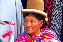
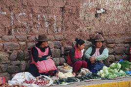
Mais ce sont de très belles montagnes pour peu qu'on prenne le temps de les découvrir (quel bon choix de ne pas se limiter aux autoroutes du trek de Santa Cruz !!), et dans mes souvenirs, je ne me lasse pas de la gentillesse des péruviens de cette région, de leur perpetuelle bonne humeur, des couleurs de leur vetements .... ggggrgrrrrr, tu m'as donné envie d'y retourner 😉 !
Je m'inspire du Tour de l'Alpamayo de Vincent Geus et nous voyagerons à 2 en prenant
un muletier de Cashapampa sur place hors groupe et surtout hors agence si c'est possible .
Avant de partir pour ce tour nous pensons faire quelques balades d'acclimatation depuis
Huaraz, Yungay ou Caraz : là où il y aura le moins de monde ....
Nous ne sommes pas adeptes des foules !
Si tu as un autre plan Pérou - Bolivie nous sommes preneurs 😉
On rêve d'un petit 6000 facile mais ça sera pour une autre vie ...
On s'y est pris trop tard dans cette vie 🤪
Merci
C B
J'ai fait le trek Cashapampa - Pomabamba via le camp de base de l'Alpamayo Nord. L'interet c'est que c'est un itineraire tranquille avec tres peu de touristes (je n'en ai rencontre aucun, en fait). Effectivement, cela commence par une tres tres longue montee. Ce trek m'a pris 6 jours, relativement relax.
J'ai aussi fait Llanganuco - Santa Cruz, mais pas la meme annee.
Trek de Los Cedros et Alpamayo côté nord fait en mai avec presque personne
+ un temps superbe !!! et un arriero d'une grande attention 🙂
Très bonne acclimatation avec 2 petites balades en altitude:
Super belvédère (de la Cordillère Noire vers toute la Cordillère Blanche) à l'ouest de Caraz :
vue panoramique sur le Huascaran, l'Huandoy et l'Alpamayo !!
Puis lac Paron.
Bonsoir Chantal,
Suite à ton message du 18 septembre 2007 sur le trek de l'ALPAMAYO où apparemment du t'es régalée, j'aimerais te demander quelques précisions :
Combien de temps a duré ce trek ?
Où est le point de départ?
Apparemment, tu n'es pas passée par agence, tu as donc pris un arriero sur place... combien de temps avant le départ?.
Quel a été le cout de ce trek?.
Beaucoup de questions, mais notre groupe de 4 personnes arrive à LIMA le 15 mai prochain pour faire essentiellement deux treks, l'un dans le cordillère HUAYHASH puis l'autre dans la cordillère blanche; nous sommes donc en pleine préparation.
Je te remercie de ton aide et de tes conseils.
J'attends ta réponse avec impatience.
Marie Jo
Bonjour Mauléon .... beau pays !!!
Nous avons choisi de faire un A/R jusqu'au pied de l'Alpamayo nord.
Basés à Caraz, je conseille cette petite ville pour son calme, son marché et la proximité de balades à la journée pour l'acclimatation.
Nous avons été voir Pony's Expeditions à l'angle de La Plaza pour le trek de los Cedros en 5-6jours : Alberto est de bon conseil.
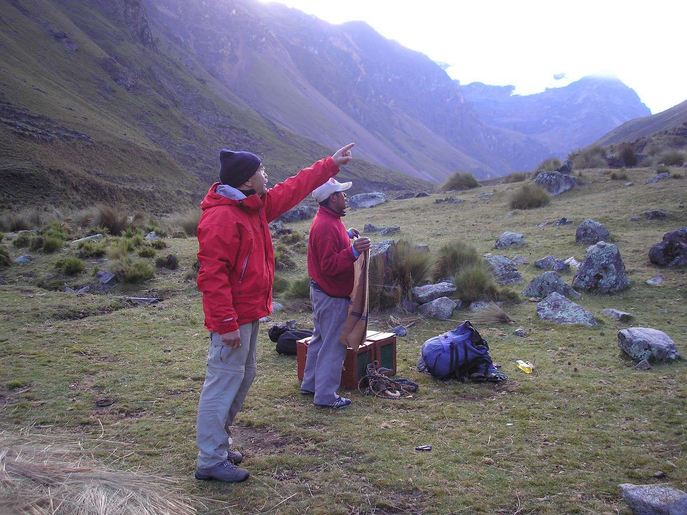
1 arriero LUIS - 2 ânes - caisses pour la nourriture - nourriture 3pers/6 j - réchaud-gaz -tente cuisine -: total 190 euros pour 2 personnes.
Seuls à cette période. Topo de Vincent Geus et carte de la Cordillère Nord
Alpenvereinskarte 0/3a.
Départ Hualcayan et retour à Cashapampa chez Luis (via les Baños).
Tu peux continuer par Gara Gara et enchaîner le trek de Santa Cruz: plus long.
En MP je peux essayer de t'envoyer un morceau de carte (après mercredi).
Adio
C B
P S: pour arriver à Caraz : Lima-Chimbote bus luxe ..côte désertique
Chimbote-Caraz via le Cañon del Pato bus rustique ...superbe!
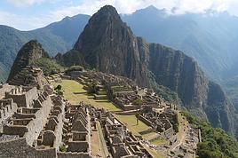
Photos: Les Santa Cruz - Alpamayo - Camp Ruina Pampa
Nous aimerions faire le tour de l'Alpamayo en avril. J'ai trouvé une carte sur internet décrivant le circuit. Pourrais-tu me dire quelles sont les différentes étapes par jour ? Combien de kilomètres fait le tour de l'Alpamayo ? En combien de jour ce fait-il ?As-tu réservé le trek auprès de Pony's Expeditions.
Hola
Pour Avril ...c'est encore trop tôt en montagne .... tu vas te mouiller
et manquer la vue sur les sommets
Il faut attendre la mi-mai .... si tu peux pousser ton voyage..
Nous n'avons pas fait le tour de l'Alpamayo mais un aller-retour par le côté Nord
de l'Alpamayo via les Santa Cruz ( voir la réponse au-dessus): Trek de Los Cedros
ou Au pied de l'Alpamayo (Vincent Geus )
Pony's Expeditions nous a fourni le muletier, sa tente et le réchaud.
Nous avons notre propre matos tente-couchage .... on sait ce qu'on a ...
Ce trek se fait tranquille en 5 bivouacs- 6 jours, 77 Km, 3200m de dénivelé +....
Pour le trek du Tour de l'Alpamayo 10 jours, 129 Km, 6300m dénivelé+ cumulé et
6300m de dén-- cumulé.
Sur le topo de Vincent Geus les 4 premières étapes sont communes au nôtre.
L'acclimatation est à prendre en compte (4850m)
Bon trek
Malheureusement pour une question de timing il est prefereable que je parte en avril au Perou. Est-ce que le temps est si terrible que ca a cette periode ?
Hola
Nous avions un peu "grenouillé" à Caraz vers le 8 mai car Alberto de Pony's Exp était en vacances et l'agence en repos ....
On en a profité pour faire de l'acclimat.
Nous avons attendu son retour et il nous a conseillé de laisser encore quelques jours pour assurer le beau temps à partir du 12 mai ... dont acte ..;et beau temps !
Je ne peux pas t'en dire plus ... nous partons toujours fin avril .... et il fait beau
A+ Chantal
Ne vous attendez pas a un temps 100 % degage, mais il ne pleut pas trop et le trekking est possible (en plus, tres peu de touristes). J'ai moi-meme fait l'Alpamayo Nord en (fin) avril (seul).
Ce message pour avoir quelques renseignements au sujet du trek de l’Alpamayo que nous, mon amie et moi-même, avons l’intention de faire fin mai. Nous avons…
Y a t-il une possibilité d'aller voir la montagne Vinicunca (rainbow mountain) sans faire tout le trek du tour de l'Ausangate? Il s'agit de la montagne colorée…
Je souhaiterais savoir si le trek du tour du Huyhuash au Perou un mois d aout est faisable seul sans guide ni muletier sans trop de risque de se perdre? Merci…
Je suis ambivalent concernant la visite du Canon de Colca (Peru). J'hésite entre: 1- prendre un tour organisé (2 jours/1 nuit) à partir de Arequipa, et à…
Nous prévoyons de partir au Pérou pour visiter Cusco et la vallée sacrée début Mai. Nous avons 2 enfants de 8 et 10ans et voudrions faire un trek sur place. Il…
Hi,
We’re planning to do the 4-day trek from Mestia to Ushguli without an agency. The descriptions mention that there are accommodations at each stop, but we can’t find any details about them. Has anyone got info or feedback on this route?
We're planning to trek in Peru and Bolivia and would love to find some local agencies.
If you know any, could you share details on prices and, of course, the names of the agencies?
Which trek would you recommend?
Elocine
Je pars en autonomie totale sur un trek au Maroc (10jrs) Imilchil - Aghbalou.
Trouve t-on des cartouches gaz à vis (Coleman, Primus) à Marrakech (adresse) ou villages entre Imilchil - Aghbalou ?
Si non , trouve-t-on des cartouches Butagaz pour camping-gaz (petit volume 230 gr ...)
Merci d' avance pour vos réponses
Hello, I’d like to embark on a little trip in my home country, Switzerland. I’ll start walking from La Cure, heading toward Le Noirmont first, then I’ll improvise my route—but it’ll probably follow the French border... at least as far as Lac de Joux.
I’ll decide day by day how much farther to go after that. My goal is to stay in nature as much as possible, wander around for as long as I can, and restock food in villages or towns along the way.
I’m thinking of mostly camping, but we’ll see if I end up in a hotel or another campsite depending on my route.
I’d love to reach La Chaux-de-Fonds on foot... maybe even Delémont.
The whole thing should take about a week, give or take.
I’ll be bringing my dog, and I’m preparing for this as soon as I’m ready.
Any tips to make sure everything goes smoothly for us? Things I should know—or avoid? What about shepherds with their flocks of sheep? And isn’t hunting season open right now?
I’m not sure if what I’m planning is even doable, which is why I’m asking around.
This’ll be my first time doing something like this—wandering in nature *and* with a dog. I’m really excited for this adventure... and I need it. Thanks!
We’re really keen on ecosystems and want to hike in "natural" ancient forests—not planted woods or areas heavily degraded by human activity. Travel guides (like Lonely Planet) don’t provide much info on this. Could you point us to the most interesting spots?
Thanks in advance for your tips.
We wish you happy holidays and a fantastic 2026, full of discoveries!
Claire and Albert
Hi, this might not be the right section, but I’d like to know if it’s possible to start mountaineering with another person without necessarily hiring a guide. We’ve done quite a bit of hiking but not mountaineering—we’ll just do a half-day glacier course. After that, we were thinking of starting with La Grande Motte and the Pointe de la Traversière, which were recommended to us. Honestly, for things like roping up and knots, I’ll learn at home with lots of videos and a book.
Hi,
I don’t know Switzerland at all and was wondering if Vallée des Joux and especially Dent de Vaulion are packed early in the morning or late in the afternoon in July and September?
If so, do you have any quieter spots to recommend in the area, or in Luxembourg (yes, I know it’s not the same country 😉)?
Thanks a lot!
Jaimerais savoir si quelqu'un aurait fait des treks sur le Ruwenzori et combien ça coute en moyenne, les infrastructures, les paysages la sécurité sur les lieux, merci beaucoup. J'attends avec impatience vos réponses.
We’re leaving in 9 days for a two-week trip to Madeira, mainly to hike.
From my research, I’ve found that since last year, access to most trails—and systematically for the most popular ones—is now paid. You have to pay an access fee of 4.50 € per person per classified hike in 2026, and even 10.50 € for the most iconic hike: Pico Arieiro to Pico Ruivo. When paying, you also have to choose a day and a 30-minute time slot for your start time. Of course, this reservation is neither changeable nor refundable, even if the weather that day is terrible.
Personally, given the massive influx of tourists to the island in recent years, I don’t mind paying a fee to help maintain the trails. Similarly, setting a limit on the number of people who can hike them per day is certainly preferable to preserve this priceless heritage.
However, what’s much less fair is that in reality, most of the available spots are reserved: 1/ for Madeira residents (which is normal); 2/ for "economic operators" (meaning local tour operators). For example, if you’re a non-resident (independent tourist), no booking is possible for the Pico Arieiro hike for an early morning start before September! So, unfortunately, we’ll have to skip this hike.
It’s the same issue for Ponta de São Lourenço, the 25 Fontes, Pico Ruivo... in short, all the most popular hikes. Oh well, we’ll skip those too!
So my question is: which hikes do you recommend where we won’t face the huge crowds that the others get? And where we can book the day before for the next day, taking the weather into account?
Finally, a quick accommodation question: we’ve booked the first week in Funchal, but I haven’t decided yet for the second week. Do you have any advice on where to stay in the south or north, preferably avoiding overly concrete-heavy and touristy spots?
I’m reposting about the logistics for Samaria Gorge.
I’d love to get recent info, especially about whether it’s possible to park my car in Omalos, do the hike, and then catch a bus back to my vehicle.
In theory, it’s doable, but when you check the KTEL website, there aren’t any feasible schedules listed. If anyone has recently organized this with reliable, verified details, I’d really appreciate it. Thanks in advance!
Hi there,
We’re flying from Montreal to Lyon this August to go hiking in the French Alps. We’ve rented a car and will be staying at campgrounds. We’re planning to do day hikes and want to stay a few days in one spot, do a few hikes, then move on to our next camping spot. Could you share your favorite spots or any recommendations for places to spend a few days with great hikes?
A few details:
We arrive in early August and leave in early September.
We’re looking for day hikes (or shorter), moderate difficulty, with a cumulative elevation gain of no more than 1000m, and of course, beautiful scenery!
We’d prefer not to drive too much—maybe it’s best not to head too far south and deal with unnecessary heat?
Along the same lines, if you know of any great campgrounds where we can start our hike directly without needing the car, we’d love to hear your suggestions!
Bonjour
Souhaitant faire de la randonnée sur cette île, je voudrais d'abord savoir quelle serait la période la plus favorable sachant que j'avais passé quelques jours en novembre 2018 pas pour cette activité mais plus pour une simple découverte de l'île et le temps n'était pas top notamment en montagne. Donc peut on choisir une organisation en étoile sachant que je louerai un véhicule avec éventuellement 2 points d'hébergement.
Je n'envisage pas d'intégrer une structure mais de partir à 2 et de s'organiser sauf si vous me conseillez une agence locale ou un guide local. Enfin même si je compte me procurer les différents supports, carte et topo guide plus gps je vous remercie de bien vouloir me communiquer les randos à faire en priorité
Merci beaucoup pour vos informations
I’m planning to do the Mercantour crossing following the Randoxygène route in mid-July.
I’m used to hiking in the mountains, but I sometimes get vertigo, for example on ridges with drops on both sides. I wanted to check if there are any T4 or T3-T4 sections and find out if there are any very exposed passages—and if so, where—so I can plan an alternative route.
Can anyone give me some info on this?
Thanks!
I’m planning a trip around Cap Corse and the AGRIATES in 2026, from May 8th to 15th (there are still 2 spots left, by the way! Just DM me if you're interested).
I’d love to know which hikes are worth prioritizing in the AGRIATES. We’ll be staying in SALECCIA for two days as our base—what should we focus on from there?
A round trip to IGNHU beach? Any other suggestions?
For Ostricano, I think it’s too far for a round trip...
Thanks for your tips!
Have a great day,
Anie, Toulouse
I’d like to get some info about the GR10 Pyrenees traverse. I need help planning the daily stages and accommodations—my wife isn’t an experienced hiker but walks a lot, so I’d like to schedule shorter walking days and thus a longer overall trip in terms of number of days.
Could anyone give me some help and advice?
Best regards,
New to this forum, I’m planning a pretty big project for 2028.
I’m heading to Nepal to do a trek from Kathmandu all the way to Everest Base Camp (a cool 5,300 m 😄).
This trek is a bit special because even though I’ll be part of a group, I’m going solo (so far, no problem—I’m used to it). But it’s my first real trek, and it’s also a humanitarian one: once I reach base camp, I’ll stay an extra week to help clean up the waste left by tens of thousands of climbers! Since I’m originally from South America, from two countries that share the Andes, I have a deep respect for mountains—they fascinate me. So Everest… it’s kind of the trip of a lifetime!
So, a little question for those who’ve done treks to Everest before… any tips for good mental preparation (I’m already working on the physical side)?
Hi there, I’m planning the Annapurna Circuit for March 2027 and I’m looking for a local agency with a local guide—preferably French-speaking—to arrange this trek for us. Any suggestions? Thanks
Hello!
We’re spending a few days in Toraja country at the end of May. We’d love to do a day trek—taking our time—on a route that’s stunning in terms of scenery, but not a level 5 in difficulty!
Any suggestions you can share, please?
Thanks in advance
I’d like to do the Mare a Mare Sud in May over 4 days. I’ve found quite a few places to stay along the route, but I’m stuck on the start and finish.
I’ll be arriving by plane on Sunday evening and would like to start pretty early on Monday morning. Ideally, accommodation right at the trailhead (Alzu di Gallina) would be amazing, but I can’t find anything. Any tips?
Also, for the transfer from Figari Airport to Porto Vecchio or Alzu di Gallina?
At the end, I’d like to pick up a rental car—any advice on that too?
I’m traveling solo by plane to Catania in May and plan to hike the northern side of Etna, starting from Linguaglossa where I’ll arrive by bus. After that, I’d love some info on how to get up to Piano Provenzana (shuttles or hitchhiking), since it seems there’s no public transport except in the summer. Can you sleep there in a free or cheap refuge, or camp? And how far up can you go without having to hire a guide? Thanks in advance. Bernard.
Bonjour a tous,
je pars en voyage au Maroc en aout et nous allons commencer par nous arrêter a Chefchaouen(nous sommes en voiture).
Ma question: quelqu'un peut il m'indiquer un itinéraire de rando en boucle d'entre 5 et 7 jours aux départ de Chefchaouen dans le parc de Talassemtane passant si possible par le pont de dieux?Ou un guide papier qui en reunis quelques uns?
Nous privilégions le camping sauvage et les gites.
Merci d'avance
Hi there, for those who’ve been recently—is it possible to find other solo travelers in March on the island to share transport or room costs? It doesn’t seem easy to travel on a budget.
If you have any recommendations for simple lodgings or places with dorms, I’d love to hear them.
For those who’ve done multi-day treks while moving around: do you need to bring your own sleeping bag? I’d love to hear about itineraries you’ve done without a guide, just with a map and GPS.
Thanks, and have a great day!
Hi everyone!
We’re planning a 15-day road trip to Scotland this summer, specifically to explore and hike on Lewis and Harris—places we’ve never been before. We’ve visited other islands on previous road trips in Scotland (we usually go in April for a week). This would be our first time in Scotland in the summer and for 15 days. We’re looking at late August to early September.
I’m currently drafting the itinerary. We’d be crossing from Ullapool and were thinking of spending 3 nights on Harris and 4 nights on Lewis.
Does that sound balanced to you? Is it better to keep the same accommodation on Harris and the same on Lewis to explore the area? I’d love to hear about any past experiences you’ve had on these islands.
Thanks!
Hi there, I’m trying to leave for 15 days very soon to São Vicente. I’m either looking to join an agency or figure things out on my own to go hiking on one of these islands or both. From what I’ve seen, it’s not easy to organize with local transport, so it gets expensive. Can I use the services of a small local agency? I’m looking for the simplest way to hike for several days. Also, how do you get from São Vicente to São Nicolau? Thanks in advance and have a great day!
Aichatou
I’ve been wanting to do this for several years, and this year’s the one. Next September, I’ll be trekking in Tusheti (Georgia), from Omalo to Shatili.
Of course, I won’t be renting a vehicle that’d just sit unused. No problem getting to Pshaveli, but from there to Omalo, it’s a dirt road (still the case?)
There must be some form of public transport since there are so many guesthouses, and not all travelers come in a 4x4.
If any of you have been to Omalo, could you confirm that these shared transports exist and how often they run?
we’re planning a trip to Yellowstone and hoping to do a three-day backcountry hike if we get a permit.
if any of you have done this before, could you let me know if it’s possible to find water along the way? And if we can transport it, are we allowed to use a stove?
Hello,
I’ll be in Nepal from March 6th to 29th (we’re flying into Kathmandu via Varanasi and leaving via Delhi).
I’m a bit confused about the regulations requiring a guide.
My wife and I (we’re 63 and 64) aren’t experienced trekkers—we’re more used to walking on terrain with very moderate elevation changes. I’m looking for fairly easy hikes, possibly day trips.
Here are my questions:
- Does the Poon Hill trek from Pokhara require a guide, or is it better to go through a local agency? (I’ve seen a lot of them offering 4-day packages)
- I’d like to do a few multi-day hikes around Jomsom (Kagbeni, Mukitinath, Lupra, Marpha)... Do you need a guide for those, and can you find accommodations easily without booking in advance?
Last question—I’m really hesitant to lug around a sleeping bag or down jacket during our 6 weeks in India. Can you easily find these kinds of items at reasonable prices in Pokhara?
Thanks in advance for any tips you can share!
Yann