Hello, I spent a month cycling in Thailand earlier this year with a touring bike equipped with two rear panniers. I loved being able to ride and stop at a hotel every night, and eat just about anywhere. I tried India two months ago but gave up because of the road conditions and chaotic traffic.
I’m looking for countries where I can cycle "without autonomy"—so no tent, no stove, just the bare minimum. Ideally, I’d like to stop at hotels or similar accommodations regularly, without having to cover 200 km a day!
I’d love to hear from your experiences—what countries make it easy to travel this way? Thanks!
Hello,
I’m planning to cycle from Paris to Prague in three weeks. It’s the worst time of year temperature-wise, especially since I’m pretty sensitive to the cold. But I don’t have a choice about either the timing or the destination (it’s a break between two jobs that just happens to fall during this period, and I’m heading to Prague to meet friends for a specific event in mid-February).
So it’s going to be *very* cold. And while I’ve done a few relaxed one- to two-week bike trips before, I’ve never cycled in winter. That’s why I’d love your advice on two things! :)
1- Accommodation along the route On my previous trips, the weather was more forgiving, so I always brought my tent and didn’t have to worry about accommodation logistics. But this time, it’s a whole different story—I won’t be able to sleep outside (too cold + it gets dark too early). So I need to plan all my lodging in advance.
I’ve looked at a few existing threads about cycling from Paris to Prague, but they all focus on campsites/tents since the timing allowed for outdoor sleeping. Does anyone know: 1- If those campsites, which seem to be fairly evenly spaced along the route, have winter facilities (I assume most close in winter, but you never know)? This is especially important for the German and Czech sections (I’ll be fine in France). 2- How easy it is to find affordable youth hostels everywhere, and if so, whether I should book them in advance?
2- Winter cycling gear Since I’ve never cycled in winter before, I don’t have the right gear. I’m particularly concerned about gloves and shoes, since my extremities will take a beating. What shoes would you recommend for temperatures around 0°C? I don’t plan to cycle in winter again after this, and all my other trips have been in regular running shoes, which worked just fine for me. So I’d prefer not to spend a fortune on super technical gear that I’ll only use once. But I also don’t want to skimp on cold protection—being freezing could ruin the whole trip. So if the only solution is "super technical" shoes, I’ll go for it.
> What shoes do you wear or recommend for simple bike trips that keep your feet warm and dry? > Does the overshoe option (over a pair of regular sneakers, for example) seem like a good solution? (I just discovered overshoes—I have no idea how effective they are.) If so, are Decathlon’s overshoes good enough, or should I go to a specialty bike shop?
Thanks so much!
(Oops, sorry for the novel...)
I’m planning to cycle from Paris to Prague in three weeks. It’s the worst time of year temperature-wise, especially since I’m pretty sensitive to the cold. But I don’t have a choice about either the timing or the destination (it’s a break between two jobs that just happens to fall during this period, and I’m heading to Prague to meet friends for a specific event in mid-February).
So it’s going to be *very* cold. And while I’ve done a few relaxed one- to two-week bike trips before, I’ve never cycled in winter. That’s why I’d love your advice on two things! :)
1- Accommodation along the route On my previous trips, the weather was more forgiving, so I always brought my tent and didn’t have to worry about accommodation logistics. But this time, it’s a whole different story—I won’t be able to sleep outside (too cold + it gets dark too early). So I need to plan all my lodging in advance.
I’ve looked at a few existing threads about cycling from Paris to Prague, but they all focus on campsites/tents since the timing allowed for outdoor sleeping. Does anyone know: 1- If those campsites, which seem to be fairly evenly spaced along the route, have winter facilities (I assume most close in winter, but you never know)? This is especially important for the German and Czech sections (I’ll be fine in France). 2- How easy it is to find affordable youth hostels everywhere, and if so, whether I should book them in advance?
2- Winter cycling gear Since I’ve never cycled in winter before, I don’t have the right gear. I’m particularly concerned about gloves and shoes, since my extremities will take a beating. What shoes would you recommend for temperatures around 0°C? I don’t plan to cycle in winter again after this, and all my other trips have been in regular running shoes, which worked just fine for me. So I’d prefer not to spend a fortune on super technical gear that I’ll only use once. But I also don’t want to skimp on cold protection—being freezing could ruin the whole trip. So if the only solution is "super technical" shoes, I’ll go for it.
> What shoes do you wear or recommend for simple bike trips that keep your feet warm and dry? > Does the overshoe option (over a pair of regular sneakers, for example) seem like a good solution? (I just discovered overshoes—I have no idea how effective they are.) If so, are Decathlon’s overshoes good enough, or should I go to a specialty bike shop?
Thanks so much!
(Oops, sorry for the novel...)
Hi everyone,
I’m heading to Chile this coming November and I’d love to spend a few days cycling from Santiago (Chile) to Mendoza (Argentina).
Has anyone done this route before? If so, do you have any tips (stages, gear, accommodation spots, etc.)?
Also, to avoid carrying too much stuff, I’d like to rent a bike in Santiago. Any recommendations for a good rental shop?
Thanks so much in advance for your help :)
Clément
I’m heading to Chile this coming November and I’d love to spend a few days cycling from Santiago (Chile) to Mendoza (Argentina).
Has anyone done this route before? If so, do you have any tips (stages, gear, accommodation spots, etc.)?
Also, to avoid carrying too much stuff, I’d like to rent a bike in Santiago. Any recommendations for a good rental shop?
Thanks so much in advance for your help :)
Clément
Hi there,
We’re leaving from Montreal and planning to bike the Petit Train du Nord route.
Any ideas for loops so we don’t have to return the same way?
We’re thinking of a one-week trip.
Thanks in advance for your tips!
Rachel
Assalamu 'alaykum,
Hi everyone,
This thread is to echo some posts I’ve read on this forum while researching a potential bike trip from Annecy to Mecca. I came across several discussions where members mentioned being very interested in cycling to the holy city.
So, God willing, I plan to attempt this journey from January to June next year. The idea is to head to Turkey first, then assess the most reasonable routes based on the geopolitical situation around Palestine and as far as Iraq. Since the Turkish-Syrian border is closed, the only remaining (and I mean *only* remaining) overland option would be to go through Iraqi Kurdistan, Iraq, then Jordan, and finally Saudi Arabia.
That’s the first major challenge of this project. The second is timing. Due to the schedule, I’ll be starting in the middle of winter across Europe and finishing in the peak of summer in Saudi Arabia. If I’d had a choice, I’d have waited a good dozen years—but well, twelve years...
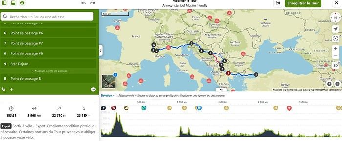
I won’t go into too much detail about the planned route in this post, but here are the broad strokes already set: Annecy to Istanbul. The rest is a bit too far ahead to map out properly. Crossing the Italian border via the Montgenèvre Pass. Straight through northern Italy as quickly as possible (not necessarily very pleasant) to reach Ljubljana. The fastest route through Croatia to spend as much time as possible in Bosnia-Herzegovina. Serbia via the Sandžak region. It crosses the Pešter plateau, which intimidates me at this time of year—its nickname, the "Siberia of the Balkans," says it all... Then Kosovo, North Macedonia, Greece, and Turkey.
I’m open to any advice on this itinerary. The choice was made to pass through as many Muslim-majority regions as possible. In the middle of winter in the Balkans, I don’t feel mentally up to bivouacking alone in that climate. So, I’ll try to find accommodations in mosques or even with locals as much as possible.
That’s the project in a nutshell. The big catch—some of you may have already noticed—is that I’m doing this solo. Yet, this is strongly discouraged by our Prophet—peace and blessings of Allah be upon him. So, I invite anyone interested in joining this project, whether closely or from afar, to reach out and contact me. Any contribution is welcome, whether it’s company for the whole journey (one can always hope!) or just part of it. Advice, contact suggestions, places to stay, and information about Hajj or Umrah are also appreciated.
Thanks for reading this far. I’ll try to check my VoyageForum account from time to time to see if anyone has responded to this thread and will happily reply to your messages and questions.
Take care, Assalamu'alaykum.
Sam
This thread is to echo some posts I’ve read on this forum while researching a potential bike trip from Annecy to Mecca. I came across several discussions where members mentioned being very interested in cycling to the holy city.
So, God willing, I plan to attempt this journey from January to June next year. The idea is to head to Turkey first, then assess the most reasonable routes based on the geopolitical situation around Palestine and as far as Iraq. Since the Turkish-Syrian border is closed, the only remaining (and I mean *only* remaining) overland option would be to go through Iraqi Kurdistan, Iraq, then Jordan, and finally Saudi Arabia.
That’s the first major challenge of this project. The second is timing. Due to the schedule, I’ll be starting in the middle of winter across Europe and finishing in the peak of summer in Saudi Arabia. If I’d had a choice, I’d have waited a good dozen years—but well, twelve years...
I won’t go into too much detail about the planned route in this post, but here are the broad strokes already set: Annecy to Istanbul. The rest is a bit too far ahead to map out properly. Crossing the Italian border via the Montgenèvre Pass. Straight through northern Italy as quickly as possible (not necessarily very pleasant) to reach Ljubljana. The fastest route through Croatia to spend as much time as possible in Bosnia-Herzegovina. Serbia via the Sandžak region. It crosses the Pešter plateau, which intimidates me at this time of year—its nickname, the "Siberia of the Balkans," says it all... Then Kosovo, North Macedonia, Greece, and Turkey.
I’m open to any advice on this itinerary. The choice was made to pass through as many Muslim-majority regions as possible. In the middle of winter in the Balkans, I don’t feel mentally up to bivouacking alone in that climate. So, I’ll try to find accommodations in mosques or even with locals as much as possible.
That’s the project in a nutshell. The big catch—some of you may have already noticed—is that I’m doing this solo. Yet, this is strongly discouraged by our Prophet—peace and blessings of Allah be upon him. So, I invite anyone interested in joining this project, whether closely or from afar, to reach out and contact me. Any contribution is welcome, whether it’s company for the whole journey (one can always hope!) or just part of it. Advice, contact suggestions, places to stay, and information about Hajj or Umrah are also appreciated.
Thanks for reading this far. I’ll try to check my VoyageForum account from time to time to see if anyone has responded to this thread and will happily reply to your messages and questions.
Take care, Assalamu'alaykum.
Sam
For map lovers, bike routes, cycle touring all over the planet, and long-haul trips...
I had fun compiling in one place ALL the routes my partner and I have biked across the planet since 1996: Quebec far and wide, of course, but also Canada, the USA (crossed completely by bike 3 times), Mexico, and all the way to Ushuaia—basically the entire Americas.
In Europe, the Balkans, Turkey; and more recently (2024: Taiwan, Korea, and 4 months in Japan!) You can check out a global map with all the routes by continent, more detailed maps by country, and others that focus on a region, like the Balkans in Eastern Europe. In short, there’s something for everyone!
I’ve included 3 photos here, but the originals (via the link above) let you zoom in infinitely. Plus, many of my routes are represented by lines with a different color for each day of biking. Hope some of you enjoy browsing through all this as much as I enjoyed compiling it. Until the snow comes, skiing... and spring!
https://www.crazyguyonabike.com/doc/TDM_en_Tandem_Trajets_Maps
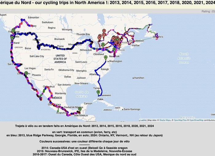
I had fun compiling in one place ALL the routes my partner and I have biked across the planet since 1996: Quebec far and wide, of course, but also Canada, the USA (crossed completely by bike 3 times), Mexico, and all the way to Ushuaia—basically the entire Americas.
In Europe, the Balkans, Turkey; and more recently (2024: Taiwan, Korea, and 4 months in Japan!) You can check out a global map with all the routes by continent, more detailed maps by country, and others that focus on a region, like the Balkans in Eastern Europe. In short, there’s something for everyone!
I’ve included 3 photos here, but the originals (via the link above) let you zoom in infinitely. Plus, many of my routes are represented by lines with a different color for each day of biking. Hope some of you enjoy browsing through all this as much as I enjoyed compiling it. Until the snow comes, skiing... and spring!
https://www.crazyguyonabike.com/doc/TDM_en_Tandem_Trajets_Maps
A firsthand account of a 30-day cycling trip (the length of the visa) in southern Vietnam, from Hue to the Mekong Delta. 1,500 kilometers pedaled in December 2022 and January 2023.
Roads and Traffic The roads are generally in very good condition. The secondary road network is limited. Since Vietnam is a densely populated country, needless to say, traffic is often heavy, including on secondary roads. Cyclists, along with pedestrians, are at the very bottom of the road-user hierarchy. In short, when you're on a bike, you never have the right of way. The atmosphere is deafening—Vietnamese people honk all the time. For a Western ear, it's hard to tell the difference between a honk that just signals someone's presence, one that warns of imminent danger, or an angry honk. 😏
Weather Vietnam is a long, narrow country (1,600 km). The weather isn’t the same in the north, center, or south. I cycled through the central part in December. Even though the monsoon peak had passed, I still encountered a lot of rain. Since the monsoon usually lasts until January, it might be better to cycle there starting in February. I was in the Mekong Delta in January. The best season, as it’s the driest month with the least hot temperatures. At this time of year, the prevailing winds come from the northeast. So, it’s better to travel from north to south. That way, you’ll usually have the wind at your back.
Accommodation I always stayed in hotels without ever booking in advance. Typically, I paid between 10 and 20 € for a double room with a private bathroom and AC. To find hotels, I used Google Maps and Maps.me. Wi-Fi is available for free almost everywhere.
The Route Hue → Danang → Hoi An → Nha Trang → Phan Rang → Tan Son → Dalat → Di Linh → Mui Ne → La Gi → Vung Tau → Nha Be → My Tho → Tra Vinh → Can Tho → Cao Lanh → Tranh Hoa → Trang Bang I took the train from Danang to Nha Trang. Not all trains accept bikes, so you’ll need to check beforehand. The railway handles bikes—they’re packed by staff and travel in the same train but in a freight car. I paid 14 € for the ticket plus 7 € for the bike (there’s an extra 0.50 € to pay upon arrival).
The Verdict So, is cycling in Vietnam worth it? If you enjoy biking in traffic, then yes. Otherwise... 😎
Roads and Traffic The roads are generally in very good condition. The secondary road network is limited. Since Vietnam is a densely populated country, needless to say, traffic is often heavy, including on secondary roads. Cyclists, along with pedestrians, are at the very bottom of the road-user hierarchy. In short, when you're on a bike, you never have the right of way. The atmosphere is deafening—Vietnamese people honk all the time. For a Western ear, it's hard to tell the difference between a honk that just signals someone's presence, one that warns of imminent danger, or an angry honk. 😏
Weather Vietnam is a long, narrow country (1,600 km). The weather isn’t the same in the north, center, or south. I cycled through the central part in December. Even though the monsoon peak had passed, I still encountered a lot of rain. Since the monsoon usually lasts until January, it might be better to cycle there starting in February. I was in the Mekong Delta in January. The best season, as it’s the driest month with the least hot temperatures. At this time of year, the prevailing winds come from the northeast. So, it’s better to travel from north to south. That way, you’ll usually have the wind at your back.
Accommodation I always stayed in hotels without ever booking in advance. Typically, I paid between 10 and 20 € for a double room with a private bathroom and AC. To find hotels, I used Google Maps and Maps.me. Wi-Fi is available for free almost everywhere.
The Route Hue → Danang → Hoi An → Nha Trang → Phan Rang → Tan Son → Dalat → Di Linh → Mui Ne → La Gi → Vung Tau → Nha Be → My Tho → Tra Vinh → Can Tho → Cao Lanh → Tranh Hoa → Trang Bang I took the train from Danang to Nha Trang. Not all trains accept bikes, so you’ll need to check beforehand. The railway handles bikes—they’re packed by staff and travel in the same train but in a freight car. I paid 14 € for the ticket plus 7 € for the bike (there’s an extra 0.50 € to pay upon arrival).
The Verdict So, is cycling in Vietnam worth it? If you enjoy biking in traffic, then yes. Otherwise... 😎
Hi everyone,
First post here to share a quick recap of our west-to-east bike trip along Algeria’s coast in January 2025. It was just the two of us—my partner and I—with French passports and not a word of Arabic. No friends or welcoming hosts in the country.
Under those conditions, we’d strongly advise against going.
Our original plan was to follow the coast from Algiers to Tunis. We ended up cycling from Algiers to Béjaia, then took the train from Béjaia to Annaba (with a stop in Constantine), and finally biked to the border. We were tailed by police the whole way—whether on our bikes, on the train, or even on foot while exploring towns. On top of that, we couldn’t wild camp and were limited to the few state-approved hotels that accept foreigners. Under those circumstances, connecting with locals was especially tough.
With such an omnipresent and intrusive police presence, we’d definitely recommend against this destination for bike touring. A really sad situation that completely cuts you off from the local population...
We’d been warned, we went to check it out, and we weren’t disappointed!
You’ve been warned.
First post here to share a quick recap of our west-to-east bike trip along Algeria’s coast in January 2025. It was just the two of us—my partner and I—with French passports and not a word of Arabic. No friends or welcoming hosts in the country.
Under those conditions, we’d strongly advise against going.
Our original plan was to follow the coast from Algiers to Tunis. We ended up cycling from Algiers to Béjaia, then took the train from Béjaia to Annaba (with a stop in Constantine), and finally biked to the border. We were tailed by police the whole way—whether on our bikes, on the train, or even on foot while exploring towns. On top of that, we couldn’t wild camp and were limited to the few state-approved hotels that accept foreigners. Under those circumstances, connecting with locals was especially tough.
With such an omnipresent and intrusive police presence, we’d definitely recommend against this destination for bike touring. A really sad situation that completely cuts you off from the local population...
We’d been warned, we went to check it out, and we weren’t disappointed!
You’ve been warned.
Hi there,
I’d like to cycle around Guadeloupe during the Christmas holidays. I was wondering if it’s dangerous, if it’s easy to rent a bike, and to find accommodation along the way? Thanks!
Hi there,
The full route from Burgos to (just before) Murcia is 1,300 km.
If you’ve done the whole thing, do you think the entire route is worth the trip, or can some sections be skipped?
Thanks.
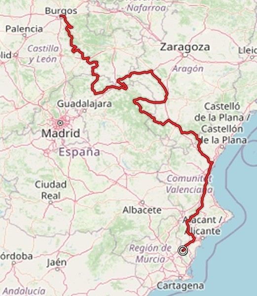
The full route from Burgos to (just before) Murcia is 1,300 km.
If you’ve done the whole thing, do you think the entire route is worth the trip, or can some sections be skipped?
Thanks.
hi fellow cyclists!
Outside, the weather isn’t great for bike escapes! But that doesn’t stop us from planning ahead. Starting to look at a map or other resources is when the journey begins! So, what are your plans? For us, there’s a trip in the drawer ready for a few months now—heading south (Montpellier) from the Allier department! Another idea has been taking shape: Corrèze, Périgord!!! Looking forward to reading your replies, have a great day! !
Outside, the weather isn’t great for bike escapes! But that doesn’t stop us from planning ahead. Starting to look at a map or other resources is when the journey begins! So, what are your plans? For us, there’s a trip in the drawer ready for a few months now—heading south (Montpellier) from the Allier department! Another idea has been taking shape: Corrèze, Périgord!!! Looking forward to reading your replies, have a great day! !
Hi everyone,
I’m trying to figure out how to get from Paris to Marseille or Montpellier with non-disassembled bikes by train in early July 2025... and it’s a total flop!!! Can’t find any trains that offer the bike-on-board option! It’s so complicated between SNCF-CONNECT, OUIGO, and TER INTERCITÉS!!! Nothing’s simple! I want to take my teens and their cousins on a bike trip to the Camargue, but I’ll have to start planning way ahead to sort out bike transport!!! So glad I found VoyageForum for tips! !
I’m trying to figure out how to get from Paris to Marseille or Montpellier with non-disassembled bikes by train in early July 2025... and it’s a total flop!!! Can’t find any trains that offer the bike-on-board option! It’s so complicated between SNCF-CONNECT, OUIGO, and TER INTERCITÉS!!! Nothing’s simple! I want to take my teens and their cousins on a bike trip to the Camargue, but I’ll have to start planning way ahead to sort out bike transport!!! So glad I found VoyageForum for tips! !
Hi everyone, could someone give me info on the track that starts from Tafraout toward M’harch Pass and then continues to Mcissi to join the national road heading west to Alnif? I’m planning to go in April 2025 by gravel bike/MTB. Is it doable? Is there a lot of soft sand??? How many km???? Thanks for any tips, and happy end of the year to all! Best, Rv.
Hi there,
I’m planning to cycle around Taiwan in 2026 and I’d love to know if it’s possible to do the whole island on bike paths, how many kilometers that would be, whether wild camping is easy, and so on…
Hi there,
No recent discussion here on the topic (2025).
Anyone else interested?
Hi there,
My friend and I are planning to bike down to Tierra del Fuego starting from Santiago, Chile, in early February. The big question is: "Is it possible to find decent and reasonably priced bikes in Santiago?" Are there local resale sites like Leboncoin, or any second-hand spots worth knowing about there? If anyone’s done this before, I’d love to hear your tips! ;)
Thanks! !
We're planning to cycle through Slovenia on touring bikes from July 14th to August 14th. We're used to camping, but I get the feeling there are large areas without campsites. Is wild camping allowed? If not, is it easy to stay with locals?
Could you tell me about the must-see spots in Slovenia? I'm thinking of finishing in Istria, at a seaside campsite to relax and enjoy the sea. Is it pretty quiet there?
Thanks so much, Mireille.
Could you tell me about the must-see spots in Slovenia? I'm thinking of finishing in Istria, at a seaside campsite to relax and enjoy the sea. Is it pretty quiet there?
Thanks so much, Mireille.
Does anyone know an easy way to get from Bilbao to Nantes by bus or train with a bike that isn’t disassembled?
Nothing on DB.DE, nothing on FlixBus...
Thanks.
Hi there,
I’m interested in guides and maps for the Vienna/Budapest and Budapest/Belgrade stretches.
We’re planning to leave from Passau to Belgrade in early August.
Hi there,
We’re planning a bike trip around Brittany this summer. We’re driving from Belfort and looking for a parking spot (paid) to leave our car for 4-5 weeks, from mid-June to mid-July, somewhere near Rennes.
Best regards,
Hi,
We’re planning to start the Camino del Cid from Vivar del Cid (Burgos) to Atienza in April.
How can we get back and pick up our car, which we left in Burgos? I haven’t found any info on this.
Thanks for your tips!
Hi, I’m looking for info on doing a solo bike trip from Chelyabinsk to northern China via Omsk. What’s the best time of year to go? Can I do it staying only in hotels and restaurants—without having to haul a tent, stove, etc.? Also, is there a border crossing point in northern China, because I can’t find anything on Google Maps? What’s the road condition like? Thanks
I'm developing a free and open-source web app for planning walking and cycling trips (and even car trips). You can create a route by clicking directly on the map to add waypoints, and it can consist of multiple stages. The app provides tools to edit the stages and the overall route, and to display useful information (distances, altitudes, and elevation changes). A relief profile can be shown as a graph for a specific stage or the entire route.
Once the route is ready, it can be exported as a GPX file, which can then be used with a GPS or a mobile navigation app.
The app is built in JavaScript and runs entirely in the web browser. It uses the Leaflet library and several OpenStreetMap-based services. Initially developed for my personal needs (I enjoy hiking and cycle touring), I’d be happy to share it with anyone who might find it useful. It’s free to use, doesn’t require an account, and the source code is available.
Source code: https://github.com/patricklmarie/GPX-Route-Planner Online demo: https://patricklmarie.github.io/GPX-Route-Planner/
Once the route is ready, it can be exported as a GPX file, which can then be used with a GPS or a mobile navigation app.
The app is built in JavaScript and runs entirely in the web browser. It uses the Leaflet library and several OpenStreetMap-based services. Initially developed for my personal needs (I enjoy hiking and cycle touring), I’d be happy to share it with anyone who might find it useful. It’s free to use, doesn’t require an account, and the source code is available.
Source code: https://github.com/patricklmarie/GPX-Route-Planner Online demo: https://patricklmarie.github.io/GPX-Route-Planner/
Hi there,
Just a few words about the loop I did by bike in Yunnan.
Entry and exit
I entered China through the Sino-Vietnamese border crossing at Lào Cai / Hekou under the 30-day visa exemption currently available to French nationals and others.
The process was simple and quick. A Chinese police officer even helped me complete my electronic pre-registration at a computer kiosk. I wasn’t aware this formality was required—it’s similar to Thailand’s TM6.
No issues with the bike.
I left the country via the Sino-Laotian border crossing at Mohan / Boten.
The atmosphere was a bit chaotic there, but again, no problems with the bike.
The timing
I visited Yunnan in February 2026.
Weather-wise, at higher altitudes (between 1,500 and 2,000 meters), it was around ten degrees at night and in the mornings, and around twenty degrees at the hottest part of the day.
I had two days of rain, so I took the bus to keep moving. Otherwise, clear blue skies.
Culturally, Chinese New Year fell on February 17th (and the 15 days following), right in the middle of my trip. Because of this, my take on the traffic might be off.
Accommodation and food I always found a hotel to stay in for prices ranging from 8 to 15 €. Except in Kunming (the capital), where many hotels were fully booked (Chinese New Year). I ended up at a 100 € hotel with great value for money.
A bowl of noodles costs about 1.5 € on average.
Onboard electronics Since my smartphone doesn’t support eSIMs, I subscribed to a China plan with my carrier. Otherwise, for much cheaper, Alipay offers eSIMs for foreigners that allow access to services usually blocked for Chinese users (WhatsApp, Facebook, etc.).
An internet connection is essential for paying with Alipay or WeChat, as this payment method is widespread.
I only managed to use Alipay.
Either way, always carry cash because sometimes there’s no signal, or the merchant only accepts WeChat.
Also, it’s best to bring a power adapter when you arrive rather than struggling to find one.
Traffic and roads The Chinese aren’t reckless drivers. They follow traffic rules and watch out for cyclists. This is slightly less true in Xishuangbanna (the region bordering Myanmar and Laos).
In urban areas, there are almost always wide bike lanes, separated from other roads, where bikes, electric mini-scooters, and scooters share the space pretty harmoniously.
The roads are in great condition, and traffic is generally manageable—even light—except for one stretch (Eshan -> Yangwu).
Most traffic is absorbed by expressways, China’s equivalent of highways: toll roads that are off-limits to slow vehicles.
You’re never far from these expressways; sometimes you even ride alongside them, which can be noisy at times.
The climbs are usually reasonable, around 5% to 6%. From what I remember, the steepest section was between Menglun and Mengla, with gradients of 8% to 10%, sometimes more.
Riding at these altitudes—though modest—took a bit of getting used to.
The route I didn’t plan anything in advance. My only goal was to reach Kunming. I don’t know why, but just hearing the name of that city, like Yunnan, always felt dreamy to me.
Here’s the breakdown: Hekou -> Man Hao (94 km); Man Hao -> Yuanyang (64 km); Yuanyang -> Jianshui (bus); Jianshui -> Tong Hai (78 km); Tong Hai -> Chenjiang (85 km); Chenjiang -> Kunming (60 km); Kunming -> Kunyang (60 km); Kunyang -> Eshan (67 km); Eshan -> Yangwu (58 km); Yangwu -> Yuanjiang (59 km); Yuanjiang -> Pu'er (bus); Pu'er -> Dadugang (75 km); Dadugang -> Jinghong (80 km); Jinghong -> Menglun (67 km); Menglun -> Mengyuancun (51 km); Mengyuancun -> Mengla (43 km); Mengla -> Boten (67 km).
Otherwise, I’m currently in Thailand and just hoping my return flight with Qatar won’t get canceled.
Oh well... 😉
Just a few words about the loop I did by bike in Yunnan.
Entry and exit
I entered China through the Sino-Vietnamese border crossing at Lào Cai / Hekou under the 30-day visa exemption currently available to French nationals and others.
The process was simple and quick. A Chinese police officer even helped me complete my electronic pre-registration at a computer kiosk. I wasn’t aware this formality was required—it’s similar to Thailand’s TM6.
No issues with the bike.
I left the country via the Sino-Laotian border crossing at Mohan / Boten.
The atmosphere was a bit chaotic there, but again, no problems with the bike.
The timing
I visited Yunnan in February 2026.
Weather-wise, at higher altitudes (between 1,500 and 2,000 meters), it was around ten degrees at night and in the mornings, and around twenty degrees at the hottest part of the day.
I had two days of rain, so I took the bus to keep moving. Otherwise, clear blue skies.
Culturally, Chinese New Year fell on February 17th (and the 15 days following), right in the middle of my trip. Because of this, my take on the traffic might be off.
Accommodation and food I always found a hotel to stay in for prices ranging from 8 to 15 €. Except in Kunming (the capital), where many hotels were fully booked (Chinese New Year). I ended up at a 100 € hotel with great value for money.
A bowl of noodles costs about 1.5 € on average.
Onboard electronics Since my smartphone doesn’t support eSIMs, I subscribed to a China plan with my carrier. Otherwise, for much cheaper, Alipay offers eSIMs for foreigners that allow access to services usually blocked for Chinese users (WhatsApp, Facebook, etc.).
An internet connection is essential for paying with Alipay or WeChat, as this payment method is widespread.
I only managed to use Alipay.
Either way, always carry cash because sometimes there’s no signal, or the merchant only accepts WeChat.
Also, it’s best to bring a power adapter when you arrive rather than struggling to find one.
Traffic and roads The Chinese aren’t reckless drivers. They follow traffic rules and watch out for cyclists. This is slightly less true in Xishuangbanna (the region bordering Myanmar and Laos).
In urban areas, there are almost always wide bike lanes, separated from other roads, where bikes, electric mini-scooters, and scooters share the space pretty harmoniously.
The roads are in great condition, and traffic is generally manageable—even light—except for one stretch (Eshan -> Yangwu).
Most traffic is absorbed by expressways, China’s equivalent of highways: toll roads that are off-limits to slow vehicles.
You’re never far from these expressways; sometimes you even ride alongside them, which can be noisy at times.
The climbs are usually reasonable, around 5% to 6%. From what I remember, the steepest section was between Menglun and Mengla, with gradients of 8% to 10%, sometimes more.
Riding at these altitudes—though modest—took a bit of getting used to.
The route I didn’t plan anything in advance. My only goal was to reach Kunming. I don’t know why, but just hearing the name of that city, like Yunnan, always felt dreamy to me.
Here’s the breakdown: Hekou -> Man Hao (94 km); Man Hao -> Yuanyang (64 km); Yuanyang -> Jianshui (bus); Jianshui -> Tong Hai (78 km); Tong Hai -> Chenjiang (85 km); Chenjiang -> Kunming (60 km); Kunming -> Kunyang (60 km); Kunyang -> Eshan (67 km); Eshan -> Yangwu (58 km); Yangwu -> Yuanjiang (59 km); Yuanjiang -> Pu'er (bus); Pu'er -> Dadugang (75 km); Dadugang -> Jinghong (80 km); Jinghong -> Menglun (67 km); Menglun -> Mengyuancun (51 km); Mengyuancun -> Mengla (43 km); Mengla -> Boten (67 km).
Otherwise, I’m currently in Thailand and just hoping my return flight with Qatar won’t get canceled.
Oh well... 😉
Hi there,
I’m planning to bike back from Poland this summer. Does anyone know a way to ship it there without having to take it apart? Otherwise, it’s a real hassle to fine-tune all the settings before departure! Thanks in advance.
I’m planning to bike back from Poland this summer. Does anyone know a way to ship it there without having to take it apart? Otherwise, it’s a real hassle to fine-tune all the settings before departure! Thanks in advance.
The RandoCamping site is free for users and hosts.
Its goal is to help trekkers find accommodations (usually by the night) all across France and to promote hosts who welcome trekkers satisfactorily.
Check it out here: https://randocamping.touteslatitudes.fr
The site is collaborative and supported by associations like Cyclo-Camping International or AF3V.
It lets you plan a trip or trek (on foot or by bike) by searching for accommodations along a route. The accommodations come from the DataTourisme platform (which aggregates information from Tourist Offices) and from users (trekkers & hosts).
Train lines and passenger stations are also listed. Clicking on a station can show you (if the data is available) how accessible the platforms are with a non-dismantled bike. Bike and hiking routes come from Waymarked Trails (which is based on OpenStreetMap).
You can find more details about the site’s features on this page (version 1.0): https://randovelo.touteslatitudes.fr/randocamping-v1/
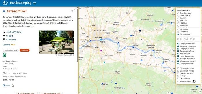
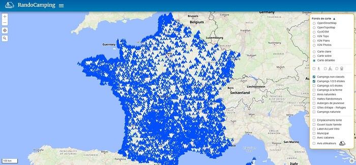
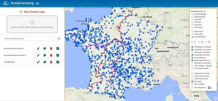
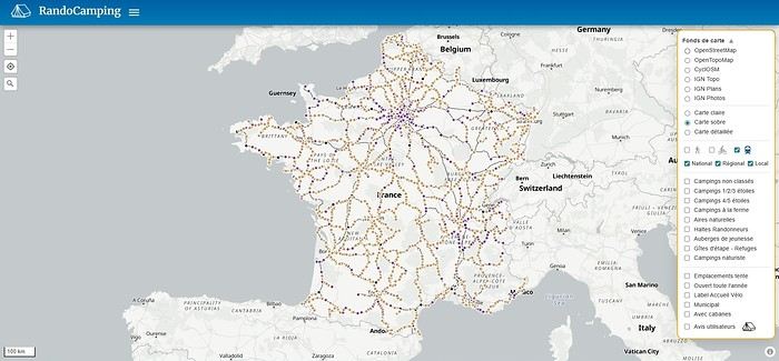
Its goal is to help trekkers find accommodations (usually by the night) all across France and to promote hosts who welcome trekkers satisfactorily.
Check it out here: https://randocamping.touteslatitudes.fr
The site is collaborative and supported by associations like Cyclo-Camping International or AF3V.
It lets you plan a trip or trek (on foot or by bike) by searching for accommodations along a route. The accommodations come from the DataTourisme platform (which aggregates information from Tourist Offices) and from users (trekkers & hosts).
Train lines and passenger stations are also listed. Clicking on a station can show you (if the data is available) how accessible the platforms are with a non-dismantled bike. Bike and hiking routes come from Waymarked Trails (which is based on OpenStreetMap).
You can find more details about the site’s features on this page (version 1.0): https://randovelo.touteslatitudes.fr/randocamping-v1/
Hi there,
Coming from Laos (*), I’m planning to enter Thailand by bike via the Fourth Thai–Lao Friendship Bridge.
Before this bridge was built, I’d already cycled the road from Louang Namtha to Houei Sai and crossed the river by boat to reach Thailand.
At the time, the condition of that road was impeccable, and most importantly, traffic was light.
So I’m wondering if anyone who’s taken it recently can tell me whether traffic has increased since the bridge opened.
Thanks in advance!
(*) I’m currently cycling in China (Yunnan)
Coming from Laos (*), I’m planning to enter Thailand by bike via the Fourth Thai–Lao Friendship Bridge.
Before this bridge was built, I’d already cycled the road from Louang Namtha to Houei Sai and crossed the river by boat to reach Thailand.
At the time, the condition of that road was impeccable, and most importantly, traffic was light.
So I’m wondering if anyone who’s taken it recently can tell me whether traffic has increased since the bridge opened.
Thanks in advance!
(*) I’m currently cycling in China (Yunnan)
Hi,
A friend is looking for a bike to embark on a long trip, but the issue is he’s only 1.55m tall.
In itself, that’s not a problem 😏, except that finding an XS-sized touring bike isn’t easy.
Some start at 1.55m, but it’s still a bit extreme.
If anyone knows of brands or models that might work...
Thanks in advance
Hello young cycling enthusiasts,
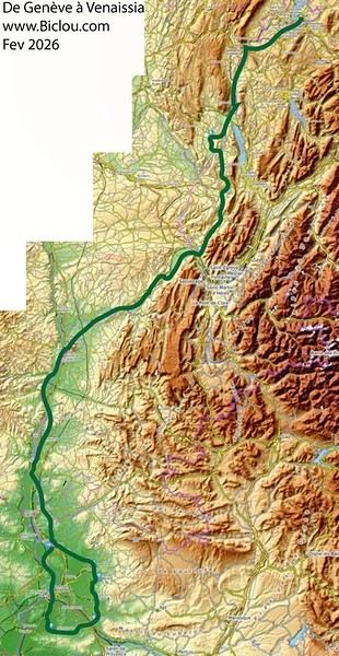
I’m starting a thread about the bike route known as venaissia.
Claudio took advantage of this February 2026’s mild weather to check out what it looks like.
Here we go—story and photos coming soon: http://cbandiera.free.fr/recits/2026-venaissia/
The plan was to go from Faverges to Cavaillon and explore the Via Venaissia a bit. A crazy idea? Maybe, but don’t forget that the month of February—"februare" in Latin—means "to purify," so it’s the Month of the Lupercalia, a Roman festival that was a purification rite. So, to purify himself after the feasts of the Saturnalia, Claudio set off (from an oak tree, no less) to pedal south.
He returned a little soaked but alive: The stages were as follows: (to be continued)
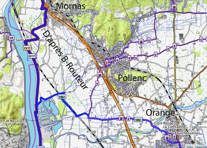
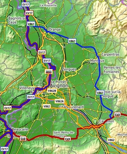 overall impression:
good signage, but Claudio still managed to get lost in cities like Orange and Carpentras...
Cavaillon... got lost several times, but thanks to the map and GPS, he got back on track...
Nice route, sometimes a bit boring, quiet, deserted (normal given the weather), threatening skies, but he escaped the rain.
overall impression:
good signage, but Claudio still managed to get lost in cities like Orange and Carpentras...
Cavaillon... got lost several times, but thanks to the map and GPS, he got back on track...
Nice route, sometimes a bit boring, quiet, deserted (normal given the weather), threatening skies, but he escaped the rain.
Claudio took advantage of this February 2026’s mild weather to check out what it looks like.
Here we go—story and photos coming soon: http://cbandiera.free.fr/recits/2026-venaissia/
The plan was to go from Faverges to Cavaillon and explore the Via Venaissia a bit. A crazy idea? Maybe, but don’t forget that the month of February—"februare" in Latin—means "to purify," so it’s the Month of the Lupercalia, a Roman festival that was a purification rite. So, to purify himself after the feasts of the Saturnalia, Claudio set off (from an oak tree, no less) to pedal south.
He returned a little soaked but alive: The stages were as follows: (to be continued)
overall impression:
good signage, but Claudio still managed to get lost in cities like Orange and Carpentras...
Cavaillon... got lost several times, but thanks to the map and GPS, he got back on track...
Nice route, sometimes a bit boring, quiet, deserted (normal given the weather), threatening skies, but he escaped the rain.Hello,
I’m 72 years old and I’m flying to Beijing from Rome on March 26th. My return is planned for May 11th from Ulaanbaatar to Frankfurt. I’m thinking of buying a cheap bike in Beijing and riding to Hohhot, stopping to see the Great Wall of China along the way. From Hohhot, I’ll take the train to cross the border and get off at Sainshand in Mongolia, then continue to Ulaanbaatar. Can anyone give me some tips? Thanks!
Gérald