Hi there,
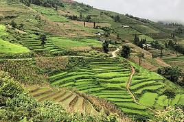
We’re spending a month in northern Vietnam this coming November and we’d love to do some day hikes around the village of Mu Cang Chai to see the famous spiral terraced rice fields. We’ll most likely be staying in Mu Cang Chai itself and we don’t have a car.
It’s really tough to find a route online. Any tips would be great.
Thanks in advance.
Hello, I’d like to embark on a little trip in my home country, Switzerland. I’ll start walking from La Cure, heading toward Le Noirmont first, then I’ll improvise my route—but it’ll probably follow the French border... at least as far as Lac de Joux.
I’ll decide day by day how much farther to go after that. My goal is to stay in nature as much as possible, wander around for as long as I can, and restock food in villages or towns along the way.
I’m thinking of mostly camping, but we’ll see if I end up in a hotel or another campsite depending on my route.
I’d love to reach La Chaux-de-Fonds on foot... maybe even Delémont. The whole thing should take about a week, give or take.
I’ll be bringing my dog, and I’m preparing for this as soon as I’m ready.
Any tips to make sure everything goes smoothly for us? Things I should know—or avoid? What about shepherds with their flocks of sheep? And isn’t hunting season open right now?
I’m not sure if what I’m planning is even doable, which is why I’m asking around.
This’ll be my first time doing something like this—wandering in nature *and* with a dog. I’m really excited for this adventure... and I need it. Thanks!
I’ll decide day by day how much farther to go after that. My goal is to stay in nature as much as possible, wander around for as long as I can, and restock food in villages or towns along the way.
I’m thinking of mostly camping, but we’ll see if I end up in a hotel or another campsite depending on my route.
I’d love to reach La Chaux-de-Fonds on foot... maybe even Delémont. The whole thing should take about a week, give or take.
I’ll be bringing my dog, and I’m preparing for this as soon as I’m ready.
Any tips to make sure everything goes smoothly for us? Things I should know—or avoid? What about shepherds with their flocks of sheep? And isn’t hunting season open right now?
I’m not sure if what I’m planning is even doable, which is why I’m asking around.
This’ll be my first time doing something like this—wandering in nature *and* with a dog. I’m really excited for this adventure... and I need it. Thanks!
Hi there,
I’m looking for organizations that specialize in walking safaris, but not at the price points I’m seeing online.
I’m after a truly immersive experience in the wild, with the option to sleep in very basic tents and help prepare meals...
Ideal duration: 7 to 10 days.
I’d rather avoid the super touristy destinations (Kenya, Tanzania, etc.).
Thanks for any tips you can share! !
Hi there, I’m planning to stay in Mae Hong Son for 4 days and Pai for 3 or 4 days to explore both towns and their surroundings. I’m not renting a car or scooter—I like to travel at a relaxed pace...
I’d love to know if it’s possible to do quite a few walks on foot from both towns and if it’s easy to find a tuk-tuk for the day to go a bit further.
I’ve heard that biking is really only for brave cyclists, which definitely isn’t me!
Thanks for your tips
I’d love to know if it’s possible to do quite a few walks on foot from both towns and if it’s easy to find a tuk-tuk for the day to go a bit further.
I’ve heard that biking is really only for brave cyclists, which definitely isn’t me!
Thanks for your tips
Hi,
Could recent travelers let me know the price for the 2D/1N trek in the rice terraces when booking directly on-site upon arrival? Is it possible to join a group? Thanks for your replies, best regards
Hello everyone, dear Globetrotters,
Just a quick message to ask what the roads and trails are like in Sikkim in July and August, please?
I’m quite familiar with India during the monsoon since I’ve already slogged through it (Kolkata and the Ganges plain), and I live in Réunion where I do trail running, so I’m not too worried about walking in the rain... but my question is more about access and feasibility.
Do you think it’s still possible to get around easily in Sikkim (not too many roads closed) and have a chance of occasional clear views?
Ideally, I’d love to explore the north and west of Sikkim with views of Kanchenjunga. It’s not a big deal if I have to wait for moments when it clears—I’ll have time.
What do you think?
If you’ve got good reasons to check out the east of Sikkim, I’m all ears... ;-)
Have a great day, everyone, and thanks in advance,
Nico
Just a quick message to ask what the roads and trails are like in Sikkim in July and August, please?
I’m quite familiar with India during the monsoon since I’ve already slogged through it (Kolkata and the Ganges plain), and I live in Réunion where I do trail running, so I’m not too worried about walking in the rain... but my question is more about access and feasibility.
Do you think it’s still possible to get around easily in Sikkim (not too many roads closed) and have a chance of occasional clear views?
Ideally, I’d love to explore the north and west of Sikkim with views of Kanchenjunga. It’s not a big deal if I have to wait for moments when it clears—I’ll have time.
What do you think?
If you’ve got good reasons to check out the east of Sikkim, I’m all ears... ;-)
Have a great day, everyone, and thanks in advance,
Nico
Hi,
We’re planning to spend 3 nights (4 days) in the Banaue area. We’ve booked 1 night in Banaue, 1 in Batad, and the 3rd back in Banaue. We’d like to get from one village to the other on our own (tricycle + hiking). Does that sound doable? Where can we find a hiking route so we don’t get lost (is Maps.me enough?)? The 2-day trek offered by guides is a bit tough and, above all, too expensive for us (83 €/person). Thanks for your feedback and experiences!
Hi there, my friend and I are planning a winter getaway to Morocco, with a flight from Paris to Marrakech, and we’d love some suggestions for itineraries (we’re thinking of renting a car to get around more easily).
We’re really into nature, meeting locals, staying with families, and hiking+++. Given the season, we’ll obviously avoid the Atlas and high-altitude hikes. But are there any other day-hike options in regions with milder winter weather? For example, in the Anti-Atlas?
We’re really into nature, meeting locals, staying with families, and hiking+++. Given the season, we’ll obviously avoid the Atlas and high-altitude hikes. But are there any other day-hike options in regions with milder winter weather? For example, in the Anti-Atlas?
Hi everyone,
I’m finalizing my trip plans for Sumatra in June. I’m trying to lock in a trek (around 5 days), but I’m not really finding what I’m looking for.
The idea is to really go "off the beaten path" (I’m not a fan of the phrase since it’s lost all meaning, but anyway...). However, I’m struggling to find destinations or programs that are even slightly original.
We’re leaning toward a jungle trek starting from Ketambe—it seems nice in itself, but it feels a bit repetitive. All the guides offer the same packages: stops at fixed camps, you settle in, walk around the camp, eat, sleep, then move on the next day for 2-3 hours with the same routine. After all my research, I feel like I’ve already seen it all because every guide and tourist posts the same photos (hollow tree, hot springs, etc.).
Anyway, do you know of a guide or agency that offers a *real* trek (meaning you walk all day until you find a spot for the night, from a starting point A to an endpoint B) in an area that’s a little different from where everyone else goes? (Gunung Leuser or similar, though for transport and time reasons, I’d ideally like to stay in northern Sumatra.)
Thanks, and if you have any good tips about anything related to Sumatra, I’m all ears.
Have a great day,
I’m finalizing my trip plans for Sumatra in June. I’m trying to lock in a trek (around 5 days), but I’m not really finding what I’m looking for.
The idea is to really go "off the beaten path" (I’m not a fan of the phrase since it’s lost all meaning, but anyway...). However, I’m struggling to find destinations or programs that are even slightly original.
We’re leaning toward a jungle trek starting from Ketambe—it seems nice in itself, but it feels a bit repetitive. All the guides offer the same packages: stops at fixed camps, you settle in, walk around the camp, eat, sleep, then move on the next day for 2-3 hours with the same routine. After all my research, I feel like I’ve already seen it all because every guide and tourist posts the same photos (hollow tree, hot springs, etc.).
Anyway, do you know of a guide or agency that offers a *real* trek (meaning you walk all day until you find a spot for the night, from a starting point A to an endpoint B) in an area that’s a little different from where everyone else goes? (Gunung Leuser or similar, though for transport and time reasons, I’d ideally like to stay in northern Sumatra.)
Thanks, and if you have any good tips about anything related to Sumatra, I’m all ears.
Have a great day,
Hello,
I’d like to know what small gifts I could bring for women, children, and men in the Surma tribes of the western Omo Valley.
Usually, I bring pencils, pens, perfumes, and cigarettes, depending on the country.
What do you recommend?
Philippe Departure on 11/13/24
What do you recommend?
Philippe Departure on 11/13/24
Hi,
I'd love to know where we can observe wildlife, birds, and nature in Colombia... Like going on a hike without a guide, immersing ourselves in the forest, far from tourist spots. I want to avoid places that are specially set up, since you usually don’t see much there.
Thanks in advance!
Bernard
Hi there, I’m planning the Annapurna Circuit for March 2027 and I’m looking for a local agency with a local guide—preferably French-speaking—to arrange this trek for us. Any suggestions? Thanks
Hi there,
We’re planning to hike the GRR2 this summer with a local agency that offers a self-guided south-to-north route. We’re active and hike regularly, but we’ve never done a trek just the two of us without a guide.
I’d love to know if this trail has any dangerous areas? Drop-offs? Are there spots where it’s easy to lose the path?
I’ve seen that some agencies offer a GPS app—does the signal even reach everywhere inland? 🤪
Thanks! 😄
Looking forward to hearing from you! !
We’re planning to hike the GRR2 this summer with a local agency that offers a self-guided south-to-north route. We’re active and hike regularly, but we’ve never done a trek just the two of us without a guide.
I’d love to know if this trail has any dangerous areas? Drop-offs? Are there spots where it’s easy to lose the path?
I’ve seen that some agencies offer a GPS app—does the signal even reach everywhere inland? 🤪
Thanks! 😄
Looking forward to hearing from you! !
Hi there,
I’d like to visit several islands in the Cyclades in late June - early July 2026 for about 15 days.
Stay 3 to 4 days on each one and do some hiking.
Your suggestions are welcome—islands, accommodation, hikes, or anything else.
Thanks in advance.
Twizzle
A message in a bottle:
For a three-week trip in November... is it possible to go hiking without a guide in northern Vietnam, getting around to the hiking sites by public transport, bikes, or on foot? And if so, which areas specifically?
Thanks to anyone who replies!8
Hi there,
I’m planning a trip to Rwanda with a focus on hiking and using local transport.
Could anyone share or confirm the entrance fees for the national parks?
- Volcanoes National Park: Is it possible to visit without the $1,500 gorilla trek?
- Nyungwe Forest National Park
- Akagera National Park: $100 per person per day + $40 for a car
Is there an entrance fee for the Congo Nile Trail? If anyone has great tips or recommendations for this trail and other hikes in the country, I’d love to hear them. Thanks so much!
Is there an entrance fee for the Congo Nile Trail? If anyone has great tips or recommendations for this trail and other hikes in the country, I’d love to hear them. Thanks so much!
Hi there, we’re planning to do the Valley of Roses trek without a guide. Which village should we start the trek from? Is the route easy to find? Will 3 to 4 days be enough? (We’re experienced hikers and good walkers.) Which stopover villages would you recommend?.....Thanks! FG
Hi there,
I’d like to get some info about the GR10 Pyrenees traverse. I need help planning the daily stages and accommodations—my wife isn’t an experienced hiker but walks a lot, so I’d like to schedule shorter walking days and thus a longer overall trip in terms of number of days.
Could anyone give me some help and advice? Best regards,
I’d like to get some info about the GR10 Pyrenees traverse. I need help planning the daily stages and accommodations—my wife isn’t an experienced hiker but walks a lot, so I’d like to schedule shorter walking days and thus a longer overall trip in terms of number of days.
Could anyone give me some help and advice? Best regards,
I want to do sections of the Collioure-Cadaqués trail. I plan to stay in Collioure first to hike the paths on the French side using the bus. Speaking of which, I’m wondering if it’ll be easy to find a seat on the buses at the end of April, beginning of May.
After that, I’ll head to Figueres to do sections of the trail on the Spanish side. I’m worried the buses might not be too crowded at the end of April.
Here’s what I’m interested in: Llanca - Port de la Selva: Figueres - Llanca by train in the morning and Port de la Selva - Figueres on the way back Port de la Selva - Cadaqués: Figueres - Port de la Selva in the morning and Cadaqués - Figueres on the return trip
I’d also like to go to Cadaqués from Figueres as a day trip. I’m concerned about how busy this route might be at the end of April.
I’m wondering if I need to get tickets in advance and where to buy them.
After that, I’ll head to Figueres to do sections of the trail on the Spanish side. I’m worried the buses might not be too crowded at the end of April.
Here’s what I’m interested in: Llanca - Port de la Selva: Figueres - Llanca by train in the morning and Port de la Selva - Figueres on the way back Port de la Selva - Cadaqués: Figueres - Port de la Selva in the morning and Cadaqués - Figueres on the return trip
I’d also like to go to Cadaqués from Figueres as a day trip. I’m concerned about how busy this route might be at the end of April.
I’m wondering if I need to get tickets in advance and where to buy them.
Hi everyone,
Here’s my dilemma:
I’m planning a hike between Le Bonhomme and the Gîte des 3 Fours at the Col de la Schlucht.
Between the two, I need a hostel, a gîte, or a farm inn for Wednesday, September 10th.
My gîte at the pass is only open on Thursday, so I need a stop between Le Bonhomme and the pass.
On Wednesday, everything’s closed—no half-board, nothing at all.
Would you have any solutions? I’ve already called the tourist office, and they confirmed there’s no possibility.
No tent—it’s too heavy for me at my age.
Thanks for your ideas!
Hi,
We’re planning to do the 4-day trek from Mestia to Ushguli without an agency. The descriptions mention that there are accommodations at each stop, but we can’t find any details about them. Has anyone got info or feedback on this route?
Thanks
Cat, Bruno.
Thanks
Cat, Bruno.
Hi there,
I’m planning to do the Mercantour crossing following the Randoxygène route in mid-July. I’m used to hiking in the mountains, but I sometimes get vertigo, for example on ridges with drops on both sides. I wanted to check if there are any T4 or T3-T4 sections and find out if there are any very exposed passages—and if so, where—so I can plan an alternative route. Can anyone give me some info on this? Thanks!
I’m planning to do the Mercantour crossing following the Randoxygène route in mid-July. I’m used to hiking in the mountains, but I sometimes get vertigo, for example on ridges with drops on both sides. I wanted to check if there are any T4 or T3-T4 sections and find out if there are any very exposed passages—and if so, where—so I can plan an alternative route. Can anyone give me some info on this? Thanks!
Hi there,
This August, I hiked the Vosges section (Vosges massif) of the GR5 (Lauterbourg-Wissembourg-gr53-gr5-Belfort) using the TopoGuide "Traversée du Massif des Vosges" (ref 502, April 2024 edition). My experience was partly ruined by a few things I feel I should share here to help others avoid the same pitfalls—or at least disappointments.
Having used "TopoGuide" books before, I’d always trusted them for organizing treks lasting several weeks, or even months.
Beyond the satisfactory mapping (reproductions of IGN 1:25,000 maps), these guides include route descriptions that are usually enough to find your way. On that point, I have no serious criticism of the Vosges crossing guide.
In addition to the route details, the guide provides "average" time estimates for traveling from point A to point B—useful info for gauging effort and planning likely stages. However, I eventually realized I couldn’t rely on these time estimates. I’d assumed they were calculated by the FFRP, considering that 100m of positive elevation gain roughly equals 1km on flat terrain, with an average walking speed of 4km/h. So, I’d recommend anyone using this guide to recalculate all the time estimates to avoid nasty surprises on tight stages. 🤪
Another key feature of the guide, in my opinion, is its info on accommodation options—especially budget-friendly ones suited for long-distance hikers on a tight budget. A section called "préparation des étapes" includes a table with a column meant to highlight "refuges" and "gîtes d'étapes." That column had me feeling optimistic: these budget accommodations were listed as plentiful along the route. After all, we were in the territory of the famous Club Vosgien—it made sense there’d be plenty of hiker-friendly lodging options. The reality on the ground was quite different. The TopoGuide wasn’t really to blame here, except that a serious warning wouldn’t have hurt. First, regarding the "refuges," most were run by associations. With rare exceptions, the volunteers only opened them on weekends. You can’t really blame people for not volunteering on weekdays, but it makes things tricky when the info about weekend-only openings often turns out to be wrong. As for the "gîtes d'étape," I was mostly disappointed when I was told that a place was booked for weeks: the vast majority of what was listed as a "gîte d'étape" turned out to be "gîtes ruraux." The advice here? If you don’t want to—or can’t—camp, double-check all the accommodation details before you set off. It’s time-consuming and tedious, but if you can, camping is still the best option. 😐 On a brighter note, during the first part of my trip, I came across several cabins that offered alternatives to camping. 🙂
P.S.: Even the youth hostel in Saverne was closed in the middle of August... 😕
Having used "TopoGuide" books before, I’d always trusted them for organizing treks lasting several weeks, or even months.
Beyond the satisfactory mapping (reproductions of IGN 1:25,000 maps), these guides include route descriptions that are usually enough to find your way. On that point, I have no serious criticism of the Vosges crossing guide.
In addition to the route details, the guide provides "average" time estimates for traveling from point A to point B—useful info for gauging effort and planning likely stages. However, I eventually realized I couldn’t rely on these time estimates. I’d assumed they were calculated by the FFRP, considering that 100m of positive elevation gain roughly equals 1km on flat terrain, with an average walking speed of 4km/h. So, I’d recommend anyone using this guide to recalculate all the time estimates to avoid nasty surprises on tight stages. 🤪
Another key feature of the guide, in my opinion, is its info on accommodation options—especially budget-friendly ones suited for long-distance hikers on a tight budget. A section called "préparation des étapes" includes a table with a column meant to highlight "refuges" and "gîtes d'étapes." That column had me feeling optimistic: these budget accommodations were listed as plentiful along the route. After all, we were in the territory of the famous Club Vosgien—it made sense there’d be plenty of hiker-friendly lodging options. The reality on the ground was quite different. The TopoGuide wasn’t really to blame here, except that a serious warning wouldn’t have hurt. First, regarding the "refuges," most were run by associations. With rare exceptions, the volunteers only opened them on weekends. You can’t really blame people for not volunteering on weekdays, but it makes things tricky when the info about weekend-only openings often turns out to be wrong. As for the "gîtes d'étape," I was mostly disappointed when I was told that a place was booked for weeks: the vast majority of what was listed as a "gîte d'étape" turned out to be "gîtes ruraux." The advice here? If you don’t want to—or can’t—camp, double-check all the accommodation details before you set off. It’s time-consuming and tedious, but if you can, camping is still the best option. 😐 On a brighter note, during the first part of my trip, I came across several cabins that offered alternatives to camping. 🙂
P.S.: Even the youth hostel in Saverne was closed in the middle of August... 😕
Hi there,
I’m planning a short trek on the Haute Route des Pyrénées from Embalse de Baserca lake to Parzan.
I’ve seen there are cabins along the route. Do you know if it’s possible to sleep in them? On the other hand, in Parzan, apart from a hotel, I can’t find anything else. And the hotel requires a minimum of 2 nights, whereas I only want to stay for one. So, do you know where to stay in Parzan?
I’ve seen there are cabins along the route. Do you know if it’s possible to sleep in them? On the other hand, in Parzan, apart from a hotel, I can’t find anything else. And the hotel requires a minimum of 2 nights, whereas I only want to stay for one. So, do you know where to stay in Parzan?
Hi there,
This summer, my sister and I would like to do part of the tour of old Chaillol. We’re thinking of leaving our car at Chapelle en Valgaudemar and going hiking for three days with two nights in a mountain refuge. At the end of the third day, do you know if it’s possible to take a bus or coach to get back to Chapelle en Valgaudemar? From Pont du Fossé or Chabottes. If not, would you have another more suitable route to suggest?
Thanks in advance.
This summer, my sister and I would like to do part of the tour of old Chaillol. We’re thinking of leaving our car at Chapelle en Valgaudemar and going hiking for three days with two nights in a mountain refuge. At the end of the third day, do you know if it’s possible to take a bus or coach to get back to Chapelle en Valgaudemar? From Pont du Fossé or Chabottes. If not, would you have another more suitable route to suggest?
Thanks in advance.
Hi there,
I go on mountain hikes lasting about ten days with a backpack that doesn’t exceed 11 kg. I’d like to switch to a different category of shoes now. Up until now, I’ve been using semi-rigid leather mid-height models, but I’ve had major after-sales service issues with them. They’ve been sent back for repairs three times—5 months, then 6 months of waiting—because the toe cap came unstuck. It just doesn’t hold up.
I’m thinking of switching to mid-height or even low-cut models. But I’m wondering if this change comes with any risks. Also, which category would be best suited: trail shoes, approach shoes, or mid-height? Thanks in advance for your insights!
I go on mountain hikes lasting about ten days with a backpack that doesn’t exceed 11 kg. I’d like to switch to a different category of shoes now. Up until now, I’ve been using semi-rigid leather mid-height models, but I’ve had major after-sales service issues with them. They’ve been sent back for repairs three times—5 months, then 6 months of waiting—because the toe cap came unstuck. It just doesn’t hold up.
I’m thinking of switching to mid-height or even low-cut models. But I’m wondering if this change comes with any risks. Also, which category would be best suited: trail shoes, approach shoes, or mid-height? Thanks in advance for your insights!
Hi,
I’d like some advice on doing the Camino de Santiago—or part of it—from the Basque Country.
Best,
Hi there, we're looking for **self-sufficient hikes** (day trips and multi-day treks), mainly in **Northern Vietnam**, and possibly a bit in the central region.
+If you’ve got any in **Thailand** not too far from Bangkok or in **Cambodia** not too far from the country, that’d be great too!
We’d really appreciate your tips!
Thanks! 🙂
+If you’ve got any in **Thailand** not too far from Bangkok or in **Cambodia** not too far from the country, that’d be great too!
We’d really appreciate your tips!
Thanks! 🙂
Hi there,
I’d love some tips for visiting the Chocó region near the Pacific in Colombia. I’m assuming I’ll fly in... Where should I stay? Where can I walk in the forest (without a guide)? Where can I see wildlife, go diving, hiking, and what are the best places to stay? Also, how do I get around, etc.?
Thanks in advance!
Bernard
Hello,
We’re really keen on ecosystems and want to hike in "natural" ancient forests—not planted woods or areas heavily degraded by human activity. Travel guides (like Lonely Planet) don’t provide much info on this. Could you point us to the most interesting spots? Thanks in advance for your tips. We wish you happy holidays and a fantastic 2026, full of discoveries! Claire and Albert
We’re really keen on ecosystems and want to hike in "natural" ancient forests—not planted woods or areas heavily degraded by human activity. Travel guides (like Lonely Planet) don’t provide much info on this. Could you point us to the most interesting spots? Thanks in advance for your tips. We wish you happy holidays and a fantastic 2026, full of discoveries! Claire and Albert