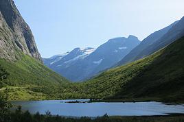
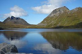
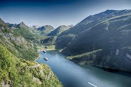
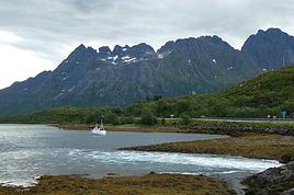
Donc voilà avec un pote c'est partie pour 3semaines de rando aux Lofoten
Total autonomie , donc pas de refuge ou autre
Sauf que voilà je stresse à un jour du départ alors que j'étais serein jusqu'à la .
Je doute de tout ... peur d'avoir froid , faim, la météo etc je remet tout en cause alors que pourtant j'ai hâte d'y être mais d'un autre ça me fait un peu peur ,
Si des personnes pouvaient me rassurer un peu en me racontant leurs parcours galère , bon moment etc ça serait cool
Ma plus grosse angoisse , le froid et la pluie
Au passage mon sac fait 17kg ça le semble énorme j'ai pourtant prisnle stricl minimum (la nourriture pèse rien qu'à elle 3kg ) faute de moyen pour le lyophilisé
Salut !
Pas de soucis, les randos aux Lofoten s'est très peu engagé. ça me fait sourire d'entendre "3 semaines d'autonomie", mais non, tu sera obligé de traverser une route ou un village tout les 2-3 jours. Tu n'es jamais loin de tout. Ceçi dit, c'est magnifique, sublime, incroyable, n'interprète pas mal mon propos : je dis juste que ce n'est pas engagé, et qu'on part pas aux Lofoten pour une semaine de trek en autonomie ! Ce n'est pas l'Hargandarvidda par exemple. Vraiment pas d'inquiétude à te faire. Par contre pour la météo, c'est clair qu'il peut pleuvoir 3 semaines… on n'a eu 1 seul jour sans précipitation sur 17 en avril aux Lyngen… faut donc bien être équipé contre la pluie, ça c'est sûr… et avoir assez de place pour lire/cuisiner etc. dans la tente… mais tu il y a aussi des grandes périodes de beaux ! 12 jours sur 14 de grand ciel bleu la dernière fois que j'y suis allé.
Pour des topos de treks et des informations précises sur les pays que j'ai visités, rendez-vous sur mon blog : https://treketvoyages.com/.
Il fonctionne comme un modeste guide de voyage et non comme un récit de voyage.
3 semaines cela me parait beaucoup pour les Lofoten qui sont assez petites. Tu peux aussi aller sur la rando de Kungsleden, en Suede, mais pas loin des Lofoten.
C'est normal d'angoisser avant le départ, on connaît tous ça. Tu es jeune, si tu es un peu entraîné et que tu as un gabarit classique, 17 kg ne sont pas un problème. Il y a de quoi se ravitailler sur place, comme l'ont dit les contributeurs précédents, les Lofoten, ce n'est pas très engagé.
Après, ça dépend de ce que vous faites : avec de l'itinérant tous les jours, avec les dénivelés, ça va être un peu fatigant mais vous pourrez aussi alterner avec des sommets en laissant la plus grande partie de votre matériel à un camp de base. Vous vous adapterez en fonction des circonstances.
Si tu es bien équipé, tu n'auras absolument pas froid et la pluie sera juste un peu ennuyante. Je suis allée deux fois en Norvège : temps mêlé avec pas mal de soleil et jusqu'à 30 °C la première année, treize jours d'autonomie avec 21/22 kg et un sac pas très adapté au départ - j'en ai bavé au début - et temps pourri avec pluie, brouillard et neige la deuxième année, neuf jours d'autonomie et 18/19 kg avec un meilleur sac, je me suis éclatée dans le premier voyage et j'ai carrément craqué sur la région et les gens visités avec le deuxième.
C'est beau, les gens sont sympas avec les randonneurs, vous pourrez modifier votre programme en fonction de vos envies, vous allez vous éclater.😉
Je suis d'accord avec Pierre, 3 semaines aux Lofoten c'est beaucoup... pourquoi ne pas aller ensuite sur l'île de Senja ou aux Alpes Lyngen (et là c'est plus autonomie).
Pour des topos de treks et des informations précises sur les pays que j'ai visités, rendez-vous sur mon blog : https://treketvoyages.com/.
Il fonctionne comme un modeste guide de voyage et non comme un récit de voyage.
C'est normal d'avoir peur .... voyager c'est toujours partir dans l'inconnu, prendre quelques risques et se lancer, c'est ça qui est fabuleux 😉. Mais en partant dans les îles Lofoten, les risques sont trèèèèèès minces. C'est finalement assez petit et tu n'es jamais bien loin d'un village, d'un magasin, d'un bon petit resto, voire d'un hytter confortable si tu trouves que la météo est vraiment trop rude.
A propos de la météo, il faudrait vraiment une malchance extraordinaire pour qu'il pleuve continuellement pendant trois semaines d'affilée ;-) Par contre, s'il pleut de temps à autre, ça donne aussi son charme à certains paysages. Mes plus belles photos des Lofoten (enfin c'est mon avis), je les ai prises le dernier jour de notre voyage, quand il y avait un petit peu de brume qui flottait autour des montagnes. C'était magnifique. Et quand il fait beau, c'est magnifique aussi 😉.
Bon voyage ! Une fois sur place, tu oublieras tes craintes.
Nous devrions ma femme et moi aller dans les îles Lofoten début avril jusqu'à mi-avril. Pensez vous qu'il est possible de se faire quelques randonnées sans…
Nous sommes une famille de 5 avec 3 enfants d’une dizaine d’annees. Nous projetions d’aller sur les îles Lofoten en Avril 2020. Comme vous y êtes partis quel…
Je part 13 jours en Norvège avec ma copine, aux îles Lofoten pour une randonnée en autonomie complète (traversée du nord au sud, de Slolvaer à Moskenes).…
Je suis nouveau sur ce forum et je vais peut-être reposé les mêmes questions que d'autres mais je ne trouves pas les réponses à mes questions, je m'excuse par…
J'ai eu un peu de mal à trouver les bonnes infos avant de partir randonner aux Lofoten, donc voici quelques éléments, qui j'espère seront utiles et vous…
Bonjour,
Nous souhaitons faire le trek de 4 jours reliant Mestia à Ushguli sans agence. Il est précisé dans les descriptifs qu'il existe des hébergement à chaque étape, mais on ne trouve pas d'info sur ces hébergements. Quelqu'un a-t-il des infos et un avis sur ce parcours?
We're planning to trek in Peru and Bolivia and would love to find some local agencies.
If you know any, could you share details on prices and, of course, the names of the agencies?
Which trek would you recommend?
Elocine
Je pars en autonomie totale sur un trek au Maroc (10jrs) Imilchil - Aghbalou.
Trouve t-on des cartouches gaz à vis (Coleman, Primus) à Marrakech (adresse) ou villages entre Imilchil - Aghbalou ?
Si non , trouve-t-on des cartouches Butagaz pour camping-gaz (petit volume 230 gr ...)
Merci d' avance pour vos réponses
Hello, I’d like to embark on a little trip in my home country, Switzerland. I’ll start walking from La Cure, heading toward Le Noirmont first, then I’ll improvise my route—but it’ll probably follow the French border... at least as far as Lac de Joux.
I’ll decide day by day how much farther to go after that. My goal is to stay in nature as much as possible, wander around for as long as I can, and restock food in villages or towns along the way.
I’m thinking of mostly camping, but we’ll see if I end up in a hotel or another campsite depending on my route.
I’d love to reach La Chaux-de-Fonds on foot... maybe even Delémont.
The whole thing should take about a week, give or take.
I’ll be bringing my dog, and I’m preparing for this as soon as I’m ready.
Any tips to make sure everything goes smoothly for us? Things I should know—or avoid? What about shepherds with their flocks of sheep? And isn’t hunting season open right now?
I’m not sure if what I’m planning is even doable, which is why I’m asking around.
This’ll be my first time doing something like this—wandering in nature *and* with a dog. I’m really excited for this adventure... and I need it. Thanks!
We’re really keen on ecosystems and want to hike in "natural" ancient forests—not planted woods or areas heavily degraded by human activity. Travel guides (like Lonely Planet) don’t provide much info on this. Could you point us to the most interesting spots?
Thanks in advance for your tips.
We wish you happy holidays and a fantastic 2026, full of discoveries!
Claire and Albert
Hi, this might not be the right section, but I’d like to know if it’s possible to start mountaineering with another person without necessarily hiring a guide. We’ve done quite a bit of hiking but not mountaineering—we’ll just do a half-day glacier course. After that, we were thinking of starting with La Grande Motte and the Pointe de la Traversière, which were recommended to us. Honestly, for things like roping up and knots, I’ll learn at home with lots of videos and a book.
Hi,
I don’t know Switzerland at all and was wondering if Vallée des Joux and especially Dent de Vaulion are packed early in the morning or late in the afternoon in July and September?
If so, do you have any quieter spots to recommend in the area, or in Luxembourg (yes, I know it’s not the same country 😉)?
Thanks a lot!
Jaimerais savoir si quelqu'un aurait fait des treks sur le Ruwenzori et combien ça coute en moyenne, les infrastructures, les paysages la sécurité sur les lieux, merci beaucoup. J'attends avec impatience vos réponses.
We’re leaving in 9 days for a two-week trip to Madeira, mainly to hike.
From my research, I’ve found that since last year, access to most trails—and systematically for the most popular ones—is now paid. You have to pay an access fee of 4.50 € per person per classified hike in 2026, and even 10.50 € for the most iconic hike: Pico Arieiro to Pico Ruivo. When paying, you also have to choose a day and a 30-minute time slot for your start time. Of course, this reservation is neither changeable nor refundable, even if the weather that day is terrible.
Personally, given the massive influx of tourists to the island in recent years, I don’t mind paying a fee to help maintain the trails. Similarly, setting a limit on the number of people who can hike them per day is certainly preferable to preserve this priceless heritage.
However, what’s much less fair is that in reality, most of the available spots are reserved: 1/ for Madeira residents (which is normal); 2/ for "economic operators" (meaning local tour operators). For example, if you’re a non-resident (independent tourist), no booking is possible for the Pico Arieiro hike for an early morning start before September! So, unfortunately, we’ll have to skip this hike.
It’s the same issue for Ponta de São Lourenço, the 25 Fontes, Pico Ruivo... in short, all the most popular hikes. Oh well, we’ll skip those too!
So my question is: which hikes do you recommend where we won’t face the huge crowds that the others get? And where we can book the day before for the next day, taking the weather into account?
Finally, a quick accommodation question: we’ve booked the first week in Funchal, but I haven’t decided yet for the second week. Do you have any advice on where to stay in the south or north, preferably avoiding overly concrete-heavy and touristy spots?
I’m reposting about the logistics for Samaria Gorge.
I’d love to get recent info, especially about whether it’s possible to park my car in Omalos, do the hike, and then catch a bus back to my vehicle.
In theory, it’s doable, but when you check the KTEL website, there aren’t any feasible schedules listed. If anyone has recently organized this with reliable, verified details, I’d really appreciate it. Thanks in advance!
Hi there,
We’re flying from Montreal to Lyon this August to go hiking in the French Alps. We’ve rented a car and will be staying at campgrounds. We’re planning to do day hikes and want to stay a few days in one spot, do a few hikes, then move on to our next camping spot. Could you share your favorite spots or any recommendations for places to spend a few days with great hikes?
A few details:
We arrive in early August and leave in early September.
We’re looking for day hikes (or shorter), moderate difficulty, with a cumulative elevation gain of no more than 1000m, and of course, beautiful scenery!
We’d prefer not to drive too much—maybe it’s best not to head too far south and deal with unnecessary heat?
Along the same lines, if you know of any great campgrounds where we can start our hike directly without needing the car, we’d love to hear your suggestions!
Bonjour
Souhaitant faire de la randonnée sur cette île, je voudrais d'abord savoir quelle serait la période la plus favorable sachant que j'avais passé quelques jours en novembre 2018 pas pour cette activité mais plus pour une simple découverte de l'île et le temps n'était pas top notamment en montagne. Donc peut on choisir une organisation en étoile sachant que je louerai un véhicule avec éventuellement 2 points d'hébergement.
Je n'envisage pas d'intégrer une structure mais de partir à 2 et de s'organiser sauf si vous me conseillez une agence locale ou un guide local. Enfin même si je compte me procurer les différents supports, carte et topo guide plus gps je vous remercie de bien vouloir me communiquer les randos à faire en priorité
Merci beaucoup pour vos informations
I’m planning to do the Mercantour crossing following the Randoxygène route in mid-July.
I’m used to hiking in the mountains, but I sometimes get vertigo, for example on ridges with drops on both sides. I wanted to check if there are any T4 or T3-T4 sections and find out if there are any very exposed passages—and if so, where—so I can plan an alternative route.
Can anyone give me some info on this?
Thanks!
I’m planning a trip around Cap Corse and the AGRIATES in 2026, from May 8th to 15th (there are still 2 spots left, by the way! Just DM me if you're interested).
I’d love to know which hikes are worth prioritizing in the AGRIATES. We’ll be staying in SALECCIA for two days as our base—what should we focus on from there?
A round trip to IGNHU beach? Any other suggestions?
For Ostricano, I think it’s too far for a round trip...
Thanks for your tips!
Have a great day,
Anie, Toulouse
I’d like to get some info about the GR10 Pyrenees traverse. I need help planning the daily stages and accommodations—my wife isn’t an experienced hiker but walks a lot, so I’d like to schedule shorter walking days and thus a longer overall trip in terms of number of days.
Could anyone give me some help and advice?
Best regards,
New to this forum, I’m planning a pretty big project for 2028.
I’m heading to Nepal to do a trek from Kathmandu all the way to Everest Base Camp (a cool 5,300 m 😄).
This trek is a bit special because even though I’ll be part of a group, I’m going solo (so far, no problem—I’m used to it). But it’s my first real trek, and it’s also a humanitarian one: once I reach base camp, I’ll stay an extra week to help clean up the waste left by tens of thousands of climbers! Since I’m originally from South America, from two countries that share the Andes, I have a deep respect for mountains—they fascinate me. So Everest… it’s kind of the trip of a lifetime!
So, a little question for those who’ve done treks to Everest before… any tips for good mental preparation (I’m already working on the physical side)?
Hi there, I’m planning the Annapurna Circuit for March 2027 and I’m looking for a local agency with a local guide—preferably French-speaking—to arrange this trek for us. Any suggestions? Thanks
Hello!
We’re spending a few days in Toraja country at the end of May. We’d love to do a day trek—taking our time—on a route that’s stunning in terms of scenery, but not a level 5 in difficulty!
Any suggestions you can share, please?
Thanks in advance
I’d like to do the Mare a Mare Sud in May over 4 days. I’ve found quite a few places to stay along the route, but I’m stuck on the start and finish.
I’ll be arriving by plane on Sunday evening and would like to start pretty early on Monday morning. Ideally, accommodation right at the trailhead (Alzu di Gallina) would be amazing, but I can’t find anything. Any tips?
Also, for the transfer from Figari Airport to Porto Vecchio or Alzu di Gallina?
At the end, I’d like to pick up a rental car—any advice on that too?
I’m traveling solo by plane to Catania in May and plan to hike the northern side of Etna, starting from Linguaglossa where I’ll arrive by bus. After that, I’d love some info on how to get up to Piano Provenzana (shuttles or hitchhiking), since it seems there’s no public transport except in the summer. Can you sleep there in a free or cheap refuge, or camp? And how far up can you go without having to hire a guide? Thanks in advance. Bernard.
Bonjour a tous,
je pars en voyage au Maroc en aout et nous allons commencer par nous arrêter a Chefchaouen(nous sommes en voiture).
Ma question: quelqu'un peut il m'indiquer un itinéraire de rando en boucle d'entre 5 et 7 jours aux départ de Chefchaouen dans le parc de Talassemtane passant si possible par le pont de dieux?Ou un guide papier qui en reunis quelques uns?
Nous privilégions le camping sauvage et les gites.
Merci d'avance
Hi there, for those who’ve been recently—is it possible to find other solo travelers in March on the island to share transport or room costs? It doesn’t seem easy to travel on a budget.
If you have any recommendations for simple lodgings or places with dorms, I’d love to hear them.
For those who’ve done multi-day treks while moving around: do you need to bring your own sleeping bag? I’d love to hear about itineraries you’ve done without a guide, just with a map and GPS.
Thanks, and have a great day!
Hi everyone!
We’re planning a 15-day road trip to Scotland this summer, specifically to explore and hike on Lewis and Harris—places we’ve never been before. We’ve visited other islands on previous road trips in Scotland (we usually go in April for a week). This would be our first time in Scotland in the summer and for 15 days. We’re looking at late August to early September.
I’m currently drafting the itinerary. We’d be crossing from Ullapool and were thinking of spending 3 nights on Harris and 4 nights on Lewis.
Does that sound balanced to you? Is it better to keep the same accommodation on Harris and the same on Lewis to explore the area? I’d love to hear about any past experiences you’ve had on these islands.
Thanks!
Hi there, I’m trying to leave for 15 days very soon to São Vicente. I’m either looking to join an agency or figure things out on my own to go hiking on one of these islands or both. From what I’ve seen, it’s not easy to organize with local transport, so it gets expensive. Can I use the services of a small local agency? I’m looking for the simplest way to hike for several days. Also, how do you get from São Vicente to São Nicolau? Thanks in advance and have a great day!
Aichatou
I’ve been wanting to do this for several years, and this year’s the one. Next September, I’ll be trekking in Tusheti (Georgia), from Omalo to Shatili.
Of course, I won’t be renting a vehicle that’d just sit unused. No problem getting to Pshaveli, but from there to Omalo, it’s a dirt road (still the case?)
There must be some form of public transport since there are so many guesthouses, and not all travelers come in a 4x4.
If any of you have been to Omalo, could you confirm that these shared transports exist and how often they run?
we’re planning a trip to Yellowstone and hoping to do a three-day backcountry hike if we get a permit.
if any of you have done this before, could you let me know if it’s possible to find water along the way? And if we can transport it, are we allowed to use a stove?
Hello,
I’ll be in Nepal from March 6th to 29th (we’re flying into Kathmandu via Varanasi and leaving via Delhi).
I’m a bit confused about the regulations requiring a guide.
My wife and I (we’re 63 and 64) aren’t experienced trekkers—we’re more used to walking on terrain with very moderate elevation changes. I’m looking for fairly easy hikes, possibly day trips.
Here are my questions:
- Does the Poon Hill trek from Pokhara require a guide, or is it better to go through a local agency? (I’ve seen a lot of them offering 4-day packages)
- I’d like to do a few multi-day hikes around Jomsom (Kagbeni, Mukitinath, Lupra, Marpha)... Do you need a guide for those, and can you find accommodations easily without booking in advance?
Last question—I’m really hesitant to lug around a sleeping bag or down jacket during our 6 weeks in India. Can you easily find these kinds of items at reasonable prices in Pokhara?
Thanks in advance for any tips you can share!
Yann