Donc apres mure reflexion nous avons decider de faire toute la cote du nord en partan de maginga, car nous avons un ami la bas et remonter jusqua diego et redesendre sur st marie .Je voulais savoir ou etait les plus jolie site , balade sur cette itinéraire? , il me semblai que les foret de pierre etait ver diego ??Ou voir de grand baobab ? etc.... merci de vos reponse
Salut!
Pour la foret de pierre, tu dois parler des tsingy de l'Ankarana, c'est entre ambilobe et diego, c'est à voir. Apres, autour de diego plein de choses interessantes, mais il y plein de posts sur ce sujet.
Pour descendre de diego à ste marie, tu auras 3 ou 4 jours de marche avant maroantsetra, pas de piste carrossable. apres, une superbe piste jusqu'à manompana, qui peut etre fait à pied bien mieux que le taxibrousse. sinon c'est le bateau a partir d'antalaha.
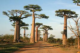
les baobabs ce n'est pas vraiment la région.excepté autour de majunga.
Les Baobabs c'est avant tout à Morondava sur la côte ouest!!
Mais d'abord il faut savoir quand tu veux faire ton voyage car si c'est en saison des pluies ça va pas être facile!! meme les 4x4 sur la côte est ça passe pas!! Et de Diego à Antalaha c'est de la piste sur plusieurs jours avec passages de bacs.. ensuite 3 ou 4 jours à pied dans la boue et la jungle jusqu'à Maroantsetra ( la vraie aventure!! pas comme avec "nouvelles frontières"!!)..puis ensuite aller à Mananara... avant c'était de la piste!! Maintenant je ne sais pas
De Mahajenga jusquà Diego je l'ai pas fait mais ça doit être à peu près pareil! j'espère que tu connais le confort du taxi brousse et la longue attente pour le remplir dans ces régions sinon la découverte va être rude!
Sinon un coin magnifique : la baie d'Antongil à Maroantsetra! ( ya une réserve biologique ou quelque chose comme ça maintenant)
J'espère aussi que tu n'es pas trop pressé..j'en vois des fois qui voudraient faire le tour de Mada en 15 jours..les pauvres s'ils pouvaient imaginer ce qui les attend!!
Bon courage!
PS : en posant ton message dans la rubrique "voyage à pied" ça laisse supposer que tu veux faire tout ça à pied or tu parles de taxi brousse.. A pied c'est pus d' un mois de voyage ( sans mollir!)
Oui on trouve des guides ou pseudo guides sur place..mais perso je l'ai fait dans l'autre sens..et c'est pas de la tarte!
Pour quelle raison t'as posté ton message dans " voyager à pied" ? on utilise en principe cette rubrique pour la rando les trekkings les longs périples vraiment à pied...
Pour Mada n'oublie pas ( surtout pour toute la côte est!!!) qu'en saison des pluies certaines pistes et surtout la partie à faire à pied ( ya une raison si aucune piste ne travers cette partie de forêt primaire!!) sont totalement impraticables!
Je l'ai fait sans guide, mais ce n'est pas recommandé. Le chemin n'est pas toujours facile, traversée de rizieres, de cours d'eau. apres ça dépend aussi de l'eau qui tombe du ciel, de la période, et surtout de sa condition physique et motivation!
Pour ma part, le choix de la région est adapté parfaitement à ce que vous semblez rechercher à Mada. Hors des sentiers battus, de la marche... Bcp de raisons de choisir donc d y passer du temps car c est une région pas facile d acces. Pas besoin de se disperser donc.
Concernant les baobabs, on les rencontre surtout a l ouest et au sud. Neanmoins on peut aussi en voir a Diego mais ils ne sont ni aussi "connus", ni aussi grands que ceux de Morondava ou ceux qui je crois sont près du parc du Zombitse par exemple.
Ci dessous un lien vers un site d un couple qui a vécu et fait un beau tour de Mada. les photos sont belles et sur mai / juin et juillet 2011 il y a les posts et photos relatifs au nord. Malheureusement aout a été supprimé car ils y décrivaient leur trek, le parc de Marojejy aussi qui est magnifique... http://detours-et-deroutes.blogspot.com/
ok merci une derniere chose vu qu'ont i va au moi mai le sentier de diego a st marie sera pratiquable ?? et es qu'il y a des cabane pour dormir ou fo t il enmener une tante pour les 4 5 jour de balades
Bonjour... je me permet de rentrer dans la conversation car je me pose des questions quand je voix que tu écris Diego St Marie une balade de 4 a 5 jours et à savoir si le sentier sera praticable ... si tu veux le faire à pied tu n'es pas arrivé et si tu le fais en 5 jours alors là je te tire mon chapeau prend une carte et repense ton projet ....c 'est juste un petit conseil...
Michel
Pour information, j'ai fait Anthala/Tamatave en vélo, il faut 15 jours sans jour de repos et en prenant le bateau de Cap Masoala et Mananara. C'est une piste d'Antahla à Mananara. Tu trouves à dormir partout, le tout est d'aller de village en village, car souvent c'est la pampa. Donc pas de tEnte.
Pour information, j'ai fait Anthala/Tamatave en vélo, il faut 15 jours sans jour de repos et en prenant le bateau de Cap Masoala et Mananara.
C'est sûr!...... que dire alors de Diego Suarez à Mananara?! et à ce trajet il faut rajouter Majunga-Diego! alors combien de temps au total ? 2 mois?
Pour Babos 38:
Le plus facile le moins long le plus beau le plus sympa ( bien que tous les goûts soient dans la nature!)
..Aller à Tamatave en taxi brousse depuis Tana ( une des meilleures routes de Mada si aucun cyclone n'est passé par là!).. de là aller à Foulpointe(50km) au nord ; y passer quelques jours au bord du lagon ( loger au gentil pêcheur.) ya pas trop de choix sauf si on opte pour plus luxueux ( 3fois plus cher!) et souvent totalement désert!) Ensuite une fois retapé monter plus au nord (Je me souviens plus de l'endroit pour prendre le bateau un peu au nord de Fénérive pour Sainte Marie) et aller à Sainte Marie et l'île aux nattes loger au "rocher" chez Emilienne! à Maromandia au nord d'Ambodifotatra( attention si la mer est mauvaise à éviter! ya déjà eu des naufrages et de nombreux disparus!) et s'il vous reste du temps ( pas sûr) et du courage ( il en faudra) rejoindre la côte et monter jusqu'à la baie D'Antongil ( Maroantsetra)...ensuite partez pour l'aventure 3 ou 4 jours de jungle jusqu'à Antalaha! ( la côte de la vanille) si vous le faites dans ce sens ça m'étonnerait que vous ayez envie de le refaire dans l'autre sens... Donc le seul moyen d'en revenir c'est l'avion!
nous ne voulon pa tous faire a pied mais en taxi brousse, je vouler juste savoir le moyen daller de la cote de diego a l'otre cote ver sainte marie le plus cour possible mai on ma dit qu'il n'y ave pas de piste pour yaller en taxis brousse donc combien de jour de marches faut il , pour retrouver des taxis brousse, pour rejoindre l'autre cote
Cher ami, je crois qu'on t'a déja répondu : 3 ou 4 jours. et en Mai il ne devrait pas y avoir trop de pluie. Pas besoin de tente non plus , tu peux dormir dans les villages. Mais ce qui m’inquiète à ton sujet c'est que tu donnes l'impression de partir vraiment à l'aventure, sans preparatifs et dans un pays inconnu de surcroît. As tu au moins une carte et un guide de voyage?
voila de retour apres un mois de bonheur , cette ile est exeptionnelle , la nature est tres riche , les malagaches sont tres accueillants et chaleureux , mefiance tous de meme surtout dans les grosses villes .nous avons fait tana majunga , majunga nosy be , nosy be direct nosy komba , nosy komba ankarana , ankarana diego tous en taxi brousse ensuite nous avons pris l'avion diego tana obliger de repasser par la capital en avion gros point negatif de air mada et pour finir nous pris le taxis brousse pour andasibe , andasibe tamatave , tamatave foulpointe et retour a la case depart.
voila de retour apres un mois de bonheur , cette ile est exeptionnelle , la nature est tres riche , les malagaches sont tres accueillants et chaleureux , mefiance tous de meme surtout dans les grosses villes .nous avons fait tana majunga , majunga nosy be , nosy be direct nosy komba , nosy komba ankarana , ankarana diego tous en taxi brousse ensuite nous avons pris l'avion diego tana obliger de repasser par la capital en avion gros point negatif de air mada et pour finir nous pris le taxis brousse pour andasibe , andasibe tamatave , tamatave foulpointe et retour a la case depart.
Je projette d'aller de Majunga à Nosy Be fin octobre. Ton itinéraire Majunga - Nosy Be en Taxi brousse m'intéresse. Quelles ont été tes étapes ?
Donc nous ont a pris le taxi brousse de majunga a ambanja 12h de route , aprés ambanja , ankify dans la foulé environ 2h de route et la t'embarque pour nosy be navette rapide 10000 ar entre 20 et 30 min de bateau voila voila
12 h de taxi-brousse, ce n'est plus de mon âge ! Je pense que nous ferons étape à Ansohihy et que nous en profiterons pour aller à Analalava.
En tout cas, merci de ta réponse.
J’aimerai explorer le nord-est de Mada, utilisant les taxi-brousse, bateaux ainsi que mes jambes. J’ai déjà un itinéraire idéal en tête, cependant j’aimerai…
Je prépare mon voyage sur Madagascar où nous comptons nous déplacer (4x4 avec chauffeur et treks) et je voulais connaître les astuces que vous pourriez me…
Je suis en train de voir la faisabilité d'un voyage à madagascar en juillet-aout 2020. Je chercher à faire des rando en autonomie dans la nature (c'est à dire…
J'aimerais savoir si il y a des lieux sympa et qui ne craignent pas où on peut randonner sans guide (en dehors des parc nationaux donc je suppose). Plutôt avec…
Bonjour,
Nous souhaitons faire le trek de 4 jours reliant Mestia à Ushguli sans agence. Il est précisé dans les descriptifs qu'il existe des hébergement à chaque étape, mais on ne trouve pas d'info sur ces hébergements. Quelqu'un a-t-il des infos et un avis sur ce parcours?
We're planning to trek in Peru and Bolivia and would love to find some local agencies.
If you know any, could you share details on prices and, of course, the names of the agencies?
Which trek would you recommend?
Elocine
Je pars en autonomie totale sur un trek au Maroc (10jrs) Imilchil - Aghbalou.
Trouve t-on des cartouches gaz à vis (Coleman, Primus) à Marrakech (adresse) ou villages entre Imilchil - Aghbalou ?
Si non , trouve-t-on des cartouches Butagaz pour camping-gaz (petit volume 230 gr ...)
Merci d' avance pour vos réponses
Hello, I’d like to embark on a little trip in my home country, Switzerland. I’ll start walking from La Cure, heading toward Le Noirmont first, then I’ll improvise my route—but it’ll probably follow the French border... at least as far as Lac de Joux.
I’ll decide day by day how much farther to go after that. My goal is to stay in nature as much as possible, wander around for as long as I can, and restock food in villages or towns along the way.
I’m thinking of mostly camping, but we’ll see if I end up in a hotel or another campsite depending on my route.
I’d love to reach La Chaux-de-Fonds on foot... maybe even Delémont.
The whole thing should take about a week, give or take.
I’ll be bringing my dog, and I’m preparing for this as soon as I’m ready.
Any tips to make sure everything goes smoothly for us? Things I should know—or avoid? What about shepherds with their flocks of sheep? And isn’t hunting season open right now?
I’m not sure if what I’m planning is even doable, which is why I’m asking around.
This’ll be my first time doing something like this—wandering in nature *and* with a dog. I’m really excited for this adventure... and I need it. Thanks!
We’re really keen on ecosystems and want to hike in "natural" ancient forests—not planted woods or areas heavily degraded by human activity. Travel guides (like Lonely Planet) don’t provide much info on this. Could you point us to the most interesting spots?
Thanks in advance for your tips.
We wish you happy holidays and a fantastic 2026, full of discoveries!
Claire and Albert
Hi, this might not be the right section, but I’d like to know if it’s possible to start mountaineering with another person without necessarily hiring a guide. We’ve done quite a bit of hiking but not mountaineering—we’ll just do a half-day glacier course. After that, we were thinking of starting with La Grande Motte and the Pointe de la Traversière, which were recommended to us. Honestly, for things like roping up and knots, I’ll learn at home with lots of videos and a book.
Hi,
I don’t know Switzerland at all and was wondering if Vallée des Joux and especially Dent de Vaulion are packed early in the morning or late in the afternoon in July and September?
If so, do you have any quieter spots to recommend in the area, or in Luxembourg (yes, I know it’s not the same country 😉)?
Thanks a lot!
I’m starting this thread—lots of travelers here have done this trek.
When RMS is mentioned, it’s this agency: Ruwenzori Mountaineering Services (with an *s*), because there’s another one online called Ruwenzori Mountaineering Service (no *s*).
Their site:
www.rwenzorimountaineeringservices.com/
From what I gather, it’s the local mountain guide agency certified by the government?
Jaimerais savoir si quelqu'un aurait fait des treks sur le Ruwenzori et combien ça coute en moyenne, les infrastructures, les paysages la sécurité sur les lieux, merci beaucoup. J'attends avec impatience vos réponses.
We’re leaving in 9 days for a two-week trip to Madeira, mainly to hike.
From my research, I’ve found that since last year, access to most trails—and systematically for the most popular ones—is now paid. You have to pay an access fee of 4.50 € per person per classified hike in 2026, and even 10.50 € for the most iconic hike: Pico Arieiro to Pico Ruivo. When paying, you also have to choose a day and a 30-minute time slot for your start time. Of course, this reservation is neither changeable nor refundable, even if the weather that day is terrible.
Personally, given the massive influx of tourists to the island in recent years, I don’t mind paying a fee to help maintain the trails. Similarly, setting a limit on the number of people who can hike them per day is certainly preferable to preserve this priceless heritage.
However, what’s much less fair is that in reality, most of the available spots are reserved: 1/ for Madeira residents (which is normal); 2/ for "economic operators" (meaning local tour operators). For example, if you’re a non-resident (independent tourist), no booking is possible for the Pico Arieiro hike for an early morning start before September! So, unfortunately, we’ll have to skip this hike.
It’s the same issue for Ponta de São Lourenço, the 25 Fontes, Pico Ruivo... in short, all the most popular hikes. Oh well, we’ll skip those too!
So my question is: which hikes do you recommend where we won’t face the huge crowds that the others get? And where we can book the day before for the next day, taking the weather into account?
Finally, a quick accommodation question: we’ve booked the first week in Funchal, but I haven’t decided yet for the second week. Do you have any advice on where to stay in the south or north, preferably avoiding overly concrete-heavy and touristy spots?
I’m reposting about the logistics for Samaria Gorge.
I’d love to get recent info, especially about whether it’s possible to park my car in Omalos, do the hike, and then catch a bus back to my vehicle.
In theory, it’s doable, but when you check the KTEL website, there aren’t any feasible schedules listed. If anyone has recently organized this with reliable, verified details, I’d really appreciate it. Thanks in advance!
Hi there,
We’re flying from Montreal to Lyon this August to go hiking in the French Alps. We’ve rented a car and will be staying at campgrounds. We’re planning to do day hikes and want to stay a few days in one spot, do a few hikes, then move on to our next camping spot. Could you share your favorite spots or any recommendations for places to spend a few days with great hikes?
A few details:
We arrive in early August and leave in early September.
We’re looking for day hikes (or shorter), moderate difficulty, with a cumulative elevation gain of no more than 1000m, and of course, beautiful scenery!
We’d prefer not to drive too much—maybe it’s best not to head too far south and deal with unnecessary heat?
Along the same lines, if you know of any great campgrounds where we can start our hike directly without needing the car, we’d love to hear your suggestions!
Bonjour
Souhaitant faire de la randonnée sur cette île, je voudrais d'abord savoir quelle serait la période la plus favorable sachant que j'avais passé quelques jours en novembre 2018 pas pour cette activité mais plus pour une simple découverte de l'île et le temps n'était pas top notamment en montagne. Donc peut on choisir une organisation en étoile sachant que je louerai un véhicule avec éventuellement 2 points d'hébergement.
Je n'envisage pas d'intégrer une structure mais de partir à 2 et de s'organiser sauf si vous me conseillez une agence locale ou un guide local. Enfin même si je compte me procurer les différents supports, carte et topo guide plus gps je vous remercie de bien vouloir me communiquer les randos à faire en priorité
Merci beaucoup pour vos informations
I’m planning to do the Mercantour crossing following the Randoxygène route in mid-July.
I’m used to hiking in the mountains, but I sometimes get vertigo, for example on ridges with drops on both sides. I wanted to check if there are any T4 or T3-T4 sections and find out if there are any very exposed passages—and if so, where—so I can plan an alternative route.
Can anyone give me some info on this?
Thanks!
I’m planning a trip around Cap Corse and the AGRIATES in 2026, from May 8th to 15th (there are still 2 spots left, by the way! Just DM me if you're interested).
I’d love to know which hikes are worth prioritizing in the AGRIATES. We’ll be staying in SALECCIA for two days as our base—what should we focus on from there?
A round trip to IGNHU beach? Any other suggestions?
For Ostricano, I think it’s too far for a round trip...
Thanks for your tips!
Have a great day,
Anie, Toulouse
I’d like to get some info about the GR10 Pyrenees traverse. I need help planning the daily stages and accommodations—my wife isn’t an experienced hiker but walks a lot, so I’d like to schedule shorter walking days and thus a longer overall trip in terms of number of days.
Could anyone give me some help and advice?
Best regards,
New to this forum, I’m planning a pretty big project for 2028.
I’m heading to Nepal to do a trek from Kathmandu all the way to Everest Base Camp (a cool 5,300 m 😄).
This trek is a bit special because even though I’ll be part of a group, I’m going solo (so far, no problem—I’m used to it). But it’s my first real trek, and it’s also a humanitarian one: once I reach base camp, I’ll stay an extra week to help clean up the waste left by tens of thousands of climbers! Since I’m originally from South America, from two countries that share the Andes, I have a deep respect for mountains—they fascinate me. So Everest… it’s kind of the trip of a lifetime!
So, a little question for those who’ve done treks to Everest before… any tips for good mental preparation (I’m already working on the physical side)?
Hi there, I’m planning the Annapurna Circuit for March 2027 and I’m looking for a local agency with a local guide—preferably French-speaking—to arrange this trek for us. Any suggestions? Thanks
Hello!
We’re spending a few days in Toraja country at the end of May. We’d love to do a day trek—taking our time—on a route that’s stunning in terms of scenery, but not a level 5 in difficulty!
Any suggestions you can share, please?
Thanks in advance
I’d like to do the Mare a Mare Sud in May over 4 days. I’ve found quite a few places to stay along the route, but I’m stuck on the start and finish.
I’ll be arriving by plane on Sunday evening and would like to start pretty early on Monday morning. Ideally, accommodation right at the trailhead (Alzu di Gallina) would be amazing, but I can’t find anything. Any tips?
Also, for the transfer from Figari Airport to Porto Vecchio or Alzu di Gallina?
At the end, I’d like to pick up a rental car—any advice on that too?
I’m traveling solo by plane to Catania in May and plan to hike the northern side of Etna, starting from Linguaglossa where I’ll arrive by bus. After that, I’d love some info on how to get up to Piano Provenzana (shuttles or hitchhiking), since it seems there’s no public transport except in the summer. Can you sleep there in a free or cheap refuge, or camp? And how far up can you go without having to hire a guide? Thanks in advance. Bernard.
Bonjour a tous,
je pars en voyage au Maroc en aout et nous allons commencer par nous arrêter a Chefchaouen(nous sommes en voiture).
Ma question: quelqu'un peut il m'indiquer un itinéraire de rando en boucle d'entre 5 et 7 jours aux départ de Chefchaouen dans le parc de Talassemtane passant si possible par le pont de dieux?Ou un guide papier qui en reunis quelques uns?
Nous privilégions le camping sauvage et les gites.
Merci d'avance
Hi there, for those who’ve been recently—is it possible to find other solo travelers in March on the island to share transport or room costs? It doesn’t seem easy to travel on a budget.
If you have any recommendations for simple lodgings or places with dorms, I’d love to hear them.
For those who’ve done multi-day treks while moving around: do you need to bring your own sleeping bag? I’d love to hear about itineraries you’ve done without a guide, just with a map and GPS.
Thanks, and have a great day!
Hi everyone!
We’re planning a 15-day road trip to Scotland this summer, specifically to explore and hike on Lewis and Harris—places we’ve never been before. We’ve visited other islands on previous road trips in Scotland (we usually go in April for a week). This would be our first time in Scotland in the summer and for 15 days. We’re looking at late August to early September.
I’m currently drafting the itinerary. We’d be crossing from Ullapool and were thinking of spending 3 nights on Harris and 4 nights on Lewis.
Does that sound balanced to you? Is it better to keep the same accommodation on Harris and the same on Lewis to explore the area? I’d love to hear about any past experiences you’ve had on these islands.
Thanks!
Hi there, I’m trying to leave for 15 days very soon to São Vicente. I’m either looking to join an agency or figure things out on my own to go hiking on one of these islands or both. From what I’ve seen, it’s not easy to organize with local transport, so it gets expensive. Can I use the services of a small local agency? I’m looking for the simplest way to hike for several days. Also, how do you get from São Vicente to São Nicolau? Thanks in advance and have a great day!
Aichatou
I’ve been wanting to do this for several years, and this year’s the one. Next September, I’ll be trekking in Tusheti (Georgia), from Omalo to Shatili.
Of course, I won’t be renting a vehicle that’d just sit unused. No problem getting to Pshaveli, but from there to Omalo, it’s a dirt road (still the case?)
There must be some form of public transport since there are so many guesthouses, and not all travelers come in a 4x4.
If any of you have been to Omalo, could you confirm that these shared transports exist and how often they run?
we’re planning a trip to Yellowstone and hoping to do a three-day backcountry hike if we get a permit.
if any of you have done this before, could you let me know if it’s possible to find water along the way? And if we can transport it, are we allowed to use a stove?