Bonjour tout le monde.
Je viens de regarder sur GoogleEarth la piste de Cathedral Valley.
Au niveau du gué (accès ouest), je vois 2 gués distant d'une centaine de mètres.
Lequel faut-il emprunter ?
Merci et bonne journée.
Je ne me rappelle pas avoir hésité 😇 donc je suppose que j'ai suivi la piste et donc le 2ème gué ?
Au pire, tu verras celui qui est le + court ou le moins profond 😛
Tout comme vazyvite, on n'a pas hésité non plus... J'ai mis une photo sur mon site de l'endroit où il faut traverser à angle droit, ça t'aidera peut-être:
Merci beaucoup Vazyvite.
La description de la piste que tu fais sur ton site est une aide précieuse pour préparer la journée consacrée à CV.
Merci encore.
tu ne peux pas la louper 😉. En descendant du camping, petite piste sur la gauche : embranchement à N38° 29.03 et W111° 21.67, vérifié sur Google Earth.
Voir photos attachées ; les EXIF y sont, dont les coordonnées GPS.
ça va mieux en le disant :
comme son nom l'indique les "cathédrales" sont dans la vallée,
donc les ombres s'allongent vite et elles se retrouvent plongées dans l'obscurité avant l'heure du coucher de soleil "officiel"...
Prévoir de la marge pour être sûr d'avoir un bon ensoleillement sur place ! 😎
Merci Pong.
J'ai prévu de dormir au campground ... on essayera donc d'arriver pas trop tard pour profiter des monolithes en pleine lumière.
Jean Michel.
Très bonne idée le camping sur place : c'est magique !
(et un peu flippant quand y est seul !)
La route qui y mène est si belle
(j'avais commencé par le gué dès le départ, donc dans le sens des aiguilles d'une montre il me semble...)
que je me suis arrêté (trop ?) souvent pour prendre des photos,
et du coup je suis arrivé un peu juste pour les cathédrales !...🤪
C'est un endroit que j'apprécie particulièrement pour son ambiance... 😎
Très bonne idée le camping sur place : c'est magique !
(et un peu flippant quand y est seul !)
Flippant... à cause des pumas? ou des hommes? Parce que dans ces coins perdus il vaut mieux être seuls au contraire, enfin c'est mon point de vue...😉
Nous il y avait un type qui était là depuis un moment apparemment vu tout ce qui pendait un peu partout autour de sa tente, accrochés aux branches, etc. Pas vraiment sympathique... Il avait juste un vélo et je me disais que pour le ravitaillement en eau ça devait être costaud!
Au passage, il vaut mieux prendre l'entrée à Caineville si on dort au camping, et sortir le lendemain par le nord. Mais ça implique d'avoir déjà parcouru auparavant l'autre partie, celle du gué, sinon il manque quelque chose.
Sympa la photo depuis l'intérieur de la voiture ou camion.
Merci de tes infos et merci pour tes nombreux posts qui me sont très utiles pour préparer mon voyage dans l'ouest.
Jean Michel.
A cause des ennuis mécaniques possibles (crevaisons, surchauffe du moteur, panne, ...) plutôt ! 😇
Le Visitor Center m'a gentiment prévenu de prévoir 3 jours d'autonomie en eau et nourriture,
car la fréquence de passage d'une voiture pour obtenir de l'aide peut atteindre ce délais !...
(sans compter qu'il n'y a bien sûr aucun réseau...) 😉
J'ai apprécié la solitude au pied des cathédrales,
mais j'ai vérifié 2 fois qu'il n'y avait aucune veilleuse allumée quelque part (ou appareil en charge)
pour être sûr que ma batterie ne me laisse pas tomber au petit matin...
Pour la meilleure orientation du soleil, il faudrait relire le PTSW :
cependant, les formations sont assez "petites" pour en faire le tour, du coup, ce qui compte le plus je pense,
c'est d'arriver à temps pour la Golden Hour (surtout le soir, mais aussi pour le matin, prévoir le réveil matin au besoin...)
et comme il est souvent répété sur PTSW, rechercher la "lumière réfléchie" :
J'ai bien aimé faire le tour dans le sens des aiguilles d'une montre,
car les formations sont très belles le long de la route, plutôt variées,
et le lendemain, il restait surtout les différentes "cathédrales",
mais ça m'a paru plus court, du coup, d'une certaine manière, le plus long était fait,
et du coup, comme l'étape suivante était à l'hôtel, j'étais content d'arriver plus vite pour une bonne douche ! 😎
et sur les photos, ça m'a l'air pas mal le matin (temple du soleil je crois...) 😊 😎
Je dirais qu'en entrant par Caineville il faut d'abord te renseigner si tu pourras ou non passer le Ford de l'autre côté, sinon sortir par la piste nord, celle des Thousand Lakes. Pour nous la rivière était impassable, d'après les rangers. Donc en entrant par là, tu auras le coucher de soleil au primitive campground et en plus le lever!
De toute façon de quelque côté que tu entres il faut d'abord passer au Visitor info pour le gué.
Moi je préfère la boucle dans le sens contraire des aiguilles d'une montre, contrairement à Pong 😉.
Superbes photos!! Tu as bien su saisir la lumière, c'est magnifique! 🙂
Pour les ennuis mécaniques je dirais qu'il n'y a pas plus de risques là qu'ailleurs... Il faut évidemment quand même se renseigner sur l'état de la piste, elle est régulièrement damée mais on peut mal tomber. Une fois, les rangers nous avait dit qu'il y avait de la roche, etc., d'être très prudents... On n'a rien vu de spécial... Mais il faut rouler en ayant toujours à l'esprit le caillou pointu qui risquera de se planter dans le pneu (et ça sur n'importe quelle piste de toute façon). Sinon, avec un minimum de prudence, c'est OK.
Tout dépend de la saison, pour le passage. C'est sûr qu'il n'y a pas foule, mais bon, on croise bien une voiture sur les huit heures 😉 quand on fait la boucle complète.
Bonsoir Pascale,
Merci pour ton message ! 🙂
Pour ce qui est de la route, je suis d'accord avec toi,
je n'ai pas trouvé que c'était pire qu'ailleurs,
mais, sur les conseils de Sedonax, je n'ai jamais dépassé les 30 m/h (50 km/h),
car c'est souvent la vitesse qui entraîne la crevaison, même sur des pistes "roulantes"...
Pour la fréquence de passage, j'étais un peu "hors saison" au début du printemps, alors ça ne se bousculait pas au portillon !...
(ce qui expliquait également que les 5 places de camping étaient vides
et que je n'ai croisé personne sur les 2 jours, à part de vrais "cowboys" locaux à cheval...)
et pour le "sens de la visite", maintenant je me souviens que l'idée était de traverser dès le début le fameux gué (si c'était possible),
plutôt que devoir rebrousser le chemin de l'autre coté (comme sur le lien que tu as donné).
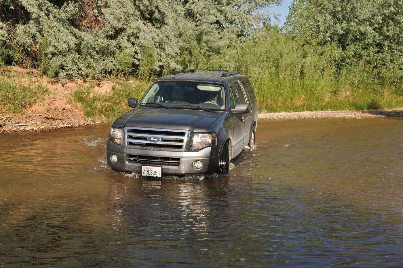
Finalement, c'était plus impressionnant qu'autre chose, car le courant n'était pas bien fort...
J'ai regretté de n'avoir personne pour prendre quelques photos de ma voiture entrant droit dans la rivière !!!! 😏
(et je n'ai pas osé la laisser au milieu de l'eau -le temps d'aller prendre un cliché de l'autre rive- )
déjà que le loueur m'avait bien rappelé que les assurances ne fonctionnaient pas en dehors des routes goudronnées,
je serais curieux de savoir ce qu'il penserait des "lits de rivière" !... 😇
ça aurait donné quelque chose comme ça (trouvé sur le net) :
(il faut avoir confiance car on ne voit pas le fond :
pour se rassurer on peut déjà le traverser soi-même à pied pour se rendre compte de la profondeur...)
car c'est souvent la vitesse qui entraîne la crevaison, même sur des pistes "roulantes"...
Ça c'est bien vrai et je fais toujours très attention à ça. Je suis d'ailleurs très contente de n'avoir crevé qu'une seule fois dans tous nos voyages en Amérique du Nord ou du Sud depuis vingt ans 🙂, et encore, on s'était chopé un clou sur le parking de San Xavier Mission, dans le sud de l'Arizona 😕. Mais ça ne m'empêche pas d'adapter ma vitesse à la piste et j'ai déjà roulé à 100, notamment dans le sud du Chili. A Cathedral Valley il ne vaut mieux pas, tu as raison, ne serait-ce parce que le paysage mérite mieux que de passer en quatrième vitesse! 😉
Pour la fréquence de passage, j'étais un peu "hors saison" au début du printemps,
Nous aussi, les deux fois c'était en mai, et la première fois on était en berline donc on avait été uniquement sur la Scenic Drive.
plutôt que devoir rebrousser le chemin de l'autre coté (comme sur le lien que tu as donné).
Je sui étonnée qu'Annie ne soit pas passée par le nord, car c'est Philippe qui m'avait indiqué cette option et Annie aussi connaît bien Philippe. Donc plutôt que de refaire la piste en sens inverse, autant ressortir par la belle et très dépaysante piste du nord, qui passe dans les forêts d'aspens, ceux qui ont de grands yeux tristes 🙂.
Pour le Ford il faut se fier aux rangers. Mais au cas où, pour passer un gué un peu profond, il faut y aller carrément pour créer une petite vague de chaque côté qui évite de noyer la voiture. Evidemment, le plus intéressant est de savoir si le fond est plat 😉, et ça c'est une autre histoire!
C'est effectivement du vécu.
Il y a quelques années, au Canada, dans le parc de Banff.
C'est une martre d'Amérique ... très curieuse puisqu'elle a passée une dizaine de minutes à nous observer depuis l'entrée de son terrier.
On a même cru un moment qu'elle allait venir jusqu'à nous. Elle s'est rapprochée jusqu'à 2 ou 3 m.
Un excellent souvenir.
Merci encore pour ton aide.
C'est surtout de la chance (être au bon endroit au bon moment) et de la patience (pour que la martre prenne confiance et ne nous considère pas comme un danger).
Exactement ! 😏
Tu aurais un petit lien qui aboutisse directement vers ton expérience à Cathedral Valley ?
Tu as tellement sillonné l'Ouest que j'ai un peu de mal à m'y retrouver ! 🤪 😇
Tu aurais un petit lien qui aboutisse directement vers ton expérience à Cathedral Valley ?
Tu vas un peu trop vite en besogne 😉, je suis en train de terminer Horseshoe Canyon et Cathedral Valley sera la prochaine page de notre site. Pour l'instant, tout ce que j'ai c'est la partie texte de notre carnet 2012 (en signature), page 2 mais il n'y a pas grand chose. D'ici une quinzaine de jours peut-être.
Tu as tellement sillonné l'Ouest
Tu rigoles ou quoi 😉😎😎😎😎, je n'y suis allé que 2 fois. Bon, d'accord, à chaque fois un peu plus longtemps que la moyenne 😇, mais ce n'est rien comparé à des gens comme Philippe ou Thierry (ouestusa.fr).
Tu vas un peu trop vite en besogne 😉,
je suis en train de terminer Horseshoe Canyon et Cathedral Valley
Ah ! Il me semblait bien que je n'avais pas encore vu ces photos ! 😇
Quand tu les auras mis en ligne,
merci de mettre un lien dans ce fil de discussion,
je suis sûr que ça intéressera les lecteurs de ce Topic ! 😎
Hi there,
We're thinking of driving Route 66 from Chicago to LA in fall 2027 or spring 2028 for about a month.
From what I've found, it doesn't exist everywhere anymore, but that's okay! We're happy to take detours along the way. We're open to visiting less touristy or even completely off-the-beaten-path spots.
Are there any websites dedicated to this road trip?
I'd love any tips and advice for this journey—accommodations, vehicle rental, the pros and cons.
Thanks in advance!
Hi fellow travelers, do you think there’s a real benefit to spending 2-3 days in Yosemite when I’ll already be spending a week in Banff and Jasper in the Canadian Rockies? Won’t it feel a bit redundant? I’m asking because Yosemite is expensive (I’d go with an agency from SF, staying in a cabin, since I’ll be solo and without a car) and apparently packed.
Thanks for your feedback!
Hello! The itinerary is pretty much set for August 2026. Yeah, I know it’s gonna be *super* hot. But it’s the only time we can get away.
So, here’s the plan: Montpellier-CDG-Dallas.
Stay from July 31 to August 26, 2026:
Car rental – check,
Hotels – check,
Itinerary – almost check,
Photo gear – check,
Budget – check, 🤪
Meal planning – meh, we’ll see...
Walmart, of course, for the cooler when we arrive.
And now, without too much detail...
Fort Worth:
The Longhorns and the Stockyards;
JR’s ranch (for the missus);
Medal of Honor Museum – Arlington.
Houston and NASA Space Center:
See the Gulf of Mexico/America.
San Antonio and the missions.
Fort Stockton for an overnight stop.
El Paso via Guadalupe Mountains:
El Paso and White Sands.
Tucson and the Pima Air & Space Museum:
Tombstone, Bisbee.
Phoenix:
Still working on the program.
Sedona:
Round trip around the area via Flagstaff and Williams, or the Grand Canyon (already done) – we’ll decide on the spot.
Albuquerque:
Santa Fe,
Turquoise Trail,
Los Alamos.
Amarillo via Route 66:
Old Route 66 in the city;
Big Texas Ranch Steak 😏.
Dallas:
JFK Museum;
Perot Museum;
West End district.
And through it all – the road, the road, and more road!!!
We’ll adapt day by day based on our mental and physical state (we’re not exactly spring chickens).
Hello!
We’ll be arriving in Montreal on October 21st for a 3-day stay.
After that, we’re heading to Sherbrooke to visit our daughter, who’s studying at the university there. We’ll spend 3 days with her, and then, since she has a break that week, we’re taking her along for 3 days in Quebec City.
We’ve planned to visit Montmorency Falls and Île d'Orléans.
I’d love to hear what route you’d recommend for the drive from Sherbrooke to Quebec City—we’ll have the whole day to take it easy.
If you have any other recommendations, I’m all ears!
A little disappointed that the fall colors will be over by then, but the dates couldn’t be helped. Thanks in advance for your tips!
Hello everyone,
We’ve planned a trip (retired couple) for late August to the first half of September in Western Canada.
Classic itinerary: arrival in Calgary, Banff, Jasper, Clearwater, Whistler, Vancouver Island, departure from Vancouver.
I know you can’t see into the future any better than I can, so I’m obviously not asking what the wildfire situation will be like in a month...
But if any of you could let me know if, CURRENTLY, there are major difficulties—not just for locals, of course, but for tourists as well?
We’re hesitating between taking the chance or canceling what we still can.
We’re not young anymore and don’t have the flexibility we once did...
A thousand thanks to those of you on the ground or with contacts there who can help us make this decision!
A friend is renting a car for an upcoming trip during the All Saints' holiday.
Nowadays, all rental cars come with GPS, but do you know if you can use it without paying for the GPS rental? I have no idea since I always use my own!
After our first trip as a young couple to the West in 2007 (yes, that doesn’t make us any younger!), we’re planning to go back in 2028, but this time as a family of four! (We have two boys who’ll be 5½ and 13 years old in the summer of 2028.)
Our plan is to combine a few big cities (SF and LA, maybe San Diego) with national parks and state parks, mostly!
Ideally, we’d like to leave at the end of June and head back to France around July 19–20, so we can enjoy the first week of the Olympic Games in Los Angeles.
Since we already did the "loop" in 2007, there are must-see places we absolutely want to revisit—and especially share with our kids: Bryce Canyon, Yosemite, and above all, the Grand Canyon, which is still the most incredible thing I’ve ever seen on Earth!
On the other hand, some places didn’t leave a big impression on us for various reasons, so we’re not making them a priority: Antelope Canyon, Monument Valley, for example.
We’re planning ahead, but might as well be smart about it😏
Do you have any tips for a fun and doable itinerary over about 20–25 days with kids, without rushing?
hi everyone
I’m planning a world trip and I’m looking for great tips on accommodation in the United States.
Do you have any good deals to share, please?
thanks
Hello everyone! Really damaged due to flooding caused by runoff after forest fires (a total mess!), does anyone in this friendly forum have any updates on the Apache Trail between Apache Junction and Roosevelt Dam? Is there still a section of the road that’s tough to navigate?
We're leaving at the end of June and will be driving the route between Buffalo and Cody. We’ve already booked our accommodations and a rodeo in Cody, but during the day, we’ll be driving between the two and I’m unsure about the itinerary.
Which route do you think is the most pleasant, interesting, or scenic between:
- The northern route via Highway 14 with Sheridan, Lowell, etc.
- The southern route with Highways 16/20/14, passing by Loaf Mountain Overlook, Powder River Pass, Ten Sleep Canyon...
We’ll be in a car, so we should be able to drive on any road.
Thanks for your input!
I’m almost done planning our September road trip. After our 3-night visit to Sequoia, we’ll have a stopover night in Coalinga (to break up the drive). We’ll be staying two nights in Monterey and would like to stop along the way to visit one side of Pinnacles National Park. We’re torn between the West entrance and the East entrance, and we’d like to do a short hike of no more than 2 hours since we don’t want to arrive too late in Monterey.
This park is split into two distinct zones with no connection between them, and the mileage from Coalinga to Monterey is pretty much the same for both. Which area do you recommend visiting—east or west? And which route is the most scenic?
I’ve spotted two short hikes:
- East: Moses Spring to Rim Trail Loop
- West: Balconies Cliffs Cave Loop
Has anyone been there, or do you have another hike to suggest?
Thanks in advance, and have a great afternoon!
Marcalamar 🙂
Hi everyone! 🙂
Just a quick question about King Canyon and Sequoia National Park.
Before our night in Miramonte, we plan to visit King Canyon. The next stop will be two nights in Three Rivers to explore Sequoia National Park. I wanted to go all the way to Roaring River Falls on the King Canyon Scenic Byway and then turn back to head to Miramonte. Since we’re coming from Oakhurst, Google Maps says it’s 300 km and 5 hours of driving. Since we also want to hike to see the sequoias (Big Stump Area and Grand Grove) before tackling the King Canyon Scenic Byway, the timing’s going to be tight. How far do you recommend going before turning back to miss as few points of interest as possible on the King Canyon Scenic Byway? Thanks for your advice, and have a great evening!
Marcalamar 🙂
Hi everyone!
After years of hoping, waiting, planning, then changing, saving, and searching for the best possible route... we're FINALLY off this summer for a 5-week road trip in the West.
I had planned a trip to Colorado in 2021 but canceled due to COVID, so with time passing and my eldest’s high school graduation approaching fast, I figured it was now or never!
Anyway, the itinerary has been modified and extended to please everyone (I’m no longer the only one making decisions!!)
Here’s our final route:
Day 1 - 7/12/2026 - Brussels / Los Angeles
Day 2 - 7/13/2026 - Los Angeles
Day 3 - 7/14/2026 - Los Angeles
Day 4 - 7/15/2026 - Los Angeles
Day 5 - 7/16/2026 - Los Angeles
Day 6 - 7/17/2026 - Los Angeles / Kingman
Day 7 - 7/18/2026 - Kingman / Grand Canyon
Day 8 - 7/19/2026 - Grand Canyon / Page
Day 9 - 7/20/2026 - Page
Day 10 - 7/21/2026 - Page / Monument Valley
Day 11 - 7/22/2026 - Monument Valley / Durango
Day 12 - 7/23/2026 - Durango
Day 13 - 7/24/2026 - Durango
Day 14 - 7/25/2026 - Durango
Day 15 - 7/26/2026 - Durango / Glenwood Springs
Day 16 - 7/27/2026 - Glenwood Springs
Day 17 - 7/28/2026 - Glenwood Springs / Moab
Day 18 - 7/29/2026 - Moab
Day 19 - 7/30/2026 - Moab
Day 20 - 7/31/2026 - Moab
Day 21 - 8/1/2026 - Moab
Day 22 - 8/2/2026 - Moab / Vernal
Day 23 - 8/3/2026 - Vernal / Grand Teton
Day 24 - 8/4/2026 - Grand Teton
Day 25 - 8/5/2026 - Grand Teton / Cody
Day 26 - 8/6/2026 - Cody / Yellowstone
Day 27 - 8/7/2026 - Yellowstone
Day 28 - 8/8/2026 - Yellowstone
Day 29 - 8/9/2026 - Yellowstone
Day 30 - 8/10/2026 - Yellowstone / Salt Lake City
Day 31 - 8/11/2026 - Salt Lake City / Bryce Canyon
Day 32 - 8/12/2026 - Bryce Canyon / Zion
Day 33 - 8/13/2026 - Zion
Day 34 - 8/14/2026 - Zion
Day 35 - 8/15/2026 - Zion / Las Vegas
Day 36 - 8/16/2026 - Las Vegas
Day 37 - 8/17/2026 - Las Vegas / Los Angeles
Day 38 - 8/18/2026 - Los Angeles
Day 39 - 8/19/2026 - Los Angeles / Brussels
Day 40 - 8/20/2026 - Brussels / Home
We’ll be alternating between house swaps, motels, and campgrounds. I’ve booked all the accommodations (except the campground at Bryce since sunset bookings open only 14 days in advance) and the first activities, as well as the most touristy ones.
I’m currently putting together my day-by-day roadbook and having some trouble planning certain days, like in LA or Las Vegas. Choosing hikes isn’t easy either—it’s tough to decide!
We’re really excited but could definitely use your help with choices and optimizations!!
Hello.
I’d like to travel along I-15N from San Diego to Las Vegas with my mom, who’s 67. We’ve explored Northern California and the California Coast over the past two years and now want to continue through the desert.
There are several attractions along the way:
- Mormon Rocks
- Desert Discovery Center and visit the Old Woman meteorite
- Joshua Tree National Park
- Mojave Desert
- Mojave National Preserve
- Anza-Borrego Desert State Park
- Silverwood Lake
My mom has back issues that prevent her from hiking or walking on trails with elevation changes. Is it possible to visit these places by car, or are the routes flat enough?
I’d love for her to experience the desert with an itinerary adapted to her condition. I’m also open to other points of interest that aren’t mentioned. We have 3-4 days for the trip, so we’re not in a rush—just want to explore.
I’d love to take a road trip and visit Nova Scotia. I’d appreciate some info on the best cities to see and the most interesting spots. The trip should last about 10 to 15 days, staying in hotels or motels. Thanks in advance!
We’re being relocated to Saint Pierre and Miquelon.
We’ll be taking the flight from Nantes to Montreal and then from Montreal to Saint Pierre.
Could you recommend a hotel near the departure terminal that allows dogs?
Hi,
My 16-year-old son is flying to Grand Rapids with other kids his age. There’s a layover in Detroit. There’s no unaccompanied minor service available. Is it pretty easy to navigate Detroit Airport to catch the connecting flight to Grand Rapids (domestic flight)? There are several of them who speak English well.
Thanks for your replies,
Good evening, everyone! 🙂
Just a few last questions to wrap up our Lake Tahoe visit plans.
**Parking:**
We’d like to walk to Eagle Falls and then Eagle Lake. I’ve spotted two parking lots that seem close to each other and give access to the trailhead. Where and how do we pay for entry to Emerald Bay State Park and Inspiration Point?
**Viewpoints on the East Side:**
Are most of the viewpoints (Balancing Rock, Granite Cave, Bonsai Rock, etc.) right by the road, or do you have to hike to reach them?
**Donner Memorial State Park:**
Is it worth making a detour to Truckee to visit this park and the Truckee historic downtown?
Hi there. I'm shocked by the price of the Upper Antelope Canyon tour—$175 for less than an hour… You might say, "if you can’t afford it…" But the real question is whether it’s really worth it, because $350 for two makes me feel like I’m getting ripped off. For those who’ve done both Lower and Upper, can you tell me if the price difference is really justified? Thanks
Hi everyone! 🙂
As you can see, we're heading back from September 6th to the 27th.
Everything’s booked for September—flights, accommodations, and the car. As I plan, I’ll be asking the experts for help. This is our second trip to California, but most of the stops are new to us.
We’ll start directly from San Francisco to our first overnight stop, Davis, before heading to Lassen Volcanic Park for 4 nights. Our flight lands at 12:50 PM.
Here’s our itinerary:
Day 1: Davis – overnight stop
Day 2: Red Bluff – exploring Lassen Volcanic Park (scenic drive to Lake Helen)
Day 3: Susanville – scenic drive through the park via the South Entrance, points of interest, and hikes
Day 4: Susanville – Cinder Cone and Painted Dunes hike
Day 5: Susanville – Warner Valley (hikes)
Day 6: South Lake Tahoe
Day 7: South Lake Tahoe
Day 8: Mammoth Lake
Day 9: Mammoth Lake
Day 10: El Portal via Tioga Road
Day 11: El Portal
Day 12: El Portal
Day 13: Oakhurst
Day 14: Miramonte
Day 15: Three Rivers
Day 16: Three Rivers
Day 17: Coalinga
Day 18: Monterey
Day 19: Monterey
Day 20: San Francisco
Day 21: San Francisco
Day 22: Departure
For hikes in Lassen Volcanic Park, I’ve planned:
Bumpass Hell, Cold Boiling Lake (Day 2)
Paradise Meadow (maybe not going all the way), Devastated Area, and the loop around Reflection and Manzanita Lakes (Day 3)
Cinder Cone and Painted Dunes (Day 4)
Devil’s Kitchen and Boiling Spring Lake (Day 5)
I’ve read there are trails to access the trailheads for Cinder Cone (11 km) and Warner Valley. Are these easy trails for an SUV?
Are there any other must-see spots or things we shouldn’t miss?
That’s where I’m at for now. Thanks for your replies, and have a great evening!
Marcalamar 🙂
I’m a total USA addict. I’ve already done several road trips, including the East Coast and West Coast.
I’m here today because I’m planning to go back for another road trip on the West Coast. Possibly with one of my sisters and a couple of friends. It’s still just a plan for now, but I’m working on an itinerary in the meantime. Ideally, I’d leave in 2026, but I don’t have the exact dates yet—maybe April-May or September-October.
My last trip to the West Coast was in September 2014. We went for 2 weeks, but this time it’d be 3 weeks. What made me want to go back was simply a colleague who just left today. As I’m writing this, he’s on the plane. I’m so happy for him, but now all I can think about is going back.
Since I recently went to NY, I noticed that prices have really gone up. I assume the same is true for the West Coast? For 2 people over 3 weeks, what budget should I expect? We’re the type to watch our spending and find great tips.
I think we’ll arrive in San Francisco like the first time and leave from either Los Angeles or Las Vegas.
Thanks for advising me on the booking—should I reserve a room in the hotel or go for a cabin for the best view?
Should I get breakfast or not?
What do you think of the restaurant?
Hello, if the off-the-beaten-path enthusiasts are still around 😉, I’d love some info on tackling these trails. I’m not super familiar with the rules, risks, or what to expect—I’m looking for firsthand experience from folks who’ve done it on their own once or multiple times.
Hi everyone!
I’m planning a week-long family trip to NYC in October 2026. The focus is on museums and soaking up the New York vibe. I’ve been checking Airbnb, but the prices in Manhattan are through the roof. Since I don’t know NYC well, is it "wise" to look outside Manhattan? Any neighborhoods you’d recommend?
After our first trip to the West, we’d love to go back to see other must-see spots!
The stay would be from May 11 to 20, 2026—it’s short, but hey...
M11: Lyon to Las Vegas (overnight in Vegas)
T12: Route 66 – overnight in Grand Canyon (GC)
W13: Visit GC – overnight in Page
Th14: Visit Antelope Canyon / Horseshoe Bend – overnight in Monument Valley (MV)
F15: Visit MV – overnight in Moab
Sa16: Visit Arches / Dead Horse Point – overnight in Bryce
Su17: Visit Bryce – overnight in Zion
M18: Visit Zion / Valley of Fire – overnight in Vegas
Tu19: Return flight
What do you think? Could we add one more night somewhere? We’re not big hikers, so we’ll mostly explore the parks using shuttles.
Also, we’re all set—passports are good. Do you think one classic Visa card and one premium Visa card will be enough for coverage?
Thanks so much for your feedback, and happy holidays!
Hi North America forum crew,
Just a little post that might interest some of you:
Travelers to the United States | Photo Now Mandatory Upon Entry and Exit | La Presse