I’m looking for a trek itinerary for two people in Sweden—something authentic, varied, and spectacular (transport from Stockholm). My partner and I have experience in Norway (Dovrefjell and Jotunheimen) and would love to explore Sweden’s landscapes. Naturally, I’ve been considering the Sarek / Padjelanta / Stora Sjöfallet area. I haven’t decided on a specific destination yet, so I have a few questions and would love input from experienced travelers.
- Which region of Sweden should be a priority if we love mountains?
- Starting in mid-July, which summits in the Sarek / Padjelanta / Stora area are interesting and accessible without gear (crampons, rope, ice axe)? We have solid mountaineering experience and want to gain elevation without overloading our packs. Ideally, summits without crevassed glacier crossings and minimal technical climbing (easy scrambling).
- How many days does it take to complete the north-to-south traverse of Sarek?
I’ll take the liberty of bumping this thread with an additional question: what shoes or shoe combinations work best for crossing Sarek independently (hiking boots, high-top hiking shoes, trail runners, sandals, etc.)? From my experience, nothing is completely ideal for this kind of terrain.
My partner and I crossed Sarek from east to west in August 2024.
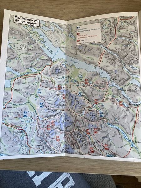
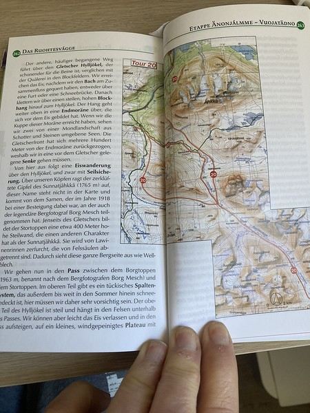
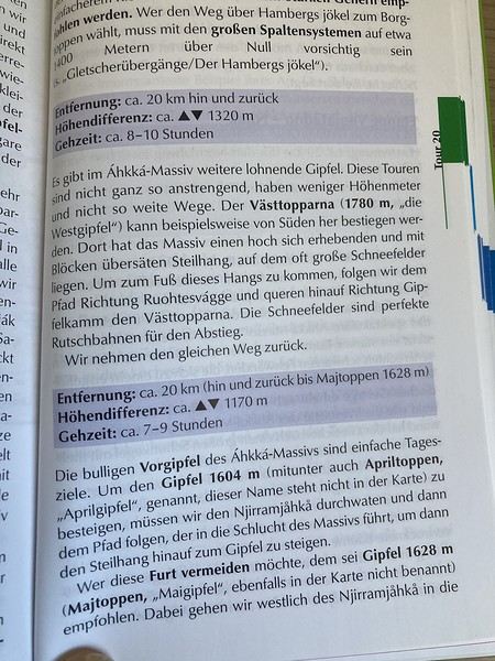
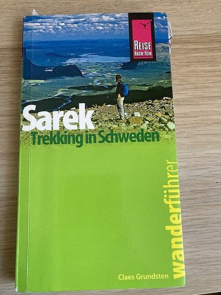
I based my planning on a book (which, unfortunately, is only available in German—thanks, Google Translate) that lists the different routes (with their difficulty levels) and accessible peaks.
From what I remember, the northern and southern routes aren’t the easiest.
The park is a paradise if you love mountainous landscapes, but there’s no signage or infrastructure—though I’m sure you already know that.
If you’re still interested (your message is a bit old now), I can take a closer look at the different routes and the peaks I’d identified along our route later this week.
I also hiked the Padjelantaleden in 2022, but it’s less mountainous (though the Akkha massif is nearby—I didn’t venture there).
Otherwise, you could check out the northern part of the Kungsleden, but it’s more crowded.
For footwear, I wore low-cut hiking shoes, while my partner had high-cut ones, plus Crocs—essential, in my opinion, for river crossings.
Thanks so much for your message. That’s really kind of you. Yes, I’d love some info on possible routes and summits. We’re thinking of crossing Sarek (Ritsem – Ruohtesvágge – Skárjá – Rapadalen – Aktse – Kvikkjokk), but we’re unsure about the direction—north to south or south to north. If the book is well done, I can probably buy it. Are there annotated maps with trails?
Also, about getting there—what’s the easiest and quickest way from Stockholm?
Feel free to share any tips or tricks about the area if anything comes to mind.
That’s exactly the route we took, except we started from Saltoluokta instead of Kvikkjokk. For crossing Sarek, it’s the easiest route according to the guidebook.
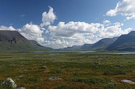
Honestly, the crossing is breathtaking—the landscapes are vast, and you feel completely immersed in nature in a way we’d never experienced before. You’re in for a treat.
We’re actually itching to go back.
I’ll send you the guidebook details later this week since I don’t have it on hand right now (though unfortunately, there’s no GPS track, and the maps aren’t very precise). We also bought a map (I’ll share the reference later this week).
To get back from Ritsem, we took the bus to Gällivare. Then there’s a night train that takes you back to Stockholm.
In 2022, when I returned from Kvikkjokk, I took the bus to Murjek and then the train to Stockholm.
That said, keep an eye on the train schedule—there are times when it doesn’t run, and I never really figured out why (a friend tried to take it last year, but it wasn’t running! I think it was early July).
In mid-July, the river crossings might be trickier than they were for us in mid-August, so stay extra cautious. I read that if you reach a crossing in the afternoon and find it too difficult, you should wait until the next morning (water levels rise in the afternoon due to glacial melt). Trekking poles are a real lifesaver for river crossings.
Make sure to build some flexibility into your schedule—we spent a whole day tent-bound at Skarja because of intense, freezing rain that didn’t let up all day.
I’ll give you more details later this week.
How many days are you planning for the trek?
I checked the trains for mid-July, and it seems there are no more direct options—you’ll have to change at Boden. Plus, before July 17th, there are scheduled works, and so far, there’s no guarantee that tickets will be available…
Thanks so much for your feedback and tips! Are you talking about the trains leaving from Stockholm?
Arriving at Saltoluokta seems like a better idea than Kvikkjokk since the station offers more services. As for the scenery, I’m not sure which is more interesting...
Good evening, I totally agree with Calisson94.
Be careful when crossing fords, especially if the water level is high.
And don’t forget to bring mosquito repellent.
The only time I went hiking in Swedish Lapland around Jokkmokk, starting from Porjus, I was literally eaten alive by mosquitoes.
Otherwise, it’s absolutely amazing—there’s no one around.
In terms of infrastructure, I preferred Saltoluokta—there’s a great kitchen for cooking and eating warm meals, or really good buffet-style food. And the tent sites are a bit more spread out, unlike Kvikkjok, where it’s one big area where everyone gathers.
That said, Kvikkjok is more low-key and has some amazing hikes (if you still haven’t had enough).
I don’t know the section from Aktse to Kvikkjok, so I can’t give you my take on that, but the most beautiful part will definitely be Sarek no matter what.
And 100% agree with Mathews—mosquito repellent (buy it in Norway, it’s more effective) and a head net too. We were lucky in mid-August because there were almost no mosquitoes, but we’d seen YouTube videos where it looked absolutely terrible
Following your PM, I’ll get back to you a bit later.
I’ll start by listing the summits I’d identified along the route.
Of course, there’s Skierfe above Aktse (but you’ve probably already spotted that one)—a must-do with a breathtaking view of Rapaladen.
Otherwise, in Sarek, here’s what I’d noted:
Around Skarki:
- Return hike to Laddebakte (NW of Skarki): 10 km, 940 m elevation gain, 4–6 hours. Climb to Snavvavagge lake, then straight up the moderately steep slope. One of the best viewpoints in the Rapaselet area.
- In the Jilavagge sector (northeast of Skarki): a dead-end valley ending in a massive amphitheater. Check out the crevasse with its waterfall in the wall below Soabbejahkka. There are vast grassy areas at the bottom of Jilavagge (possible bivouac spot here).
Svirjjatjahkka (1788 m): The ascent is a direct climb on steep, rugged terrain to the summit (there’s a huge snowfield here), then a narrow ridge to the broad plateau of Stuor Skoarkki (1842 m). 14 km, ~1120 m elevation gain, 6–8 hours.
Or from Svirjjatjahkka, a ridge hike north to Miehttse Skoarkki. Continue along a long, wide, and welcoming ridge to Soabbejahkka (stunning views of the Ahpar massif and the Bierikjavvre lake to the north). Then descend a steep scree field to the pass west of the summit, followed by a sharp climb to the 1647 m summit (amazing view of the Alktaj massif to the west). From there, a steep descent through a scree field to Snavvavagge (approx. 12 km, 1240 m elevation gain, 240 m loss, 220 m gain, 300 m loss, 120 m gain, 1050 m loss, 6–8 hours).
Around Skarja:
Mihkatjahkka + Vargtoppen—north of Skarja (best summits in the Sarek massif). Climb around Mihkajahka by crossing the glacial tongue of Mihkajiegna. 15 km, 1000 m elevation gain, 6–8 hours.
Skarjatjahkka (NW of Skarja). Easy to reach—climb the eastern ridge directly. 15 km, 1000 m elevation gain, 6–8 hours.
Svarta Spetsen (NE of Skarja). A pointed summit but easy to climb. 10 km, 1040 m elevation gain, 4–6 hours.
In Ruhotesvagge:
- Climb to Nijak (excellent observation summit, though no vast mountains around). 5 km, 1060 m elevation gain, 3–5 hours. Ascend via the southern slope—a steep, rocky slope that’s easy to scramble. Simple but tiring. The view from the top is endless.
Well, we didn’t do any of them ;-) because the weather wasn’t great when we were there, and we used up our buffer day staying in the tent during a non-stop rainy day. We only went up a little under Gisuris (and not even to the top).
Hiking in Sarek isn’t a walk in the park, so if you want to add summits, I think you should plan extra days.
Je pars au mois de juillet faire un trek en laponie suédoise qui se déroulera de kvikkjokk à ritsem en totale autonomie. Nous sommes 4 amis et partons en…
J'écris ici pour essayer de profiter de vos lumières:-) Je pars en juin pour 18 jours de marche au départ d'Abisko. J'ai vu qu'il est possible de faire une…
Voici un court récit ainsi que quelques photos de mon périple dans le parc national du Sarek, en Laponie suédoise. C'est mon premier carnet, soyez indulgents…
Je souhaite traverser le Sarek durant le deuxième et troisième semaine de septembre. Quelqu'un pourrait-il me donner des infos sur le climat possible. Je sais…
Avec 4 autres amis, nous aimerions faire un trekking de plus ou moins une semaine en Laponie, au Sarek National Park près de Jokkmokk au Nord de la Suède. Nous…
Hi,
I’ve found my upcoming trip for February, and now I’m looking for a one-week getaway in April—somewhere not too far with generally nice weather. Any tips?
Best,😉
Hi everyone, we’re a group of 11 people (including 3 kids under 4) who’d like to do a wine tasting tour starting from Florence (we haven’t rented a car) in Chianti.
We’re looking for an organized tour that leaves from Florence and lets the adults do some wine tasting (and olive oil tasting if possible).
For those who’ve done this tour, do you have any suggestions for tour names that organize these kinds of events? What should we look out for before booking these tours?
Hi, who’s familiar with the Algarve?
Lagos—should I go for a rental or a hotel? How do I get from the airport to the seaside, and how do I get around the city? What’s there to see and do?
Thanks for your ideas and tips!
Hello, VoyageForum friends, and happy holidays!
I’m planning a trip with my 19-year-old grandson to Milan for Easter Saturday, Sunday, and Monday in 2025.
I’d love your insights on what we can visit in Milan that would interest both my grandson and me (I’m 75). Of course, I’m thinking of the must-sees, but not just those—cozy little restaurants, trendy neighborhoods, and anything else you’d recommend. I’m also looking for a comfortable hotel in the city center that isn’t too expensive!
I’m sure the VoyageForum community will help me uncover some hidden gems! Looking forward to your replies.
Summer 2027 is going to be Norwegian for us!
We’re heading to the Lofoten Islands first, then Senja, near Tromsø, and finally the North Cape.
We’ll likely start from northern Finland (flight tickets and car rentals are more affordable there).
I’d like to book accommodations early to have more options.
Good value-for-money places go fast in these pricey Nordic destinations...
But where should we book?
We’re planning to stay around ten nights in the Lofoten Islands.
What’s the best approach?
One place in the central part and explore from there?
One place in the south and another in the center?
Or one in the south, one in the center, and one in the north (3-4-3 nights)?
Hi there, my husband and I are planning a trip to Iceland in mid-October 2026.
Would you have any advice on the best places to visit for a first trip to this destination? Thanks
Hi, I'm heading to Italy soon and I wanted to know if Italian banks charge fees when you withdraw cash at an ATM, or if, like in Spain or Greece, it's better to avoid taking out money and bring cash instead. Looking forward to your replies... Thanks
We’re planning a short trip at the end of July to explore the legendary mountains and valleys of the Bernese Oberland: round trip from Nancy (Swiss highway vignette planned), 2 nights in a room with a small kitchen in Adelboden, then 2 nights in a hotel at the Gletscherblick in Grindelwald, both with half-board included.
Could you share some tips on the best road routes to take, as well as some walking hikes (we’re not as fit as we used to be, so nothing longer than 2-3 hours)? Maybe also 1 or 2 cable car rides—I was thinking of Oeschinensee Lake above Kandersteg and the First gondola above Grindelwald for better panoramic views of the Eiger, Mönch, and Jungfrau... all while keeping it doable with our schedule. We’ve ruled out the "premium" trip up to the Jungfraujoch for this time.
I’m also guessing that paying to access Wengen or Mürren only makes sense if we’re staying there for a few days, right?
- Is the road through the narrow valley of the White Lütschine toward Lauterbrunnen and beyond still worth it in terms of views and scenery?
On the way back, if we have a little time to explore Bern’s historic old town, what’s the best parking plan for a 1- or 2-hour stop?
Thanks in advance for your advice, fellow travelers familiar with this beautiful region! 😉
Hi,
I’ll be in Barcelona at the end of October.
I can choose to be there over the weekend or during the week. Probably 4 nights.
Is there a big difference in terms of crowds in the city and in the museums?
Little or no difference would simplify my itinerary on the way.
Hi there,
I’ll be in Rome from April 1st to 13th, 2026—it’s coming up fast!
I’ve been searching online for tickets to visit the Borghese Gallery, but either there’s no availability or the tickets offered are ridiculously expensive.
Could someone guide me to a website where I can book 2 skip-the-line tickets (I’ve heard you have to reserve in advance online)?
Hi everyone,
I rented a car through Klaus Wagen, picking it up in downtown Porto and returning it in downtown Lisbon.
After paying, I read some pretty negative reviews about them.
So, can anyone reassure me with positive experiences they’ve had with them?
Thanks in advance!
Hi there,
I’m heading to Setúbal at the end of June with my granddaughter, and I can’t seem to find clear info on the best way to get from Lisbon Airport to Setúbal. It looks like there’s a train or bus, but I can’t find the exact names of the bus (or train) companies or the precise departure points. Thanks if anyone can help me out! 😉 Just to clarify, I’m on a tight budget and have already ruled out taxis or similar options.
Hello,
We’re heading to Puglia at the end of May. We’re a senior couple. We arrive in Bari, where we’ve booked accommodation for 2 nights. We’ve rented a car.
Day 1: Bari
Day 2: Polignano a Mare – Monopoli
Day 3: Ostuni – Brindisi
Day 4: Lecce
Day 5 & 6: Exploring the coast from Otranto to Santa Maria di Leuca
Day 7 & 8: Gallipoli area
Day 9 & 10: Matera
We’re considering renting a place near Lecce for 5 days and using it as a base to explore the region.
Hi there,
I visited the Faroe Islands in late March 2026 for about ten days. I was invited by a friend who lives near Tórshavn, so I don’t have any info on tourist accommodations or car rentals. Still, I’d like to share a few thoughts about my trip:
- Before leaving, I consulted travel guides and blogs. I was surprised by how repetitive and unoriginal the featured sites were. This leads hurried travelers to follow the same overcrowded routes, which can annoy locals. I found that all Faroese villages were interesting—they reflect the country’s identity, even without the iconic grass-roofed houses. Those are indeed harmonious and beautiful, but they feel like an exotic cliché. For activities, I loved the lively ports that keep the country running.
- I was annoyed by the paid trails in tourist spots. Locals explained that these paths cross private land, and owners are responsible for maintenance and safety. There are plenty of free trails, too—signs at the start detail their features. While not alarmist, the extreme and unpredictable weather is a key factor to consider before setting out.
- The wind’s strength really impressed me. The architecture, with doors and windows opening outward to prevent gusts from blowing roofs off, speaks to the harsh climate. Some days, relentless rain and squalls made going outside unappealing. I realized that in this country, it’s best to plan for flexible indoor days.
- Distances are relatively short. I was happy to be based near Tórshavn because it was easy to explore one or more places in a day. The roads are in great condition. In late March, diesel was 2 €. Tunnel tolls can add up (~26 € per crossing), making a fixed base less practical than I’d thought.
- Everyone agrees: the landscapes are breathtaking. Nature feels untamed here—except for the short grass, thanks to all the woolly sheep.
- The flight from Paris to the Faroe Islands (and back) was long in March—11 hours with three legs: Paris-Amsterdam, Amsterdam-Copenhagen, Copenhagen-Vágar. In bad weather, Vágar Airport can close, causing delays. During tourist season, Atlantic Airways offers a direct Paris-Faroe Islands flight, which is more comfortable and cheaper.
- I found a book recommendation in a guide that fascinated me after my trip: *Les collectionneurs d'images* by Joanes Nielsen. Through its sometimes caricatured characters, it offers a glimpse into Faroese mentalities from the 1950s to 1970s—attitudes that likely persist today.
In conclusion, I’ve traveled a lot and I’m tired of destinations that all start to look the same. The Faroe Islands were a delight—a country stunning in its landscape, climate, and culture, where tourism has barely altered its authenticity.
Hi there,
We’re planning a trip for October to visit Naples (6 nights) and the Amalfi Coast (5 nights). We’ve already got the historic center and the Lapis Museum in Naples, Pompeii, Herculaneum, Procida, Sorrento, and Ravello on our list. Any suggestions, addresses, or tips?
Thanks for your help.
Hello,
We’re heading to Rome from 21/09, arriving in the early afternoon, and returning on 28/09, leaving in the morning. We’ve already booked our flight tickets and our accommodation in the city center: Via Ezio.
I’d love to get your feedback on our itinerary and if there are any visits we should book right now:
Monday 21 afternoon:
Largo di Torre Argentina: a sacred spot for cats.
Tuesday 22:
The Vatican: Vatican Museums and Sistine Chapel in the morning. Afternoon: St. Peter’s Basilica, the dome, and if possible, the necropolis.
Wednesday 23:
Morning: Colosseum, Roman Forum, and Palatine Hill. Afternoon: Trastevere neighborhood and the Monumento a Garibaldi.
Thursday 24:
Piazza Navona, Church of St. Louis of the French, the Pantheon, Campo de’ Fiori, Piazza Venezia, Piazza Santa Maria Maggiore, Trevi Fountain.
Friday 25:
Villa Borghese, Piazza del Popolo, Spanish Steps, Quirinale, Piazza della Repubblica, and Santa Maria degli Angeli.
Saturday 26:
Aventine and Testaccio neighborhoods, the Capuchin Crypt.
Sunday 27:
Ostia.
Monday 28:
Departure.
Are any days too packed, or should we add more visits?
Thanks for your input and help!
Cheers!
Anne
Hi there,
I’m looking for some great tips for a stay in Palma de Mallorca this summer.
I need cheap flights departing from Toulouse and affordable accommodation for 4 people.
What do you recommend?
Best regards,
I’d love to get your thoughts on the following itinerary (late May). I like to take my time in ruins and museums, and beaches don’t interest me. I’ll be staying in hostels and using public transport. Do you see any major omissions or things that aren’t worth it?
Thanks!
Day 1: Arrival in CATANIA
Day 2: Catania – visit (fish market, cathedral, Biscarri Palace, etc.)
Day 3: Mount Etna (day trip)
Day 4: Morning trip to TAORMINA, visit the town
Day 5: Alcantara Gorge (day trip) + more time in Taormina
Day 6: Trip to SYRACUSE, visit Ortigia
Day 7: Ortigia
Day 8: NOTO (day trip) (or another Baroque town?)
Day 9: Syracuse Archaeological Park + more time in Ortigia (or leave for Enna?)
Day 10: Transport via Enna? TO BE RESOLVED (long, 2 or 3 changes, limited accommodation in Enna...)
Day 11: AGRIGENTO: town and Scala dei Turchi (optional)
Day 12: Valley of the Temples + archaeological museum
Day 13: Departure for TRAPANI (4h), afternoon: town (+ salt flats?)
Day 14: Segesta (day trip) + town/Erice
Day 15: Monte Cofano Nature Reserve (hike + summit) (day trip)
Day 16: Zingaro Nature Park (coastal route out, ridge route back) (day trip)
Day 17: Departure for the AEGADIAN ISLANDS: Levanzo and Favignana (bike), overnight if possible
Day 18: Egadi Islands
Day 19: Departure for PALERMO + first visits
Day 20: The city
Day 21: The city (Monreale?)
Day 22: Options:
- Capo Gallo hike (3.5h round trip) (via Mondello)
- Cefalù (45 min by train)
Day 23: Return flight
Hello,
We’re heading to Bavaria from May 13 to 23, with a side trip to Austria.
Here’s our itinerary:
Day 1: Brussels-Munich
Day 2: Munich
Day 3: Munich and departure for Salzburg
We’ll be staying three nights in Salzburg.
Then we’ll head to Garmisch-Partenkirchen, where we’ll stay for five nights.
Visiting Munich and Salzburg isn’t too tricky.
Once in Garmisch, we’re planning a day in Innsbruck, a day for Neuschwanstein Castle, and the rest is still up in the air.
What’s really got me stumped is that we’d love to see Königssee Lake—everyone says it’s a must-see.
We’d also like to visit the Eagle’s Nest (Kehlsteinhaus), where the landscapes are supposedly stunning.
This would either be a round trip while we’re in Salzburg or on the way between Salzburg and Garmisch, but I’m guessing it’s impossible to do the drive from Salzburg to Garmisch, the Eagle’s Nest, *and* Königssee Lake all in one day.
Plus, the Alpine route between Salzburg and Garmisch seems prettier than the highway.
But honestly, I’m feeling a bit overwhelmed with the planning.
We should’ve added a stop between Salzburg and Garmisch, but the hotels are already booked.
Thanks for any advice on the itinerary and visits!
Another question: How far in advance should we book Neuschwanstein, Königssee, and the Eagle’s Nest in May?
Thanks so much in advance for your tips and ideas!
hi
I’m wondering if anyone can give me some info on how to get from Mallorca to Menorca.
Since flights are cheaper to Mallorca, I’d like to go that way.
Thanks so much for your help!
We’re planning a trip to Finland and Norway this summer, starting in Oulu to explore Lapland, heading up to the North Cape, and then making our way down to Bergen.
This route means renting a car in Finland and dropping it off in Norway. My initial searches are showing rental rates that are... astronomical—about three times the price compared to returning it at the starting point.
I’m guessing I’m not the only one wanting to visit both countries. Are there any great tips to drastically reduce the cost of renting a car?
Hi there, we’re a couple of bikers planning a trip to Majorca in June 2026, and I’d love to organize a half-day or full-day boat or catamaran outing. Which coast do you think is the nicest for this, and do you have any suggestions or personal experiences to share? Thanks in advance!


 There’s a general map with what they call "tours":