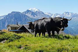
Je souhaite faire le tour des Combins avec mes 2 fils qui ont respectivement 22 et 19 ans. Personnellement j'ai 47 ans et n'ai plus trop le temps de faire du sport (sauf l'entretien d'un terrain de 1500 m, c'est pas rien ! ^^).
Nous aimons la rando mais ne sommes pas des experts de la montagne. Pour situer notre profil, nous avons traversé il y a quelques années la Corse d'Est en Ouest puis remonté au Nord avec nos sacs y compris portage de tente (rando de 3 semaines). Nous avons également eu l'occasion de faire quelques randos dans le massif central de quelques jours seulement. Concernant la montagne j'avais l'habitude jusqu'à mon adolescence de randonner en boucle autour d'un point d'attache dans les Alpes dans le massif du Mont-Blanc. J'ai gardé de cette époque le goût des espaces et des paysages d'altitude moyenne.
J'ai tout à fait conscience des dangers de la rando en montagne, que ce soit la méteo (surtout en fin d'été), la durée des étapes, les risques en dehors des chemins balisés, les risques de deshydratation...
Ceci étant dit, mes interrogations sur le Tour des Combins, portent surtout sur la divergence des avis que je peux lire ça et là sur le net, entre ceux qui le décrivent comme une course difficile (et peut-être dangereuse ?) et ceux qui la recommandent sans aucune mise en garde particulière. Voici donc mes questions, merci à ceux qui m'apporteront leurs lumières.Avons nous le niveau pour cette rando (après petite préparation, bien sûr) ? Les avis de Vic09 et de Simon m'interessent tout particulièrement...L'époque choisie (du 18 au 23 août) présente-t-elle des risques particuliers dans cette région précisément ?Est-il nécessaire de réserver (3 personnes) dans les cabannes à cette époque de l'année ? Est-il envisageable de planter une petite tente a proximité d'une cabanne pour une nuit (si cette dernière est full) ?Ce parcours comporte-t-il des passages délicats sur lesquels vous pourriez nous alerter ?Enfin, je ne souhaite pas avoir à utiliser 5 cartes complémentaires pour couvrir le parcours ; existe-t-il donc UNE carte qui couvre l'ensemble du tours ? au pire 2 (lesquelles s'il vous plait) ?Voilà, merci d'avance pour vos réponses :) Et bons plaisirs en montagne !
PS1 : Simon, bravo pour ton site qui est très intéressant et très bien réalisé. Les voyages que tu as choisis sont révélateurs je crois d'un esprit curieux, d'un besoin de liberté, d'une certaine forme d'humanisme et de convictions écologistes. Bonne route pour la suite !
PS2 : VIC09, tu sembles vouer une véritable admiration à ta région. Tu en parles bien et cela donne envie de venir y puiser un peu d'énergie !
PS1 : Simon, bravo pour ton site qui est très intéressant et très bien réalisé. Les voyages que tu as choisis sont révélateurs je crois d'un esprit curieux, d'un besoin de liberté, d'une certaine forme d'humanisme et de convictions écologistes. Bonne route pour la suite !
Hé, ca ne serait pas de la flatterie afin d'obtenir des réponses 😛 Je déconne, merci 🙂
Je suppose que tu as déjà dû lire ce poste ?
www.voyageforum.com/v.f?post=1950159#1950159
Comme je l'avais dit, je n'ai fait qu'une partie de ce tour, et c'était au milieu d'une longue marche. Difficile donc pour moi (je ne me souviens plus de tout) de te répondre plus en détaille que sur le poste précèdent (notamment pour les passages délicats)
Pour les nuits, si tu ne réserves pas les refuges, il est préférable (surtout en étant 3) de prendre une tente. Et aucun refuge qui serait complet ne te refusera que tu la plantes à côté.
Je serais très étonné qu'il n'existe pas une carte ou un topo (et pas 5 cartes) pour ce tour.
Oui Simon, j'ai lu ce post en effet. il contient déjà de nombreuses infos.
Hé, ca ne serait pas de la flatterie afin d'obtenir des réponses 😛 Je déconne, merci 🙂
Nan nan, c'est pas de la flatterie 😉 juste un avis sincère. J'ai même oublié de parler de la qualité des photos !
Sinon, j'avais une autre question un peu basique : savez-vous s'il est possible de payer en euros, de façon générale en Suisse, et plus particulièrement dans les cabanes du tour des Combins ? ça m'enlèverait une épine du pied 😎
Les Suisses ne sont pas du genre à refuser des sous 😄 Surtout les Euros, étant encerclé, ils n'ont pas trop le choix 🙂
Apres pour les cabanes hauts perchés, je ne sais pas, ca dépend du bon vouloir du gardien.
bonjour,
d'abord va sur le site www.tourdescombins.ch, car en Suisse nous sommes organisé. tu as le parcours complet avec toutes les cabanes. Je ne connais pas le coté italien mais parfaitement les cabanes en Suisse. Ensuite ne prends pas de tente (une abbération) c'est trop lourd et si il pleut... car en montagne il y a souvent des surprises. Pour les cabanes mentionnées, la plus belle (et le plus beau site) est Panossière aussi appelée F-X. Bagnoud. Brunet est pas terrible et mieux vaut réserver car quelquefois fermée.
Aucune difficulté majeure mais pour un non sportif il y a des étapes un peu longues. Attention à la fenètre Durand car le col est à 2800m d'altitude et cette année il y a énormément de neige. Tu peux passer sans crampons mais des batons de ski ou un piolet peux toujours aider.
Ah oui, tu as meilleurs temps de changer un peu de franc suisses, bien sûr qu'on te prendra tes euros, mais pas forcément à un cours terrible.
si tu as besoin d'autres infos je suis à ta dispo.
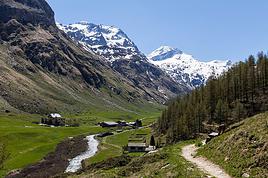
j'arrive du tour des combins voici mon expérience
nous sommes partis de glassier en italie (vallée de valpelline)
1° jour montée au refuge de champillon environ 900m de dénivelé durée 3h arrêts compris.refuge confortable deux douches 37€ /pers
2° jour Refuge champillon - hospice du grand st bernard 8h environ 900m de dénivelé
Hospice trés agréable avec douches. 33€/pers
3° jour Hospice du Gd st bernard -refuge du col des miles via Bourg st Pierre 1000 de dénivelé durée 9h arrêt compris .pas de douhe un robinet à l'extérieur.40€/pers
4° jour refuge col des miles -la panossiéres via le col des avouillions puis traversée du glacier de corbassiére.dénivelé de 800m durée 7h00 pas besoin de crampons .balisé par des piquets bleus.38€/pers trés bien
Du col des miles possibilité de réaliser la montée au Mont Rogneux .
5° jour refuge panossiére - refuge de chanrion passer par le barrage et le sentier en balcon audessus du lac- col de tsoferet trés belle vue sur le Gd combin .Il y a une variante avant d'arriver au lac qui passe par la côte 2442 m cela fait 300m de dénivelé en plus mais la vue est magnique .Le gardien de pannossiére peut vous donner des indications.pas de douche dénivelé 800m pour une durée de 8h30
6° jour refuge de chanrion - le glassier par la fenêtre durand .Monter au sommet du mont Avril si vous êtes en forme sente bien marquée .Magnifique vue sur les sommets suisse (Grd combin, mont rose , cervin, pignet d'arrola ........)
Pour ce qui est de la difficulté je ne peux pas te le dire chacun à son rythme son entrainement .Pour moi cela n'a pas présenté de difficulté particuliére.C'est la premiére fois que je faisais une rando itinérante de 6 jours.Je marche réguliérement en montagne 1à 2 week end par mois
Pour la tente je n'en ai pas vu
Je pense qu'il est préférable de résever si vous ne voulez pas faire un bivouac improvisé
Aucune difficulté particuliére , pas de danger les sentiers sont bien marqués.En Italie indication TDC (tour des combins) en suisse un losange jaune entouré d'un liseret noir.
La descente du col des autanes sur le lac peut être délicate par mauvais temps (pluie ou neige sentier glissant) Prendre des batons de rando par sécurité
Comme carte nous avions une carte au 50 000° du grand combin .
Voila les infos que je peux te donner .Rando magnifique surtout les deux dérniéres étapes
J'aimerai savoir si le tour des combins sont facile ou dificile pour des personnes de 21 a 22 ans pour leur premieres marche on sera 4 a 6 pour faire cette…
Avec un ami, nous avons décidé de nous lancer ce petit défi: partir la 2ème semaine de septembre pour une randonnée de +/- 6 jours. Ca serait une première pour…
J'envisage de faire le tour des Combins (rando) cette été. Pouvez-vous me dire si je dois réserver à l'avance pour les nuits dans les cabanes et refuges car…
Je viens de finir le tour des dents du midi, merci pour tous vos conseils! eh oui la deuxième gourde m'a vraiment servie!!!!:-) merci encore pour tout ces…
Quelle carte puis-je prendre pour faire le tour des combins et le tour des dents du midi? car il y a de nombreuses sujestions sur les différents sites de ces 2…
Bonjour,
Nous souhaitons faire le trek de 4 jours reliant Mestia à Ushguli sans agence. Il est précisé dans les descriptifs qu'il existe des hébergement à chaque étape, mais on ne trouve pas d'info sur ces hébergements. Quelqu'un a-t-il des infos et un avis sur ce parcours?
We're planning to trek in Peru and Bolivia and would love to find some local agencies.
If you know any, could you share details on prices and, of course, the names of the agencies?
Which trek would you recommend?
Elocine
Je pars en autonomie totale sur un trek au Maroc (10jrs) Imilchil - Aghbalou.
Trouve t-on des cartouches gaz à vis (Coleman, Primus) à Marrakech (adresse) ou villages entre Imilchil - Aghbalou ?
Si non , trouve-t-on des cartouches Butagaz pour camping-gaz (petit volume 230 gr ...)
Merci d' avance pour vos réponses
Hello, I’d like to embark on a little trip in my home country, Switzerland. I’ll start walking from La Cure, heading toward Le Noirmont first, then I’ll improvise my route—but it’ll probably follow the French border... at least as far as Lac de Joux.
I’ll decide day by day how much farther to go after that. My goal is to stay in nature as much as possible, wander around for as long as I can, and restock food in villages or towns along the way.
I’m thinking of mostly camping, but we’ll see if I end up in a hotel or another campsite depending on my route.
I’d love to reach La Chaux-de-Fonds on foot... maybe even Delémont.
The whole thing should take about a week, give or take.
I’ll be bringing my dog, and I’m preparing for this as soon as I’m ready.
Any tips to make sure everything goes smoothly for us? Things I should know—or avoid? What about shepherds with their flocks of sheep? And isn’t hunting season open right now?
I’m not sure if what I’m planning is even doable, which is why I’m asking around.
This’ll be my first time doing something like this—wandering in nature *and* with a dog. I’m really excited for this adventure... and I need it. Thanks!
We’re really keen on ecosystems and want to hike in "natural" ancient forests—not planted woods or areas heavily degraded by human activity. Travel guides (like Lonely Planet) don’t provide much info on this. Could you point us to the most interesting spots?
Thanks in advance for your tips.
We wish you happy holidays and a fantastic 2026, full of discoveries!
Claire and Albert
Hi, this might not be the right section, but I’d like to know if it’s possible to start mountaineering with another person without necessarily hiring a guide. We’ve done quite a bit of hiking but not mountaineering—we’ll just do a half-day glacier course. After that, we were thinking of starting with La Grande Motte and the Pointe de la Traversière, which were recommended to us. Honestly, for things like roping up and knots, I’ll learn at home with lots of videos and a book.
Hi,
I don’t know Switzerland at all and was wondering if Vallée des Joux and especially Dent de Vaulion are packed early in the morning or late in the afternoon in July and September?
If so, do you have any quieter spots to recommend in the area, or in Luxembourg (yes, I know it’s not the same country 😉)?
Thanks a lot!
Jaimerais savoir si quelqu'un aurait fait des treks sur le Ruwenzori et combien ça coute en moyenne, les infrastructures, les paysages la sécurité sur les lieux, merci beaucoup. J'attends avec impatience vos réponses.
We’re leaving in 9 days for a two-week trip to Madeira, mainly to hike.
From my research, I’ve found that since last year, access to most trails—and systematically for the most popular ones—is now paid. You have to pay an access fee of 4.50 € per person per classified hike in 2026, and even 10.50 € for the most iconic hike: Pico Arieiro to Pico Ruivo. When paying, you also have to choose a day and a 30-minute time slot for your start time. Of course, this reservation is neither changeable nor refundable, even if the weather that day is terrible.
Personally, given the massive influx of tourists to the island in recent years, I don’t mind paying a fee to help maintain the trails. Similarly, setting a limit on the number of people who can hike them per day is certainly preferable to preserve this priceless heritage.
However, what’s much less fair is that in reality, most of the available spots are reserved: 1/ for Madeira residents (which is normal); 2/ for "economic operators" (meaning local tour operators). For example, if you’re a non-resident (independent tourist), no booking is possible for the Pico Arieiro hike for an early morning start before September! So, unfortunately, we’ll have to skip this hike.
It’s the same issue for Ponta de São Lourenço, the 25 Fontes, Pico Ruivo... in short, all the most popular hikes. Oh well, we’ll skip those too!
So my question is: which hikes do you recommend where we won’t face the huge crowds that the others get? And where we can book the day before for the next day, taking the weather into account?
Finally, a quick accommodation question: we’ve booked the first week in Funchal, but I haven’t decided yet for the second week. Do you have any advice on where to stay in the south or north, preferably avoiding overly concrete-heavy and touristy spots?
I’m reposting about the logistics for Samaria Gorge.
I’d love to get recent info, especially about whether it’s possible to park my car in Omalos, do the hike, and then catch a bus back to my vehicle.
In theory, it’s doable, but when you check the KTEL website, there aren’t any feasible schedules listed. If anyone has recently organized this with reliable, verified details, I’d really appreciate it. Thanks in advance!
Hi there,
We’re flying from Montreal to Lyon this August to go hiking in the French Alps. We’ve rented a car and will be staying at campgrounds. We’re planning to do day hikes and want to stay a few days in one spot, do a few hikes, then move on to our next camping spot. Could you share your favorite spots or any recommendations for places to spend a few days with great hikes?
A few details:
We arrive in early August and leave in early September.
We’re looking for day hikes (or shorter), moderate difficulty, with a cumulative elevation gain of no more than 1000m, and of course, beautiful scenery!
We’d prefer not to drive too much—maybe it’s best not to head too far south and deal with unnecessary heat?
Along the same lines, if you know of any great campgrounds where we can start our hike directly without needing the car, we’d love to hear your suggestions!
Bonjour
Souhaitant faire de la randonnée sur cette île, je voudrais d'abord savoir quelle serait la période la plus favorable sachant que j'avais passé quelques jours en novembre 2018 pas pour cette activité mais plus pour une simple découverte de l'île et le temps n'était pas top notamment en montagne. Donc peut on choisir une organisation en étoile sachant que je louerai un véhicule avec éventuellement 2 points d'hébergement.
Je n'envisage pas d'intégrer une structure mais de partir à 2 et de s'organiser sauf si vous me conseillez une agence locale ou un guide local. Enfin même si je compte me procurer les différents supports, carte et topo guide plus gps je vous remercie de bien vouloir me communiquer les randos à faire en priorité
Merci beaucoup pour vos informations
I’m planning to do the Mercantour crossing following the Randoxygène route in mid-July.
I’m used to hiking in the mountains, but I sometimes get vertigo, for example on ridges with drops on both sides. I wanted to check if there are any T4 or T3-T4 sections and find out if there are any very exposed passages—and if so, where—so I can plan an alternative route.
Can anyone give me some info on this?
Thanks!
I’m planning a trip around Cap Corse and the AGRIATES in 2026, from May 8th to 15th (there are still 2 spots left, by the way! Just DM me if you're interested).
I’d love to know which hikes are worth prioritizing in the AGRIATES. We’ll be staying in SALECCIA for two days as our base—what should we focus on from there?
A round trip to IGNHU beach? Any other suggestions?
For Ostricano, I think it’s too far for a round trip...
Thanks for your tips!
Have a great day,
Anie, Toulouse
I’d like to get some info about the GR10 Pyrenees traverse. I need help planning the daily stages and accommodations—my wife isn’t an experienced hiker but walks a lot, so I’d like to schedule shorter walking days and thus a longer overall trip in terms of number of days.
Could anyone give me some help and advice?
Best regards,
New to this forum, I’m planning a pretty big project for 2028.
I’m heading to Nepal to do a trek from Kathmandu all the way to Everest Base Camp (a cool 5,300 m 😄).
This trek is a bit special because even though I’ll be part of a group, I’m going solo (so far, no problem—I’m used to it). But it’s my first real trek, and it’s also a humanitarian one: once I reach base camp, I’ll stay an extra week to help clean up the waste left by tens of thousands of climbers! Since I’m originally from South America, from two countries that share the Andes, I have a deep respect for mountains—they fascinate me. So Everest… it’s kind of the trip of a lifetime!
So, a little question for those who’ve done treks to Everest before… any tips for good mental preparation (I’m already working on the physical side)?
Hi there, I’m planning the Annapurna Circuit for March 2027 and I’m looking for a local agency with a local guide—preferably French-speaking—to arrange this trek for us. Any suggestions? Thanks
Hello!
We’re spending a few days in Toraja country at the end of May. We’d love to do a day trek—taking our time—on a route that’s stunning in terms of scenery, but not a level 5 in difficulty!
Any suggestions you can share, please?
Thanks in advance
I’d like to do the Mare a Mare Sud in May over 4 days. I’ve found quite a few places to stay along the route, but I’m stuck on the start and finish.
I’ll be arriving by plane on Sunday evening and would like to start pretty early on Monday morning. Ideally, accommodation right at the trailhead (Alzu di Gallina) would be amazing, but I can’t find anything. Any tips?
Also, for the transfer from Figari Airport to Porto Vecchio or Alzu di Gallina?
At the end, I’d like to pick up a rental car—any advice on that too?
I’m traveling solo by plane to Catania in May and plan to hike the northern side of Etna, starting from Linguaglossa where I’ll arrive by bus. After that, I’d love some info on how to get up to Piano Provenzana (shuttles or hitchhiking), since it seems there’s no public transport except in the summer. Can you sleep there in a free or cheap refuge, or camp? And how far up can you go without having to hire a guide? Thanks in advance. Bernard.
Bonjour a tous,
je pars en voyage au Maroc en aout et nous allons commencer par nous arrêter a Chefchaouen(nous sommes en voiture).
Ma question: quelqu'un peut il m'indiquer un itinéraire de rando en boucle d'entre 5 et 7 jours aux départ de Chefchaouen dans le parc de Talassemtane passant si possible par le pont de dieux?Ou un guide papier qui en reunis quelques uns?
Nous privilégions le camping sauvage et les gites.
Merci d'avance
Hi there, for those who’ve been recently—is it possible to find other solo travelers in March on the island to share transport or room costs? It doesn’t seem easy to travel on a budget.
If you have any recommendations for simple lodgings or places with dorms, I’d love to hear them.
For those who’ve done multi-day treks while moving around: do you need to bring your own sleeping bag? I’d love to hear about itineraries you’ve done without a guide, just with a map and GPS.
Thanks, and have a great day!
Hi everyone!
We’re planning a 15-day road trip to Scotland this summer, specifically to explore and hike on Lewis and Harris—places we’ve never been before. We’ve visited other islands on previous road trips in Scotland (we usually go in April for a week). This would be our first time in Scotland in the summer and for 15 days. We’re looking at late August to early September.
I’m currently drafting the itinerary. We’d be crossing from Ullapool and were thinking of spending 3 nights on Harris and 4 nights on Lewis.
Does that sound balanced to you? Is it better to keep the same accommodation on Harris and the same on Lewis to explore the area? I’d love to hear about any past experiences you’ve had on these islands.
Thanks!
Hi there, I’m trying to leave for 15 days very soon to São Vicente. I’m either looking to join an agency or figure things out on my own to go hiking on one of these islands or both. From what I’ve seen, it’s not easy to organize with local transport, so it gets expensive. Can I use the services of a small local agency? I’m looking for the simplest way to hike for several days. Also, how do you get from São Vicente to São Nicolau? Thanks in advance and have a great day!
Aichatou
I’ve been wanting to do this for several years, and this year’s the one. Next September, I’ll be trekking in Tusheti (Georgia), from Omalo to Shatili.
Of course, I won’t be renting a vehicle that’d just sit unused. No problem getting to Pshaveli, but from there to Omalo, it’s a dirt road (still the case?)
There must be some form of public transport since there are so many guesthouses, and not all travelers come in a 4x4.
If any of you have been to Omalo, could you confirm that these shared transports exist and how often they run?
we’re planning a trip to Yellowstone and hoping to do a three-day backcountry hike if we get a permit.
if any of you have done this before, could you let me know if it’s possible to find water along the way? And if we can transport it, are we allowed to use a stove?
Hello,
I’ll be in Nepal from March 6th to 29th (we’re flying into Kathmandu via Varanasi and leaving via Delhi).
I’m a bit confused about the regulations requiring a guide.
My wife and I (we’re 63 and 64) aren’t experienced trekkers—we’re more used to walking on terrain with very moderate elevation changes. I’m looking for fairly easy hikes, possibly day trips.
Here are my questions:
- Does the Poon Hill trek from Pokhara require a guide, or is it better to go through a local agency? (I’ve seen a lot of them offering 4-day packages)
- I’d like to do a few multi-day hikes around Jomsom (Kagbeni, Mukitinath, Lupra, Marpha)... Do you need a guide for those, and can you find accommodations easily without booking in advance?
Last question—I’m really hesitant to lug around a sleeping bag or down jacket during our 6 weeks in India. Can you easily find these kinds of items at reasonable prices in Pokhara?
Thanks in advance for any tips you can share!
Yann