j'ai prévu de partir en février 8 jour pour un trek à pieds avec terre d'aventure...voilà le programme :
c'est mon premier trek et s'il y a des connaisseurs, merci pour leur avis sur le circuit et le climat à cette époque. tout le monde me dit que je vais me geler...la nuit. tous les conseils seront le bienvenus
merci d'avance
J1 : Vol Paris/Ouarzazate. Transfert à l´hôtel.
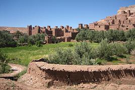
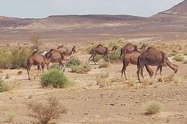
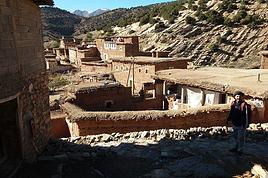
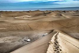
J2 : Départ pour la vallée du Drâa et son long ruban de palmiers qui s´étire sur 200 km. Passant par Agdz, Zagora et Taggounit, nous arrivons à Ouled Driss dans la palmeraie de M´Hamid. Chargement de nos chameaux de bât et début de la randonnée entre cultures et palmiers. Bivouac après M´Hamid El Rhozlane. 3h de Marche.
J3 : Les falaises de la hamada du Drâa au sud, nous progressons au rythme de nos chameaux en direction du premier erg d´Aït Oumir. Quelques tamaris nous procurent un peu d'ombre avant le bivouac… 6h de marche.
J4 : Toujours en rive gauche de l´oued asséché du Drâa, nous prenons les hautes dunes de l´erg Zaher pour repère. Bivouac au pied des dunes. 5h30 de marche.
J5 : Plein nord, pour traverser le lit du Drâa et déjeuner à l´ombre de l'arbre de Sidi Taïb. Bivouac entre les ergs de Sedrar et Smar. 5h de marche.
J6 : Les reliefs de la hamada du Drâa s´estompent dans les brumes de chaleur, tandis que la barrière noire du djebel Bani se précise. Laissant l´oued El Attach (la rivière de la soif), nous rejoignons notre dernier bivouac à l´erg Bouguern. 5h30 de marche.
J7 : Après 1h de marche, c´est le point de rendez–vous avec les véhicules tout–terrain. Déjeuner pique–nique à Zagora. Continuation sur Ouarzazate que nous atteignons en fin d´après–midi. Dîner et nuit à l´hôtel.
J8 : Transfert à l´aéroport et vol pour Paris.
Bonjour,
Cest une boucle et vous allez tourner autour de M'hamid.
Le mieux est de continuer vers lac iriki et rentrer par foum zguite et taznakhte. Ce retour demande un transfert en 4/4. les agence préfèrent les transferts en minibus pour y mettre plus de monde et faire du bénifice.
Bon trek quand même.
j'ai vu que c'était une boucle merci.....c'est un circuit défini.....et puis j'ai surtout envie de découvrir le désert.......mais au niveau des températures à cette saison, tu peux me renseigner ?
Que le dharma soit avec toi
Bonjour,
C'est comme tous les produits de terre d'av, un bon moyen d'approcher ce désert, et, de plus, adapté à la saison (sauf dérèglement climatique ou situation exceptionnelle), tout juste frais la nuit et tee shirt entre 11 h et 16h.
Suis les conseils de la fiche technique, en général, rien à rajouter.
C'est ce que j'avais supposé au feeling...donc je vais réserver.....
je te souhaite une merveilleuse année 2009....je te recontacterais pour te faire part des mes impressions à mon retour....
Nous avons fait ce trek à la même période avec un groupe d'une vingtaine de retraités bons marcheurs. Nous en avons de très bons souvenirs. Il faut prévoir un duvet moins cinq comme le préconise terre d'Av. Il n'a gelé qu'une fois pendant une nuit mais nous dormons en tentes igloo deux places.
Bien suivre les conseils de Terre d'Av concernant le matériel à emporter. Ne pas trop se charger, ce sont les chameaux qui portent les sacs.
Les guides formés par terre d'Av sont très sympas et compétents ainsi que les chameliers et le cuisinier.
On marche six à sept heures par jour sans difficultés aucune, sur des regs champs de cailloux plats et on traverse des dunes.
Pendant la journée il fait doux, il peut y avoir du vent, prévoir l'achat d'un chech sur la route entre Ouarzazate et M'Hamid (pas au village artisanal de Ouarzazate où je me suis fait escroquer).
Je recommande,
BONSOIR
RIEN A CRAINDRE AVEC TERDAV, BIEN ORGANISE, SOUVENT PETIT GROUPE BIEN SYMPA
AI FAIS LA VALLEE DU DADES, OUARZAZATE DEBUT MARS :SUPER CLIMAT
BON VOYAGE
en février, il fait bon (parfois même un peu frais) la plus grande partie de la journée, chaud (mais du chaud plus que supportable entre 12 et 15 h), et bien frais la nuit.
Pour ton circuit, je ne connais pas tout. Mais l'oued El Attach et l'erg Bougern sont les endroits que j'ai préférés dans le trek que j'ai fait dans la région. C'est juste magnifique.
bonjour a vous .
comment allez vous. j'espere que tu te porte bien je suis un jeune homme du sud marocain; Mhamid le vrai porter du desert je peux te donner toutes les information sur le sud du maroc si tu veux je suis né au desert et je le connai bien
le climat vraiment superb la journeé un tres belle soleil la nuit un peu froid
Bonsoir Nanaty,
J'ai fait un trek similaire voici 2 ans en février, il faisait très chaud pendant la journée (ne pas oublier la crème solaire), les nuits étaient fraiches mais non glaciales (avec mon sac de couchage en plume, j'ai dormi à la belle étoile)...
Mon conseil : avoir un sac de couchage confortable et une bonne polaire.
C'est un très beau circuit, dont je garde un excellent souvenir.
Une astuce pour l'eau : en + de micropur, j'ai ajouté qq gouttes d'extrait de pépin de pamplemousse, je n'ai eu aucun problème
d'intestin.
Pour la toilette, j'ai acheté des gants pré-imbibés 2 faces en magasin de sport.
A ta disposition pour d'autres renseignements - Bon trek - Anne-Marie de Blois (Loir-et-Cher)
Etant libre tous le mois d'avril, je désirais faire un treck dans l'Atlas, plutôt style sportif en autonomie complète, tente/sac à dos/carte etc... Je voudrais…
En général, lorsque je part en trek (Népal, érou, inde, etc...), je me pointe sur place et il est souvent possible de partir dès le lendemain avec un guide. Je…
Je veux faire une partie de la traversée de l'Atlas marocain au mois d'aout 2008 avec un ami et je cherche des infos sur ce trek. est-il possible de le faire…
Je cherche à organiser une rando d'1 sem début juin dans le massif du M'Goun en direct avec un guide. J'ai trouvé sur des forums de montage un guide de Taban…
Bonjour,
Nous souhaitons faire le trek de 4 jours reliant Mestia à Ushguli sans agence. Il est précisé dans les descriptifs qu'il existe des hébergement à chaque étape, mais on ne trouve pas d'info sur ces hébergements. Quelqu'un a-t-il des infos et un avis sur ce parcours?
We're planning to trek in Peru and Bolivia and would love to find some local agencies.
If you know any, could you share details on prices and, of course, the names of the agencies?
Which trek would you recommend?
Elocine
Je pars en autonomie totale sur un trek au Maroc (10jrs) Imilchil - Aghbalou.
Trouve t-on des cartouches gaz à vis (Coleman, Primus) à Marrakech (adresse) ou villages entre Imilchil - Aghbalou ?
Si non , trouve-t-on des cartouches Butagaz pour camping-gaz (petit volume 230 gr ...)
Merci d' avance pour vos réponses
Hello, I’d like to embark on a little trip in my home country, Switzerland. I’ll start walking from La Cure, heading toward Le Noirmont first, then I’ll improvise my route—but it’ll probably follow the French border... at least as far as Lac de Joux.
I’ll decide day by day how much farther to go after that. My goal is to stay in nature as much as possible, wander around for as long as I can, and restock food in villages or towns along the way.
I’m thinking of mostly camping, but we’ll see if I end up in a hotel or another campsite depending on my route.
I’d love to reach La Chaux-de-Fonds on foot... maybe even Delémont.
The whole thing should take about a week, give or take.
I’ll be bringing my dog, and I’m preparing for this as soon as I’m ready.
Any tips to make sure everything goes smoothly for us? Things I should know—or avoid? What about shepherds with their flocks of sheep? And isn’t hunting season open right now?
I’m not sure if what I’m planning is even doable, which is why I’m asking around.
This’ll be my first time doing something like this—wandering in nature *and* with a dog. I’m really excited for this adventure... and I need it. Thanks!
We’re really keen on ecosystems and want to hike in "natural" ancient forests—not planted woods or areas heavily degraded by human activity. Travel guides (like Lonely Planet) don’t provide much info on this. Could you point us to the most interesting spots?
Thanks in advance for your tips.
We wish you happy holidays and a fantastic 2026, full of discoveries!
Claire and Albert
Hi, this might not be the right section, but I’d like to know if it’s possible to start mountaineering with another person without necessarily hiring a guide. We’ve done quite a bit of hiking but not mountaineering—we’ll just do a half-day glacier course. After that, we were thinking of starting with La Grande Motte and the Pointe de la Traversière, which were recommended to us. Honestly, for things like roping up and knots, I’ll learn at home with lots of videos and a book.
Hi,
I don’t know Switzerland at all and was wondering if Vallée des Joux and especially Dent de Vaulion are packed early in the morning or late in the afternoon in July and September?
If so, do you have any quieter spots to recommend in the area, or in Luxembourg (yes, I know it’s not the same country 😉)?
Thanks a lot!
I’m starting this thread—lots of travelers here have done this trek.
When RMS is mentioned, it’s this agency: Ruwenzori Mountaineering Services (with an *s*), because there’s another one online called Ruwenzori Mountaineering Service (no *s*).
Their site:
www.rwenzorimountaineeringservices.com/
From what I gather, it’s the local mountain guide agency certified by the government?
Jaimerais savoir si quelqu'un aurait fait des treks sur le Ruwenzori et combien ça coute en moyenne, les infrastructures, les paysages la sécurité sur les lieux, merci beaucoup. J'attends avec impatience vos réponses.
We’re leaving in 9 days for a two-week trip to Madeira, mainly to hike.
From my research, I’ve found that since last year, access to most trails—and systematically for the most popular ones—is now paid. You have to pay an access fee of 4.50 € per person per classified hike in 2026, and even 10.50 € for the most iconic hike: Pico Arieiro to Pico Ruivo. When paying, you also have to choose a day and a 30-minute time slot for your start time. Of course, this reservation is neither changeable nor refundable, even if the weather that day is terrible.
Personally, given the massive influx of tourists to the island in recent years, I don’t mind paying a fee to help maintain the trails. Similarly, setting a limit on the number of people who can hike them per day is certainly preferable to preserve this priceless heritage.
However, what’s much less fair is that in reality, most of the available spots are reserved: 1/ for Madeira residents (which is normal); 2/ for "economic operators" (meaning local tour operators). For example, if you’re a non-resident (independent tourist), no booking is possible for the Pico Arieiro hike for an early morning start before September! So, unfortunately, we’ll have to skip this hike.
It’s the same issue for Ponta de São Lourenço, the 25 Fontes, Pico Ruivo... in short, all the most popular hikes. Oh well, we’ll skip those too!
So my question is: which hikes do you recommend where we won’t face the huge crowds that the others get? And where we can book the day before for the next day, taking the weather into account?
Finally, a quick accommodation question: we’ve booked the first week in Funchal, but I haven’t decided yet for the second week. Do you have any advice on where to stay in the south or north, preferably avoiding overly concrete-heavy and touristy spots?
I’m reposting about the logistics for Samaria Gorge.
I’d love to get recent info, especially about whether it’s possible to park my car in Omalos, do the hike, and then catch a bus back to my vehicle.
In theory, it’s doable, but when you check the KTEL website, there aren’t any feasible schedules listed. If anyone has recently organized this with reliable, verified details, I’d really appreciate it. Thanks in advance!
Hi there,
We’re flying from Montreal to Lyon this August to go hiking in the French Alps. We’ve rented a car and will be staying at campgrounds. We’re planning to do day hikes and want to stay a few days in one spot, do a few hikes, then move on to our next camping spot. Could you share your favorite spots or any recommendations for places to spend a few days with great hikes?
A few details:
We arrive in early August and leave in early September.
We’re looking for day hikes (or shorter), moderate difficulty, with a cumulative elevation gain of no more than 1000m, and of course, beautiful scenery!
We’d prefer not to drive too much—maybe it’s best not to head too far south and deal with unnecessary heat?
Along the same lines, if you know of any great campgrounds where we can start our hike directly without needing the car, we’d love to hear your suggestions!
Bonjour
Souhaitant faire de la randonnée sur cette île, je voudrais d'abord savoir quelle serait la période la plus favorable sachant que j'avais passé quelques jours en novembre 2018 pas pour cette activité mais plus pour une simple découverte de l'île et le temps n'était pas top notamment en montagne. Donc peut on choisir une organisation en étoile sachant que je louerai un véhicule avec éventuellement 2 points d'hébergement.
Je n'envisage pas d'intégrer une structure mais de partir à 2 et de s'organiser sauf si vous me conseillez une agence locale ou un guide local. Enfin même si je compte me procurer les différents supports, carte et topo guide plus gps je vous remercie de bien vouloir me communiquer les randos à faire en priorité
Merci beaucoup pour vos informations
I’m planning to do the Mercantour crossing following the Randoxygène route in mid-July.
I’m used to hiking in the mountains, but I sometimes get vertigo, for example on ridges with drops on both sides. I wanted to check if there are any T4 or T3-T4 sections and find out if there are any very exposed passages—and if so, where—so I can plan an alternative route.
Can anyone give me some info on this?
Thanks!
I’m planning a trip around Cap Corse and the AGRIATES in 2026, from May 8th to 15th (there are still 2 spots left, by the way! Just DM me if you're interested).
I’d love to know which hikes are worth prioritizing in the AGRIATES. We’ll be staying in SALECCIA for two days as our base—what should we focus on from there?
A round trip to IGNHU beach? Any other suggestions?
For Ostricano, I think it’s too far for a round trip...
Thanks for your tips!
Have a great day,
Anie, Toulouse
I’d like to get some info about the GR10 Pyrenees traverse. I need help planning the daily stages and accommodations—my wife isn’t an experienced hiker but walks a lot, so I’d like to schedule shorter walking days and thus a longer overall trip in terms of number of days.
Could anyone give me some help and advice?
Best regards,
New to this forum, I’m planning a pretty big project for 2028.
I’m heading to Nepal to do a trek from Kathmandu all the way to Everest Base Camp (a cool 5,300 m 😄).
This trek is a bit special because even though I’ll be part of a group, I’m going solo (so far, no problem—I’m used to it). But it’s my first real trek, and it’s also a humanitarian one: once I reach base camp, I’ll stay an extra week to help clean up the waste left by tens of thousands of climbers! Since I’m originally from South America, from two countries that share the Andes, I have a deep respect for mountains—they fascinate me. So Everest… it’s kind of the trip of a lifetime!
So, a little question for those who’ve done treks to Everest before… any tips for good mental preparation (I’m already working on the physical side)?
Hi there, I’m planning the Annapurna Circuit for March 2027 and I’m looking for a local agency with a local guide—preferably French-speaking—to arrange this trek for us. Any suggestions? Thanks
Hello!
We’re spending a few days in Toraja country at the end of May. We’d love to do a day trek—taking our time—on a route that’s stunning in terms of scenery, but not a level 5 in difficulty!
Any suggestions you can share, please?
Thanks in advance
I’d like to do the Mare a Mare Sud in May over 4 days. I’ve found quite a few places to stay along the route, but I’m stuck on the start and finish.
I’ll be arriving by plane on Sunday evening and would like to start pretty early on Monday morning. Ideally, accommodation right at the trailhead (Alzu di Gallina) would be amazing, but I can’t find anything. Any tips?
Also, for the transfer from Figari Airport to Porto Vecchio or Alzu di Gallina?
At the end, I’d like to pick up a rental car—any advice on that too?
I’m traveling solo by plane to Catania in May and plan to hike the northern side of Etna, starting from Linguaglossa where I’ll arrive by bus. After that, I’d love some info on how to get up to Piano Provenzana (shuttles or hitchhiking), since it seems there’s no public transport except in the summer. Can you sleep there in a free or cheap refuge, or camp? And how far up can you go without having to hire a guide? Thanks in advance. Bernard.
Bonjour a tous,
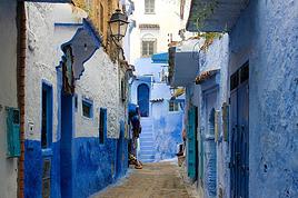
je pars en voyage au Maroc en aout et nous allons commencer par nous arrêter a Chefchaouen(nous sommes en voiture).
Ma question: quelqu'un peut il m'indiquer un itinéraire de rando en boucle d'entre 5 et 7 jours aux départ de Chefchaouen dans le parc de Talassemtane passant si possible par le pont de dieux?Ou un guide papier qui en reunis quelques uns?
Nous privilégions le camping sauvage et les gites.
Merci d'avance
Hi there, for those who’ve been recently—is it possible to find other solo travelers in March on the island to share transport or room costs? It doesn’t seem easy to travel on a budget.
If you have any recommendations for simple lodgings or places with dorms, I’d love to hear them.
For those who’ve done multi-day treks while moving around: do you need to bring your own sleeping bag? I’d love to hear about itineraries you’ve done without a guide, just with a map and GPS.
Thanks, and have a great day!
Hi everyone!
We’re planning a 15-day road trip to Scotland this summer, specifically to explore and hike on Lewis and Harris—places we’ve never been before. We’ve visited other islands on previous road trips in Scotland (we usually go in April for a week). This would be our first time in Scotland in the summer and for 15 days. We’re looking at late August to early September.
I’m currently drafting the itinerary. We’d be crossing from Ullapool and were thinking of spending 3 nights on Harris and 4 nights on Lewis.
Does that sound balanced to you? Is it better to keep the same accommodation on Harris and the same on Lewis to explore the area? I’d love to hear about any past experiences you’ve had on these islands.
Thanks!
Hi there, I’m trying to leave for 15 days very soon to São Vicente. I’m either looking to join an agency or figure things out on my own to go hiking on one of these islands or both. From what I’ve seen, it’s not easy to organize with local transport, so it gets expensive. Can I use the services of a small local agency? I’m looking for the simplest way to hike for several days. Also, how do you get from São Vicente to São Nicolau? Thanks in advance and have a great day!
Aichatou
I’ve been wanting to do this for several years, and this year’s the one. Next September, I’ll be trekking in Tusheti (Georgia), from Omalo to Shatili.
Of course, I won’t be renting a vehicle that’d just sit unused. No problem getting to Pshaveli, but from there to Omalo, it’s a dirt road (still the case?)
There must be some form of public transport since there are so many guesthouses, and not all travelers come in a 4x4.
If any of you have been to Omalo, could you confirm that these shared transports exist and how often they run?
we’re planning a trip to Yellowstone and hoping to do a three-day backcountry hike if we get a permit.
if any of you have done this before, could you let me know if it’s possible to find water along the way? And if we can transport it, are we allowed to use a stove?