Je suis passé à l'office du tourisme à pasto (2500 M) , pour avoir des infos. 2 possibilités :
Du centre , bus C7 jusqu'à San juan de Anganoy ( à peine 20mn ) et marcher jusqu'au Sanctuaire de flores y faunas( env 2h30).
Ou alors bus jusqu'à Yacuanquer, et trouvé un transport jusqu'à l'entre du parc" El galeras". Mais là il faut tel la veille car on monte jusqu'au mirador avec guide obligatoire . On est loin du volcan depuis le mirador.
J'ai opté pour la 1er .
J'y allais sans conviction car je n'avais pas beaucoup d'infos precises.
Sur Mapsme le sentier de rando y est . Le type de l'office du tourisme m'avait fait comprendre que l'on pouvait aller en clandestin... Bref .
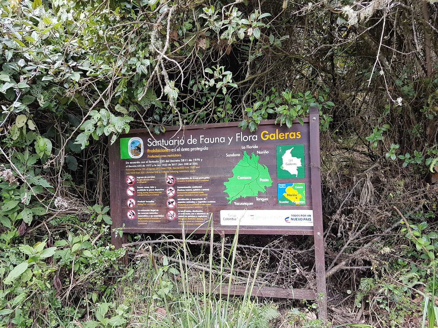
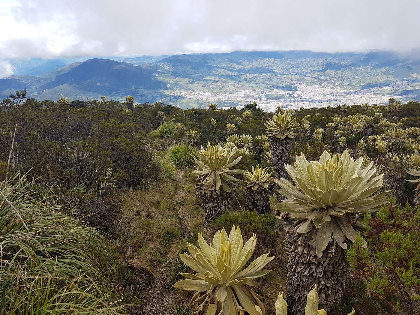
Le lendemain début de rando 8h15 , là où le bus s'arrête à 2800m daltitude. 1h de marche jusqu'à ce que je croise un moto taxi qui descendait. Je l'attrape et lui demande s'il pouvait me monté jusqu'à l'entrée du sanctuaire...pour 1euro. Il m'a soulagé d'une bonne heure de marche minimum, j'étais content.il s'est arrêté un peu avant les antennes car sa faisait loin pour 1 euro.....mais bon. Il me restait à peine 20mn à pied jusqu'au Sanctuaire . Avant la moto j'avais tenté le stop mais ils ne ce sont pas arrêté. J'arrive donc, portail fermé. Le fameux type qui ne m'avait pas pris était là, il accompagnait un technicien car il y a des grandes antennes de communication . Il me dit que je peux sauter le portail , comme il n'y avait personne ....
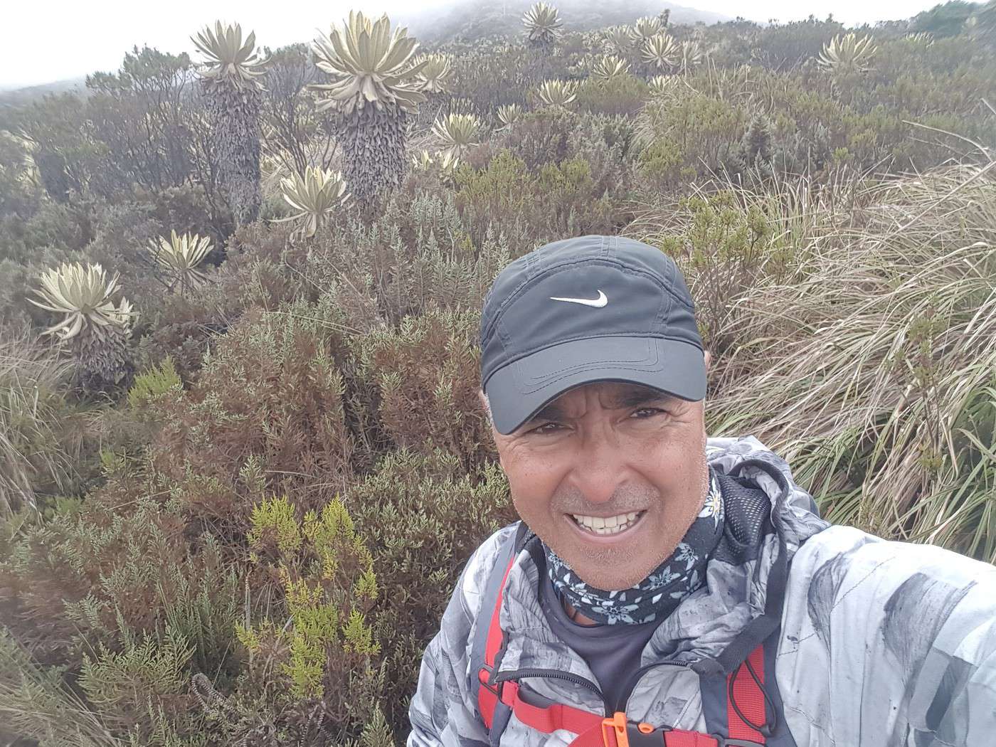
J'inspecte Les lieux et je trouve le début du sentier qui monte au volcan...jonché d'herbes hautes et branchages de toutes sorte qui obstruaient le sentier , plus grand monde passe par là, mais le sentier et tracé au sol, la terre est applati et il n'y a pas d'herbes qui pousse .J'ai pas mal hésité mais je m'y suis engagé, non sans difficulté. Ce qui me rassurait vraiment tout le long c'est qu'on ne pouvait pas se perdre ( en plus avec mapsme ). Il y a une piste de 4x4 qui part du sanctuaire. Franchement j'ai failli renoncer plusieurs fois...
Très difficile le passage et il fallait avoir un morale d'acier. J'ai mis 2h jusqu'à la piste à 3900m d''alti, cette fameuse piste que j'avais vu au depart. j'ai eu droit à la pluie en montant, un coup de plus au morale...
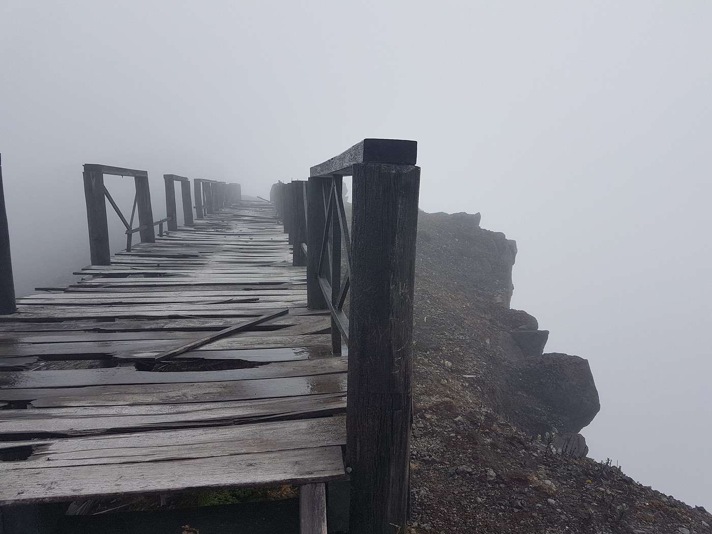
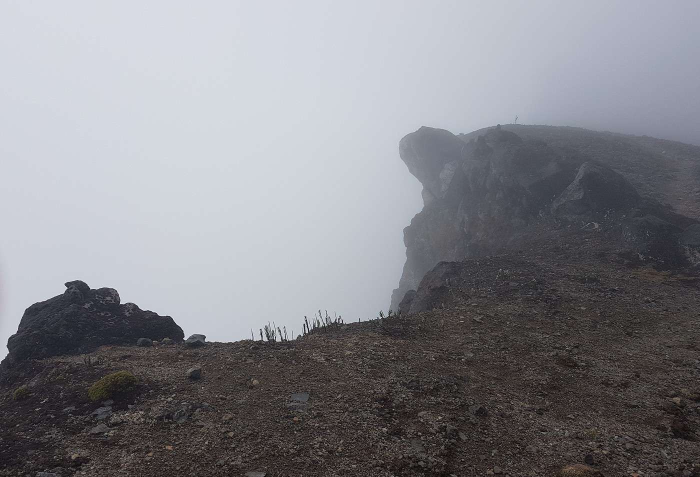
Ce sentier en faite, traverse la piste des 4x4, mais ça monte raide . Je reviens sur la piste et je me dit comme ça que s'il y a cette piste , ca va forcément quelque part. ...mais où et jusqu'où ?!.le volcan culmine à 4250m, forcément Il ne restait plus grand chose . j'avais un oeil sur la montre car il fallait pensé au retour avant la nuit .Mes calcules étaient bons. En faite cette piste monte jusqu'au cratère .Je ne voyais pas le sommet depuis belle lurette car il était dans le brouillard. ..un coup supplémentaire au morale....sur cette dernière heure j'avais pensé renoncer , je scrutais en permanace mon GPS , l'heure et l'altitude. Puis , un moment donné, je distinguais vaguement quelques chose sans savoir ce que c'était, je pensais à des appareilles de surveillance du volcan, hé bien non, c'était une plateforme en bois, plus que douteuse, pour observer le cratère. ...un mirador . Mais comme je venais de faire un magnifique hold-up, j'ai été puni . On ne voyait ABSOLUMENT RIEN car tout était dans le brouillard!. Forcément déçu mais aucun regret . Je suis resté à peine 5mn en haut, il y avait du vent, la pluie en revanche faiblissait .J'etais arrivé je pense sur un des flancs les plus bas du cratère car j'étais a 4173m alors qu'il est donné pour 4250m.
Pour redescendre jusqu'à l'entre du sanctuaire j'ai mis 1h40, par le même sentier infernale de branches, herbes hautes...mais le soleil revenait timidement, alors que le sommet était toujours dans le brouillard.
Au bout d'une heure de marche ( j'étais crevé ) je tombe sur une moto qui descendait, il m'a pris sans problème, j'étais HYPER content car il venait de me soulagé de 45mn de marche jusqu'au bus.
En faite, après analyse, l'idéal c'était de prendre un taxi jusqu'au sanctuaire et de négocier avec lui une heure pour venir me cherché. Pas facile quand on a aucune infos sur le temps qu'il faut pour monter à pied jusquau cratere, et surtout si c'etait autorisé...
J'ai commencé à 8h15 pour finir à 15h55 ce qui fait 8h10 de trek en tout.
J'ai la certitude que c'est réalisable en louant une moto car la piste monte jusqu'au cratère, mais le souci est de savoir s'ils laissent passer les gents....je ne le saurai jamais car il n'y avait personne ce jour là ...
Cetait le 30 Mai . Le 12 juin il y a eu un tremblement de terre ( 4, 5 sur rischter)à Pasto , qui a fait 2 morts ( chuttes de pierres dans une carrière visiblement) ça à détruit quelques maisons tout de meme, ils ont fermé les écoles. L'épicentre était situé sous le volcan.
Merci pour ces précisions. Il faut savoir que ce coin du Monde est un des plus arrosés de la planète et voir le cratère dégagé est un petit miracle. J'ai moi même monté le volcan Cumbal et météo exécrable avec 40 cm de boue dans la descente un régal ! Le sud de la Colombie pour voir le soleil c'est chaud !
"Certes, un rêve de beignet, c'est un rêve, pas un beignet. Mais un rêve de voyage, c'est déjà un voyage". Marek Halter
« Les montagnes sont des géants assoupis. (...) Peut-être que nous ne sommes que leur rêve, un rêve de la terre somnolente » Théodore Roszak
Oui salut! Merci pour le contacte!
Il est où le volcan cumbal?. Il est réalisable seul?. C'est vrai que le sud de la colombie est formidable!!!
Merci et bon trek!!!.
Patrick.
Frontière Equateur Colombie contrôle à l'époque par les Farc. Mieux vaut prendre un guide ce n'est pas techniquement difficile mais l'altitude peut jouer des tours et surtout la météo change à une vitesse record donc on se perds facilement ! Je rêve de voir cette région avec du soleil mais c'est très proche de l'équateur ! des tempêtes peuvent survenir en un temps record et le vent y est très fort.
"Certes, un rêve de beignet, c'est un rêve, pas un beignet. Mais un rêve de voyage, c'est déjà un voyage". Marek Halter
« Les montagnes sont des géants assoupis. (...) Peut-être que nous ne sommes que leur rêve, un rêve de la terre somnolente » Théodore Roszak
Je fais appel à vos connaissances sur ce beau pays qu'est la Colombie car j'ai décidé de m'y rendre au mois d'Aout. Alors voilà, mon idée de départ serait de…
Je pars en Colombie en décembre pour 3 semaines et j'aimerais beaucoup faire un trek... Le problème, c'est que ca n'a pas l'air folichon la Colombie pour…
Nous partons cet été en famille avec 3 ados dans le Nord de la Colombie et souhaitons réaliser un treck de 2 jours. Nous avons eu une proposition de l'agence…
Je pars prochainement en Colombie et j'hésite encore à mettre la tente et le matos de randonnée dans mon sac. Il y a t'il en Colombie, des treks qui sont…
J'aimerais avoir votre avis. Avec des amis nous partons en Colombie à la fin du mois. Tout est prêt, il ne reste plus qu'à réserver le trek de la Ciudad…
Hi,
We’re planning to do the 4-day trek from Mestia to Ushguli without an agency. The descriptions mention that there are accommodations at each stop, but we can’t find any details about them. Has anyone got info or feedback on this route?
We're planning to trek in Peru and Bolivia and would love to find some local agencies.
If you know any, could you share details on prices and, of course, the names of the agencies?
Which trek would you recommend?
Elocine
Je pars en autonomie totale sur un trek au Maroc (10jrs) Imilchil - Aghbalou.
Trouve t-on des cartouches gaz à vis (Coleman, Primus) à Marrakech (adresse) ou villages entre Imilchil - Aghbalou ?
Si non , trouve-t-on des cartouches Butagaz pour camping-gaz (petit volume 230 gr ...)
Merci d' avance pour vos réponses
Hello, I’d like to embark on a little trip in my home country, Switzerland. I’ll start walking from La Cure, heading toward Le Noirmont first, then I’ll improvise my route—but it’ll probably follow the French border... at least as far as Lac de Joux.
I’ll decide day by day how much farther to go after that. My goal is to stay in nature as much as possible, wander around for as long as I can, and restock food in villages or towns along the way.
I’m thinking of mostly camping, but we’ll see if I end up in a hotel or another campsite depending on my route.
I’d love to reach La Chaux-de-Fonds on foot... maybe even Delémont.
The whole thing should take about a week, give or take.
I’ll be bringing my dog, and I’m preparing for this as soon as I’m ready.
Any tips to make sure everything goes smoothly for us? Things I should know—or avoid? What about shepherds with their flocks of sheep? And isn’t hunting season open right now?
I’m not sure if what I’m planning is even doable, which is why I’m asking around.
This’ll be my first time doing something like this—wandering in nature *and* with a dog. I’m really excited for this adventure... and I need it. Thanks!
We’re really keen on ecosystems and want to hike in "natural" ancient forests—not planted woods or areas heavily degraded by human activity. Travel guides (like Lonely Planet) don’t provide much info on this. Could you point us to the most interesting spots?
Thanks in advance for your tips.
We wish you happy holidays and a fantastic 2026, full of discoveries!
Claire and Albert
Hi, this might not be the right section, but I’d like to know if it’s possible to start mountaineering with another person without necessarily hiring a guide. We’ve done quite a bit of hiking but not mountaineering—we’ll just do a half-day glacier course. After that, we were thinking of starting with La Grande Motte and the Pointe de la Traversière, which were recommended to us. Honestly, for things like roping up and knots, I’ll learn at home with lots of videos and a book.
Hi,
I don’t know Switzerland at all and was wondering if Vallée des Joux and especially Dent de Vaulion are packed early in the morning or late in the afternoon in July and September?
If so, do you have any quieter spots to recommend in the area, or in Luxembourg (yes, I know it’s not the same country 😉)?
Thanks a lot!
Jaimerais savoir si quelqu'un aurait fait des treks sur le Ruwenzori et combien ça coute en moyenne, les infrastructures, les paysages la sécurité sur les lieux, merci beaucoup. J'attends avec impatience vos réponses.
We’re leaving in 9 days for a two-week trip to Madeira, mainly to hike.
From my research, I’ve found that since last year, access to most trails—and systematically for the most popular ones—is now paid. You have to pay an access fee of 4.50 € per person per classified hike in 2026, and even 10.50 € for the most iconic hike: Pico Arieiro to Pico Ruivo. When paying, you also have to choose a day and a 30-minute time slot for your start time. Of course, this reservation is neither changeable nor refundable, even if the weather that day is terrible.
Personally, given the massive influx of tourists to the island in recent years, I don’t mind paying a fee to help maintain the trails. Similarly, setting a limit on the number of people who can hike them per day is certainly preferable to preserve this priceless heritage.
However, what’s much less fair is that in reality, most of the available spots are reserved: 1/ for Madeira residents (which is normal); 2/ for "economic operators" (meaning local tour operators). For example, if you’re a non-resident (independent tourist), no booking is possible for the Pico Arieiro hike for an early morning start before September! So, unfortunately, we’ll have to skip this hike.
It’s the same issue for Ponta de São Lourenço, the 25 Fontes, Pico Ruivo... in short, all the most popular hikes. Oh well, we’ll skip those too!
So my question is: which hikes do you recommend where we won’t face the huge crowds that the others get? And where we can book the day before for the next day, taking the weather into account?
Finally, a quick accommodation question: we’ve booked the first week in Funchal, but I haven’t decided yet for the second week. Do you have any advice on where to stay in the south or north, preferably avoiding overly concrete-heavy and touristy spots?
I’m reposting about the logistics for Samaria Gorge.
I’d love to get recent info, especially about whether it’s possible to park my car in Omalos, do the hike, and then catch a bus back to my vehicle.
In theory, it’s doable, but when you check the KTEL website, there aren’t any feasible schedules listed. If anyone has recently organized this with reliable, verified details, I’d really appreciate it. Thanks in advance!
Hi there,
We’re flying from Montreal to Lyon this August to go hiking in the French Alps. We’ve rented a car and will be staying at campgrounds. We’re planning to do day hikes and want to stay a few days in one spot, do a few hikes, then move on to our next camping spot. Could you share your favorite spots or any recommendations for places to spend a few days with great hikes?
A few details:
We arrive in early August and leave in early September.
We’re looking for day hikes (or shorter), moderate difficulty, with a cumulative elevation gain of no more than 1000m, and of course, beautiful scenery!
We’d prefer not to drive too much—maybe it’s best not to head too far south and deal with unnecessary heat?
Along the same lines, if you know of any great campgrounds where we can start our hike directly without needing the car, we’d love to hear your suggestions!
Bonjour
Souhaitant faire de la randonnée sur cette île, je voudrais d'abord savoir quelle serait la période la plus favorable sachant que j'avais passé quelques jours en novembre 2018 pas pour cette activité mais plus pour une simple découverte de l'île et le temps n'était pas top notamment en montagne. Donc peut on choisir une organisation en étoile sachant que je louerai un véhicule avec éventuellement 2 points d'hébergement.
Je n'envisage pas d'intégrer une structure mais de partir à 2 et de s'organiser sauf si vous me conseillez une agence locale ou un guide local. Enfin même si je compte me procurer les différents supports, carte et topo guide plus gps je vous remercie de bien vouloir me communiquer les randos à faire en priorité
Merci beaucoup pour vos informations
I’m planning to do the Mercantour crossing following the Randoxygène route in mid-July.
I’m used to hiking in the mountains, but I sometimes get vertigo, for example on ridges with drops on both sides. I wanted to check if there are any T4 or T3-T4 sections and find out if there are any very exposed passages—and if so, where—so I can plan an alternative route.
Can anyone give me some info on this?
Thanks!
I’m planning a trip around Cap Corse and the AGRIATES in 2026, from May 8th to 15th (there are still 2 spots left, by the way! Just DM me if you're interested).
I’d love to know which hikes are worth prioritizing in the AGRIATES. We’ll be staying in SALECCIA for two days as our base—what should we focus on from there?
A round trip to IGNHU beach? Any other suggestions?
For Ostricano, I think it’s too far for a round trip...
Thanks for your tips!
Have a great day,
Anie, Toulouse
I’d like to get some info about the GR10 Pyrenees traverse. I need help planning the daily stages and accommodations—my wife isn’t an experienced hiker but walks a lot, so I’d like to schedule shorter walking days and thus a longer overall trip in terms of number of days.
Could anyone give me some help and advice?
Best regards,
New to this forum, I’m planning a pretty big project for 2028.
I’m heading to Nepal to do a trek from Kathmandu all the way to Everest Base Camp (a cool 5,300 m 😄).
This trek is a bit special because even though I’ll be part of a group, I’m going solo (so far, no problem—I’m used to it). But it’s my first real trek, and it’s also a humanitarian one: once I reach base camp, I’ll stay an extra week to help clean up the waste left by tens of thousands of climbers! Since I’m originally from South America, from two countries that share the Andes, I have a deep respect for mountains—they fascinate me. So Everest… it’s kind of the trip of a lifetime!
So, a little question for those who’ve done treks to Everest before… any tips for good mental preparation (I’m already working on the physical side)?
Hi there, I’m planning the Annapurna Circuit for March 2027 and I’m looking for a local agency with a local guide—preferably French-speaking—to arrange this trek for us. Any suggestions? Thanks
Hello!
We’re spending a few days in Toraja country at the end of May. We’d love to do a day trek—taking our time—on a route that’s stunning in terms of scenery, but not a level 5 in difficulty!
Any suggestions you can share, please?
Thanks in advance
I’d like to do the Mare a Mare Sud in May over 4 days. I’ve found quite a few places to stay along the route, but I’m stuck on the start and finish.
I’ll be arriving by plane on Sunday evening and would like to start pretty early on Monday morning. Ideally, accommodation right at the trailhead (Alzu di Gallina) would be amazing, but I can’t find anything. Any tips?
Also, for the transfer from Figari Airport to Porto Vecchio or Alzu di Gallina?
At the end, I’d like to pick up a rental car—any advice on that too?
I’m traveling solo by plane to Catania in May and plan to hike the northern side of Etna, starting from Linguaglossa where I’ll arrive by bus. After that, I’d love some info on how to get up to Piano Provenzana (shuttles or hitchhiking), since it seems there’s no public transport except in the summer. Can you sleep there in a free or cheap refuge, or camp? And how far up can you go without having to hire a guide? Thanks in advance. Bernard.
Bonjour a tous,
je pars en voyage au Maroc en aout et nous allons commencer par nous arrêter a Chefchaouen(nous sommes en voiture).
Ma question: quelqu'un peut il m'indiquer un itinéraire de rando en boucle d'entre 5 et 7 jours aux départ de Chefchaouen dans le parc de Talassemtane passant si possible par le pont de dieux?Ou un guide papier qui en reunis quelques uns?
Nous privilégions le camping sauvage et les gites.
Merci d'avance
Hi there, for those who’ve been recently—is it possible to find other solo travelers in March on the island to share transport or room costs? It doesn’t seem easy to travel on a budget.
If you have any recommendations for simple lodgings or places with dorms, I’d love to hear them.
For those who’ve done multi-day treks while moving around: do you need to bring your own sleeping bag? I’d love to hear about itineraries you’ve done without a guide, just with a map and GPS.
Thanks, and have a great day!
Hi everyone!
We’re planning a 15-day road trip to Scotland this summer, specifically to explore and hike on Lewis and Harris—places we’ve never been before. We’ve visited other islands on previous road trips in Scotland (we usually go in April for a week). This would be our first time in Scotland in the summer and for 15 days. We’re looking at late August to early September.
I’m currently drafting the itinerary. We’d be crossing from Ullapool and were thinking of spending 3 nights on Harris and 4 nights on Lewis.
Does that sound balanced to you? Is it better to keep the same accommodation on Harris and the same on Lewis to explore the area? I’d love to hear about any past experiences you’ve had on these islands.
Thanks!
Hi there, I’m trying to leave for 15 days very soon to São Vicente. I’m either looking to join an agency or figure things out on my own to go hiking on one of these islands or both. From what I’ve seen, it’s not easy to organize with local transport, so it gets expensive. Can I use the services of a small local agency? I’m looking for the simplest way to hike for several days. Also, how do you get from São Vicente to São Nicolau? Thanks in advance and have a great day!
Aichatou
I’ve been wanting to do this for several years, and this year’s the one. Next September, I’ll be trekking in Tusheti (Georgia), from Omalo to Shatili.
Of course, I won’t be renting a vehicle that’d just sit unused. No problem getting to Pshaveli, but from there to Omalo, it’s a dirt road (still the case?)
There must be some form of public transport since there are so many guesthouses, and not all travelers come in a 4x4.
If any of you have been to Omalo, could you confirm that these shared transports exist and how often they run?
we’re planning a trip to Yellowstone and hoping to do a three-day backcountry hike if we get a permit.
if any of you have done this before, could you let me know if it’s possible to find water along the way? And if we can transport it, are we allowed to use a stove?
Hello,
I’ll be in Nepal from March 6th to 29th (we’re flying into Kathmandu via Varanasi and leaving via Delhi).
I’m a bit confused about the regulations requiring a guide.
My wife and I (we’re 63 and 64) aren’t experienced trekkers—we’re more used to walking on terrain with very moderate elevation changes. I’m looking for fairly easy hikes, possibly day trips.
Here are my questions:
- Does the Poon Hill trek from Pokhara require a guide, or is it better to go through a local agency? (I’ve seen a lot of them offering 4-day packages)
- I’d like to do a few multi-day hikes around Jomsom (Kagbeni, Mukitinath, Lupra, Marpha)... Do you need a guide for those, and can you find accommodations easily without booking in advance?
Last question—I’m really hesitant to lug around a sleeping bag or down jacket during our 6 weeks in India. Can you easily find these kinds of items at reasonable prices in Pokhara?
Thanks in advance for any tips you can share!
Yann