Skip to content
Puy-de-Dôme

Travel guide

Puy-de-Dôme

★ 3 · last edited Aug 7, 2020 · 3 versions

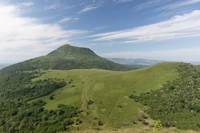
This is the "land" of the Auvergne volcanoes, the Monts Dore, and several puys, along with numerous lakes and gorges like those of the Sioule. In short, the department is a nature destination par excellence, offering a wide range of outdoor activities in both summer and winter, with several ski resorts. Additionally, Puy-de-Dôme is home to beautiful medieval castles and villages to explore...

Overview

Château de Chazeron, Puy-de-Dôme, France
Château de Chazeron, Puy-de-Dôme, France · © VoyageForum

Key Facts

  • Type of place: department.
  • Location: in central France, in the Massif Central.
  • Department code: 63.
  • Bordering departments: Allier, Cantal, Corrèze, Creuse, Loire, and Haute-Loire.
  • Prefecture: Clermont-Ferrand.
  • Sub-prefectures: Ambert, Issoire, Riom, and Thiers.
  • Number of communes: 467.
  • Population: 653,742 inhabitants (2017).
  • Area: 7,970 km².
  • Density: 81 inhabitants/km².
  • Highest point: Puy de Sancy (1,886 m).
  • Lowest point:
  • Coastline: 0 km; no maritime access.
  • Highlights (out of ): Nature / ; Culture ; Relaxation-holidays /

History of Puy-de-Dôme

Geography and Environment

Culture and Economy

What to See in Puy-de-Dôme

This is the "land" of the Auvergne volcanoes, the Monts Dore, and several puys, along with numerous lakes and gorges like those of the Sioule. In short, the department is a nature destination par excellence, offering a wide range of outdoor activities in both summer and winter, with several ski resorts. Additionally, Puy-de-Dôme is home to beautiful medieval castles and villages to explore...

What to Do in Puy-de-Dôme

- Horseback riding: equestrian centers as well as opportunities for rides and hikes for all levels and durations. Don’t forget donkey treks (see details).

- Cycling and mountain biking: country trails or mountain routes—the region has plenty to offer cycling enthusiasts. Highlights include hundreds of kilometers of marked mountain bike trails, the ascent of Puy Mary (in Cantal), the Grande Traversée des Volcans, and the Véloroute 70 (see details).

- Whitewater and water sports: canoeing, kayaking, paddleboarding, rafting, canyoning, and whitewater swimming—the department’s rivers and lakes provide plenty of options for water sports enthusiasts. There are also opportunities for sailing, windsurfing, and waterskiing on certain lakes, which are also great for swimming (see details).

- Fishing: thousands of kilometers of rivers and dozens of lakes make the region a favorite spot for anglers (see details).

- Hiking: in the Volcanoes of Auvergne Regional Nature Park, along lakes and rivers, or on the high plateaus around Aubrac—all levels of hiking are possible on the hundreds of kilometers of marked trails in Puy-de-Dôme (see details).

- Wellness: spas, balneotherapy, and especially thermal baths in Auvergne (see details).

- Winter sports: Puy-de-Dôme ("63") isn’t necessarily the first department that comes to mind for winter activities. Yet, it has around ten resorts (including Mont Dore and Super Besse), offering opportunities for ski touring, snowshoeing, or dog sledding (see details).

- From the sky: Auvergne and its volcanoes seen from above in a hot-air balloon, ultralight aircraft, paraglider, hang glider, parachute, or glider (see details).

Climate and Weather

Transport

Getting There

Getting Around

Accommodation

Food

Additional Information

Clermont-Ferrand

The city has an old centre around its cathedral and a network of underground cellars. Overview of Clermont-Ferrand Climate and Weather in Clermont-Ferrand What to See in Clermont-Ferrand Things to Do in Clermont-Ferrand Flying to Clermont-Ferrand Getting to Clermont-Ferrand by Land Getting Around Clermont-Ferrand Sleeping and Eating in Clermont-Ferrand Living in Clermont-Ferrand

Further information

View guide page: Clermont-Ferrand

Overview of Clermont-Ferrand

Overview of Clermont-Ferrand

The city has an old centre around its cathedral and an underground network of caves.

Landmarks

  • Type of place: large city.
  • Tourist interest: (worth a stop if you are in the area).
  • Location:
  • Distances:
  • Local time: Heure : 18786.
  • Population: 141,365 inhabitants and around 475,000 for the greater urban area (2014).
  • Area: 42.67 km².
  • Altitude: from 321 to 602 m.

History of Clermont-Ferrand

Useful addresses

  • Tourist office:

Services

  • Local agencies:
  • Banks:
  • Hospital:
  • Internet:
  • Laundromats:
  • Vehicle rental:
  • Post office:
View guide page: Overview of Clermont-Ferrand

Climate and Weather in Clermont-Ferrand

Climate Overview

Best Time to Visit Clermont-Ferrand

Jan.Feb.Mar.Apr.MayJun.Jul.Aug.Sep.Oct.Nov.Dec.
Climate

Climate and Forecast

Further Information

View guide page: Climate and Weather in Clermont-Ferrand

What to See in Clermont-Ferrand

Notre-Dame du Port Basilica ★ This is a collegiate church in the "Auvergne Romanesque" style, built in the 12th century. It is a UNESCO World Heritage Site as part of the Routes of Santiago de Compostela. Cathédrale Notre-Dame de l'Assomption ★★ This medieval…

Read the full guide: What to See in Clermont-Ferrand

Flying to Clermont-Ferrand

Clermont-Ferrand Airport

Airport details

  • Name: Clermont-Ferrand Auvergne Airport.
  • IATA code: CFE
  • Hub: no.
  • Number of terminals: 1.
  • Annual passenger capacity:
  • Passenger traffic: 430,696 (2018).
  • Distance from city centre: 7 km east of the city.

Services

Sleeping at the airport

Transport to the city centre

Other nearby airports

From the rest of the country

From elsewhere

Additional information

View guide page: Flying to Clermont-Ferrand

Auvergne Volcanoes Regional Nature Park

France’s largest regional park offers stunning landscapes, lakes, charming villages, a few ski resorts, and above all, countless hiking opportunities. Since 2018, the "Chaîne des Puys" it encompasses has been inscribed on the UNESCO World Heritage list.

Overview of the park

France’s largest regional park offers stunning landscapes, lakes, charming villages, a few ski resorts, and above all, countless hiking opportunities. Since 2018, the "Chaîne des Puys" it encompasses has been inscribed on the UNESCO World Heritage list.

Key facts

  • Tourist interest: (must-see or highly recommended).
  • Characteristics:
  • Area: 3,897 km²
  • Altitude:

Environment

Wildlife and flora

Precautions

Climate and weather

What to see and do

Practical information

  • Location:
  • Opening period:
  • How to get there:
  • Distances:

Accommodation and dining

Nearby attractions

Further information

View guide page: Auvergne Volcanoes Regional Nature Park

Livradois-Forez Regional Nature Park

This park spanning two regions offers beautiful landscapes, including the Monts du Forez, as well as opportunities for hiking and skiing. It can also be partly explored via the Livradois-Forez tourist train.

Overview of the park

This park spanning two regions offers beautiful landscapes, including the Monts du Forez, as well as opportunities for hiking and skiing. It can also be partly explored via the Livradois-Forez tourist train.

Key points

  • Tourist interest: (worth seeing).
  • Features:
  • Area: 3,220 km².
  • Altitude:

Environment

Landscape of the park

Wildlife and flora

Precautions

Climate and weather

Precautions

What to see and do

Practical information

  • Location:
  • Opening period:
  • How to get there:
  • Distances:

Accommodation and dining

Nearby attractions

Additional information

View guide page: Livradois-Forez Regional Nature Park

Mozac Abbey

Located in the town of the same name, it is one of the most important abbeys in Auvergne.

Overview of the Abbey

Located in the town of the same name, it is one of the most important abbeys in Auvergne.

  • Tourist interest: (worth a stop if you are in the area).

History of the Abbey

What to See and Do

Practical Information

  • Location:
  • Address: 63200 Mozac.
  • Opening hours:
  • Price:
  • Website:
  • How to get there:

What to See Nearby

  1. == En complément
View guide page: Mozac Abbey

Orcival Basilica

This beautiful Romanesque church can be discovered in the village of Orcival, nestled in a valley.

Overview of the Basilica

This beautiful Romanesque church can be discovered in the village of Orcival, nestled in a valley.

  • Tourist interest: (worth a stop if you are in the area).

History of the Basilica

What to See and Do

Practical Information

  • Location:
  • Address: Place de la Basilique, 63210 Orcival.
  • Opening hours:
  • Price:
  • Website:
  • How to get there:

Nearby Attractions

  1. == In addition
View guide page: Orcival Basilica

Aulteribe Castle

This is a medieval castle, restored in the Romantic style in the 19th century, located in the commune of Sermentizon.

Overview of the castle

This is a medieval castle, restored in the Romantic style in the 19th century, located in the commune of Sermentizon.

  • Tourist interest: (worth a stop if you are in the area).

History of the castle

What to see and do

Practical information

  • Location:
  • Address: 63120 Sermentizon.
  • Opening hours:
  • Price:
  • How to get there:

What to see nearby

  1. == In addition
View guide page: Aulteribe Castle

Château de Chazeron

In Loubeyrat, a medieval château later expanded in the style of Versailles.

Overview of the château

In Loubeyrat, a medieval château later expanded in the style of Versailles.

  • Tourist interest: (worth seeing).

History of the château

What to see and do

Practical information

  • Location:
  • Address: Hamlet of Chazeron, 63410 Loubeyrat.
  • Opening hours:
  • Price:
  • How to get there:

Nearby attractions

  1. == En complément
View guide page: Château de Chazeron

Murol Castle

These are the remains of an old fortified castle perched not far from Mont-Dore, facing the Sancy Massif.

Overview of the castle

These are the remains of an old fortified castle perched not far from Mont-Dore, facing the Sancy Massif.

  • Tourist interest: (worth seeing).

History of the castle

What to see and do

Practical information

  • Location:
  • Address: Rue du château, 63790 Murol.
  • Opening hours:
  • Price:
  • How to get there:

What to see nearby

  1. == In addition
View guide page: Murol Castle

Villeneuve-Lembron Castle

A fine 15th-century seigneurial residence.

Overview of the castle

A fine 15th-century seigneurial residence.

  • Tourist interest: (worth a stop if you are in the area).

History of the castle

What to see and do

Practical information

  • Location:
  • Address: 63340 Villeneuve-Lembron.
  • Opening hours:
  • Price:
  • How to get there:

What to see nearby

  1. == In addition
View guide page: Villeneuve-Lembron Castle

Issoire

This sub-prefecture in Puy-de-Dôme is home to a charming Romanesque abbey church (Saint-Austremoine) and several other interesting religious buildings.

Overview of Issoire

Issoire is a sub-prefecture in Puy-de-Dôme. It is home to a charming Romanesque abbey church (Saint-Austremoine) and several other interesting religious buildings.

Key facts

  • Type of place: small town.
  • Tourist interest: (worth a stop if you are in the area).
  • Distances:
  • Local time: Heure : 18834.
  • Population: 14,578 inhabitants (2014).
  • Area: 19.69 km².
  • Altitude: from 360 m to 560 m.

History of Issoire

What to see and do in Issoire

In the surrounding area

Climate and weather in Issoire

Transport

Getting there

Getting around

Accommodation

Food

Useful addresses

Further information

View guide page: Issoire

La Bourboule

A small family-friendly spa town in the heart of the Mont-Dore massif.

Overview of La Bourboule

It's a small family-friendly spa town in the heart of the Monts Dore Massif.

Key Facts

  • Type of place: village.
  • Tourist interest: (worth a stop if you are in the area).
  • Location:
  • Distances:
  • Local time: Heure : 18835.
  • Population: 1,782 inhabitants (2014)
  • Area: 12.74 km².
  • Altitude: from 812 to 1,408 m.

History of La Bourboule

What to See and Do

In the Surrounding Area

Climate and Weather

Getting Around

Getting There

Getting Around

Where to Stay

Where to Eat

Useful Addresses

Additional Information

View guide page: La Bourboule

La Sauvetat

South of Clermont-Ferrand, this village is made up of a medieval fortified complex.

Overview of La Sauvetat

Located south of Clermont-Ferrand, the village of La Sauvetat is made up of a medieval fortified complex.

Key facts

  • Type of place: village.
  • Tourist interest: (worth seeing).
  • Distances: Clermont-Ferrand (17 km), Issoire (12 km), Le Mont Dore ( km).
  • Local time: Heure : 18836.
  • Population: 696 inhabitants (2014).
  • Area: 8 km².
  • Altitude: from 356 to 580 m.
  • Website:

History of La Sauvetat

What to see and do in La Sauvetat

The heart of the village is a beautiful medieval fortified complex, featuring a keep and ramparts.

In the surrounding area

Climate and weather in La Sauvetat

Transport

Getting there

Getting around

Accommodation

Eating

Useful addresses

Further information

View guide page: La Sauvetat

Grand Sancy

The main ski resort in the Massif Central, created by combining the ski areas of Super-Besse and Mont-Dore. It is located in the Puy de Sancy.

Overview of the resort

The main ski resort in the Massif Central was created by combining the ski areas of Super-Besse and Mont-Dore. It is located in the Puy de Sancy.

Key facts

  • Tourist interest: (worth seeing).
  • Mountain range: Massif Central.
  • Associated resorts: 2.
  • Altitude: from 1,050 to 1,835 m.

Environment

Climate and weather

Precautions

Facilities and activities

Ski area

  • Opening period:
  • Number of slopes: 58.
  • Slope length: 84 km.
  • Cross-country ski trails: 44 km.

Other winter activities

Summer activities

Practical information

  • Location:
  • Website:
  • Distances:

Accommodation and dining

Events

What to see and do nearby

Additional information

View guide page: Grand Sancy

Montpeyroux

Just near Clermont, this small hilltop village dominated by its keep is listed among the "Most Beautiful Villages of France".

Introduction to Montpeyroux

Just near Clermont, the small hilltop village of Montpeyroux, dominated by its keep, is listed among the "Most Beautiful Villages of France".

Key Facts

  • Type of place: village.
  • Tourist interest: (worth seeing).
  • Distances:
  • Local time: Heure : 18838.
  • Population: 346 inhabitants. (2014).
  • Area: 3.29 km².
  • Altitude: from 342 to 484 m.

History of Montpeyroux

What to See and Do in Montpeyroux

This hilltop village above the Allier Valley is made up of old houses nestled at the foot of a 12th-century keep, the last remnant of Montpeyroux Castle.

In the Surrounding Area

Climate and Weather in Montpeyroux

Transportation

Getting There

Getting Around

Accommodation

Dining

Useful Addresses

Further Information

View guide page: Montpeyroux

Riom

This sub-prefecture has an old town centre where you can still see beautiful houses built from volcanic stone.

Overview of Riom

The sub-prefecture of Riom has an old town centre where you can still see beautiful houses built from volcanic stone.

Key facts

  • Type of place: small town.
  • Tourist interest: (worth a stop if you are in the area).
  • Distances:
  • Local time: Heure : 18839.
  • Population: 19,029 inhabitants (2016).
  • Area: 31.97 km²
  • Altitude: from 314 to 505 m.

History of Riom

What to see and do in Riom

Mandet Museum
It houses a collection of paintings and sculptures from the 16th to the 19th century, as well as art objects from antiquity to the present day.
Auvergne Regional Museum
The museum houses over 4,000 objects offering a glimpse into rural Auvergne in the 19th century.

In the surrounding area

Climate and weather in Riom

Transport

Getting there

Getting around

Accommodation

Eating out

Useful addresses

Further information

View guide page: Riom

Mandet Museum

It houses a collection of paintings and sculptures from the 16th to the 19th century, as well as art objects from antiquity to the present day.

Overview of the museum

It houses a collection of paintings and sculptures from the 16th to the 19th century, as well as art objects from antiquity to the present day.

  • Tourist interest: (worth a stop if you are in the area).

History of the Mandet Museum

Collections on display

Practical information

  • Location:
  • Address: 14 rue de l'Hôtel de ville, 63200 Riom.
  • Opening hours:
  • Admission:
  • How to get there:

Nearby attractions

View guide page: Mandet Museum

Auvergne Regional Museum

The museum houses over 4,000 objects offering a glimpse into rural Auvergne in the 19th century.

Overview of the museum

The museum houses over 4,000 objects offering a glimpse into rural Auvergne in the 19th century.

  • Tourist interest: (worth a stop if you are in the area).

History of the museum

Collections on display

Practical information

  • Location:
  • Address: 10 bis rue Delille, 63200 Riom.
  • Opening hours:
  • Admission:
  • How to get there:

Nearby attractions

  1. == In addition
View guide page: Auvergne Regional Museum

Saint-Floret

A stunning medieval village with pink-tiled houses, once listed among the "Most Beautiful Villages of France".

Overview of Saint-Floret

Saint-Floret is a stunning medieval village with pink-tiled houses, once listed among the "Most Beautiful Villages of France".

Key Details

  • Type de lieu: village.
  • Intérêt touristique: (worth seeing).
  • Localisation: in the southern part of the Puy-de-Dôme department, not far from Issoire.
  • Distances:
  • Heure locale: Heure : 18840.
  • Population: 263 inhabitants (2014).
  • Superficie: 12.16 km².
  • Altitude: from 476 to 929 m.

History of Saint-Floret

What to See and Do in Saint-Floret

This old village is clustered at the foot of its keep and the few remains of its medieval castle perched on a rocky outcrop, forming a beautiful ensemble once listed among the "Most Beautiful Villages of France".

Saint-Floret Castle
On the outskirts of the village, these are the ruins of a medieval castle built atop a rocky ridge.
Chastel Archaeological Site
Near the Chastel church, the site contains an ossuary and anthropomorphic tombs from the Middle Ages.

In the Surrounding Area

Climate and Weather in Saint-Floret

Transportation

Getting There

Getting Around

Accommodation

Dining

Useful Addresses

Further Information

View guide page: Saint-Floret

Saint-Floret Castle

On the outskirts of the village, these are the ruins of a medieval castle built atop a rocky ridge.

Overview of the castle

On the outskirts of the village, these are the ruins of a medieval castle built atop a rocky ridge.

  • Tourist interest: (worth a stop if you are in the area).

History of the castle

What to see and do

Practical information

  • Location:
  • Address:
  • Opening hours:
  • Price:
  • How to get there:

What to see nearby

  1. == En complément
View guide page: Saint-Floret Castle

Chastel Archaeological Site

Near the Chastel church, the site contains an ossuary and anthropomorphic tombs from the Middle Ages.

Overview of the Site

Near the Chastel church, the site contains an ossuary and anthropomorphic tombs from the Middle Ages.

  • Tourist interest: (worth a stop if you are in the area).
  • Features:
  • Area:
  • Altitude:

History of the Archaeological Site

What to See and Do

Practical Information

  • Location:
  • Address: 63320 Saint-Floret.
  • Opening hours:
  • Price:
  • Website:
  • How to get there:

Nearby Attractions

  1. == In addition
View guide page: Chastel Archaeological Site

Saint-Nectaire

Beyond the cheese that made it famous, the village is also home to one of the region’s most beautiful Romanesque churches.

Overview of Saint-Nectaire

Beyond the cheese that made it famous, the village of Saint-Nectaire is also home to one of the region’s most beautiful Romanesque churches.

Key Facts

  • Type of place: village.
  • Tourist interest: (worth a stop if you are in the area).
  • Distances:
  • Local time: Heure : 18841.
  • Population: 725 inhabitants (2014).
  • Area: 33.26 km².
  • Altitude: from 609 to 1,011 m.

History of Saint-Nectaire

What to See and Do in Saint-Nectaire

In the Surrounding Area

Climate and Weather in Saint-Nectaire

Transportation

Getting There

Getting Around

Accommodation

Dining

Useful Addresses

Further Information

View guide page: Saint-Nectaire

Saint-Saturnin

A beautiful Romanesque church and a medieval fortress with houses clustered around them have earned this village a place among the "Most Beautiful Villages of France" at one time.

Overview of Saint-Saturnin

A beautiful Romanesque church and a medieval fortress with houses clustered around them have earned the village of Saint-Saturnin a place among the "Most Beautiful Villages of France" at one time.

Key Details

  • Type of place: small town.
  • Tourist interest: (worth a stop if you are in the area).
  • Distances:
  • Local time: Heure : 18842.
  • Population: 1,118 inhabitants (2014).
  • Area: 16.86 km².
  • Altitude: from 460 to 890 m.

History of Saint-Saturnin

What to See and Do in Saint-Saturnin

A beautiful 12th-century Romanesque church and a restored medieval castle with houses clustered around them form the heart of this small town.

In the Surrounding Area

Climate and Weather in Saint-Saturnin

Transportation

Getting There

Getting Around

Accommodation

Dining

Useful Addresses

Additional Information

View guide page: Saint-Saturnin

Thiers

This town has a charming old centre, featuring many half-timbered houses, several manors, and various churches. Alongside this, Thiers also boasts a notable industrial heritage due to its cutlery industry.

Overview of Thiers

The town has a charming old centre, featuring many half-timbered houses, several manors, and various churches. Alongside this, Thiers also boasts a notable industrial heritage due to its cutlery industry.

Key Facts

  • Type of place: small town.
  • Tourist interest: (worth seeing).
  • Location: sub-prefecture of the Puy-de-Dôme department, not far from Clermont-Ferrand.
  • Distances: Clermont-Ferrand ( km), Lyon ( km), Saint-Étienne ( km), Vichy ( km).
  • Local time: Heure : 18843.
  • Population: 11,588 inhabitants (2014).
  • Area: 44.49 km².
  • Altitude: from 283 to 793 m.

History of Thiers

What to See and Do in Thiers

Old Town of Thiers
This is a medieval centre featuring numerous half-timbered houses, several manors, its jaquemart, and various churches and chapels.
Hell's Hollow
The place is a contemporary art centre.
Thiers Cutlery Museum
The museum traces the history and craftsmanship of knives, a specialty of the town.
Thiers Factory Valley
This is the Durolle Valley and its industrial heritage. You can still see the oldest factory in the town still in operation (a cutlery manufacturer) and many 19th-century workers' housing. Nearby, the Rouets Valley and the remains of its former blade-grinding workshops.

In the Surrounding Area

Climate and Weather in Thiers

Transport

Getting There

Getting Around

Accommodation

Food

Useful Addresses

Further Information

View guide page: Thiers

Old Town of Thiers

This is a medieval centre featuring numerous half-timbered houses, several manors, its jaquemart, and various churches and chapels.

Overview of the District

This is a medieval centre featuring numerous half-timbered houses, several manors, its jaquemart (automated bell-striker), and various churches and chapels.

  • Tourist interest: (worth seeing).

History of the Old Town of Thiers

What to See and Do

Events and Activities

Practical Information

  • Location:
  • How to get there:
  • How to get around:

Eat

Sleep

What to See Nearby

  1. == Further reading
View guide page: Old Town of Thiers

Thiers Cutlery Museum

The museum traces the history and craftsmanship of knives, a specialty of the town.

Overview of the Museum

The museum traces the history and craftsmanship of knives, a specialty of the town.

  • Tourist interest: (worth a stop if you are in the area).

History of the Museum

Collections on Display

Practical Information

  • Location:
  • Address: 58 rue de la Coutellerie, 63300 Thiers.
  • Opening hours:
  • Admission:
  • How to get there:

Nearby Attractions

  1. == In addition
View guide page: Thiers Cutlery Museum

Thiers Factory Valley

This is the Durolle Valley and its industrial heritage. You can still see the oldest factory in the town still in operation (a cutlery manufacturer) and many 19th-century workers' housing. Nearby, the Rouets Valley and the remains of its former blade-grinding workshops.

Overview of the site

This is the Durolle Valley and its industrial heritage. You can still see the oldest factory in the town still in operation (a cutlery manufacturer) and many 19th-century workers' housing. Nearby, the Rouets Valley and the remains of its former blade-grinding workshops.

  • Tourist interest: (worth seeing).

History of the Thiers Factory Valley

What to see and do

Practical information

  • Location:
  • Local time: Heure : 22022.
  • Address: 63300 Thiers, France.
  • Opening hours:
  • Price:

Transport

Sleeping and eating

What to see nearby

  1. == En complément
View guide page: Thiers Factory Valley

Hell's Hollow

The place is a contemporary art centre.

Overview of Hell's Hollow

It is a contemporary art centre.

  • Tourist interest: (worth a stop if you are in the area).

History of Hell's Hollow

Exhibitions and events

Practical information

  • Location:
  • Address: 85 avenue Joseph Claussat, 63300 Thiers.
  • Opening hours:
  • Price:
  • How to get there:

What to see nearby

View guide page: Hell's Hollow

Usson

A beautiful village perched on a volcanic peak, offering a lovely panorama of the surrounding area.

Overview of Usson

Usson is a beautiful village perched on a volcanic peak, offering a lovely panorama of the surrounding area.

Key details

  • Type de lieu: village.
  • Intérêt touristique: (worth a stop if you are in the area).
  • Localisation: in the Puy-de-Dôme department, near Issoire.
  • Distances:
  • Heure locale: Heure : 18844.
  • Population: 271 inhabitants (2014).
  • Superficie: 5.43 km².
  • Altitude: from 394 to 633 m.
  • Site internet:

History of Usson

What to see and do in Usson

Perched on its peak, offering a beautiful panorama of the Chaîne des Puys, the village consists of old winegrowers' houses made of black stone and (rare) remnants of its former fortress.

Usson Basaltic Organs
A trail starting from the village leads to nearby stunning basaltic organs, evidence of the region's volcanic activity.

In the surrounding area

Climate and weather in Usson

Transport

Getting there

Getting around

Accommodation

Food

Useful addresses

Further information

View guide page: Usson

Usson Basaltic Organs

A trail starting from the village leads to nearby stunning basaltic organs, evidence of the region's volcanic activity.

Overview of the Site

A trail starting from the village leads to nearby stunning basaltic organs, evidence of the region's volcanic activity.

Key Details

  • Type of site: rock formation.
  • Tourist interest: (worth a stop if you are in the area).
  • Features:
  • Location:
  • Area:
  • Altitude:

Environment

Wildlife and Flora

Precautions

What to See and Do

In the Surrounding Area

Climate and Weather

Getting There

Accommodation and Dining

  1. == In Addition
View guide page: Usson Basaltic Organs

Fades Viaduct

This impressive railway viaduct, dating from the very beginning of the 20th century, was once the world's highest bridge.

Overview of the viaduct

This impressive railway viaduct, dating from the very beginning of the 20th century, was once the world's highest bridge.

  • Tourist interest: (worth a stop if you are in the area).

History of the viaduct

What to see and do

Practical information

  • Location:
  • Address: 63390 Sauret-Besserve.
  • Opening hours:
  • Price:
  • How to get there:

What to see nearby

  1. == In addition
View guide page: Fades Viaduct

Volvic

Internationally renowned for its natural water, Volvic is also home to the remains of a medieval fortress: the Château de Tournoël.

Overview of Volvic

Internationally known for its natural water, Volvic is also home to the remains of a medieval fortress: the Château de Tournoël.

Key Facts

  • Type de lieu: small town.
  • Intérêt touristique: (worth a stop if you are in the area).
  • Localisation: in the heart of the Puy-de-Dôme department, not far from Clermont-Ferrand.
  • Distances:
  • Heure locale: Heure : 18846.
  • Population: 4,387 inhabitants (2014).
  • Superficie: 27.78 km².
  • Altitude: from 392 to 998 m.

History of Volvic

What to See and Do in Volvic

Tournoël Castle
It is a medieval fortress perched above the surrounding area. It is partially in ruins.
Volvic Information Space
The history of the Société des Eaux de Volvic and tastings of mineral or flavored waters.
Volvic Stone Cave
This is the world of quarry workers in the 1900s, brought to life through various scenographies set in an old quarry at the heart of a volcano’s lava flow.
Marcel Sahut Museum
Housed in the Château de Bosredon, known for its beautiful French-style gardens. Here you’ll find paintings, drawings, and prints from the 19th and 20th centuries, as well as Asian bronzes and African masks.

In the Surrounding Area

Climate and Weather in Volvic

Transport

Getting There

Getting Around

Accommodation

Dining

Useful Addresses

Further Information

View guide page: Volvic

Volvic Stone Cave

This is the world of quarry workers in the 1900s, brought to life through various scenographies set in an old quarry at the heart of a volcano’s lava flow.

Overview of the Site

This is the world of quarry workers in the 1900s, brought to life through various scenographies set in an old quarry at the heart of a volcano’s lava flow.

Key Details

  • Type of place: cave.
  • Tourist interest: (worth a stop if you are in the area).
  • Features:
  • Area:

Cave Layout

What to See and Do

Practical Information

  • Location:
  • Address: 2 route du Pont Jany, 63530 Volvic.
  • Opening hours:
  • Price:

Getting There

Sleeping and Eating

Nearby Attractions

  1. == In addition
View guide page: Volvic Stone Cave

Tournoël Castle

It is a medieval fortress perched above the surrounding area. It is partially in ruins.

Overview of the castle

It is a medieval fortress perched above the surrounding area. It is partially in ruins.

  • Tourist interest: (worth a stop if you are in the area).

History of Tournoël Castle

What to see and do

Practical information

  • Location:
  • Local time: Heure : 22026.
  • Address: 1 rue des Remparts, 63530 Volvic.
  • Opening hours:
  • Price:

Transport

Sleeping and eating

What to see nearby

  1. == En complément
View guide page: Tournoël Castle

Volvic Information Space

The history of the Société des Eaux de Volvic and tastings of mineral or flavored waters.

Overview of Volvic Information Space

The history of the Société des Eaux de Volvic and tastings of mineral or flavored waters.

Key Details

  • Type of place: spring.
  • Tourist interest: (worth a stop if you are in the area).
  • Features:
  • Altitude:

What to See and Do

Practical Information

  • Location:
  • Distances:

Getting There

Accommodation and Dining

Nearby Attractions

  1. == En complément
View guide page: Volvic Information Space

Marcel Sahut Museum

Housed in the Château de Bosredon, known for its beautiful French-style gardens. Here you’ll find paintings, drawings, and prints from the 19th and 20th centuries, as well as Asian bronzes and African masks.

Overview of the Marcel Sahut Museum

Housed in the Château de Bosredon, known for its beautiful French-style gardens. Here you’ll find paintings, drawings, and prints from the 19th and 20th centuries, as well as Asian bronzes and African masks.

  • Tourist interest: (worth a stop if you are in the area).

History of the museum

Collections on display

Practical information

  • Location:
  • Address: 2 rue des Écoles, 63530 Volvic.
  • Opening hours:
  • Admission:
  • How to get there:

Nearby attractions

  1. == In addition
View guide page: Marcel Sahut Museum

Vulcania

West of Clermont-Ferrand, in Saint-Ours, Vulcania is a mix of museum and theme park dedicated to volcanoes.

Overview of the park

West of Clermont-Ferrand, in Saint-Ours, Vulcania is a mix of museum and theme park dedicated to volcanoes.

  • Tourist interest: (worth seeing).

Attractions and facilities

Practical information

  • Location:
  • Address: Route de Mazayes, 63230 Saint-Ours-les Roches.
  • Opening hours:
  • Price:
  • How to get there:

Nearby sights

Additional information

View guide page: Vulcania

Banne d'Ordanche

A volcanic peak above La Bourboule that you can reach the summit of with a short walk.

Overview of Banne d'Ordanche

This is a volcanic peak above La Bourboule that you can reach the summit of with a short walk.

  • Tourist interest: (worth seeing).
  • Features:
  • Massif: Massif Central.
  • Summit: 1,512 m.

Site Environment

Wildlife and Flora

Climate and Weather

Precautions

What to See and Do

Practical Information

  • Location:
  • Website:
  • How to Get There:
  • Distances:

Sleeping and Eating

Nearby Attractions

  1. == En complément
View guide page: Banne d'Ordanche

Lake Aydat

It is the largest lake in Auvergne. It hosts a water sports centre and is popular with anglers.

Overview of the lake

It is the largest lake in Auvergne. It hosts a water sports centre and is popular with anglers.

Key details

  • Tourist interest: (worth a stop if you are in the area).
  • Features: natural lake
  • Surface area: 0.65 km²
  • Altitude: 837 m.

Environment

Precautions

What to see and do

Practical information

  • Location:
  • Website:
  • How to get there:
  • Distances:

Sleeping and eating

What to see nearby

  1. == In addition
View guide page: Lake Aydat

Lake Guéry

This high-altitude lake (the highest in Auvergne) is renowned for fishing, even in winter through the ice that covers it. There are many other lakes nearby.

Overview of the lake

This high-altitude lake (the highest in Auvergne) is renowned for fishing, even in winter through the ice that covers it. There are many other lakes nearby.

Key details

  • Tourist interest: (worth seeing).
  • Characteristics: high-altitude volcanic lake.
  • Surface area: 0.25 km².
  • Altitude: 1,244 m.

Environment

Precautions

What to see and do

Practical information

  • Location:
  • Website:
  • How to get there:
  • Distances:

Sleeping and eating

What to see nearby

  1. == In addition
View guide page: Lake Guéry

Puy de Sancy

At 1,885 m, it is the highest peak in the Massif Central. You can hike in the surrounding area or ski at the Mont-Dore, Super-Besse, and Chastreix-Sancy resorts.

Overview of Puy de Sancy

At 1,885 m, it is the highest peak in the Massif Central. You can hike in the surrounding area or ski at the Mont-Dore, Super-Besse, and Chastreix-Sancy resorts.

Key details

  • Tourist interest: (recommended).
  • Features:
  • Massif: Massif Central
  • Summit: 1,885 m.

Environment

Wildlife and flora

Precautions

Climate and weather

What to see and do

Practical information

  • Location:
  • How to get there:
  • Distances:

Accommodation and dining

What to see nearby

  1. == In addition
View guide page: Puy de Sancy

Monts Dore Massif

A charming volcanic massif with lakes and extinct volcanoes located in the Volcanoes of Auvergne Park. It’s a popular spot for hiking, skiing, or exploring the many thermal resorts in the area. It’s also home to Puy de Sancy, the highest peak in the Massif Central.

Overview of the Monts Dore Massif

This is a charming volcanic massif with numerous lakes and extinct volcanoes located in the Volcanoes of Auvergne Park. It’s a popular destination for hiking, skiing, or discovering the many thermal resorts in the area. It’s also home to the Puy de Sancy, the highest peak in the Massif Central.

Key Details

  • Tourist interest: (recommended).
  • Characteristics:
  • Massif: Massif Central.
  • Area:

Environment

Wildlife and Flora

Population and Economic Activity

Precautions

Climate and Weather

What to See and Do

Practical Information

  • Location:
  • How to Get There:
  • Distances:

Getting Around

Accommodation and Dining

Nearby Attractions

Additional Resources

View guide page: Monts Dore Massif

Something wrong or out of date? Report this page