Skip to content
Pyrénées-Atlantiques

Travel guide · France

Pyrénées-Atlantiques

★ 4 · last edited Aug 5, 2020 · 4 versions

The department is located at the extreme southwest of France, bordering Spain.

Overview

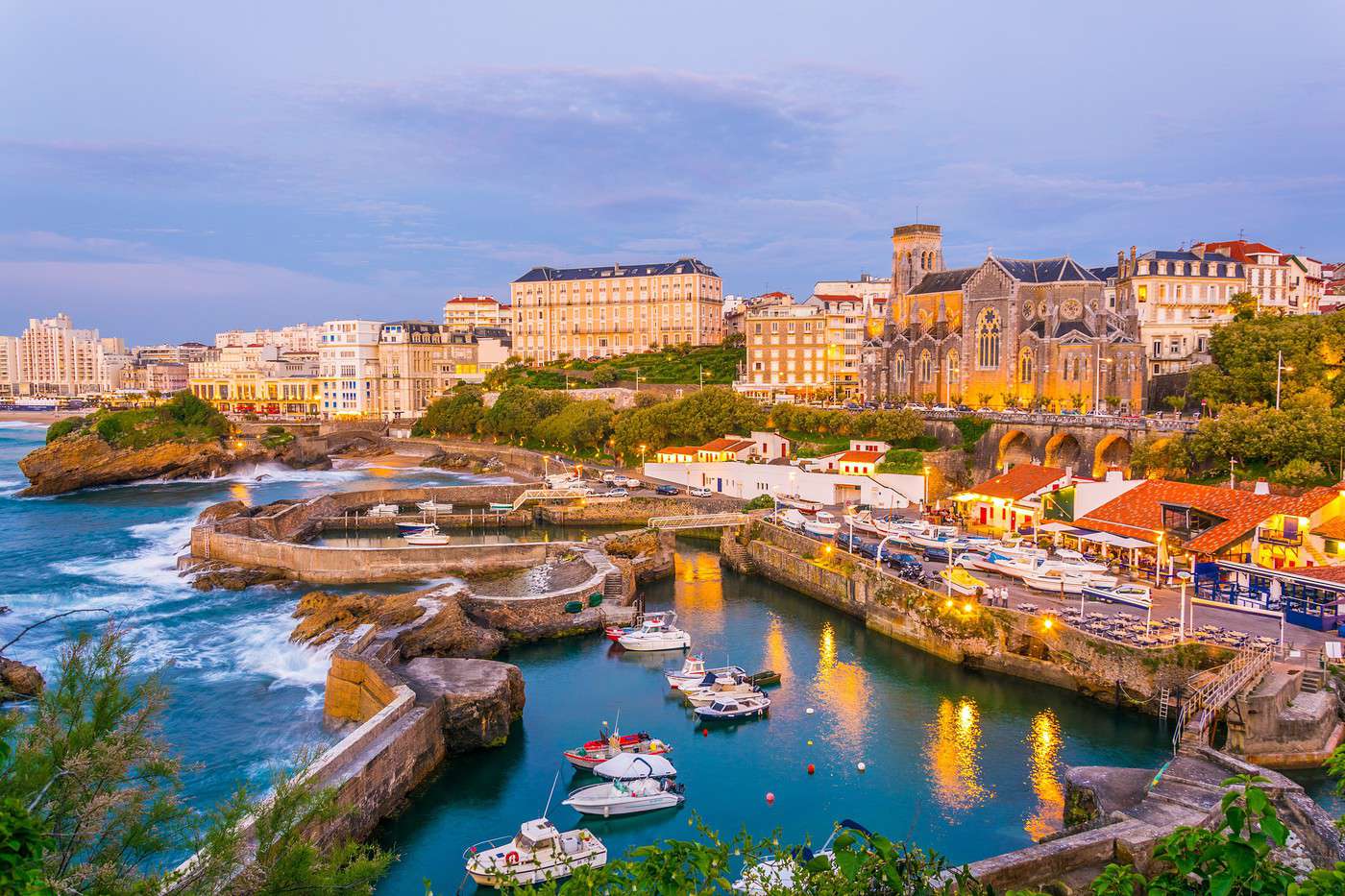
Biarritz, Pyrénées-Atlantiques, France
Biarritz, Pyrénées-Atlantiques, France · © VoyageForum

Key Facts

  • Type of place: department.
  • Location: at the extreme southwest of France, bordering Spain.
  • Department code: 64.
  • Bordering departments: Gers, Hautes-Pyrénées, Landes (plus Spain).
  • Prefecture: Pau.
  • Sub-prefectures: Bayonne and Oloron-Sainte-Marie.
  • Number of municipalities: 546.
  • Population: 677,309 inhabitants (2017).
  • Area: 7,645 km².
  • Highest point: Pic Palas (2,974 m).
  • Lowest point: sea level.
  • Coastline:
  • Highlights (out of ): Nature ; Culture / ; Relaxation-holidays

History of the Pyrénées-Atlantiques

Geography and Environment

Culture and Economy

What to See in the Pyrénées-Atlantiques

The "64" is a department rich in tourism. Thanks to its geographical location, you can enjoy both the beaches and water activities of the Atlantic coast and the ski resorts of the Pyrenees. Not to mention all the opportunities offered by the mountains (Pyrénées National Park) and the countryside in this lovely corner of France. Additionally, a large part of the department forms the Basque Country, with its own culture and traditions.

What to Do in the Pyrénées-Atlantiques

Climate and Weather

Sea Temperature Throughout the Year

Jan.Feb.Mar.Apr.MayJun.Jul.Aug.Sep.Oct.Nov.Dec.
Pyrénées-Atlantiques111111121416182018171412

Transport

Getting There

Getting Around

Accommodation

Food

Further Reading

Biarritz

For a long time, one of the most prestigious seaside resorts on the Atlantic coast. Its attractions include "bourgeois" mansions, the Rocher de la Vierge, and, in another domain, excellent surf spots. For a long time, one of the most prestigious seaside…

Read the full guide: Biarritz

Holzarte Gorge

These are narrow and spectacular gorges located in the Basque Country. A footbridge over 180 m high spans them, allowing visitors to cross.

Overview of the gorges

These are narrow and spectacular gorges located in the Basque Country. A footbridge over 180 m high spans them, allowing visitors to cross.

  • Tourist interest: (worth seeing).
  • Features:
  • Length:
  • Depth: between 100 and 300 m.
  • Altitude:

Site environment

Wildlife and flora

Climate and weather

Precautions

What to see and do

Practical information

  • Location:
  • Website:
  • How to get there:
  • Distances:

Sleeping and eating

What to see nearby

  1. == In addition
View guide page: Holzarte Gorge

Kakuetta Gorge

Beautiful Basque gorges located in the municipality of Sainte-Engrâce. They are quite popular in the summer.

Overview of the gorge

These are beautiful Basque gorges located in the municipality of Sainte-Engrâce. They are quite popular in the summer.

  • Tourist interest: (worth seeing).
  • Features:
  • Length: 2 km.
  • Depth:
  • Altitude:

Site environment

Wildlife and flora

Climate and weather

Precautions

What to see and do

Practical information

  • Location:
  • Website:
  • How to get there:
  • Distances:

Sleeping and eating

Nearby attractions

  1. == In addition
View guide page: Kakuetta Gorge

Bétharram Caves

A series of caves to explore on the border of the Hautes-Pyrénées and Pyrénées-Atlantiques.

Overview of the caves

This is a series of caves to explore on the border of the Hautes-Pyrénées and Pyrénées-Atlantiques.

  • Tourist interest: (worth seeing).
  • Features: undecorated caves.
  • Area:

Cave layout

What to see and do

Practical information

  • Location:
  • Address: 64800 Lestelle-Bétharram and 65270 Saint-Pé-de-Bigorre.
  • Opening hours:
  • Price:
  • How to get there:
  • Distances:

Sleeping and eating

Nearby attractions

  1. == En complément
View guide page: Bétharram Caves

La Rhune

This small Franco-Spanish Pyrenean summit is a tourist destination thanks to the La Rhune rack railway, which offers stunning landscapes and panoramic views. It’s also home to the famous pottoks (small Basque horses) that roam freely.

Overview of La Rhune

This small Franco-Spanish Pyrenean summit is a tourist destination thanks to the La Rhune rack railway, which offers stunning landscapes and panoramic views. It’s also a place where the famous pottoks (small Basque horses) roam freely.

Key Details

  • Tourist interest: (must-see or highly recommended).
  • Features:
  • Mountain range: Pyrenees
  • Summit: 905 m.

Site Environment

Wildlife and Flora

Precautions

Climate and Weather

What to See and Do

Practical Information

  • Location:
  • How to Get There:
  • Distances:

Accommodation and Dining

Nearby Attractions

Additional Information

View guide page: La Rhune

Aldudes Valley

This is a very beautiful small valley in the Basque Country, on the Spanish border.

Overview of the valley

This is a very beautiful small valley in the Basque Country, on the Spanish border.

  • Tourist interest: (worth seeing).
  • Features:
  • Length:
  • Altitude:

Valley environment

Wildlife and flora

Climate and weather

Precautions

What to see and do

Practical information

  • Location:
  • How to get there:
  • Distances:

Getting around

Sleeping and eating

What to see nearby

  1. == En complément
View guide page: Aldudes Valley

Aspe Valley

A stunning wild valley in Béarn with excellent hiking opportunities.

Overview of the valley

This is a stunning wild valley in Béarn with excellent hiking opportunities.

  • Tourist interest: (recommended).
  • Features:
  • Length: 40 km.
  • Altitude:

Valley environment

Wildlife and flora

Climate and weather

Precautions

What to see and do

Practical information

  • Location:
  • How to get there:
  • Distances:

Getting around

Sleeping and eating

Nearby attractions

Additional information

View guide page: Aspe Valley

Ossau Valley and Peak

Dominated by the Pic d'Ossau, this valley in the Pyrénées National Park is one of the main ones in the Béarn region. It’s a major hub for tourism and hiking, with stunning landscapes. Visitors can enjoy the Gourette and Artouste ski resorts, as well as the Artouste little train.

Overview of the valley

Dominated by the Pic d'Ossau, this valley in Pyrénées National Park is one of the main ones in the Béarn region. It’s a major hub for tourism and hiking, with stunning landscapes. For visitors, it offers the Gourette and Artouste ski resorts, as well as the Artouste little train.

Key details

  • Tourist interest: (must-see or highly recommended).
  • Features:
  • Length:
  • Altitude:

Environment

Wildlife and flora

Climate and weather

Precautions

What to see and do

Practical information

  • Location:
  • How to get there:
  • Distances:

Getting around

Accommodation and dining

Nearby attractions

Additional information

View guide page: Ossau Valley and Peak

Ainhoa

On the Camino de Santiago, this small village is one of France’s most beautiful, with its typical Basque architecture of large half-timbered and corbelled houses.

Introduction to Ainhoa

On the Camino de Santiago, the small town of Ainhoa is one of France’s most beautiful villages, with its typical Basque architecture of large half-timbered and corbelled houses.

Key Facts

  • Type of place: village.
  • Tourist interest: (worth seeing).
  • Location: in the south of Pyrénées-Atlantiques, very close to the Spanish border.
  • Distances:
  • Local time: Heure : 19327.
  • Population: 664 inhabitants (2014).
  • Area: 16.19 km².
  • Altitude: from 52 to 649 m.

History of Ainhoa

What to see and do in Ainhoa

This "street bastide" features traditional Basque architecture, with white and red large half-timbered and corbelled houses. Its old cemetery contains disc-shaped and tabular steles, also typical of the Basque Country.

In the surrounding area

Climate and weather in Ainhoa

Transport

Getting there

Getting around

Accommodation

Food

Useful addresses

Further information

View guide page: Ainhoa

Anglet

A medium-sized town sandwiched between Biarritz and Bayonne, forming an urban area of nearly 150,000 inhabitants with them.

Overview of Anglet

It's a medium-sized town sandwiched between Biarritz and Bayonne, with which it forms an urban area of nearly 150,000 inhabitants.

Key Facts

  • Type of place: small town.
  • Tourist interest: (worth a stop if you are in the area).
  • Location:
  • Distances:
  • Local time: Heure : 19328.
  • Population: 38,633 inhabitants (2014)
  • Area: 26.93 km².
  • Altitude: sea level.

History of Anglet

What to See and Do in Anglet

In the Surrounding Area

Climate and Weather in Anglet

Transportation

Getting There

Getting Around

Accommodation

Dining

Useful Addresses

Further Information

View guide page: Anglet

Bayonne

It's a tourist city known for its festivals but also has charming old quarters.

Overview of Bayonne

It's a tourist city known for its festivals but also has charming old quarters.

Key Facts

  • Type of place: small town.
  • Tourist interest: (worth seeing).
  • Location:
  • Distances:
  • Local time: Heure : 19329.
  • Population: 48,178 inhabitants (2014).
  • Area: 21.68 km².
  • Altitude: from 0 to 55 m.

History of Bayonne

What to See and Do in Bayonne

In the Surrounding Area

Climate and Weather in Bayonne

Transportation

Getting There

Getting Around

Accommodation

Food

Useful Addresses

Further Information

View guide page: Bayonne

Béarn

A historic province with Pau as its capital, Béarn is in its upper part a region of mountains, valleys, and gaves (mountain torrents) that’s perfect for walking.

Overview of Béarn

A historic province with Pau as its capital, Béarn is in its upper part a region of mountains, valleys, and gaves (mountain torrents) that’s perfect for walking.

Key Facts

  • Type of place: secondary tourist region.
  • Tourist interest: (recommended).
  • Location:
  • Local time: Heure : 19330
  • Main city: Pau.
  • Population: 367,034 inhabitants (2014).
  • Area: 4,680 km²
  • Highest point:
  • Lowest point:
  • Coastline: 0 km; no maritime access.

History of Béarn

Climate and Weather

Main Towns

Tourist Attractions

Towns and Heritage

Nature and Activities

Transport

Getting There

Getting Around

Accommodation

Food

Further Information

View guide page: Béarn

Bidart

A charming seaside resort on the Basque coast, set against cliffs. It is well-known for surfing.

Overview of Bidart

Bidart is a charming seaside resort on the Basque coast, set against a backdrop of cliffs. It is well-known for surfing.

Key Facts

  • Type of place: small town.
  • Tourist interest: (worth seeing).
  • Location: on the coast of Pyrénées-Atlantiques, just below Biarritz.
  • Distances:
  • Local time: Heure : 19331.
  • Population: 6,575 inhabitants (2014).
  • Area: 12.15 km².
  • Altitude: sea level.

History of Bidart

What to See and Do in Bidart

Like many others in the region, the village of Bidart features traditional Basque architecture in its house facades. For beaches, six spanning 5 kilometers are renowned for surfing.

Bidart - San Sebastian Coastal Trail
Fifty-four kilometers of trails along the coast from Bidart to San Sebastian in Spain. Beautiful panoramic views throughout the route.

In the Surrounding Area

Climate and Weather in Bidart

Sea Temperature Throughout the Year

Jan.Feb.Mar.Apr.MayJun.Jul.Aug.Sep.Oct.Nov.Dec.
Bidart111111121416182018171412

Transportation

Getting There

Getting Around

Accommodation

Dining

Useful Addresses

Further Information

View guide page: Bidart

Bidart - San Sebastian Coastal Trail

Fifty-four kilometers of trails along the coast from Bidart to San Sebastian in Spain. Beautiful panoramic views throughout the route.

Overview of the Bidart - San Sebastian Trail

This is a 54-kilometer trail along the coast from Bidart to San Sebastián in Spain. Beautiful panoramic views throughout the route.

Key Details

  • Type of place: trek or hike.
  • Tourist interest: (worth seeing).
  • Features:
  • Location:
  • Local time: Heure : 22050

Environment

Wildlife and Flora

Precautions

What to See and Do

Nearby Attractions

Treks and Hikes

Characteristics

  • Endpoints:
  • Length: 54 km.
  • Duration:
  • Minimum altitude: sea level.
  • Maximum altitude:
  • Elevation gain:
  • Difficulties:
  • Best season:

Routes

Climate and Weather

Getting There

Accommodation

Dining

Additional Information

View guide page: Bidart - San Sebastian Coastal Trail

Cambo-les-Bains

A small spa town near the Spanish border, known for its interesting architecture where Basque and Art Deco styles blend against a lush green backdrop.

Overview of Cambo

Cambo-les-Bains is a small spa town near the Spanish border, and like many such places, it boasts an interesting architecture where Basque and Art Deco styles blend against a lush green backdrop.

Key facts

  • Type of place: small town.
  • Tourist interest: (worth a stop if you are in the area).
  • Location: in the Pyrénées-Atlantiques, southeast of Bayonne.
  • Distances:
  • Local time: Heure : 19332.
  • Population: 6,629 inhabitants (2016).
  • Area: 22.49 km².
  • Altitude: 45 m.

History of Cambo-les-Bains

What to see and do

The town of Cambo-les-Bains is a blend of Basque and Art Deco styles, with its most notable site being the town’s thermal baths (and their gardens), built in the 1920s.

Edmond Rostand Museum
Also known as Villa Arnaga, where the writer lived at the end of his life. In addition to a dedicated museum, this beautiful Neo-Basque house features lovely formal French gardens.

In the surrounding area

Climate and weather

Transport

Getting there

Getting around

Sleep

Eat

Useful addresses

Further reading

View guide page: Cambo-les-Bains

Edmond Rostand Museum

Also known as Villa Arnaga, where the writer lived at the end of his life. In addition to a dedicated museum, this beautiful Neo-Basque house features lovely formal French gardens.

Overview of the Museum

Also known as Villa Arnaga, where the writer lived at the end of his life. In addition to a dedicated museum, this beautiful Neo-Basque house features lovely formal French gardens.

  • Tourist interest: (worth seeing).

History of the Museum

Collections on Display

Practical Information

  • Location:
  • Address: Route du Docteur Camino, 64250 Cambo-les-Bains.
  • Opening hours:
  • Admission fee:
  • How to get there:

Nearby Attractions

  1. == En complément
View guide page: Edmond Rostand Museum

Guéthary

Beaches, surfers, and Basque pelota are the hallmarks of the town.

Overview of Guéthary

Beaches, surfers, and Basque pelota are the hallmarks of the town of Guéthary.

Key Facts

  • Type de lieu: village.
  • Intérêt touristique: (worth a stop if you are in the area).
  • Distances:
  • Heure locale: Heure : 19333.
  • Population: 1,274 inhabitants (2014).
  • Superficie: 1.40 km².
  • Altitude: sea level.

History of Guéthary

What to See and Do in Guéthary

Basque houses and a small port opening onto four sheltered coves with sandy or pebble beaches are the main attractions of the town.

Guéthary Museum
Housed in a beautiful neo-Basque house. You can see Roman remains found in the area, works by the sculptor Swiecinski, and exhibitions by contemporary artists.

In the Surrounding Area

Bidart - San Sebastian Coastal Trail
Fifty-four kilometers of trails along the coast from Bidart to San Sebastian in Spain. Beautiful panoramic views throughout the route.

Climate and Weather in Guéthary

Sea Temperature Throughout the Year

Jan.Feb.Mar.Apr.MayJun.Jul.Aug.Sep.Oct.Nov.Dec.
Guéthary111111121416182018171412

Transportation

Getting There

Getting Around

Accommodation

Dining

Useful Addresses

Further Information

View guide page: Guéthary

Guéthary Museum

Housed in a beautiful neo-Basque house. You can see Roman remains found in the area, works by the sculptor Swiecinski, and exhibitions by contemporary artists.

Overview of the museum

Housed in a beautiful neo-Basque house. You can see Roman remains found in the area, works by the sculptor Swiecinski, and exhibitions by contemporary artists.

  • Tourist interest: (worth a stop if you are in the area).

History of the museum

Collections on display

Practical information

  • Location:
  • Address: 165 avenue du Général de Gaulle, 64210 Guéthary.
  • Opening hours:
  • Price:
  • How to get there:

What to see nearby

  1. == In addition
View guide page: Guéthary Museum

Hendaye

Located at the mouth of the Bidassoa River, it is the border town with Spain. You can enjoy its beautiful, long beach and see some fine residences from the last century.

Overview of Hendaye

Located at the mouth of the Bidassoa River, Hendaye is the border town with Spain. You can enjoy its beautiful, long beach and see some fine residences from the last century.

Key Facts

  • Type de lieu: small town.
  • Intérêt touristique: (worth a stop if you are in the area).
  • Localisation: on the coast, in the Pyrénées-Atlantiques, it is the border town with Spain.
  • Distances:
  • Heure locale: Heure : 19334.
  • Population: 16,783 inhabitants (2014).
  • Superficie: 7.95 km².
  • Altitude: sea level.

History of Hendaye

What to See and Do in Hendaye

For visitors, the town boasts several dozen houses with neo-Basque architecture and a beach area.

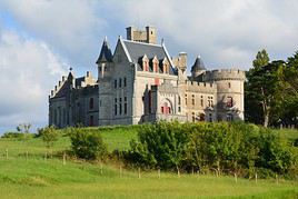
Château d'Abbadia, Hendaye, Pyrénées-Atlantiques, France
Abbadia Castle
It is both a large and charming "castle-museum" (scientific collections, furnishings, etc.) and, more broadly, a place to discover the natural environment of what is known as the Basque Corniche.

In the Surrounding Area

Bidart - San Sebastian Coastal Trail
Fifty-four kilometers of trails along the coast from Bidart to San Sebastian in Spain. Beautiful panoramic views throughout the route.

Climate and Weather in Hendaye

The area enjoys a cool, fairly windy oceanic climate. Summers are free from excessive heat thanks to the influence of the Atlantic Ocean, while winters are relatively mild, cloudy, and especially damp. The wettest periods are at the end and beginning of the year. Generally, the best time to visit climatically is June to September to avoid too much rain.

Sea Temperature Throughout the Year

Jan.Feb.Mar.Apr.MayJun.Jul.Aug.Sep.Oct.Nov.Dec.
Hendaye111111121416182018171412

Transportation

Getting There

Getting Around

Accommodation

Dining

Useful Addresses

Further Information

View guide page: Hendaye

Abbadia Castle

It is both a large and charming "castle-museum" (scientific collections, furnishings, etc.) and, more broadly, a place to discover the natural environment of what is known as the Basque Corniche.

Overview of the castle

It is both a large and charming "castle-museum" (scientific collections, furnishings, etc.) and, more broadly, a place to discover the natural environment of what is known as the Basque Corniche.

  • Tourist interest: (worth seeing).

History of Abbadia Castle

What to see and do

Practical information

  • Location:
  • Local time: Heure : 22061.
  • Address: Corniche Road, 64700 Hendaye.
  • Opening hours:
  • Price:

Transport

Accommodation and dining

What to see nearby

  1. == En complément
View guide page: Abbadia Castle

Oloron Sainte-Marie

The "capital" of Haut-Béarn, built along the river gave, serves as a gateway to the Pyrénées National Park.

Overview of Oloron Sainte-Marie

The "capital" of Haut-Béarn, built along the river gave, serves as a gateway to Pyrénées National Park.

Key facts

  • Type of place: small town.
  • Tourist interest: (worth a stop if you are in the area).
  • Location:
  • Distances:
  • Local time: Heure : 19335.
  • Population: 10,824 inhabitants (2014)
  • Area: 68.31 km².
  • Altitude: from 194 to 1,280 m.

History of Oloron Sainte-Marie

Climate and weather

What to see and do

In the surrounding area

Getting around

How to get there

How to get around

Where to stay

Where to eat

Useful addresses

  1. == Additional information
View guide page: Oloron Sainte-Marie

Orthez

This town of around 10,000 inhabitants has a few remnants of its medieval past.

Overview of Orthez

This town of just over 10,000 inhabitants has a few remnants of its medieval past.

Key Facts

  • Type of place: small town.
  • Tourist interest: (worth a stop if you are in the area).
  • Location:
  • Distances:
  • Local time: Heure : 19336.
  • Population: 10,722 inhabitants (2014).
  • Area: 45 km².
  • Altitude: from 38 to 185 m.

History of Orthez

Climate and Weather in Orthez

What to See and Do

In the Surrounding Area

Transport

Getting There

Getting Around

Accommodation

Food

Useful Addresses

Further Information

View guide page: Orthez

Pau

The city of Henri IV is primarily known for its castle. It is also the prefecture of the Pyrénées-Atlantiques. The city of Henri IV is primarily known for its castle. It is also the prefecture of the Pyrénées-Atlantiques. Type de lieu: city. Intérêt…

Read the full guide: Pau

Saint-Jean-de-Luz

Nestled in its bay, the town is both a fishing port and a well-known, slightly upscale seaside resort, as evidenced by some of the beautiful villas along its waterfront. Nestled in its bay, the town is both a fishing port and a well-known, slightly upscale…

Read the full guide: Saint-Jean-de-Luz

Salies-de-Béarn

This small town in the Gaves region has preserved its old stone houses and narrow streets.

Overview of Salies-de-Béarn

Salies-de-Béarn, a small town in the Gaves region, has preserved its old stone houses and narrow streets.

Key Facts

  • Type of place: small town.
  • Tourist interest: (worth a stop if you are in the area).
  • Location: in the Pyrénées-Atlantiques, on the route between Bayonne and Pau.
  • Distances:
  • Local time: Heure : 19339.
  • Population: 4,724 inhabitants (2014).
  • Area: 52.08 km².
  • Altitude: from 28 to 202 m.

History of Salies-de-Béarn

What to See and Do

A few old stone houses, narrow streets, and 19th-century thermal baths with an original façade make up the town’s main attractions.

Salt Museum and Béarn Traditions
This is an introduction to the region's economic and traditional activities.

In the Surrounding Area

Climate and Weather

Transportation

Getting There

Getting Around

Accommodation

Food

Useful Addresses

Further Information

View guide page: Salies-de-Béarn

Salt Museum and Béarn Traditions

This is an introduction to the region's economic and traditional activities.

Overview of the Museum

This is an introduction to the region's economic and traditional activities.

  • Tourist interest: (worth a stop if you are in the area).

History of the Museum

Collections on Display

Practical Information

  • Location:
  • Address: 15 rue des Puits Salants, 64270 Salies-de-Béarn.
  • Opening hours:
  • Price:
  • How to get there:

Nearby Attractions

  1. == In addition
View guide page: Salt Museum and Béarn Traditions

Espelette

Known for its red peppers, the small town also boasts beautiful Basque houses where strings of these same peppers dry at the end of the year.

Overview of Espelette

Known for its red peppers, the small town of Espelette also boasts beautiful Basque houses where strings of these same peppers dry at the end of the year.

Key Facts

  • Type de lieu: village.
  • Intérêt touristique: (worth a stop if you are in the area).
  • Localisation: in the Pyrénées-Atlantiques department, south of Bayonne.
  • Distances:
  • Heure locale: Heure : 19354.
  • Population: 2,101 inhabitants (2014).
  • Superficie: 26.85 km².
  • Altitude: from 33 to 749 m.

History of Espelette

What to See and Do in Espelette

Like many others in the region, the town has beautiful Basque houses where strings of the famous Espelette pepper dry at the end of the year.

Espelette Pepper Showcase
This is essentially the "museum" of the Espelette pepper, created by the Espelette Pepper Producers' Union.

In the Surrounding Area

Climate and Weather in Espelette

Transportation

Getting There

Getting Around

Accommodation

Dining

Useful Addresses

Further Information

View guide page: Espelette

Espelette Pepper Showcase

This is essentially the "museum" of the Espelette pepper, created by the Espelette Pepper Producers' Union.

Overview of the Site

This is essentially the "museum" of the Espelette pepper, created by the Espelette Pepper Producers' Union of Espelette.

  • Tourist interest: (worth a stop if you are in the area).

Museum History

Exhibits

Practical Information

  • Location:
  • Address: 25 Merkatu Plaza, 64250 Espelette.
  • Opening hours:
  • Price:
  • How to get there:

Nearby Attractions

  1. == In addition
View guide page: Espelette Pepper Showcase

Isturitz and Oxocelhaya Caves

These are two prehistoric decorated caves.

Overview of the caves

These are two prehistoric decorated caves in the Basque Country.

  • Tourist interest: (worth a stop if you are in the area).
  • Features: decorated caves.
  • Area:

Cave layout

What to see and do

Practical information

  • Location:
  • Address: Herebehere District, 64640 Saint-Martin-d'Arberoue.
  • Opening hours:
  • Price:
  • How to get there:
  • Distances:

Sleeping and eating

Nearby attractions

  1. == In addition
View guide page: Isturitz and Oxocelhaya Caves

Barétous Valley

Forests and mountains on the border of Béarn and the Basque Country.

Overview of the valley

This is a region of forests and mountains on the border of Béarn and the Basque Country.

  • Tourist interest: (worth seeing).
  • Features:
  • Length:
  • Altitude:

Valley environment

Wildlife and flora

Climate and weather

Precautions

What to see and do

Practical information

  • Location:
  • How to get there:
  • Distances:

Getting around

Accommodation and dining

What to see nearby

  1. == En complément
View guide page: Barétous Valley

Basque Country (France)

This is the western part of the department (which extends 80% into Spain), known for its strong culture and distinct traditions.

Overview of the Basque Country

This is the western part of the Pyrénées-Atlantiques department (which extends 80% into Spain), known for its strong culture and distinct traditions.

Key Facts

  • Type of place: tourist region.
  • Tourist interest: (recommended).
  • Location:
  • Local time: Heure : 21853
  • Population:
  • Area:
  • Highest point:
  • Lowest point: sea level.
  • Coastline:

History of the Basque Country

Climate and Weather

Main Cities

Tourist Attractions

Cities and Heritage

Beaches and Seaside

Nature and Activities

Transportation

Getting There

Getting Around

Accommodation

Food

Further Reading

View guide page: Basque Country (France)

La Bastide-Clairence

One of the many "white and red" villages typical of the Basque Country. It is part of the "Most Beautiful Villages of France".

Overview of La Bastide-Clairence

La Bastide-Clairence is one of the many "white and red" villages typical of the Basque Country. It is part of the "Most Beautiful Villages of France".

Key Facts

  • Type of place: village.
  • Tourist interest: (worth a stop if you are in the area).
  • Location: in the Pyrénées-Atlantiques department, between Bayonne and Pau.
  • Distances:
  • Local time: Heure : 22035.
  • Population: 1,016 inhabitants (2014).
  • Area: 23.39 km².
  • Altitude: from 7 to 192 m.

History of La Bastide-Clairence

What to See and Do

Like many other villages in the area, La Bastide has charming white-and-red-fronted houses, typical of the Basque Country.

Jewish Cemetery of La Bastide-Clairence
Around sixty tombs dating from the 17th and 18th centuries, belonging to Jewish families who settled in the village after fleeing the Inquisition in Spain and Portugal.

In the Surrounding Area

Climate and Weather

Transport

Getting There

Getting Around

Accommodation

Food

Useful Addresses

Further Information

View guide page: La Bastide-Clairence

Jewish Cemetery of La Bastide-Clairence

Around sixty tombs dating from the 17th and 18th centuries, belonging to Jewish families who settled in the village after fleeing the Inquisition in Spain and Portugal.

Overview of the site

Around sixty tombs dating from the 17th and 18th centuries, belonging to Jewish families who settled in the village after fleeing the Inquisition in Spain and Portugal.

  • Tourist interest: (worth a stop if you are in the area).

History of the cemetery

What to see and do

Practical information

  • Location:
  • Address: 64240 La Bastide-Clairence.
  • Opening hours:
  • Price:
  • Website:
  • How to get there:

What to see nearby

  1. == In addition
View guide page: Jewish Cemetery of La Bastide-Clairence

Navarrenx

This medieval bastide is one of the oldest towns in Béarn, with its ramparts and a few old buildings.

Overview of Navarrenx

The medieval bastide of Navarrenx is one of the oldest towns in Béarn, with its ramparts and a few old buildings.

Key Facts

  • Type of place: village.
  • Tourist interest: (worth seeing).
  • Location: in the Pyrénées-Atlantiques department (Béarn), not far from Pau.
  • Distances:
  • Local time: Heure : 22036.
  • Population: 1,047 inhabitants (2014).
  • Area: 6.21 km².
  • Altitude: from 118 to 269 m.

History of Navarrenx

What to See and Do in Navarrenx

With its 16th-century fortifications, this bastide in Béarn has a distinct charm, complemented by a few old buildings within its walls.

Navarrenx Cigar House
The town produces cigars. At the village factory, you can discover the history of tobacco in the region and meet the rollers (Cuban) who produce around a hundred cigars each day.

In the Surrounding Area

Climate and Weather in Navarrenx

Transportation

Getting There

Getting Around

Accommodation

Dining

Useful Addresses

Further Information

View guide page: Navarrenx

Navarrenx Cigar House

The town produces cigars. At the village factory, you can discover the history of tobacco in the region and meet the rollers (Cuban) who produce around a hundred cigars each day.

Overview

The town produces cigars. At the village factory, you can discover the history of tobacco in the region and meet the rollers (Cuban) who produce around a hundred cigars each day.

  • Tourist interest: (worth a stop if you are in the area).

History of the Navarrenx Cigar House

Exhibitions, activities and events

Practical information

  • Location:
  • Opening hours:
  • Rates:
  • How to get there:

Nearby

View guide page: Navarrenx Cigar House

Saint-Jean-Pied-de-Port

This small town on the Camino de Santiago boasts a rich military heritage with its citadel, as well as civil and religious landmarks. It is listed among the "Most Beautiful Villages of France."

Overview of Saint-Jean-Pied-de-Port

Saint-Jean-Pied-de-Port is located on the Ways of Saint-Jacques-de-Compostela. It boasts a rich military heritage with its citadel, as well as civil and religious landmarks. The town is listed among the "Most Beautiful Villages of France."

Key Facts

  • Type of place: village.
  • Tourist interest: (worth seeing).
  • Location: in the south of the Pyrénées-Atlantiques department, not far from the Spain.
  • Distances:
  • Local time: Heure : 22037.
  • Population: 1,553 inhabitants (2014).
  • Area: 2.73 km².
  • Altitude: from 159 to 320 m.

History of Saint-Jean-Pied-de-Port

What to See and Do

Along the banks of the Nive River, the town center is home to many beautiful traditional houses with red and white façades. The citadel and its redoubt (17th century) stand as reminders of the town’s military past.

In the Surrounding Area

Climate and Weather

Transportation

Getting There

Getting Around

Accommodation

Dining

Useful Addresses

Further Information

View guide page: Saint-Jean-Pied-de-Port

Sare

Known as the starting point for the little train up La Rhune, the town also boasts beautiful Basque architecture.

Overview of Sare

Sare is known as the starting point for the little train up La Rhune. The town also boasts beautiful Basque architecture.

Key Facts

  • Type of place: small town.
  • Tourist interest: (worth a stop if you are in the area).
  • Location: in the Pyrénées-Atlantiques department, on the border with Spain.
  • Distances:
  • Local time: Heure : 22038.
  • Population: 2,596 inhabitants (2014)
  • Area: 51.34 km².
  • Altitude: from 27 to 881 m.

History of Sare

What to See and Do in Sare

Set against the foothills of the Pyrenees, the town offers beautiful architecture typical of the region, as seen in the "Ortillopitz" house-museum.

Prehistoric Caves of Sare
These are 900 m of underground galleries fitted out with sound and light for visits, a dedicated museum, a megalithic reconstruction park, and a caving school.
Basque Cake Museum
A guided tour exploring the history, taste, and flavors of the famous Basque Cake.
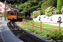
Petit train de la Rhune, Sare, Pyrénées-Atlantiques, France
Little Train of La Rhune
A small rack railway to La Rhune (905 m), the summit of the Basque Country, offering a magnificent panorama. A 35-minute journey through wild nature where the famous pottok (small Basque ponies) roam freely.

In the Surrounding Area

Climate and Weather in Sare

Transport

Getting There

Getting Around

Accommodation

Eating Out

Useful Addresses

Further Information

View guide page: Sare

Basque Cake Museum

A guided tour exploring the history, taste, and flavors of the famous Basque Cake.

Overview of the Museum

This is a guided tour exploring the history, taste, and flavors of the famous Basque Cake.

  • Tourist interest: (worth a stop if you are in the area).

Museum History

Exhibits

Practical Information

  • Location:
  • Address: Maison Haranea, D406, 64310 Sare.
  • Opening hours:
  • Price:
  • How to get there:

Nearby Attractions

  1. == In addition
View guide page: Basque Cake Museum

Little Train of La Rhune

A small rack railway to La Rhune (905 m), the summit of the Basque Country, offering a magnificent panorama. A 35-minute journey through wild nature where the famous pottok (small Basque ponies) roam freely.

Overview of the Little Train of La Rhune

This is a small rack railway to La Rhune (905 m), the summit of the Basque Country, offering a magnificent panorama. A 35-minute journey through wild nature where the famous pottok (small Basque ponies) roam freely.

Key Details

  • Type of place: tourist train.
  • Tourist interest: (recommended).
  • Theme:
  • Location:
  • Local time: Heure : 22040
  • Main towns:
  • Length:
  • Altitude:

The Line

Route

What to See and Do

Nearby

Climate and Weather

Sleep and Eat

Additional Information

View guide page: Little Train of La Rhune

Prehistoric Caves of Sare

These are 900 m of underground galleries fitted out with sound and light for visits, a dedicated museum, a megalithic reconstruction park, and a caving school.

Overview of the Caves

These are 900 m of underground galleries fitted out with sound and light for visits, a dedicated museum, a megalithic reconstruction park, and a caving school.

  • Tourist interest: (worth seeing).
  • Features: developed caves.
  • Area:

Cave Layout

What to See and Do

Practical Information

  • Location:
  • Address: Lezea, 64310 Sare.
  • Opening hours:
  • Price:
  • How to get there:
  • Distances:

Sleeping and Eating

Nearby Attractions

  1. == En complément
View guide page: Prehistoric Caves of Sare

Something wrong or out of date? Report this page