Skip to content
Southern Portugal

Travel guide · Portugal

Southern Portugal

★ 3 · last edited Jun 23, 2020 · 2 versions

Neighbouring Andalusia, Faro and its surroundings are one of Europe's most important summer tourist regions. Beyond its historically interesting heritage and beautiful natural setting in the southwest (Alentejo Park and Costa Vicentina), it is primarily the beaches and numerous seaside resorts that attract millions of tourists each year, mostly from the United Kingdom, Germany, or Scandinavia.

Overview

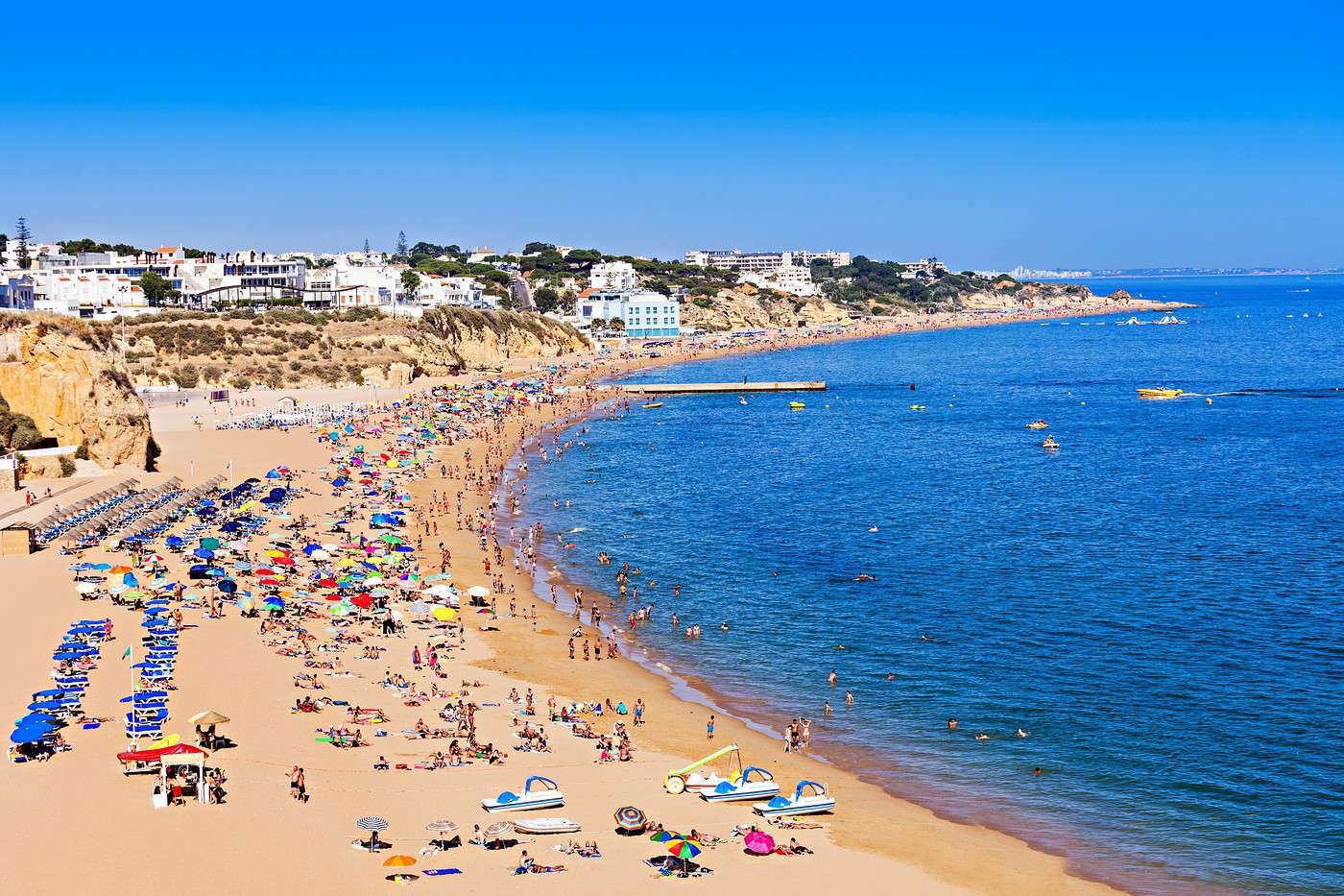
Albufeira, Portugal
Albufeira, Portugal · © VoyageForum

Neighbouring Andalusia, Faro and its surroundings are one of Europe's most important summer tourist regions. Beyond its historically interesting heritage and beautiful natural setting in the southwest (Alentejo Park and Costa Vicentina), it is primarily the beaches and numerous seaside resorts that attract millions of tourists each year, mostly from the United Kingdom, Germany, or Scandinavia.

Main towns

Tourist attractions

Towns and their heritage

Beaches and coastline

Nature and activities

Climate and weather

Albufeira

The former fishing village has transformed into a bustling seaside resort, lively (its main appeal) and rather upscale. The former fishing village has transformed into a bustling seaside resort, lively (its main appeal) and rather upscale. Type de lieu: small…

Read the full guide: Albufeira

Beja

A medium-sized town in southern Portugal with several museums and a medieval castle.

Overview of Beja

A medium-sized town in southern Portugal with several museums and a medieval castle.

Key Details

  • Type of place: small town.
  • Tourist interest: (worth a stop if you are in the area).
  • Location:
  • Distances:
  • Local time: Heure : 4341.
  • Population: 35,854 (2012).
  • Area: 1,140 km².
  • Altitude:
  • Website:

History of Beja

What to See and Do in Beja

In the Surrounding Area

Climate and Weather in Beja

Transportation

Getting There

Getting Around

Accommodation

Food

Useful Addresses

  1. == Additional Information
View guide page: Beja

Castro Marim

On the Spanish border, this ancient town boasts a medieval fortress. It is surrounded by marshes designated as a nature reserve. Several beaches nearby.

Overview of Castro Marim

On the Spanish border, this ancient town boasts a medieval fortress. It is surrounded by marshes designated as a nature reserve. Several beaches nearby.

Key facts

  • Type of place: small town.
  • Tourist interest: (worth a stop if you are in the area).
  • Location:
  • Distances:
  • Local time: Heure : 4342.
  • Population: 6,747 (2012).
  • Area: 299.83 km².
  • Altitude:
  • Website:

History of Castro Marim

What to see and do in Castro Marim

In the area

Climate and weather in Castro Marim

Transport

Getting there

Getting around

Accommodation

Eating

Useful addresses

Further information

View guide page: Castro Marim

Faro

Capital of the Algarve, Faro is primarily the airport gateway for millions of holidaymakers heading to southern Portugal. Nevertheless, the city also boasts some historic buildings, nearby beaches, and a nature reserve on its outskirts. Église do Carmo, Faro,…

Read the full guide: Faro

Lagoa

An area of beautiful beaches (and occasional cliffs) between Albufeira and Portimão. Several churches, convents, and old forts in the surrounding area.

Overview of Lagoa

This is an area of beautiful beaches (and occasional cliffs) between Albufeira and Portimão. Several churches, convents, and old forts are worth seeing in the surrounding area.

Key Facts

  • Type of place: small town.
  • Tourist interest: (worth seeing).
  • Location:
  • Distances:
  • Local time: Heure : 4344.
  • Population: 22,975 inhabitants (2012).
  • Area: 88.50 km².
  • Altitude: sea level.
  • Website:

History of Lagoa

What to See and Do in Lagoa

In the Surrounding Area

Climate and Weather in Lagoa

The city enjoys a Mediterranean climate influenced by the Gulf Stream. Winters are mild and humid, while summers are hot and sunny (the Algarve is the sunniest region in Portugal).

Sea Temperature Throughout the Year

Jan.Feb.Mar.Apr.MayJun.Jul.Aug.Sep.Oct.Nov.Dec.
Lagoa151515161718202120191816

Transportation

Getting There

Getting Around

Accommodation

Dining

Useful Addresses

Additional Information

View guide page: Lagoa

Lagos (Portugal)

Located almost at the southwestern tip of the country, Lagos offers lovely beaches, beautiful architecture, and a rich historical heritage. You can also take scenic boat trips to explore its cliffs.

Overview of Lagos

Located almost at the southwestern tip of the country, Lagos offers lovely beaches, beautiful architecture, and a rich historical heritage. You can also take scenic boat trips to explore its cliffs.

Key facts

  • Type of place: small town.
  • Tourist interest: (worth seeing).
  • Location:
  • Distances:
  • Local time: Heure : 4345.
  • Population: 31,049 inhabitants (2012).
  • Area: 213.92 km².
  • Altitude: sea level.

History of Lagos

What to see and do in Lagos

In the surrounding area

Climate and weather in Lagos

The city enjoys a Mediterranean climate influenced by the Gulf Stream. Winters are mild and humid, while summers are hot and sunny (the Algarve is the sunniest region in Portugal).

Sea temperature throughout the year

Jan.Feb.Mar.Apr.MayJun.Jul.Aug.Sep.Oct.Nov.Dec.
Lagos151515161718202120191816

Transport

Getting there

Getting around

Accommodation

Food

Useful addresses

Further reading

View guide page: Lagos (Portugal)

Loulé

Slightly inland from the coast, the town features several churches and a hilltop castle overlooking the area. Nearby are renowned beaches and golf courses, including Quinta do Lago.

Overview of Loulé

Slightly inland from the coast, the town features several churches and a hilltop castle overlooking the area. Nearby are renowned beaches and golf courses, including Quinta do Lago.

Key facts

  • Type of place: city.
  • Tourist interest: (worth a stop if you are in the area).
  • Location:
  • Distances:
  • Local time: Heure : 4346.
  • Population: 70,622 inhabitants (2012).
  • Area: 764.2 km².
  • Altitude:

History of Loulé

What to see and do in Loulé

In the surrounding area

Climate and weather in Loulé

Transport

Getting there

Getting around

Where to stay

Where to eat

Useful addresses

Further information

View guide page: Loulé

Mértola

This small town with its medieval castle, churches, and ramparts is also a good base for exploring the Guadiana Valley Natural Park.

Overview of Mértola

This small town with its medieval castle, churches, and ramparts is also a good base for exploring Guadiana Valley Natural Park.

Key details

  • Type of place: small town.
  • Tourist interest: (worth seeing).
  • Location:
  • Distances:
  • Local time: Heure : 4347.
  • Population: 7,274 (2012).
  • Area: 1,279 km².
  • Altitude:

History of Mértola

What to see and do in Mértola

In the surrounding area

Climate and weather in Mértola

javascript:%20void(0);

Transportation

Getting there

Getting around

Accommodation

Eating

Useful addresses

Further information

View guide page: Mértola

Mirobriga

The remains of a Roman city located near Santiago do Cacém.

Overview of the site

The remains of a Roman city located near Santiago do Cacém.

  • Tourist interest: (worth a stop if you are in the area).
  • Features: Roman ruins.
  • Area:
  • Altitude: 226 m

History of the site

What to see

Practical information

  • Location:
  • Address: Herdade dos Chaos Salgados, 7540-236 Santiago do Cacém.
  • Opening hours:
  • Price:
  • Website:
  • How to get there:

What to see nearby

  1. == In addition
View guide page: Mirobriga

Monchique

In the hinterland, this large traditional village at a slightly elevated altitude serves as a starting point for hikes in the surrounding area or to the nearby thermal village of Caldas.

Overview of Monchique

In the hinterland, this large traditional village at a slightly elevated altitude serves as a starting point for hikes in the surrounding area or to the nearby thermal village of Caldas.

Key Information

  • Type of place: small town.
  • Tourist interest: (worth a stop if you are in the area).
  • Location:
  • Distances:
  • Local time: Heure : 4349.
  • Population: 6,045 inhabitants (2012).
  • Area: 395.30 km².
  • Altitude:

History of Monchique

What to See and Do in Monchique

In the Surrounding Area

Climate and Weather in Monchique

Transportation

Getting There

Getting Around

Accommodation

Dining

Useful Addresses

  1. == Additional Information
View guide page: Monchique

Portimão

The second city of the Algarve, this traditionally fishing-oriented town is now known for its beach and sporting events (surfing, regattas, F1). Nearby, Alvor and Carvoeiro are also quite tourist-friendly.

Overview of Portimão

The second city of the Algarve, this traditionally fishing-oriented town is now known for its beach and sporting events (surfing, regattas, F1). Nearby, the towns of Alvor and Carvoeiro are also quite tourist-friendly.

Key Facts

  • Type of place: city.
  • Tourist interest: (worth a stop if you are in the area).
  • Location:
  • Distances:
  • Local time: Heure : 4350.
  • Population: 55,614 (2012).
  • Area: 182 km².
  • Altitude: sea level.

History of Portimão

What to See and Do in Portimão

In the Surrounding Area

Climate and Weather in Portimão

The city enjoys a Mediterranean climate influenced by the Gulf Stream. Winters are mild and humid, while summers are hot and sunny (the Algarve is the sunniest region in Portugal).

Sea Temperature Throughout the Year

Jan.Feb.Mar.Apr.MayJun.Jul.Aug.Sep.Oct.Nov.Dec.
Portimão151515161718202120191816

Transportation

Getting There

Getting Around

Accommodation

Dining

Useful Addresses

Additional Information

View guide page: Portimão

Porto Covo

On the southwest coast, this charming village with its 18th-century buildings and nearby small forts is very popular in season for its beaches.

Overview of Porto Covo

On the southwest coast, this charming village with its 18th-century buildings and nearby small forts is very popular in season for its beaches.

Key details

  • Type of place: village.
  • Tourist interest: (worth seeing).
  • Location:
  • Distances:
  • Local time: Heure : 4351.
  • Population: 1,038 (2012).
  • Area: 50.72 km².
  • Altitude: sea level.
  • Website:

History of Porto Covo

What to see and do in Porto Covo

In the surrounding area

Climate and weather in Porto Covo

Transport

Getting there

Getting around

Accommodation

Food

Useful addresses

  1. == Additional information
View guide page: Porto Covo

Salema

At the southwestern tip, a fishing village with fairly quiet beaches. You can hike along the cliffs in the surrounding area.

Overview of Salema

Located at the southwestern tip of the Algarve, this is a fishing village with fairly quiet beaches. You can hike along the cliffs in the surrounding area.

Key Details

  • Type of place: village.
  • Tourist interest: (worth seeing).
  • Location:
  • Distances:
  • Local time: Heure : 4352.
  • Population:
  • Area:
  • Altitude: sea level.
  • Website:

History of Salema

What to See and Do in Salema

In the Surrounding Area

Climate and Weather in Salema

Transportation

Getting There

Getting Around

Accommodation

Dining

Useful Addresses

  1. == Additional Information
View guide page: Salema

Silves

West of Faro, the city has one of the region’s prettiest old centres, featuring a beautiful cathedral and an ancient Moorish fortress surrounded by walls.

Overview of Silves

West of Faro, the city boasts one of the region’s prettiest old centres, with a stunning cathedral and an ancient Moorish fortress surrounded by walls.

Key facts

  • Type of place: small town.
  • Tourist interest: (recommended).
  • Location:
  • Distances:
  • Local time: Heure : 4353.
  • Population: 37,126 inhabitants (2012).
  • Area: 678.75 km².
  • Altitude:

History of Silves

What to see and do in Silves

In the area

Climate and weather in Silves

Transport

Getting there

Getting around

Accommodation

Food

Useful addresses

Further information

View guide page: Silves

Sines

On the coast between Lisbon and the Algarve, the small port where Vasco da Gama was born features an old quarter and a fortress.

Overview of Sines

On the coast, between Lisbon and the Algarve, the small port where Vasco da Gama was born features an old quarter and a fortress.

Key Facts

  • Type of place: small town.
  • Tourist interest: (worth a stop if you are in the area).
  • Location:
  • Distances:
  • Local time: Heure : 4354.
  • Population: 18,298 (2015).
  • Area: 198.97 km².
  • Altitude: sea level.
  • Website:

History of Sines

What to See and Do in Sines

In the Surrounding Area

Climate and Weather in Sines

Transportation

Getting There

Getting Around

Accommodation

Dining

Useful Addresses

  1. == Additional Information
View guide page: Sines

Tavira

A charming town with partly 18th-century architecture that can serve as a gateway to the Ria Formosa Natural Park and nearby beaches.

Overview of Tavira

A charming town with partly 18th-century architecture that can serve as a gateway to the Ria Formosa Natural Park and nearby beaches.

Key Facts

  • Type of place: small town.
  • Tourist interest: (worth seeing).
  • Location:
  • Distances:
  • Local time: Heure : 4355.
  • Population: 26,167 inhabitants (2012).
  • Area: 607.17 km².
  • Altitude: sea level.

History of Tavira

What to See and Do in Tavira

In the Surrounding Area

Climate and Weather in Tavira

The town enjoys a Mediterranean climate influenced by the Gulf Stream. Winters are mild and humid, while summers are hot and sunny (the Algarve is the sunniest region in Portugal).

Transportation

Getting There

Getting Around

Accommodation

Dining

Useful Addresses

Further Information

View guide page: Tavira

Vilamoura

One of Europe’s largest beach and tourist resorts, located west of Faro near Quarteira. A few Roman ruins amid it all.

Overview of Vilamoura

One of Europe’s largest beach and tourist resorts, located west of Faro near Quarteira. A few Roman ruins amid it all.

Key facts

  • Type of place: small town.
  • Tourist interest: (worth a stop if you are in the area).
  • Location:
  • Distances:
  • Local time: Heure : 4356.
  • Population:
  • Area:
  • Altitude: sea level.

History of Vilamoura

What to see and do in Vilamoura

In the surrounding area

Climate and weather in Vilamoura

The town enjoys a Mediterranean climate influenced by the Gulf Stream. Winters are mild and humid, while summers are hot and sunny (the Algarve is the sunniest region in Portugal).

Sea temperature throughout the year

Jan.Feb.Mar.Apr.MayJun.Jul.Aug.Sep.Oct.Nov.Dec.
Vilamoura151515161718202120191816

Transport

Getting there

Getting around

Accommodation

Food

Useful addresses

Further reading

View guide page: Vilamoura

Southwest Alentejo and Vicentine Coast Natural Park

Stretching over 100 kilometres, this terrestrial and marine park offers stunning landscapes with a succession of beaches and cliffs. It is renowned for its ornithology and is home to Cape St. Vincent, the southwesternmost point of Europe. You can hike here via the "Rota Vicentina" (Vicentine Route).

Overview of the park

Stretching over 100 kilometres, this terrestrial and marine park offers stunning landscapes with a succession of beaches and cliffs. It is renowned for its ornithology. It is also home to Cape St. Vincent, the southwesternmost point of Europe. You can hike here via the "Rota Vicentina" (Vicentine Route).

  • Tourist interest: (must-see or highly recommended).
  • Features:
  • Area: 744 km².
  • Altitude: sea level.

Environment

Park physiognomy

Wildlife and flora

Climate and weather

Precautions

What to see

What to do

Practical information

  • Location:
  • Opening period:
  • Website:
  • How to get there:
  • Distances:

Sleeping and eating

What to see nearby

Further information

View guide page: Southwest Alentejo and Vicentine Coast Natural Park

Ria Formosa Natural Park

Just outside Faro, this lagoon area is renowned for its birdlife. You can also take boat trips, enjoy the beaches, and visit some Roman ruins.

Overview of the park

Just outside Faro, this lagoon area is renowned for its birdlife. You can also take boat trips, enjoy the beaches, and visit some Roman ruins.

  • Tourist interest: (worth seeing).
  • Features:
  • Area: 184 km2.
  • Altitude: sea level.

Environment

Park landscape

Wildlife and flora

Climate and weather

Precautions

What to see

What to do

Practical information

  • Location:
  • Opening period:
  • How to get there:
  • Distances:

Sleeping and eating

What to see nearby

Further information
View guide page: Ria Formosa Natural Park

Guadiana Valley Natural Park

This large park near Spain offers quite pretty rolling landscapes with the added bonus of several waterfalls.

Overview of the park

This large park near Spain offers quite pretty rolling landscapes with the added bonus of several waterfalls.

  • Tourist interest: (worth a stop if you are in the area).
  • Features:
  • Area:
  • Altitude:

Environment

Park physiognomy

Wildlife and flora

Climate and weather

Precautions

What to see

What to do

Practical information

  • Location:
  • Opening period:
  • Website:
  • How to get there:
  • Distances:

Sleeping and eating

What to see nearby

  1. == In addition
View guide page: Guadiana Valley Natural Park

Caldas de Monchique

A thermal spa town (with a somewhat "overrated" tourist reputation) nestled in a valley near Monchique.

Overview of Caldas de Monchique

A thermal spa town (with a somewhat "overrated" tourist reputation) nestled in a valley near Monchique.

Key details

  • Type of place: village.
  • Tourist interest: (worth a stop if you are in the area).
  • Location:
  • Distances:
  • Local time: Heure : 20088.
  • Population:
  • Area:
  • Altitude: from 180 to 260 m.
  • Website:

History of Caldas de Monchique

What to see and do in Caldas de Monchique

In the surrounding area

Climate and weather in Caldas de Monchique

Transport

Getting there

Getting around

Accommodation

Food

Useful addresses

  1. == Additional information
View guide page: Caldas de Monchique

Sagres

The last town before Cape St. Vincent. You can visit its ancient fortress on the outskirts, overlooking the sea and cliffs.

Overview of Sagres

It’s the last town before Cape St. Vincent. You can visit its ancient fortress on the outskirts, which overlooks the sea and cliffs.

Key details

  • Type of place: village.
  • Tourist interest: (worth a stop if you are in the area).
  • Location:
  • Distances:
  • Local time: Heure : 20089.
  • Population: 1,909 (2012).
  • Area: 34.37 km².
  • Altitude: sea level.

History of Sagres

What to see and do in Sagres

In the surrounding area

Climate and weather in Sagres

Sea temperature throughout the year

Jan.Feb.Mar.Apr.MayJun.Jul.Aug.Sep.Oct.Nov.Dec.
Sagres151515161718202120191816

Transport

Getting there

Getting around

Accommodation

Eating

Useful addresses

Further reading

View guide page: Sagres

Something wrong or out of date? Report this page