Hi,
we’re planning a round trip from San Pedro de Atacama, Chile, to Salta, Argentina, in two months. On the way there, we’ll take the northern route via Susques, Route 27, then 52. But for the return, we were thinking of taking the southern route via San Antonio de los Cobres, Route 51, then 23. Is it similar to the northern route in terms of road surface? How busy is it, and are there gas stations? Basically, should we be worried about doing it in an SUV that’s supposedly 4x4 but has regular road tires and no second spare wheel, obviously...
I’ve seen that we can stop over in San Antonio de los Cobres.
Thanks for your feedback.
Raf.
Carnets : Namibie en camping car, l'Est de l'Afrique du Sud, du KTP au Kaokoland en 4x4, la Norvège en hiver 2x, l'Ecosse en hiver, la Namibie avec remorque, l'Islande en camping car en juin, le tout avec 4 enfants, dans le profil https://voyageforum.com/v.f?membre=Caperam;
Hi Caperam,
We can give you some info, especially about the Argentine side.
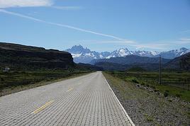
From the border, Route 52 is completely paved.
For gas stations, there’s one at the border,
2 in Susques (1 on Route 52 a few km before Susques and 1 small one in town that’s a bit hard to find).
After that, you won’t find any until Tilcara, 25 km from Purmamarca heading north on Route 9.
Otherwise, after Purmamarca on Route 9 toward Jujuy, the first one is in Yala, about 15 km before Jujuy.
Route 51 is paved up to San Antonio de los Cobres (with several sections of a few dozen meters where rain regularly washes away the road).
We passed through in November, but since then, there’s been heavy rain in the Puna that’s damaged it even more.
After San Antonio, it’s no longer paved at all and is quite rough.
We took it as far as Cauchari at the intersection with Provincial Route 27, which goes to Tolar Grande.
There’s quite a bit of traffic with pickups, trucks, and buses because of the mines and photovoltaic fields, and all these vehicles damage the road.
In San Antonio de los Cobres, there are 2 small gas pumps to refuel (as well as many hotels, hospedajes, and restaurants).
(6 km after San Antonio, you cross Route 40, where you can access the La Polvorilla viaduct—worth seeing if you’re in the area.)
We were in a Toyota Hilux pickup but only with two-wheel drive.
Best regards,
Hi, thanks for all the details. So, the southern route is indeed riskier than the northern one, especially with a car that’s not built for potentially tough sections. We’ve settled on a Hyundai Tucson 4x4, but it’s no Hilux.
So maybe a round trip on the same northern route... Something to think about.
Thanks.
Raf
Carnets : Namibie en camping car, l'Est de l'Afrique du Sud, du KTP au Kaokoland en 4x4, la Norvège en hiver 2x, l'Ecosse en hiver, la Namibie avec remorque, l'Islande en camping car en juin, le tout avec 4 enfants, dans le profil https://voyageforum.com/v.f?membre=Caperam;
There’s no difficult section on Route 51 if the road is dry.
The toughest part we encountered was between San Antonio de los Cobres and the junction with Route 27 (we don’t know about the rest after that).
We said it was tough, but it’s still drivable.
But when it rains a lot, it becomes a whole different story.
Best regards
Update.
We ended up doing the round trip on the same route, meaning the northern route, the easiest one. For gas, no issues with the current tanks—the Susques station only takes cash, but it’s not essential to fill up there since you can make it from San Pedro de Atacama to Tilcara without any problems. We had a hybrid SUV that only consumed 5 L per 100 km, but I still had half a tank left.
Carnets : Namibie en camping car, l'Est de l'Afrique du Sud, du KTP au Kaokoland en 4x4, la Norvège en hiver 2x, l'Ecosse en hiver, la Namibie avec remorque, l'Islande en camping car en juin, le tout avec 4 enfants, dans le profil https://voyageforum.com/v.f?membre=Caperam;