Results for "plateaux+|+99+>+86"
13401 results found.
Quel budget pour 4 semaines au Vietnam cet été? English translation pending
Je n'ai aucune idée des prix pratiqués là-bas. Qui pourrait me donner quelques indications récentes en terme de prix, notamment transports, bus, train ? du Nord au Sud. Hotels ? sachant que je ne recherche pas vraiment du luxe, mais un minimum de confort et de propreté quand même. Restos ? Bref, avec combien faut-il partir en poche pour ne pas se trouver à cours ?
Merci de vos tuyaux
Patrick
Merci de vos tuyaux
Patrick
Quel pays choisir en Amérique du Sud? English translation pending
Salut à tous,
Je suis tout l"été en vacances et désire faire un voyage en amérique du sud (4-5 sem.). Ma blonde est allé au Pérou l'an passé et elle a adoré son voyage mais je ne voudrais pas repasser dans ses traces.
Un ami vénézuelien me suggère l'Équateur, la Bolivie, l'Uruguay qui selon lui sont des pays où il ne coûte pas cher à voyager et que les gens sont chaleureux. Je voyagerai seul (ma blonde travaille) et désire voir du pays sans que ça coûte une fortune (transport en commun, camping, petit auberge pas chère etc.).
Alors, avec toute l'expérience des gens sur le réseau, il y a sûrement quelqu'un qui a une bonne suggestion ou un petit conseil à partager.
Merci!
ciao
Je suis tout l"été en vacances et désire faire un voyage en amérique du sud (4-5 sem.). Ma blonde est allé au Pérou l'an passé et elle a adoré son voyage mais je ne voudrais pas repasser dans ses traces.
Un ami vénézuelien me suggère l'Équateur, la Bolivie, l'Uruguay qui selon lui sont des pays où il ne coûte pas cher à voyager et que les gens sont chaleureux. Je voyagerai seul (ma blonde travaille) et désire voir du pays sans que ça coûte une fortune (transport en commun, camping, petit auberge pas chère etc.).
Alors, avec toute l'expérience des gens sur le réseau, il y a sûrement quelqu'un qui a une bonne suggestion ou un petit conseil à partager.
Merci!
ciao
Vietnam du Sud au Nord, quel transport utiliser? English translation pending
Nous sommes au Vietnam du 24 mars 04 au 30 avril 04 et nous voulons monter de Saigon a Hanoi avec nos 2 enfants(6 et 9), bus, train.voiture avec chauffeur...?
Playa pesquero English translation pending
Je pars pour Holguin à playa pesquero le 31 janvier et je voudrais savoir si on peux marcher longuement sur la plage et si l'animation est bonne (Géo, Discothèque, spectacle en soirée)?😏
2 semaines à Madagascar English translation pending
je voudrais aller à madagascar fin aout pour 2 semaines
j'aime marcher, découvrir la nature et les gens
je pense qu'en 2 semaines, il faut se contenter d'une petite partie de l'île
que me conseillez-vous?
j'aime marcher, découvrir la nature et les gens
je pense qu'en 2 semaines, il faut se contenter d'une petite partie de l'île
que me conseillez-vous?
Tibet: épopée très longue avec photos English translation pending
En fait avec Marsu (c Ivo qui ecrit la), on a ete faire un tour au Tibet, et on s'est dit qu'on allait raconter toutes ces belles choses. Alors on s'est laisse aller sur un clavier, il y a 6 pages. On espere que ca va vous plaire, et surtout vous donner envie d'aller faire un tour sur le pays du toit du monde.
Un rayon matinal éclaire doucement les terrasses de la vallée de KTM. Le vert éclatant mélangé aux couleurs dorées des tiges de riz coupées accompagnent notre regard sur la longue route menant à la terre interdite du Tibet. Nos corps ballottés de tous côtés sentent à peine les vibrations du bus tellement nos sens sont en éveil. Partout où notre regard se pose, nos yeux volent un instant de vie, captent un geste, un sourire, une moue pleine de rides jetant un regard tendre sur un petit enfant. Le travail des champs ne peux attendre, le riz doit être battu. D’un mouvement habile une femme au corps velouté dans son sari chatoyant, fait tournoyer autour de sa tête un long bâton, qu’elle abat de manière régulière sur les gerbes de riz posées a ses pieds. Mouvement lent, langoureusement rythmé, simplement naturel.
C’est le début du voyage, on a oublié la course poursuite dans Thamel, les taxis, la poussière, les combats de klaxons, les Tata imposants dans la lumière matinale, l’agitation qui les entoure, les visages curieux fixés sur les quelques occidentaux que nous sommes. Le Tata, c’est un monstre moderne qui trimballe les voyageurs et la marchandise, qui passe partout ou presque, coloré et chromé, au klaxon puissant, moyen de transport fonctionnel et multiforme, qui s’impose par sa présence à l’arrêt comme sur la route.
Des gens partout, sur les sièges, debout dans la travée, assis sur le toit, des hommes au teint couleur terre, des femmes portant des tissus aux milles nuances, des enfants souriants dans le vide, nous détaillant. Ce sont pour la plupart des gens de la terre, aux paniers chargés et aux mains calleuses, qui voyagent à travers le pays. L’aide du chauffeur, qui fait office de contrôleur, rameute les voyageurs en criant par la porte entrouverte, accroché d’une main, penché au dessus de la route. Il monte sur le toit pour encaisser le trajet, les billets croisés entre ses doigts, tape du poing sur la cabine pour signifier les arrêts au chauffeur, siffle pour aider à la manœuvre dans les parties délicates. Il est jeune et agile, son visage et lisse et souriant, il a de la prestance lorsqu’il se glisse par la porte. À l’approche d’un village, une jeune fille s’apprête à descendre : elle est jeune aussi, porte une robe punjabi aux couleurs miroitantes, elle se tient à coté de la porte, ses cheveux longs lâchés brillent dans le courant d’air, elle tient son sac d’une main, se tenant de l’autre, son bras frôlant le visage du jeune qui regarde dehors. Le Tata file, loin dessous c’est la rivière, des parcelles de riz, devant un village s’approche. Klaxon tonitruant, on rentre a vive allure, le jeune tape du poing. Freinage brusque, balancement des corps dans tout le bus, le coude de la jeune fille vient frapper le visage du jeune. Dans le même élan, elle descend du bus, son bras tendu vient laisser une caresse douce sur la joue du garçon, avec tendresse, pour s’excuser du choc, et plus encore car tout deux sont jeunes, mais enfermés dans la rigueur d’une société. Une fois sortie, c’est le plus beau de ses sourires qu’elle lui offre. Témoignage d’une jeunesse cloîtrée qui demande à vivre, ailleurs que dans l’instant furtif.
Un nuage de poussière s’élève devant nous laissant passer un rayon de lumière qui éclaire les montagnes drues et arides. Les strates semblables à des coulées de lave forment les montagnes des plateaux tibétains. La lumière glisse langoureusement dans les sillons de l’érosion de la dernière saison des pluies.
On a changé de monde, même si on garde en tête la longue montée dans la gorge, la rivière plusieurs centaines de mètres en contre bas, les pentes escarpées et encore boisées, la piste sinueuse accrochée aux flancs, l’eau qui ruisselle sur la roche. À quel moment sont apparues les premières pierres, quand ont disparus arbres, bambous plantes, terre grasse? L’aridité prend le dessus, la poussière s’élève derrière le véhicule, et malgré les cahots, les yeux parcourent chaque détail de ce nouveau monde, de ce grand vide qui nous aspire, de cet instant sorti du néant des mémoires et de l’imagination. Le toit du monde est sec, recouvrant d’une toile bleue tendue vers l’infini des pierres semées par un petit Poucet errant depuis l’éternité, laissant à penser que ici tout est sans repères. Ce petit Poucet, c’est celui que vous croiserez au bord de la route, jouant avec une roue de vélo, tirant sur un mégot ou bien que vous apercevrez sous l’habit d’un petit berger fouettant un âne, dirigeant un troupeau de chèvres, flattant un yack. C’est peut être la petite fille venant vous voir dans un village avec sa petite figure sale, ses yeux noirs de profondeur, mais éclatants d’une beauté intérieure. Le petit Poucet, c’est celui qui marche au fond de vous, qui vous cherche.
Shigatse
À l’aurore, l’air est frais à 4200 mètres, les rayons de soleil bataillent doucement pour réchauffer les parcelles de terre gelée. L’immense allée de bowling de 987 mètres de long par 24 de large, flanquée de part et d’autre de boutiques en tous genres, se dresse devant nous en jurant dans le décor. Lorsqu’on jette un coup d’œil à l’intérieur, nos yeux se butent sur des locaux vides, derrières les belles devantures à la gloire du communisme, les dépotoirs s’accumulent. Les tibétains avec leur allure rustre et sans façons font presque vulgaires dans ce décor aseptisé, leur beauté naturelle rehaussée par les rouges, turquoises et ambres ornant leurs cheveux n’arrivant pas à compenser cette incongruité. Caché entre deux majestueuses devantures, un discret bouiboui pointe devant une bande de joyeux nomades jouant avec ardeur à un jeu de dés sans signification pour nous. Ils font peu cas de notre passage, l’attrait du jeu étant plus fort. Nos pas nous mènent de nouveau devant une grande allée, plus sobre, bordée de pèlerins aux coiffures complexes et aux habits divers. Les moulins tournent, les Om mani padme hum fusent et sous nos yeux éblouis par la forte lumière des couleurs ocres, blanches et jaunes, le monastère de TashiLompo s’élève fier et majestueux devant nous.
Le chemin des pèlerins parsemé d’arbres divers nous entraîne dans son sillage, à l’assaut d’une bâtisse orange feu, précédée d’un escalier pentu et glissant menant à une porte masquée d’une tenture. Dans le désordre, les pèlerins surgissent du passage, le visage composé en prosternations, les lèvres marmonnant les Om mani padme hum de façon incessante, aucune cohésion dans la descente, tout le monde se lance de manière désordonnée, concentrés dans leur dévotion. On attaque l’escalier essayant de se faire un chemin au travers des pèlerins, intrus que nous sommes, je ressens une forme de rejet, spécialement lorsque nous arrivons à l’intérieur et que je nous sens coincés entre l’énorme Bouddha de 26 mètres et les pèlerins qui sont tous à leur adoration. Impressionnée par le regard perçant de Bouddha et l’émotion de la ferveur des pèlerins, je suis assaillie d’un sentiment de gène et de voyeurisme, qui me pousse à contourner respectueusement par la gauche et avec humilité cette immense force de spiritualité pour retourner à ma place, au grand air.
Un groupe attire le regard, ils sont une dizaine entre enfants, adultes et le Monk de la famille. Ils tranchent parmi les autres avec leurs cheveux scintillants finement tressés, ornés de parures de turquoises et d’ambres pour les femmes. Les hommes portent entremêlés dans leur grosses tresses de minces fils rouges ou noirs qui attirent l’œil comme un aimant, parfois au centre un énorme anneau en os de yack est glissé dans l’enroulement complexe de leur chevelure. Les gros manteaux doublés en fourrure de yack sont portés avec élégance, leurs habits sont simples mais raffinés, nomades de l’est ils se doivent d’être à l’abris des intempéries et des vents violents, ils sont beaux, plein de prestance, se tiennent droit pour montrer qu’ils sont fiers de leurs origines. Une seule manche couvre leur corps tandis que l’autre est artistiquement nouée autour de la taille. Difficile de deviner leur forme sous ces épaisseurs mais on arrive tout de même à percevoir leur grâce.
Parmi eux une petite princesse des hauts plateaux virevolte en tous sens avec espièglerie comme tous les enfants de son âge. Un petit manteau de soie rose lui cintre la taille, tombant en cascade de froufrou sur ses frêles chevilles. Ses délicates tresses remontées comme ceux de la princesse Léa contraste avec les cheveux noirs de jais du reste de la troupe par un semblant de reflets blond-roux. Un sourire resplendissant d’innocence reste suspendu à ses lèvres pendant qu’elle titille sa grand-mère au regard attendri appuyée sur un bâton qui supporte le poids de son âge.
Contraste entre âge et innocence, entre technologie et temps passé, entre Occident et Asie qui se mélangent dans une même dévotion. À leur suite deux personnes arrivent pour continuer le pèlerinage, pour mettre les dissemblances plus en évidence. Une jeune fille aux habits modernes, jeans moulant, pull échancré, coupe stylé, tient dans une main le beurre de yack qui sert à entretenir le feu des offrandes. De l’autre, elle soutient avec tendresse une autre main, plus usée, plus foncée, plus marquée par la vie. Lorsqu’on lève les yeux sur cette main on découvre une femme sans âge, aux rides souriantes cachées derrière une grosse paire de lunettes sortie d’une autre époque. Elle prend son bol nacré usé par les années pour puiser l’eau de la fontaine sacrée tandis que la jeune fille utilise sans broncher une vieille bouteille de Pepsi machouillée pour exécuter le même geste.
Les pas résonnent dans les petites ruelles du monastère, nous voilà entourés de jeunes, de vieux, de tibétains sans âge. Des voix rauques, des yeux curieux, une odeur de yack rance emplit leur aura comme une deuxième peau. Le croisement Asie-Occident se soude, les sourires se font hésitants, puis plein de franchise à la limite de la rigolade de part et d’autre. Échange de mots via le guide, échange d’écriture, curiosité dans les deux camps. L’un essayant de prononcer tant bien que mal dans la langue de l’autre. Intérêt des différences, les piercing, les cheveux blonds, les bijoux lourds, les vêtements tout est susceptible d’attirer l’attention de l’autre sans permettre d’en comprendre les significations profondes. Jeunesse insouciante qui prend le temps de connaître l’autre, de lire au fond de lui pour y trouver ce qu’il y a de meilleur, qui porte une attention sincère sans arrière pensée. Les adieux sont émouvants, l’impression d’avoir touché un bout de vie, d’âme, d’avoir trouvé des amis sincères qui n’attendent rien d’autre qu’un sourire provenant du cœur.
La cœur lourd, la tête pleine de sourire, de joie on découvre sous un nuage de poussière la petite ville de Gyatse. Ici tout est simple et grandiose de simplicité. Pas de fioriture à l’essence chinoise, juste la simplicité tibétaine malgré l’imposant fort dominant la ville. Le monastère dégage une atmosphère de grandeur, de sérénité qui nous prend dans ses filets. Les murs noirs aux mille représentations de Bouddha nous clouent sur place, nos petites lampes arrivent à peine a rendre la splendeur du lieu. Les pèlerins profitent de cette parcelle de lumière pour vénérer avec encore plus d’émotion ce dieu de la générosité.
Lhassa
Cinq jours que nos corps subissent les contre coups de la piste défoncée que notre jeep suit sans fin. Un sourire éclaire tout a coup le visage de notre chauffeur sans nom car malgré nos efforts la communication est impossible. Un sourire parce que devant nous se dresse enfin Lhassa, le but ultime de cette longue route. On a eu beau se le faire dire, on a essayé de se préparer mentalement mais le choc est grand, Lhassa n’est pas le reflet d’une petite ville paisible avec un temple aux consonances magiques, nous ramenant aux textes féeriques de Henrich Harrer ou Alexandra David-Neel, flanqué au centre de la ville comme on l’imaginait. C’est la première ville du Tibet autonome où il y a le moins de tibétains, son centre et ses environs sont remplis de chinois, l’allure en est chinoise. Cachées derrière les grandes devantures de magasins à rayons vides de monde, se dressent les petites rues sinueuses et pleines de vie du quartier tibétain dans une ville dite tibétaine. Découvrir les grandes artères chinoises nous donne l’impression de vivre dans deux univers parallèles, où les longs trottoirs luisants sont habités par les nomades mendiants qui regardent devant eux les fringues des boutiques de luxe comme s’il s’agissait d’habits d’extra-terrestre.
Une petite porte s’ouvre sur un grand couloir à ciel ouvert, la pénombre se mélange à la fumée et semble nous envelopper dans un doux cocon . Une rumeur s’élève au loin presque indescriptible, un petit chant imperceptible, des mots éparses incompréhensibles, les mains rudes pleines de sillons, sales, presque sans forme, se tendent vers nous. Dans l’autre main dans un tourbillon incessant, un moulin à prière tourne presque sans effort comme si une force ultime aidait au roulement. Au bout de la voie une essence de pin s’insinue dans nos narines, des dizaines de pèlerins assis de façon éparse, en structure finie mais chaotique, tournent d’un même rythme lancinant leur moulins tout en répétant de manière imperceptible le chant de leurs offrandes. Leurs regards sont souriants et accueillants, nos pas glissent doucement entre eux comme si nous nous promenions sur un nuage, le bien-être s’emparent de nous, sans nous sentir intrus ou malvenus. Nous laissons nos regards se fondre dans leurs yeux malins où toute une vie tient. Leur peau mate, durcie par le soleil, recueille les mystères d’une vie de nomade perdu au milieu des plateaux vides et silencieux. Les mains tendues égrainant les chapelets nous dirigent avec bonté vers l’immense moulin à prière tourné avec ferveur par des doigts calleux. De nouveau la pénombre nous oblige a plisser les yeux pour voir et sentir au travers des effluves les pèlerins assis en rond autour des moines à la voix sourde entonnant les prières. Des sourires invitant nous attirent a l’intérieur pour un tour dans un autre monde…..
On touche le cœur du Tibet, celui des anciens et des fervents religieux, force tranquille et combien reposante quand on connaît l’histoire ensanglantée du pays. Ces gens, cette cours des miracles fantastique, leur nombre, le mouvement des moulins omniprésent dans les yeux, leur son dans les oreilles, le balancement des corps, les bouches qui ruminent et mâchent, glaviots et chicots. Rentrer dans ce lieu, c’est renouer avec le Tibet antique, avec ses couleurs et ses traditions religieuses : il y a un sentiment très fort a vivre cela, a sentir tous ces regards pointés sur soi, cette bienveillance dont ils sont chargés alors que nous sommes des intrus. La bâche qui recouvre l’assemblée devient une tenture, les chaudrons fument de thé salé, et partout tournent les moulins, les tissus sont des trônes, les cartons deviennent tapis, ils sont beaux de leur age, de leur saleté, de leur difformités, et nous, nous sommes choquant de notre modernité, de notre regard pacifique et si éloigné de ce qu’ils connaissent. Nous sommes bercés du son des moulins, de ce marmonnement sorti de ces nombreuses bouches, de ces regards encore et toujours fixés sur nous. Cette tranquillité qu’ils sont capables de transmettre, laminant tout ce que nous croyons savoir, sur nous, sur les autres. Mon souhait le plus profond a alors été de ressentir cela au plus profond de moi, d’être en communion avec cette assemblée, en paix avec moi même également, avec les raisons du voyage. Nous n’avons pas su comment décrire, transmettre cet instant, ou bien plutôt ces instant, si forts que nous y sommes revenus, de même que nous n’avons pas voulu trahir le bien-être et la confiance de ces pèlerins en prenant des images qui n’auraient été que des reflets vides de sens.
Soir
On roule depuis des heures, les kilomètres s’accumulent au ralenti, la vallée s’allonge loin devant nous, bordée de collines. Des collines devant, des montagnes derrières, des sommets posés sur l’infini du plateau tibétain. Nous sommes assis, le programme télé dans le pare-brise est différent de celui des vitres arrières et des portières, le ronronnement du moteur, les vibrations et les cahots encore et toujours sont les seuls éléments réels. Dehors, c’est l’explosion des teintes, le grand feu d’artifice pour notre retour dans les plaines du Népal, la route du retour que nous avions parcourue au petit matin il y a peu, vers l’avant, en direction de Lhassa. Les rivières sont sages, gelées dans leur lit, les berges blanches de glace sont le présage d’un hiver proche et rude, bloquant la route et les cols, isolant cette partie du monde sous une cloche de froidure. On se croirait sur Mars, la planète rouge, le sol parsemé de caillasses, de rochers, modulé par les glissements de terrain sur les pentes arides, aux lignes cassées par les empilements en équilibres sur les promontoires, et si ce n’était des ruines ou bien des troupeaux éparpillés, on pourrait croire toute vie absente. Il faut imaginer une sorte de couloir, le fond de vallée, qui s’étire langoureusement en de larges virages, cerné par une haute dentelle décharnée, accessible par des pentes empierrées, des talus abrupts. Ces broderies semblent avoir été arrachées par des doigts géants, déchirées d’un mouvement brusque, laissant des cicatrices dans chaque profil de la roche, ouvrant des brèches, déformant les strates colorées, remontant du plus profond de la terre des couleurs chaudes et douces. Le soleil couchant renforce la teinte qui se nuance à l’infini, palette magique et folle, oxyde de fer, érosion, terres soulevées durant des siècles, offertes en pâture aux éléments naturels, aujourd`hui spectacle magique pour touristes en mal de vie. L’homme comme nous le connaissons ne peut vivre ici, mais on ne s’étonne plus de trouver ses maisons colorées, ses troupeaux éparpillés dans les collines, des enfants marchant dans la poussière, un panier en osier sur le dos. On regarde avec normalité un chariot chargé, un tracteur transportant vers nulle part une quinzaine de personnes, un cavalier tendu sur sa montures, des bottes colorées aux pieds. Mais nous nous émerveillons toujours autant, le charme agit toujours, comme des enfants à qui on raconte encore une même histoire. Nous sommes sans voix face à ce dernier cadeau, à ces couleurs, ces ombres, ces nappes de soleil surgissant dans un recoin, isolées dans l’ombre. Le lendemain, c’est le dernier col, les derniers nomades, devant nous en arc de cercle et chargés de blanc, les sommets du Tibet, du Népal et de l’Inde, pesant de tout leur poids sur le tissus de velours qui se tend au sol, creux et rondeurs, courbes de femme allongée, la peau brunie par le soleil, lissée par les ages. Pas de vent, les drapeaux de prières se laissent aller dans cet instant de répit, attendant la neige prochaine et le calme du plateau durant la période d’hiver. Quant à nous, nous amorçons notre descente vers la frontière, les gorges embrumées, les arbres suspendus au dessus du vide, les rizières et nous nous réjouissons de retrouver le Népal, avec au fond de la bouche, des yeux et du cœur des sensations éternelles.
Escapade au Tibet, 3 novembre - 15 novembre 2003
Marsu et Ivo pour Luc, Maeva, Ismaël, Chantal, Yves 😉
Un rayon matinal éclaire doucement les terrasses de la vallée de KTM. Le vert éclatant mélangé aux couleurs dorées des tiges de riz coupées accompagnent notre regard sur la longue route menant à la terre interdite du Tibet. Nos corps ballottés de tous côtés sentent à peine les vibrations du bus tellement nos sens sont en éveil. Partout où notre regard se pose, nos yeux volent un instant de vie, captent un geste, un sourire, une moue pleine de rides jetant un regard tendre sur un petit enfant. Le travail des champs ne peux attendre, le riz doit être battu. D’un mouvement habile une femme au corps velouté dans son sari chatoyant, fait tournoyer autour de sa tête un long bâton, qu’elle abat de manière régulière sur les gerbes de riz posées a ses pieds. Mouvement lent, langoureusement rythmé, simplement naturel.
C’est le début du voyage, on a oublié la course poursuite dans Thamel, les taxis, la poussière, les combats de klaxons, les Tata imposants dans la lumière matinale, l’agitation qui les entoure, les visages curieux fixés sur les quelques occidentaux que nous sommes. Le Tata, c’est un monstre moderne qui trimballe les voyageurs et la marchandise, qui passe partout ou presque, coloré et chromé, au klaxon puissant, moyen de transport fonctionnel et multiforme, qui s’impose par sa présence à l’arrêt comme sur la route.
Des gens partout, sur les sièges, debout dans la travée, assis sur le toit, des hommes au teint couleur terre, des femmes portant des tissus aux milles nuances, des enfants souriants dans le vide, nous détaillant. Ce sont pour la plupart des gens de la terre, aux paniers chargés et aux mains calleuses, qui voyagent à travers le pays. L’aide du chauffeur, qui fait office de contrôleur, rameute les voyageurs en criant par la porte entrouverte, accroché d’une main, penché au dessus de la route. Il monte sur le toit pour encaisser le trajet, les billets croisés entre ses doigts, tape du poing sur la cabine pour signifier les arrêts au chauffeur, siffle pour aider à la manœuvre dans les parties délicates. Il est jeune et agile, son visage et lisse et souriant, il a de la prestance lorsqu’il se glisse par la porte. À l’approche d’un village, une jeune fille s’apprête à descendre : elle est jeune aussi, porte une robe punjabi aux couleurs miroitantes, elle se tient à coté de la porte, ses cheveux longs lâchés brillent dans le courant d’air, elle tient son sac d’une main, se tenant de l’autre, son bras frôlant le visage du jeune qui regarde dehors. Le Tata file, loin dessous c’est la rivière, des parcelles de riz, devant un village s’approche. Klaxon tonitruant, on rentre a vive allure, le jeune tape du poing. Freinage brusque, balancement des corps dans tout le bus, le coude de la jeune fille vient frapper le visage du jeune. Dans le même élan, elle descend du bus, son bras tendu vient laisser une caresse douce sur la joue du garçon, avec tendresse, pour s’excuser du choc, et plus encore car tout deux sont jeunes, mais enfermés dans la rigueur d’une société. Une fois sortie, c’est le plus beau de ses sourires qu’elle lui offre. Témoignage d’une jeunesse cloîtrée qui demande à vivre, ailleurs que dans l’instant furtif.
Un nuage de poussière s’élève devant nous laissant passer un rayon de lumière qui éclaire les montagnes drues et arides. Les strates semblables à des coulées de lave forment les montagnes des plateaux tibétains. La lumière glisse langoureusement dans les sillons de l’érosion de la dernière saison des pluies.
On a changé de monde, même si on garde en tête la longue montée dans la gorge, la rivière plusieurs centaines de mètres en contre bas, les pentes escarpées et encore boisées, la piste sinueuse accrochée aux flancs, l’eau qui ruisselle sur la roche. À quel moment sont apparues les premières pierres, quand ont disparus arbres, bambous plantes, terre grasse? L’aridité prend le dessus, la poussière s’élève derrière le véhicule, et malgré les cahots, les yeux parcourent chaque détail de ce nouveau monde, de ce grand vide qui nous aspire, de cet instant sorti du néant des mémoires et de l’imagination. Le toit du monde est sec, recouvrant d’une toile bleue tendue vers l’infini des pierres semées par un petit Poucet errant depuis l’éternité, laissant à penser que ici tout est sans repères. Ce petit Poucet, c’est celui que vous croiserez au bord de la route, jouant avec une roue de vélo, tirant sur un mégot ou bien que vous apercevrez sous l’habit d’un petit berger fouettant un âne, dirigeant un troupeau de chèvres, flattant un yack. C’est peut être la petite fille venant vous voir dans un village avec sa petite figure sale, ses yeux noirs de profondeur, mais éclatants d’une beauté intérieure. Le petit Poucet, c’est celui qui marche au fond de vous, qui vous cherche.
Shigatse
À l’aurore, l’air est frais à 4200 mètres, les rayons de soleil bataillent doucement pour réchauffer les parcelles de terre gelée. L’immense allée de bowling de 987 mètres de long par 24 de large, flanquée de part et d’autre de boutiques en tous genres, se dresse devant nous en jurant dans le décor. Lorsqu’on jette un coup d’œil à l’intérieur, nos yeux se butent sur des locaux vides, derrières les belles devantures à la gloire du communisme, les dépotoirs s’accumulent. Les tibétains avec leur allure rustre et sans façons font presque vulgaires dans ce décor aseptisé, leur beauté naturelle rehaussée par les rouges, turquoises et ambres ornant leurs cheveux n’arrivant pas à compenser cette incongruité. Caché entre deux majestueuses devantures, un discret bouiboui pointe devant une bande de joyeux nomades jouant avec ardeur à un jeu de dés sans signification pour nous. Ils font peu cas de notre passage, l’attrait du jeu étant plus fort. Nos pas nous mènent de nouveau devant une grande allée, plus sobre, bordée de pèlerins aux coiffures complexes et aux habits divers. Les moulins tournent, les Om mani padme hum fusent et sous nos yeux éblouis par la forte lumière des couleurs ocres, blanches et jaunes, le monastère de TashiLompo s’élève fier et majestueux devant nous.
Le chemin des pèlerins parsemé d’arbres divers nous entraîne dans son sillage, à l’assaut d’une bâtisse orange feu, précédée d’un escalier pentu et glissant menant à une porte masquée d’une tenture. Dans le désordre, les pèlerins surgissent du passage, le visage composé en prosternations, les lèvres marmonnant les Om mani padme hum de façon incessante, aucune cohésion dans la descente, tout le monde se lance de manière désordonnée, concentrés dans leur dévotion. On attaque l’escalier essayant de se faire un chemin au travers des pèlerins, intrus que nous sommes, je ressens une forme de rejet, spécialement lorsque nous arrivons à l’intérieur et que je nous sens coincés entre l’énorme Bouddha de 26 mètres et les pèlerins qui sont tous à leur adoration. Impressionnée par le regard perçant de Bouddha et l’émotion de la ferveur des pèlerins, je suis assaillie d’un sentiment de gène et de voyeurisme, qui me pousse à contourner respectueusement par la gauche et avec humilité cette immense force de spiritualité pour retourner à ma place, au grand air.
Un groupe attire le regard, ils sont une dizaine entre enfants, adultes et le Monk de la famille. Ils tranchent parmi les autres avec leurs cheveux scintillants finement tressés, ornés de parures de turquoises et d’ambres pour les femmes. Les hommes portent entremêlés dans leur grosses tresses de minces fils rouges ou noirs qui attirent l’œil comme un aimant, parfois au centre un énorme anneau en os de yack est glissé dans l’enroulement complexe de leur chevelure. Les gros manteaux doublés en fourrure de yack sont portés avec élégance, leurs habits sont simples mais raffinés, nomades de l’est ils se doivent d’être à l’abris des intempéries et des vents violents, ils sont beaux, plein de prestance, se tiennent droit pour montrer qu’ils sont fiers de leurs origines. Une seule manche couvre leur corps tandis que l’autre est artistiquement nouée autour de la taille. Difficile de deviner leur forme sous ces épaisseurs mais on arrive tout de même à percevoir leur grâce.
Parmi eux une petite princesse des hauts plateaux virevolte en tous sens avec espièglerie comme tous les enfants de son âge. Un petit manteau de soie rose lui cintre la taille, tombant en cascade de froufrou sur ses frêles chevilles. Ses délicates tresses remontées comme ceux de la princesse Léa contraste avec les cheveux noirs de jais du reste de la troupe par un semblant de reflets blond-roux. Un sourire resplendissant d’innocence reste suspendu à ses lèvres pendant qu’elle titille sa grand-mère au regard attendri appuyée sur un bâton qui supporte le poids de son âge.
Contraste entre âge et innocence, entre technologie et temps passé, entre Occident et Asie qui se mélangent dans une même dévotion. À leur suite deux personnes arrivent pour continuer le pèlerinage, pour mettre les dissemblances plus en évidence. Une jeune fille aux habits modernes, jeans moulant, pull échancré, coupe stylé, tient dans une main le beurre de yack qui sert à entretenir le feu des offrandes. De l’autre, elle soutient avec tendresse une autre main, plus usée, plus foncée, plus marquée par la vie. Lorsqu’on lève les yeux sur cette main on découvre une femme sans âge, aux rides souriantes cachées derrière une grosse paire de lunettes sortie d’une autre époque. Elle prend son bol nacré usé par les années pour puiser l’eau de la fontaine sacrée tandis que la jeune fille utilise sans broncher une vieille bouteille de Pepsi machouillée pour exécuter le même geste.
Les pas résonnent dans les petites ruelles du monastère, nous voilà entourés de jeunes, de vieux, de tibétains sans âge. Des voix rauques, des yeux curieux, une odeur de yack rance emplit leur aura comme une deuxième peau. Le croisement Asie-Occident se soude, les sourires se font hésitants, puis plein de franchise à la limite de la rigolade de part et d’autre. Échange de mots via le guide, échange d’écriture, curiosité dans les deux camps. L’un essayant de prononcer tant bien que mal dans la langue de l’autre. Intérêt des différences, les piercing, les cheveux blonds, les bijoux lourds, les vêtements tout est susceptible d’attirer l’attention de l’autre sans permettre d’en comprendre les significations profondes. Jeunesse insouciante qui prend le temps de connaître l’autre, de lire au fond de lui pour y trouver ce qu’il y a de meilleur, qui porte une attention sincère sans arrière pensée. Les adieux sont émouvants, l’impression d’avoir touché un bout de vie, d’âme, d’avoir trouvé des amis sincères qui n’attendent rien d’autre qu’un sourire provenant du cœur.
La cœur lourd, la tête pleine de sourire, de joie on découvre sous un nuage de poussière la petite ville de Gyatse. Ici tout est simple et grandiose de simplicité. Pas de fioriture à l’essence chinoise, juste la simplicité tibétaine malgré l’imposant fort dominant la ville. Le monastère dégage une atmosphère de grandeur, de sérénité qui nous prend dans ses filets. Les murs noirs aux mille représentations de Bouddha nous clouent sur place, nos petites lampes arrivent à peine a rendre la splendeur du lieu. Les pèlerins profitent de cette parcelle de lumière pour vénérer avec encore plus d’émotion ce dieu de la générosité.
Lhassa
Cinq jours que nos corps subissent les contre coups de la piste défoncée que notre jeep suit sans fin. Un sourire éclaire tout a coup le visage de notre chauffeur sans nom car malgré nos efforts la communication est impossible. Un sourire parce que devant nous se dresse enfin Lhassa, le but ultime de cette longue route. On a eu beau se le faire dire, on a essayé de se préparer mentalement mais le choc est grand, Lhassa n’est pas le reflet d’une petite ville paisible avec un temple aux consonances magiques, nous ramenant aux textes féeriques de Henrich Harrer ou Alexandra David-Neel, flanqué au centre de la ville comme on l’imaginait. C’est la première ville du Tibet autonome où il y a le moins de tibétains, son centre et ses environs sont remplis de chinois, l’allure en est chinoise. Cachées derrière les grandes devantures de magasins à rayons vides de monde, se dressent les petites rues sinueuses et pleines de vie du quartier tibétain dans une ville dite tibétaine. Découvrir les grandes artères chinoises nous donne l’impression de vivre dans deux univers parallèles, où les longs trottoirs luisants sont habités par les nomades mendiants qui regardent devant eux les fringues des boutiques de luxe comme s’il s’agissait d’habits d’extra-terrestre.
Une petite porte s’ouvre sur un grand couloir à ciel ouvert, la pénombre se mélange à la fumée et semble nous envelopper dans un doux cocon . Une rumeur s’élève au loin presque indescriptible, un petit chant imperceptible, des mots éparses incompréhensibles, les mains rudes pleines de sillons, sales, presque sans forme, se tendent vers nous. Dans l’autre main dans un tourbillon incessant, un moulin à prière tourne presque sans effort comme si une force ultime aidait au roulement. Au bout de la voie une essence de pin s’insinue dans nos narines, des dizaines de pèlerins assis de façon éparse, en structure finie mais chaotique, tournent d’un même rythme lancinant leur moulins tout en répétant de manière imperceptible le chant de leurs offrandes. Leurs regards sont souriants et accueillants, nos pas glissent doucement entre eux comme si nous nous promenions sur un nuage, le bien-être s’emparent de nous, sans nous sentir intrus ou malvenus. Nous laissons nos regards se fondre dans leurs yeux malins où toute une vie tient. Leur peau mate, durcie par le soleil, recueille les mystères d’une vie de nomade perdu au milieu des plateaux vides et silencieux. Les mains tendues égrainant les chapelets nous dirigent avec bonté vers l’immense moulin à prière tourné avec ferveur par des doigts calleux. De nouveau la pénombre nous oblige a plisser les yeux pour voir et sentir au travers des effluves les pèlerins assis en rond autour des moines à la voix sourde entonnant les prières. Des sourires invitant nous attirent a l’intérieur pour un tour dans un autre monde…..
On touche le cœur du Tibet, celui des anciens et des fervents religieux, force tranquille et combien reposante quand on connaît l’histoire ensanglantée du pays. Ces gens, cette cours des miracles fantastique, leur nombre, le mouvement des moulins omniprésent dans les yeux, leur son dans les oreilles, le balancement des corps, les bouches qui ruminent et mâchent, glaviots et chicots. Rentrer dans ce lieu, c’est renouer avec le Tibet antique, avec ses couleurs et ses traditions religieuses : il y a un sentiment très fort a vivre cela, a sentir tous ces regards pointés sur soi, cette bienveillance dont ils sont chargés alors que nous sommes des intrus. La bâche qui recouvre l’assemblée devient une tenture, les chaudrons fument de thé salé, et partout tournent les moulins, les tissus sont des trônes, les cartons deviennent tapis, ils sont beaux de leur age, de leur saleté, de leur difformités, et nous, nous sommes choquant de notre modernité, de notre regard pacifique et si éloigné de ce qu’ils connaissent. Nous sommes bercés du son des moulins, de ce marmonnement sorti de ces nombreuses bouches, de ces regards encore et toujours fixés sur nous. Cette tranquillité qu’ils sont capables de transmettre, laminant tout ce que nous croyons savoir, sur nous, sur les autres. Mon souhait le plus profond a alors été de ressentir cela au plus profond de moi, d’être en communion avec cette assemblée, en paix avec moi même également, avec les raisons du voyage. Nous n’avons pas su comment décrire, transmettre cet instant, ou bien plutôt ces instant, si forts que nous y sommes revenus, de même que nous n’avons pas voulu trahir le bien-être et la confiance de ces pèlerins en prenant des images qui n’auraient été que des reflets vides de sens.
Soir
On roule depuis des heures, les kilomètres s’accumulent au ralenti, la vallée s’allonge loin devant nous, bordée de collines. Des collines devant, des montagnes derrières, des sommets posés sur l’infini du plateau tibétain. Nous sommes assis, le programme télé dans le pare-brise est différent de celui des vitres arrières et des portières, le ronronnement du moteur, les vibrations et les cahots encore et toujours sont les seuls éléments réels. Dehors, c’est l’explosion des teintes, le grand feu d’artifice pour notre retour dans les plaines du Népal, la route du retour que nous avions parcourue au petit matin il y a peu, vers l’avant, en direction de Lhassa. Les rivières sont sages, gelées dans leur lit, les berges blanches de glace sont le présage d’un hiver proche et rude, bloquant la route et les cols, isolant cette partie du monde sous une cloche de froidure. On se croirait sur Mars, la planète rouge, le sol parsemé de caillasses, de rochers, modulé par les glissements de terrain sur les pentes arides, aux lignes cassées par les empilements en équilibres sur les promontoires, et si ce n’était des ruines ou bien des troupeaux éparpillés, on pourrait croire toute vie absente. Il faut imaginer une sorte de couloir, le fond de vallée, qui s’étire langoureusement en de larges virages, cerné par une haute dentelle décharnée, accessible par des pentes empierrées, des talus abrupts. Ces broderies semblent avoir été arrachées par des doigts géants, déchirées d’un mouvement brusque, laissant des cicatrices dans chaque profil de la roche, ouvrant des brèches, déformant les strates colorées, remontant du plus profond de la terre des couleurs chaudes et douces. Le soleil couchant renforce la teinte qui se nuance à l’infini, palette magique et folle, oxyde de fer, érosion, terres soulevées durant des siècles, offertes en pâture aux éléments naturels, aujourd`hui spectacle magique pour touristes en mal de vie. L’homme comme nous le connaissons ne peut vivre ici, mais on ne s’étonne plus de trouver ses maisons colorées, ses troupeaux éparpillés dans les collines, des enfants marchant dans la poussière, un panier en osier sur le dos. On regarde avec normalité un chariot chargé, un tracteur transportant vers nulle part une quinzaine de personnes, un cavalier tendu sur sa montures, des bottes colorées aux pieds. Mais nous nous émerveillons toujours autant, le charme agit toujours, comme des enfants à qui on raconte encore une même histoire. Nous sommes sans voix face à ce dernier cadeau, à ces couleurs, ces ombres, ces nappes de soleil surgissant dans un recoin, isolées dans l’ombre. Le lendemain, c’est le dernier col, les derniers nomades, devant nous en arc de cercle et chargés de blanc, les sommets du Tibet, du Népal et de l’Inde, pesant de tout leur poids sur le tissus de velours qui se tend au sol, creux et rondeurs, courbes de femme allongée, la peau brunie par le soleil, lissée par les ages. Pas de vent, les drapeaux de prières se laissent aller dans cet instant de répit, attendant la neige prochaine et le calme du plateau durant la période d’hiver. Quant à nous, nous amorçons notre descente vers la frontière, les gorges embrumées, les arbres suspendus au dessus du vide, les rizières et nous nous réjouissons de retrouver le Népal, avec au fond de la bouche, des yeux et du cœur des sensations éternelles.
Escapade au Tibet, 3 novembre - 15 novembre 2003
Marsu et Ivo pour Luc, Maeva, Ismaël, Chantal, Yves 😉
Le Ladakh fin juin, infos diverses English translation pending
hello,
j'avais prévu de partir au Népal fin juin 2004 pour 2 semaines mais tout le monde me l'a déconseillé à cause de la mousson. donc on m'a dis que le Ladakh était épargné à cette époque de l'année.
je suis donc à la recherche d'info pour ce séjour trop court mais je ne peux pas faire autrement.
donc questions sur les billets d'avion France-Dehli et Dehli-Leh, sur le logement à Leh et si pas trop compliqué au niveau des formalités administratives ????????
merci à tous
j'avais prévu de partir au Népal fin juin 2004 pour 2 semaines mais tout le monde me l'a déconseillé à cause de la mousson. donc on m'a dis que le Ladakh était épargné à cette époque de l'année.
je suis donc à la recherche d'info pour ce séjour trop court mais je ne peux pas faire autrement.
donc questions sur les billets d'avion France-Dehli et Dehli-Leh, sur le logement à Leh et si pas trop compliqué au niveau des formalités administratives ????????
merci à tous
Quel vélo acheter? English translation pending
Bonjour!
Je souhaiterais prochainement m'acheter un vélo. Savez-vous quel genre de vélo est recommandé pour des voyages. Poids, équipement, roues, guidon, selle, cadre, ... bref, le genre. Je ne suis pas très informée sur ce genre de détails car je suis débutante dans ce domaine.
Tout aide et infos sont les bienvenues! Merci bcp d'avance et bonne journée à tous!
Je souhaiterais prochainement m'acheter un vélo. Savez-vous quel genre de vélo est recommandé pour des voyages. Poids, équipement, roues, guidon, selle, cadre, ... bref, le genre. Je ne suis pas très informée sur ce genre de détails car je suis débutante dans ce domaine.
Tout aide et infos sont les bienvenues! Merci bcp d'avance et bonne journée à tous!
France: randonnée dans le Vercors English translation pending
Hello
Après avoir vu le film "Les Papillons" avec Michel Serrault, j'ai très envie de découvrir le Vercors... Je ne connais absolument pas... Je cherche des info sur cette région, surtout au niveau de la randonnée pédestre.... Alors tous vos conseils, avis, photos etc sont les bienvenus... Y a-t-il des camping dans la région ?
Merci d'avance 🙂
FeeBleue
Après avoir vu le film "Les Papillons" avec Michel Serrault, j'ai très envie de découvrir le Vercors... Je ne connais absolument pas... Je cherche des info sur cette région, surtout au niveau de la randonnée pédestre.... Alors tous vos conseils, avis, photos etc sont les bienvenus... Y a-t-il des camping dans la région ?
Merci d'avance 🙂
FeeBleue
What's the current situation with the wildfires in Canada?
Hello everyone,
We’ve planned a trip (retired couple) for late August to the first half of September in Western Canada.
Classic itinerary: arrival in Calgary, Banff, Jasper, Clearwater, Whistler, Vancouver Island, departure from Vancouver.
I know you can’t see into the future any better than I can, so I’m obviously not asking what the wildfire situation will be like in a month...
But if any of you could let me know if, CURRENTLY, there are major difficulties—not just for locals, of course, but for tourists as well?
We’re hesitating between taking the chance or canceling what we still can.
We’re not young anymore and don’t have the flexibility we once did...
A thousand thanks to those of you on the ground or with contacts there who can help us make this decision!
Reliability of Malaysia Airlines
Hi,
I’m thinking of heading to Malaysia soon.
I’ve seen some great prices and direct flights from Paris with Malaysia Airlines.
Is it a reliable airline?
Thanks for your feedback!
June 2026 Theme Thread: Such a Beautiful Landscape
This is where we chat.
Delighted review of my MSC Virtuosa cruise from April 5 to 19, 2026
Hi everyone,
As promised, here’s my review of the cruise I took from the 5th to the 19th on the MSC Virtuosa.
As you know, I had initially booked a cruise with Mein Schiff departing from Dubai (from Dubai to Cape Town). It was a 22-day cruise. Due to the issues in the Persian Gulf, my cruise was canceled by Mein Schiff.
So, we started looking for a Plan B because we really wanted to go. Especially my wife, who had just had a minor procedure and needed some rest. Since she had already taken time off, she was determined to travel. However, we were looking for an affordable Plan B since we weren’t sure when Mein Schiff or the airline would reimburse us.
While browsing online, I found a 15-day cruise departing from Pointe-à-Pitre (including flights, transfers, the cruise, and drinks) for a price of 1,200 € in a Fantastica balcony cabin. We thought, *Why not?*
I should mention that I’m not usually a big fan of MSC. My last experience with them was post-Covid (I took two cruises, one in 2021 and another in 2022), and it was honestly a disaster. We didn’t want to repeat that, but after talking to Catherine, who told me she was very happy with a short Christmas cruise, we decided to give it a try.
I have to say, I was left speechless. Honestly, the cruise was absolutely perfect. There’s nothing to complain about (or just a few minor details). In terms of service and food, I felt like I was on a premium cruise line. I’d even say MSC has nothing to envy from some of those companies. While premium lines like Holland, Celebrity, and Royal are cutting back on services, I think MSC has made huge improvements. Seriously, I wasn’t expecting this at all. You’ll see what I mean as we chat more.
I won’t do a full review like I usually do because there weren’t many stops: 1. We boarded in Pointe-à-Pitre 2. We stopped in Saint-Martin 3. Then it was a direct crossing to the Azores...
This cruise was really about relaxing, even if it’s not the kind of trip we usually take.
First off, I’m not a big fan of "flight and cruise" packages. I asked if we could leave two days early, but they said it wasn’t possible. We had to take the flight, then the bus, and board the ship directly.
It’s not really my thing, but given the price we paid and since we really wanted to relax, we thought, *Why not?*
Here’s the itinerary:
Boarding in Pointe-à-Pitre Saint-Martin Five days at sea The Azores Four days at sea Hamburg One day at sea Le Havre
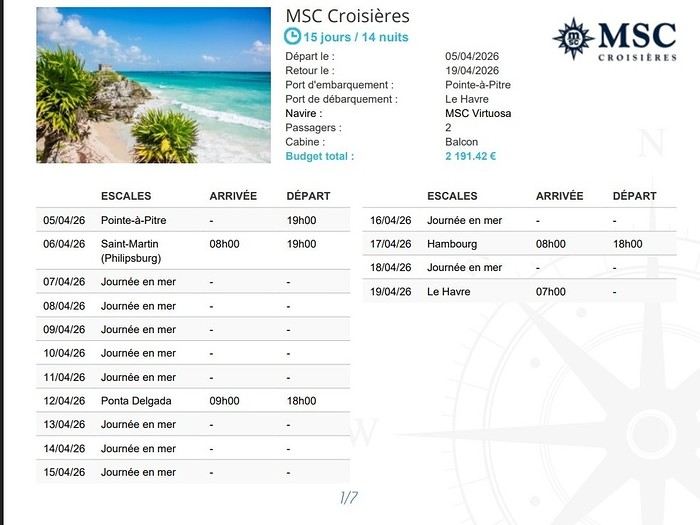
But as I mentioned, it wasn’t about the itinerary. It was really about taking a break and unwinding. Honestly, I came back thrilled.
Departure and boarding details to come
As promised, here’s my review of the cruise I took from the 5th to the 19th on the MSC Virtuosa.
As you know, I had initially booked a cruise with Mein Schiff departing from Dubai (from Dubai to Cape Town). It was a 22-day cruise. Due to the issues in the Persian Gulf, my cruise was canceled by Mein Schiff.
So, we started looking for a Plan B because we really wanted to go. Especially my wife, who had just had a minor procedure and needed some rest. Since she had already taken time off, she was determined to travel. However, we were looking for an affordable Plan B since we weren’t sure when Mein Schiff or the airline would reimburse us.
While browsing online, I found a 15-day cruise departing from Pointe-à-Pitre (including flights, transfers, the cruise, and drinks) for a price of 1,200 € in a Fantastica balcony cabin. We thought, *Why not?*
I should mention that I’m not usually a big fan of MSC. My last experience with them was post-Covid (I took two cruises, one in 2021 and another in 2022), and it was honestly a disaster. We didn’t want to repeat that, but after talking to Catherine, who told me she was very happy with a short Christmas cruise, we decided to give it a try.
I have to say, I was left speechless. Honestly, the cruise was absolutely perfect. There’s nothing to complain about (or just a few minor details). In terms of service and food, I felt like I was on a premium cruise line. I’d even say MSC has nothing to envy from some of those companies. While premium lines like Holland, Celebrity, and Royal are cutting back on services, I think MSC has made huge improvements. Seriously, I wasn’t expecting this at all. You’ll see what I mean as we chat more.
I won’t do a full review like I usually do because there weren’t many stops: 1. We boarded in Pointe-à-Pitre 2. We stopped in Saint-Martin 3. Then it was a direct crossing to the Azores...
This cruise was really about relaxing, even if it’s not the kind of trip we usually take.
First off, I’m not a big fan of "flight and cruise" packages. I asked if we could leave two days early, but they said it wasn’t possible. We had to take the flight, then the bus, and board the ship directly.
It’s not really my thing, but given the price we paid and since we really wanted to relax, we thought, *Why not?*
Here’s the itinerary:
Boarding in Pointe-à-Pitre Saint-Martin Five days at sea The Azores Four days at sea Hamburg One day at sea Le Havre
But as I mentioned, it wasn’t about the itinerary. It was really about taking a break and unwinding. Honestly, I came back thrilled.
Departure and boarding details to come
Costa Rica: The dry season isn't what it used to be!
Introduction:
For years, I’ve heard about Costa Rica, which seems like a country "made for me"—nature, not cities.
I almost went in 2019, but a family issue made me cancel.
Initially, I wanted to spend at least three weeks there, planning to go in our summer despite it being the rainy season. Then I realized what I wanted to do could fit into two weeks, so I ended up going in February.
Plus, January’s weather was so awful that some sunshine should do me good.
I found a flight at a decent price, but with two downsides.
The first is that it leaves from Paris CDG, and the second is that it’s with Air France—a airline I’d sworn off after my misadventures with them back in 2008. We’ll see how it goes!
5 weeks in the American West with family in summer 2026
Hi everyone!
After years of hoping, waiting, planning, then changing, saving, and searching for the best possible route... we're FINALLY off this summer for a 5-week road trip in the West.
I had planned a trip to Colorado in 2021 but canceled due to COVID, so with time passing and my eldest’s high school graduation approaching fast, I figured it was now or never!
Anyway, the itinerary has been modified and extended to please everyone (I’m no longer the only one making decisions!!)
Here’s our final route: Day 1 - 7/12/2026 - Brussels / Los Angeles Day 2 - 7/13/2026 - Los Angeles Day 3 - 7/14/2026 - Los Angeles Day 4 - 7/15/2026 - Los Angeles Day 5 - 7/16/2026 - Los Angeles Day 6 - 7/17/2026 - Los Angeles / Kingman Day 7 - 7/18/2026 - Kingman / Grand Canyon Day 8 - 7/19/2026 - Grand Canyon / Page Day 9 - 7/20/2026 - Page Day 10 - 7/21/2026 - Page / Monument Valley Day 11 - 7/22/2026 - Monument Valley / Durango Day 12 - 7/23/2026 - Durango Day 13 - 7/24/2026 - Durango Day 14 - 7/25/2026 - Durango Day 15 - 7/26/2026 - Durango / Glenwood Springs Day 16 - 7/27/2026 - Glenwood Springs Day 17 - 7/28/2026 - Glenwood Springs / Moab Day 18 - 7/29/2026 - Moab Day 19 - 7/30/2026 - Moab Day 20 - 7/31/2026 - Moab Day 21 - 8/1/2026 - Moab Day 22 - 8/2/2026 - Moab / Vernal Day 23 - 8/3/2026 - Vernal / Grand Teton Day 24 - 8/4/2026 - Grand Teton Day 25 - 8/5/2026 - Grand Teton / Cody Day 26 - 8/6/2026 - Cody / Yellowstone Day 27 - 8/7/2026 - Yellowstone Day 28 - 8/8/2026 - Yellowstone Day 29 - 8/9/2026 - Yellowstone Day 30 - 8/10/2026 - Yellowstone / Salt Lake City Day 31 - 8/11/2026 - Salt Lake City / Bryce Canyon Day 32 - 8/12/2026 - Bryce Canyon / Zion Day 33 - 8/13/2026 - Zion Day 34 - 8/14/2026 - Zion Day 35 - 8/15/2026 - Zion / Las Vegas Day 36 - 8/16/2026 - Las Vegas Day 37 - 8/17/2026 - Las Vegas / Los Angeles Day 38 - 8/18/2026 - Los Angeles Day 39 - 8/19/2026 - Los Angeles / Brussels Day 40 - 8/20/2026 - Brussels / Home
We’ll be alternating between house swaps, motels, and campgrounds. I’ve booked all the accommodations (except the campground at Bryce since sunset bookings open only 14 days in advance) and the first activities, as well as the most touristy ones.
I’m currently putting together my day-by-day roadbook and having some trouble planning certain days, like in LA or Las Vegas. Choosing hikes isn’t easy either—it’s tough to decide!
We’re really excited but could definitely use your help with choices and optimizations!!
I had planned a trip to Colorado in 2021 but canceled due to COVID, so with time passing and my eldest’s high school graduation approaching fast, I figured it was now or never!
Anyway, the itinerary has been modified and extended to please everyone (I’m no longer the only one making decisions!!)
Here’s our final route: Day 1 - 7/12/2026 - Brussels / Los Angeles Day 2 - 7/13/2026 - Los Angeles Day 3 - 7/14/2026 - Los Angeles Day 4 - 7/15/2026 - Los Angeles Day 5 - 7/16/2026 - Los Angeles Day 6 - 7/17/2026 - Los Angeles / Kingman Day 7 - 7/18/2026 - Kingman / Grand Canyon Day 8 - 7/19/2026 - Grand Canyon / Page Day 9 - 7/20/2026 - Page Day 10 - 7/21/2026 - Page / Monument Valley Day 11 - 7/22/2026 - Monument Valley / Durango Day 12 - 7/23/2026 - Durango Day 13 - 7/24/2026 - Durango Day 14 - 7/25/2026 - Durango Day 15 - 7/26/2026 - Durango / Glenwood Springs Day 16 - 7/27/2026 - Glenwood Springs Day 17 - 7/28/2026 - Glenwood Springs / Moab Day 18 - 7/29/2026 - Moab Day 19 - 7/30/2026 - Moab Day 20 - 7/31/2026 - Moab Day 21 - 8/1/2026 - Moab Day 22 - 8/2/2026 - Moab / Vernal Day 23 - 8/3/2026 - Vernal / Grand Teton Day 24 - 8/4/2026 - Grand Teton Day 25 - 8/5/2026 - Grand Teton / Cody Day 26 - 8/6/2026 - Cody / Yellowstone Day 27 - 8/7/2026 - Yellowstone Day 28 - 8/8/2026 - Yellowstone Day 29 - 8/9/2026 - Yellowstone Day 30 - 8/10/2026 - Yellowstone / Salt Lake City Day 31 - 8/11/2026 - Salt Lake City / Bryce Canyon Day 32 - 8/12/2026 - Bryce Canyon / Zion Day 33 - 8/13/2026 - Zion Day 34 - 8/14/2026 - Zion Day 35 - 8/15/2026 - Zion / Las Vegas Day 36 - 8/16/2026 - Las Vegas Day 37 - 8/17/2026 - Las Vegas / Los Angeles Day 38 - 8/18/2026 - Los Angeles Day 39 - 8/19/2026 - Los Angeles / Brussels Day 40 - 8/20/2026 - Brussels / Home
We’ll be alternating between house swaps, motels, and campgrounds. I’ve booked all the accommodations (except the campground at Bryce since sunset bookings open only 14 days in advance) and the first activities, as well as the most touristy ones.
I’m currently putting together my day-by-day roadbook and having some trouble planning certain days, like in LA or Las Vegas. Choosing hikes isn’t easy either—it’s tough to decide!
We’re really excited but could definitely use your help with choices and optimizations!!
The Foam of Days
Now that the curtain has fallen on the past year, it’s time to see what’s happening around here.
It seems pretty quiet, but I’ll read more in detail later.
First, I need to tell you all an anecdote.
My eldest little girl, in her third year of law school, was really scared she wouldn’t pass the year. I told her: “Trust yourself, you’ve worked so hard, and worst case, if you fail, you’ll just redo the year.” “But I don’t think I’ll make it—they changed the rules, and if I mess up even one unit, I have to start all over.” I knew her grades weren’t exactly stellar, and with what I was about to say, I wasn’t taking much of a risk. “Here’s the deal, sweetheart: if you pass, I promise I’ll take you to India, just the two of us.” I have to admit, India is a country I’ve talked about so much to all my grandchildren that in their minds, it’s become a magical, mythical place (hmm).
July had barely begun when my phone rang, her name flashing on the screen. “Mamido, I did it!” My promise came rushing back—oh no, oh no, oh no! “Congratulations, sweetheart!” A little shyly, she said: “Is the India trip still on?”
And me, replying: “Of course it is!”
And that’s that—a promise is a promise, or you risk losing that precious trust that keeps hearts warm and at peace.
We’re leaving in February. Only 8 days—yikes, the carbon footprint! But we can’t miss her tutorials, or she’ll be kicked out. Personally, that works just fine for me.
Going to India has become a challenge for me. It’s far, it’s exhausting, I sweat, I hate mosquitoes, the spices bother my mouth when I used to love them. There’s noise all the time—at night, the dogs bark nonstop, and we almost get run over. I’ll get lost in the streets because my sense of direction has vanished. I don’t like rice anymore. All that chaos and those cultural differences that once enchanted me now just overwhelm me. But I promised.
The upside—and it’s a big one—Raman, the same driver I’ve had forever, will be at the airport with a sign with our names. We’ll stop at the same little shop for chai (or tea, plain and simple) with that aroma that intoxicates me, halfway through the trip.
It’ll be a tiny trip—staying with friends, I’ll show her a few places I love: Chidambaram, Mamallapuram, and the clinic where I worked. Then we’ll head back. My little girl will go home to her parents.
As for me, I’ll leave right away for our Scottish island with Homme for our chilly winter.
How can you love a country so much you want to live there, then suddenly reject it, no longer able to appreciate what once made it special? That’s the mystery of love, I guess.
First, I need to tell you all an anecdote.
My eldest little girl, in her third year of law school, was really scared she wouldn’t pass the year. I told her: “Trust yourself, you’ve worked so hard, and worst case, if you fail, you’ll just redo the year.” “But I don’t think I’ll make it—they changed the rules, and if I mess up even one unit, I have to start all over.” I knew her grades weren’t exactly stellar, and with what I was about to say, I wasn’t taking much of a risk. “Here’s the deal, sweetheart: if you pass, I promise I’ll take you to India, just the two of us.” I have to admit, India is a country I’ve talked about so much to all my grandchildren that in their minds, it’s become a magical, mythical place (hmm).
July had barely begun when my phone rang, her name flashing on the screen. “Mamido, I did it!” My promise came rushing back—oh no, oh no, oh no! “Congratulations, sweetheart!” A little shyly, she said: “Is the India trip still on?”
And me, replying: “Of course it is!”
And that’s that—a promise is a promise, or you risk losing that precious trust that keeps hearts warm and at peace.
We’re leaving in February. Only 8 days—yikes, the carbon footprint! But we can’t miss her tutorials, or she’ll be kicked out. Personally, that works just fine for me.
Going to India has become a challenge for me. It’s far, it’s exhausting, I sweat, I hate mosquitoes, the spices bother my mouth when I used to love them. There’s noise all the time—at night, the dogs bark nonstop, and we almost get run over. I’ll get lost in the streets because my sense of direction has vanished. I don’t like rice anymore. All that chaos and those cultural differences that once enchanted me now just overwhelm me. But I promised.
The upside—and it’s a big one—Raman, the same driver I’ve had forever, will be at the airport with a sign with our names. We’ll stop at the same little shop for chai (or tea, plain and simple) with that aroma that intoxicates me, halfway through the trip.
It’ll be a tiny trip—staying with friends, I’ll show her a few places I love: Chidambaram, Mamallapuram, and the clinic where I worked. Then we’ll head back. My little girl will go home to her parents.
As for me, I’ll leave right away for our Scottish island with Homme for our chilly winter.
How can you love a country so much you want to live there, then suddenly reject it, no longer able to appreciate what once made it special? That’s the mystery of love, I guess.
My first trip to Iceland, over 50 years ago.
My first trip to Iceland, in 1974.
Yes, you might be surprised: my first trip to Iceland dates back to July 1974. It’s been a little over 50 years since I first set foot on Icelandic soil. I was 23 years old. At the time, I was a geography student. I had just earned my bachelor’s degree and was finishing my master’s (what we’d now call a "master’s 2") in physical geography, with two specialties: glaciology and volcanology. In both fields, professors showed us slides of Iceland—glaciers and volcanoes—and in tutorials, we worked on maps and documents related to the physical geography of Iceland. So there you have it: ice and fire, in Icelandic « ís og eldur », I learned that year that it was Iceland’s national motto, and that’s what drew me there for my first big trip.
Iceland in 1974 was very different from today. It wasn’t a common destination. There were practically no tourists or tourist infrastructure. Some sites now famous and overcrowded were only accessible after hours of hiking on rough, unmarked trails. GPS didn’t exist, but I had managed to get local 1:100,000 maps that were pretty well done. I took my time to circle the entire island, camping in the wild. Most of my meager budget went toward the flight ticket and renting a Volkswagen "Beetle."
There were no paved roads in the country except in central Reykjavík and the main street of Akureyri. What’s now called Route 1 was everywhere dirt and gravel, pretty bumpy in places. According to my maps, this road didn’t allow for a full loop around Iceland: a section of about a hundred kilometers was missing on the south coast. But when I arrived in that area, I learned at a gas station that the last missing section had just been completed, finally allowing a full loop without backtracking. It was the section crossing the vast Skeiðarársandur, southwest of Vatnajökull. The new road was just a bulldozer track through this black ash desert. We crossed the multiple channels of the sandur on long single-lane wooden bridges. On these long pilings, the road was made of roughly nailed thick planks that made an awful racket when the car drove over them.
A nasty surprise: the cost of living. The difference with France seemed huge—everything was two to three times more expensive than back home. Prices were way beyond my tiny budget, and I wondered how I’d manage to get by.
The Icelanders back then were very different from today. From the start, I felt like a real outsider, ostracized, even outright rejected. Several times, when I asked for permission to pitch my small tent near a farm, the door would slam shut as soon as I asked (in English). Without a word… *Bam!*
So I struggled to feed myself, lacking money. I mostly bought loaves of sliced bread and corn flakes (unknown in France at the time), which I ate with cold, sugary milk. It was the cheapest and most filling thing I could find.
In Reykjavík, my only luxury was daring to enter a snack bar. There, I’d treat myself to a coffee or tea, having quickly learned that after paying for a cup once, you could go back to the counter and have it refilled as much as you wanted. I dreaded being asked if I wanted something to eat because I couldn’t afford it. Luckily, no one asked. So, alone in my corner, I’d pull out my loaf of sliced bread from my backpack and make sandwiches with the contents of the two plastic bottles on every table—one red, one yellow: ketchup and sweet mustard. I avoided the sideways glances from other customers. I’d eat my sandwiches and leave, both full and warmed up.
One time, near Selfoss, I saw a truck stop by the road and pick up two large aluminum cans left at the end of a farm track. A little further down the road, two more similar cans. I realized these cans were there to be collected by… well, I didn’t know who. No one in sight for miles. So, I’ll admit it: I stopped and opened one of those large cans, which contained a dairy product—a kind of very dense, compact white cheese (I later learned it was skyr). I scooped a nice layer from the top, smoothed the surface with my spoon, and carefully closed the can again. Yes, I know it wasn’t right, but that was over fifty years ago, and I can admit it now since the statute of limitations has surely passed, right? Another time, I boiled a piece of dried fish, hard as wood, for a long time on my camping stove—fish I’d taken from huge outdoor drying racks by the side of the road. On the road heading north from Reykjavík, the Akranes underwater tunnel didn’t exist yet. To get to Borgarnes and Snæfellsnes, you had to go around Hvalfjörður. Following the shore of this long fjord, I stumbled upon a whaling station in full operation. Intrigued by the plumes of steam and the sounds of machinery from the road, I stopped, and surprisingly, no one stopped me from entering the vast platform where workers were butchering a large whale. I’ll never forget the acrid smell of those huge piles of meat and bones, fat and guts, the screams of saws and winches, the steam from the boilers… A monstrous, hallucinatory sight that would shape a major interest for the rest of my life: whales.
At the end of my journey, I spent three days in the Westman Islands. The famous eruption of the Eldfell volcano had happened just months earlier, in 1973, and was barely over. Visiting Heimaey was one of the goals of my trip to Iceland, given my volcanology studies. Part of the fishing port was filled in by lava flows, and the entrance channel was reduced to just a few meters wide. Most of the village was covered by a layer of black, hot ash eight to ten meters thick. I walked on the roofs of houses—every now and then, a chimney or skylight would stick out. In the rain, this hot ash released intense steam; you couldn’t see twenty meters ahead. It felt like being in a giant outdoor sauna. The entire population had been evacuated during the eruption, but some residents were starting to return. Bulldozers and excavators were gradually clearing this gigantic mass of ash, street by street, layer by layer, avoiding demolishing the buried houses. A constant stream of trucks dumped these millions of tons of ash into the sea from a cliff. To finish clearing the houses, it was done with shovels and wheelbarrows, and this task was left to the homeowners. One day, I had the chance to lend a hand (or rather, a shovel) to a couple finishing clearing their house. They offered to let me pitch my tent near their place, on a thick layer of warm ash (I’d never experienced such comfort through my sleeping mat), and I’ll never forget that they gave me a big bowl of delicious soup they’d just made. The best meal I had during that trip. The next day, climbing the volcano, which was still smoking and spewing furiously, I nearly suffocated from sulfur dioxide and almost melted the soles of my shoes. So it was during this initiatory trip, 50 years ago, that my addiction to Iceland was born. The following year in Paris, by sheer chance—and perhaps helped by the magic of my amazing Kodachrome slides—I met a young woman who would become my wife. Very quickly, she became as hooked as I was on "the island of the world’s creation" (as I called it back then), and later, it was often her who’d say, "So… how about going back to Iceland this year?" We went back many times, in every season, summer and winter, and in every region of the country. And every time, when the plane starts its descent toward Keflavík Airport, we look at each other like kids invited to a birthday party, discovering the cake buffet… "Here we are… we’re back!"
Our travel conditions changed a lot afterward. With a better budget but still traveling independently, renting well-equipped 4x4s that let us go almost anywhere, at our own pace, including the highlands of the country’s interior. But always taking our time, dedicating each trip to fully exploring one region rather than rushing through kilometers. And leaving time for beautiful hikes or simply doing nothing—sitting at a viewpoint and just watching, observing the wild nature, in contemplative mode… Always staying with locals in the countryside, preferably on real farms with animals, thanks to an association of farmers offering accommodations. We speak fluent English and have learned a few common Icelandic phrases and expressions over time. With a bit of experience, we developed our little techniques for starting interesting conversations with Icelanders… who, thankfully, are no longer as distant as they were in 1974! We even made friends there.
We particularly loved the rugged, wild Iceland—not necessarily the desolate highlands of the interior, but rather the isolated regions where a few very old families still cling to their land and roots. With a soft spot for the Snæfellsnes Peninsula and especially the Westfjords, the "Vestfirðir," as the Icelanders call them. But we also love the Northeast, and even the far Northeast, so remote and where almost no one goes. Over time, we’ve done a lot of reading. We’ve learned a great deal about Iceland—its painful history, its tormented geography, its economy, its incredible medieval literature (the Sagas), and some quirks of its culture. And we greatly appreciate its contemporary authors, whose books fill several shelves in our library.
In 2008, on a return trip to Iceland, we went to the Westman Islands, to Heimaey. I hadn’t been back since my first trip in 1974, right after the Eldfell eruption. It was a pilgrimage for me, so many years later! An emotional moment seeing the huge frozen lava flow again. On the trails now set up to explore this vast chaos, people have put up signs indicating the names of the streets buried under the lava and the nature of the crushed buildings fifteen meters below. Plaques mark the locations of public buildings—here was the school, down there was the hospital… The part of the town that was under ash has been cleared, but not entirely—two streets were left partially buried, probably to show tourists. The volcano is still hot at the top. We climbed it, but this time I didn’t melt my soles.
We often talk about Iceland. We still call it "the island of the world’s creation" and tell our traveler friends how much this country fascinated and enchanted us. Those who’ve never been find it a bit odd, but everyone who’s been there understands.
You may have noticed I’m talking about it in the past tense… Indeed, I’ll admit that for several years now, we haven’t been back to Iceland, and I don’t think we’ll return. What we see on social media and in the news puts us off a bit. Mass tourism has arrived, and many developments have been made—not always for the best. Now, with two and a half million visitors a year, Iceland welcomes nearly six times its population. Tourism has become a key source of income for Icelanders. Good for them, maybe, but we don’t like it at all. We’re a bit wild, perhaps. And besides… the world is vast… We loved Iceland passionately, but we’ve always been inveterate travelers in general. So over the past fifty years, we’ve certainly explored all of Iceland’s regions, but also in the North Atlantic—the beautiful Norway, the stunning Lofoten Islands, the Shetland archipelago, the rugged and grand Faroe Islands, and then further north in the Arctic—the icy Greenland, Svalbard at the edge of the world, and even the Sjuøyane, the last islands before the North Pole, with small groups of enthusiasts and scientists on expedition ships. And many other regions of the world, but always with a taste for slightly offbeat places, both in terms of landscapes and nature and ways of life. Central Asia, the Azores, Peru, Bolivia, the Andes, Chile, Argentina, the vast Patagonia, Tierra del Fuego… and other little secret gems we won’t reveal. Not even on Voyage Forum.
But everywhere—yes, I mean everywhere—wherever you are, wherever you go, there’s always a moment when you think of Iceland…
Chris 51 - November 2025.
Yes, you might be surprised: my first trip to Iceland dates back to July 1974. It’s been a little over 50 years since I first set foot on Icelandic soil. I was 23 years old. At the time, I was a geography student. I had just earned my bachelor’s degree and was finishing my master’s (what we’d now call a "master’s 2") in physical geography, with two specialties: glaciology and volcanology. In both fields, professors showed us slides of Iceland—glaciers and volcanoes—and in tutorials, we worked on maps and documents related to the physical geography of Iceland. So there you have it: ice and fire, in Icelandic « ís og eldur », I learned that year that it was Iceland’s national motto, and that’s what drew me there for my first big trip.
Iceland in 1974 was very different from today. It wasn’t a common destination. There were practically no tourists or tourist infrastructure. Some sites now famous and overcrowded were only accessible after hours of hiking on rough, unmarked trails. GPS didn’t exist, but I had managed to get local 1:100,000 maps that were pretty well done. I took my time to circle the entire island, camping in the wild. Most of my meager budget went toward the flight ticket and renting a Volkswagen "Beetle."
There were no paved roads in the country except in central Reykjavík and the main street of Akureyri. What’s now called Route 1 was everywhere dirt and gravel, pretty bumpy in places. According to my maps, this road didn’t allow for a full loop around Iceland: a section of about a hundred kilometers was missing on the south coast. But when I arrived in that area, I learned at a gas station that the last missing section had just been completed, finally allowing a full loop without backtracking. It was the section crossing the vast Skeiðarársandur, southwest of Vatnajökull. The new road was just a bulldozer track through this black ash desert. We crossed the multiple channels of the sandur on long single-lane wooden bridges. On these long pilings, the road was made of roughly nailed thick planks that made an awful racket when the car drove over them.
A nasty surprise: the cost of living. The difference with France seemed huge—everything was two to three times more expensive than back home. Prices were way beyond my tiny budget, and I wondered how I’d manage to get by.
The Icelanders back then were very different from today. From the start, I felt like a real outsider, ostracized, even outright rejected. Several times, when I asked for permission to pitch my small tent near a farm, the door would slam shut as soon as I asked (in English). Without a word… *Bam!*
So I struggled to feed myself, lacking money. I mostly bought loaves of sliced bread and corn flakes (unknown in France at the time), which I ate with cold, sugary milk. It was the cheapest and most filling thing I could find.
In Reykjavík, my only luxury was daring to enter a snack bar. There, I’d treat myself to a coffee or tea, having quickly learned that after paying for a cup once, you could go back to the counter and have it refilled as much as you wanted. I dreaded being asked if I wanted something to eat because I couldn’t afford it. Luckily, no one asked. So, alone in my corner, I’d pull out my loaf of sliced bread from my backpack and make sandwiches with the contents of the two plastic bottles on every table—one red, one yellow: ketchup and sweet mustard. I avoided the sideways glances from other customers. I’d eat my sandwiches and leave, both full and warmed up.
One time, near Selfoss, I saw a truck stop by the road and pick up two large aluminum cans left at the end of a farm track. A little further down the road, two more similar cans. I realized these cans were there to be collected by… well, I didn’t know who. No one in sight for miles. So, I’ll admit it: I stopped and opened one of those large cans, which contained a dairy product—a kind of very dense, compact white cheese (I later learned it was skyr). I scooped a nice layer from the top, smoothed the surface with my spoon, and carefully closed the can again. Yes, I know it wasn’t right, but that was over fifty years ago, and I can admit it now since the statute of limitations has surely passed, right? Another time, I boiled a piece of dried fish, hard as wood, for a long time on my camping stove—fish I’d taken from huge outdoor drying racks by the side of the road. On the road heading north from Reykjavík, the Akranes underwater tunnel didn’t exist yet. To get to Borgarnes and Snæfellsnes, you had to go around Hvalfjörður. Following the shore of this long fjord, I stumbled upon a whaling station in full operation. Intrigued by the plumes of steam and the sounds of machinery from the road, I stopped, and surprisingly, no one stopped me from entering the vast platform where workers were butchering a large whale. I’ll never forget the acrid smell of those huge piles of meat and bones, fat and guts, the screams of saws and winches, the steam from the boilers… A monstrous, hallucinatory sight that would shape a major interest for the rest of my life: whales.
At the end of my journey, I spent three days in the Westman Islands. The famous eruption of the Eldfell volcano had happened just months earlier, in 1973, and was barely over. Visiting Heimaey was one of the goals of my trip to Iceland, given my volcanology studies. Part of the fishing port was filled in by lava flows, and the entrance channel was reduced to just a few meters wide. Most of the village was covered by a layer of black, hot ash eight to ten meters thick. I walked on the roofs of houses—every now and then, a chimney or skylight would stick out. In the rain, this hot ash released intense steam; you couldn’t see twenty meters ahead. It felt like being in a giant outdoor sauna. The entire population had been evacuated during the eruption, but some residents were starting to return. Bulldozers and excavators were gradually clearing this gigantic mass of ash, street by street, layer by layer, avoiding demolishing the buried houses. A constant stream of trucks dumped these millions of tons of ash into the sea from a cliff. To finish clearing the houses, it was done with shovels and wheelbarrows, and this task was left to the homeowners. One day, I had the chance to lend a hand (or rather, a shovel) to a couple finishing clearing their house. They offered to let me pitch my tent near their place, on a thick layer of warm ash (I’d never experienced such comfort through my sleeping mat), and I’ll never forget that they gave me a big bowl of delicious soup they’d just made. The best meal I had during that trip. The next day, climbing the volcano, which was still smoking and spewing furiously, I nearly suffocated from sulfur dioxide and almost melted the soles of my shoes. So it was during this initiatory trip, 50 years ago, that my addiction to Iceland was born. The following year in Paris, by sheer chance—and perhaps helped by the magic of my amazing Kodachrome slides—I met a young woman who would become my wife. Very quickly, she became as hooked as I was on "the island of the world’s creation" (as I called it back then), and later, it was often her who’d say, "So… how about going back to Iceland this year?" We went back many times, in every season, summer and winter, and in every region of the country. And every time, when the plane starts its descent toward Keflavík Airport, we look at each other like kids invited to a birthday party, discovering the cake buffet… "Here we are… we’re back!"
Our travel conditions changed a lot afterward. With a better budget but still traveling independently, renting well-equipped 4x4s that let us go almost anywhere, at our own pace, including the highlands of the country’s interior. But always taking our time, dedicating each trip to fully exploring one region rather than rushing through kilometers. And leaving time for beautiful hikes or simply doing nothing—sitting at a viewpoint and just watching, observing the wild nature, in contemplative mode… Always staying with locals in the countryside, preferably on real farms with animals, thanks to an association of farmers offering accommodations. We speak fluent English and have learned a few common Icelandic phrases and expressions over time. With a bit of experience, we developed our little techniques for starting interesting conversations with Icelanders… who, thankfully, are no longer as distant as they were in 1974! We even made friends there.
We particularly loved the rugged, wild Iceland—not necessarily the desolate highlands of the interior, but rather the isolated regions where a few very old families still cling to their land and roots. With a soft spot for the Snæfellsnes Peninsula and especially the Westfjords, the "Vestfirðir," as the Icelanders call them. But we also love the Northeast, and even the far Northeast, so remote and where almost no one goes. Over time, we’ve done a lot of reading. We’ve learned a great deal about Iceland—its painful history, its tormented geography, its economy, its incredible medieval literature (the Sagas), and some quirks of its culture. And we greatly appreciate its contemporary authors, whose books fill several shelves in our library.
In 2008, on a return trip to Iceland, we went to the Westman Islands, to Heimaey. I hadn’t been back since my first trip in 1974, right after the Eldfell eruption. It was a pilgrimage for me, so many years later! An emotional moment seeing the huge frozen lava flow again. On the trails now set up to explore this vast chaos, people have put up signs indicating the names of the streets buried under the lava and the nature of the crushed buildings fifteen meters below. Plaques mark the locations of public buildings—here was the school, down there was the hospital… The part of the town that was under ash has been cleared, but not entirely—two streets were left partially buried, probably to show tourists. The volcano is still hot at the top. We climbed it, but this time I didn’t melt my soles.
We often talk about Iceland. We still call it "the island of the world’s creation" and tell our traveler friends how much this country fascinated and enchanted us. Those who’ve never been find it a bit odd, but everyone who’s been there understands.
You may have noticed I’m talking about it in the past tense… Indeed, I’ll admit that for several years now, we haven’t been back to Iceland, and I don’t think we’ll return. What we see on social media and in the news puts us off a bit. Mass tourism has arrived, and many developments have been made—not always for the best. Now, with two and a half million visitors a year, Iceland welcomes nearly six times its population. Tourism has become a key source of income for Icelanders. Good for them, maybe, but we don’t like it at all. We’re a bit wild, perhaps. And besides… the world is vast… We loved Iceland passionately, but we’ve always been inveterate travelers in general. So over the past fifty years, we’ve certainly explored all of Iceland’s regions, but also in the North Atlantic—the beautiful Norway, the stunning Lofoten Islands, the Shetland archipelago, the rugged and grand Faroe Islands, and then further north in the Arctic—the icy Greenland, Svalbard at the edge of the world, and even the Sjuøyane, the last islands before the North Pole, with small groups of enthusiasts and scientists on expedition ships. And many other regions of the world, but always with a taste for slightly offbeat places, both in terms of landscapes and nature and ways of life. Central Asia, the Azores, Peru, Bolivia, the Andes, Chile, Argentina, the vast Patagonia, Tierra del Fuego… and other little secret gems we won’t reveal. Not even on Voyage Forum.
But everywhere—yes, I mean everywhere—wherever you are, wherever you go, there’s always a moment when you think of Iceland…
Chris 51 - November 2025.
Cambodia and Indonesia in summer: ideal itinerary with kids?
Hi everyone,
After letting our backpacks gather dust for several years, we’ve decided to set off on another adventure—this time as a family, with our 10- and 12-year-old kids! We’re planning a trip from mid-June to the end of July, with two stops: Cambodia (2 weeks) and Indonesia (4 weeks). But before diving into the details, we’ve got quite a few questions and doubts.
About Cambodia: We know this period is the rainy season. Is it really a good idea to go then? And if so, is it better to start with Cambodia and then move on to Indonesia, or does the order not matter from a climate perspective? Here are the activities and sites we’ve shortlisted: · The Mekong and Irrawaddy dolphins: do we actually have a chance of seeing them? · The Mondulkiri Project (elephant sanctuary): is this an ethical project? We want to avoid any form of animal exploitation. · The temples of Angkor: are 2 or 3 days enough to fully enjoy them? · Floating villages: where should we go for an authentic experience? Is it possible to spend the night there? · Hikes with waterfalls, lakes, etc.: are there any must-do treks? · And most importantly, what activities or sites would appeal to kids?
For Indonesia: We were there 15 years ago and loved our itinerary: Yogyakarta / Borobudur → Bromo → Kawah Ijen → Bali → Gili Trawangan. This time, we’re torn: · Retracing part of that route to share it with our kids (even if revisiting the same places isn’t super appealing), · Or exploring new regions. What’s almost certain is that we’d like to spend about two weeks in Raja Ampat. For the other two weeks, we’re undecided. We’re looking for kid-friendly ideas for places and activities, while avoiding too many connections for budget and environmental reasons. Since we’ll already see temples in Cambodia, we’d like to mix things up.
And finally… On our last trip to the region, we traveled without kids and went super free-spirited: only the round-trip tickets were booked, and we improvised the rest day by day without any major issues finding accommodation, food, or accessing the activities we’d spotted. Do you think this style of travel is still doable with two kids? Or has it become too risky or stressful? Are there regions where the "backpacker" approach is still possible, and others where it’s better to book in advance? And for certain activities or sites, is it recommended to hire guides?
Thanks in advance for your tips and experiences!
After letting our backpacks gather dust for several years, we’ve decided to set off on another adventure—this time as a family, with our 10- and 12-year-old kids! We’re planning a trip from mid-June to the end of July, with two stops: Cambodia (2 weeks) and Indonesia (4 weeks). But before diving into the details, we’ve got quite a few questions and doubts.
About Cambodia: We know this period is the rainy season. Is it really a good idea to go then? And if so, is it better to start with Cambodia and then move on to Indonesia, or does the order not matter from a climate perspective? Here are the activities and sites we’ve shortlisted: · The Mekong and Irrawaddy dolphins: do we actually have a chance of seeing them? · The Mondulkiri Project (elephant sanctuary): is this an ethical project? We want to avoid any form of animal exploitation. · The temples of Angkor: are 2 or 3 days enough to fully enjoy them? · Floating villages: where should we go for an authentic experience? Is it possible to spend the night there? · Hikes with waterfalls, lakes, etc.: are there any must-do treks? · And most importantly, what activities or sites would appeal to kids?
For Indonesia: We were there 15 years ago and loved our itinerary: Yogyakarta / Borobudur → Bromo → Kawah Ijen → Bali → Gili Trawangan. This time, we’re torn: · Retracing part of that route to share it with our kids (even if revisiting the same places isn’t super appealing), · Or exploring new regions. What’s almost certain is that we’d like to spend about two weeks in Raja Ampat. For the other two weeks, we’re undecided. We’re looking for kid-friendly ideas for places and activities, while avoiding too many connections for budget and environmental reasons. Since we’ll already see temples in Cambodia, we’d like to mix things up.
And finally… On our last trip to the region, we traveled without kids and went super free-spirited: only the round-trip tickets were booked, and we improvised the rest day by day without any major issues finding accommodation, food, or accessing the activities we’d spotted. Do you think this style of travel is still doable with two kids? Or has it become too risky or stressful? Are there regions where the "backpacker" approach is still possible, and others where it’s better to book in advance? And for certain activities or sites, is it recommended to hire guides?
Thanks in advance for your tips and experiences!
Yet Another Travel Journal in this (Too) Familiar Rajasthan, But with Family and Kids
Prologue
This journal recounts a trip to Rajasthan that’s already over a year old and that I’ve only now found the chance to write about. The summer of 2024 marked my return to India—my tenth trip—after six long years away since my last solo wanderings in Tamil Nadu in 2018 (the journal of which is published on this site). That absence was partly (but not only) due to the long COVID and post-COVID period, which saw a complete halt and then a major slowdown in global tourism. To top it off, Voyage Forum announced its closure in an end-of-the-world atmosphere. A sad time for our favorite social activity…
A few weeks after returning from Rajasthan, I tried to motivate myself to start writing a journal to publish on a forum claiming to be VF’s successor, which I’d eventually signed up for out of desperation. But I kept hesitating and putting the project off because, for one, I no longer have the time I used to. For another, the vibe wasn’t really taking off on that forum—it was overrun with ads and not very active, contrary to what its host’s name suggested. Despite its good intentions and commendable role as a stopgap, it also turned out to be very impractical to use, especially when you don’t have much time like me. I’ll admit I’d occasionally check back on VF to see if anything was happening. But all the discussions remained frozen in time, stuck in that fateful year, 2020. Then, rumors swirled online about shady reasons behind its closure, leaving little room for hope.
And then, one fine morning, I got a message at work from Marien informing me that VF had reopened. What a huge surprise! Even though the forum’s “end” had played out in a somewhat apocalyptic atmosphere, the memories of passionate and heated discussions, the frank debates, and the useful exchanges that made this site a traveler’s goldmine and a unique hub of conviviality all came rushing back to me like a breath of fresh air. I finally saw a sign and tried to motivate myself to find the time to publish the journal of this tenth trip to India and fifth to Rajasthan. But in the end, I got bogged down in professional and family obligations and never managed to find the time to get started. That’s now fixed, though, because I had two reasons for wanting to do it: I find that looking back on a trip to tell others about it is a highly beneficial introspective exercise. Also, I thought this journal could be useful to other travelers on a few points.
Because, “do we really need yet another journal about Rajasthan?” you might rightly ask! Especially in a time when so many journals about the “Land of Kings” have been published since VF’s return, not to mention the countless stories you can already find online about this region, one of India’s most touristy. And I’d add, why go back to Rajasthan for a fifth time, where I’ve already dragged my feet more than enough—through its forts, deserts, temples, cities, villages, bumpy roads, train stations, tasty street food stalls, cheap guesthouses, and more? Where some might see just another overhyped tourist destination full of the same old *Arabian Nights* clichés, worn to a thread, that I mentioned earlier, when there’s so much else to see in India? Well, first because it’s a magnificent country I never tire of, where I started an academic study and made so many connections. It’s also packed with places where you won’t find a single tourist (right, Marie-Jo?), even in the heart of well-trodden paths and classic itineraries. And most importantly, as I said earlier, things have changed in recent years. First, after six years without traveling far, the urge to go back to India was getting stronger. But this time, no more solo trips (often) or duo adventures (sometimes)—now it’s a team of four that has to come along! And even if you can argue with that, what better place than Rajasthan to introduce India to people who’ve never seen it? To kids you want to amaze? Plus, traveling with your new little family to your favorite country isn’t the same as going solo in often spartan conditions that only affect you. It’s a different challenge, but ultimately probably much harder. So, is it really reasonable to take two kids to India, including a two-year-old baby? That’s one of the main goals of this journal (but not the only one)—to try to answer that question.
As you can tell, it’s not so much the destination but the slightly unusual setup of this trip that, in my opinion, will make this journal interesting. Despite my experience and expertise (yes, I dare say it) in India, there were plenty of questions before we finalized the plan and said, “Alright, let’s go!” The questions were flying for us parents. Is it wise to travel to India with a two-year-old? What would we do (it happened) if the kids got very sick? Would they be able to handle a road trip on Rajasthan’s bumpy, dusty roads using public transport? Could they handle the shock of such a different world—the dirt, poverty, pollution, noise (…and the smell, as they say), the spicy food, monkeys, mosquitoes, snakes, tigers, leopards, and so on? In short, all the clichés that I usually joke about suddenly became potential realities. Another concern: as a mixed Franco-African family (not me, but my partner and her oldest), wouldn’t we risk not always being well received, given what you sometimes hear about that in India? How would Indians react to seeing a mixed-race family, the ultimate taboo in a country of purity and social segregation, which would undoubtedly raise many questions for them? Of course, not everything went as expected… Because, as you know, with India—and what makes it charming for some—there are always complications: sometimes where you don’t expect them… and sometimes where you do. I’ll go into detail about that in the journal to come (not right away) and in the final review (even later). These experiences could be useful to travelers who find themselves in similar situations and have the same questions we did before embarking on such a journey. And maybe it’ll spark the curiosity of those who aren’t concerned and will read yet another Rajasthan journal, but with its own unique twists.
Despite my unchanged constraints, which mean I have little time to write this, I don’t want to rush the story, so I’ll take my time. There will probably be lulls. I hope that won’t stop people from coming to react, debate, share their impressions, or ask for information.
This journal recounts a trip to Rajasthan that’s already over a year old and that I’ve only now found the chance to write about. The summer of 2024 marked my return to India—my tenth trip—after six long years away since my last solo wanderings in Tamil Nadu in 2018 (the journal of which is published on this site). That absence was partly (but not only) due to the long COVID and post-COVID period, which saw a complete halt and then a major slowdown in global tourism. To top it off, Voyage Forum announced its closure in an end-of-the-world atmosphere. A sad time for our favorite social activity…
A few weeks after returning from Rajasthan, I tried to motivate myself to start writing a journal to publish on a forum claiming to be VF’s successor, which I’d eventually signed up for out of desperation. But I kept hesitating and putting the project off because, for one, I no longer have the time I used to. For another, the vibe wasn’t really taking off on that forum—it was overrun with ads and not very active, contrary to what its host’s name suggested. Despite its good intentions and commendable role as a stopgap, it also turned out to be very impractical to use, especially when you don’t have much time like me. I’ll admit I’d occasionally check back on VF to see if anything was happening. But all the discussions remained frozen in time, stuck in that fateful year, 2020. Then, rumors swirled online about shady reasons behind its closure, leaving little room for hope.
And then, one fine morning, I got a message at work from Marien informing me that VF had reopened. What a huge surprise! Even though the forum’s “end” had played out in a somewhat apocalyptic atmosphere, the memories of passionate and heated discussions, the frank debates, and the useful exchanges that made this site a traveler’s goldmine and a unique hub of conviviality all came rushing back to me like a breath of fresh air. I finally saw a sign and tried to motivate myself to find the time to publish the journal of this tenth trip to India and fifth to Rajasthan. But in the end, I got bogged down in professional and family obligations and never managed to find the time to get started. That’s now fixed, though, because I had two reasons for wanting to do it: I find that looking back on a trip to tell others about it is a highly beneficial introspective exercise. Also, I thought this journal could be useful to other travelers on a few points.
Because, “do we really need yet another journal about Rajasthan?” you might rightly ask! Especially in a time when so many journals about the “Land of Kings” have been published since VF’s return, not to mention the countless stories you can already find online about this region, one of India’s most touristy. And I’d add, why go back to Rajasthan for a fifth time, where I’ve already dragged my feet more than enough—through its forts, deserts, temples, cities, villages, bumpy roads, train stations, tasty street food stalls, cheap guesthouses, and more? Where some might see just another overhyped tourist destination full of the same old *Arabian Nights* clichés, worn to a thread, that I mentioned earlier, when there’s so much else to see in India? Well, first because it’s a magnificent country I never tire of, where I started an academic study and made so many connections. It’s also packed with places where you won’t find a single tourist (right, Marie-Jo?), even in the heart of well-trodden paths and classic itineraries. And most importantly, as I said earlier, things have changed in recent years. First, after six years without traveling far, the urge to go back to India was getting stronger. But this time, no more solo trips (often) or duo adventures (sometimes)—now it’s a team of four that has to come along! And even if you can argue with that, what better place than Rajasthan to introduce India to people who’ve never seen it? To kids you want to amaze? Plus, traveling with your new little family to your favorite country isn’t the same as going solo in often spartan conditions that only affect you. It’s a different challenge, but ultimately probably much harder. So, is it really reasonable to take two kids to India, including a two-year-old baby? That’s one of the main goals of this journal (but not the only one)—to try to answer that question.
As you can tell, it’s not so much the destination but the slightly unusual setup of this trip that, in my opinion, will make this journal interesting. Despite my experience and expertise (yes, I dare say it) in India, there were plenty of questions before we finalized the plan and said, “Alright, let’s go!” The questions were flying for us parents. Is it wise to travel to India with a two-year-old? What would we do (it happened) if the kids got very sick? Would they be able to handle a road trip on Rajasthan’s bumpy, dusty roads using public transport? Could they handle the shock of such a different world—the dirt, poverty, pollution, noise (…and the smell, as they say), the spicy food, monkeys, mosquitoes, snakes, tigers, leopards, and so on? In short, all the clichés that I usually joke about suddenly became potential realities. Another concern: as a mixed Franco-African family (not me, but my partner and her oldest), wouldn’t we risk not always being well received, given what you sometimes hear about that in India? How would Indians react to seeing a mixed-race family, the ultimate taboo in a country of purity and social segregation, which would undoubtedly raise many questions for them? Of course, not everything went as expected… Because, as you know, with India—and what makes it charming for some—there are always complications: sometimes where you don’t expect them… and sometimes where you do. I’ll go into detail about that in the journal to come (not right away) and in the final review (even later). These experiences could be useful to travelers who find themselves in similar situations and have the same questions we did before embarking on such a journey. And maybe it’ll spark the curiosity of those who aren’t concerned and will read yet another Rajasthan journal, but with its own unique twists.
Despite my unchanged constraints, which mean I have little time to write this, I don’t want to rush the story, so I’ll take my time. There will probably be lulls. I hope that won’t stop people from coming to react, debate, share their impressions, or ask for information.
From Southern Shikoku, between land and sea, to the blue waters of Miyakojima and finally the Tokyo metropolis
From Southern Shikoku, between land and sea, to the blue waters of Miyakojima and finally Tokyo’s megacity
Hi everyone,
I have to admit, I really hesitated before deciding to write this travel journal... Writing one takes a lot of time and energy, and since this is my 4th trip, I wondered if it would actually interest anyone other than myself (both for the discovery and the writing). But after a few "Are you going to write a journal?" requests and especially the renewed pleasure from reading other travelers’ travel journals about Japan or elsewhere on this forum or elsewhere, I’ve decided to share this 4th installment in the Land of the Rising Sun here.
The itinerary: 27 full days, from late May to late June 2025, right in the middle of the rainy season, including:
-->13 days in Shikoku, from Kochi (Kochi Prefecture) to Matsuyama (Ehime Prefecture)

-->7 days in Miyakojima (Okinawa Prefecture)

-->7 days in Tokyo

The trip was decided on fairly last-minute this year, as usual.
I regularly check flight prices to track fluctuations for this destination, even without concrete plans. Finding a slightly cheaper direct flight (900 €) than what I’d seen in previous months (around 1,200–1,400 € on average) for a Paris-Tokyo route with Japanese airline ANA was too tempting to resist the urge to return to this enchanting country. After long hesitations between exploring the San’in region (Matsue, Tottori, Yamaguchi) and southern Shikoku, the decision was made—I took the plunge! The tickets are booked: Paris to Kochi with a layover in Tokyo, all with ANA, the airline I’d been dreaming of... for 1,120 € per person. Okay, it’s not cheap, but it’s still better than in 2023.
We leave in 2 weeks!! Now it’s just a matter of getting everything ready!
Intense work ahead in these 2 weeks to:
finalize a more precise itinerary and reach an agreement—yep, because even though we both love Japan, our preferences differ slightly, and we have to choose between exploring new places or taking time to revisit beloved spots... decide how much time to spend in each selected area without rushing while still exploring research places that might interest us and watch videos about Japan book accommodations: yes, it’s possible to do this on the spot as we go, but last year, we noticed that last-minute options were pretty expensive, so we’re booking ahead—even if it means keeping a few options open while we decide or see if better deals pop up later reserve rental cars order yen check the weather regularly and wonder if choosing the *tsuyu* (rainy season) was really a good idea—and whether we’ll be stuck in non-stop rain???
What a tough job, right? Traveling to Japan for a month—such a hard life! Despite this being my 4th trip, the excitement is just as intense as the first time.
The only small downside is that when we booked the flight tickets, there were only a few seats left, so we’re only sitting together on the international return flight. Plus, on the outbound flight, we’ve got the middle seats. Another lingering question: what French-language films will be available? According to the internet, the selection seems limited. Oh well, these are just minor details—it’s almost time to fly!
PS: I’ll be posting slowly and irregularly... so for those interested, be patient or maybe set an alert...
Hi everyone,
I have to admit, I really hesitated before deciding to write this travel journal... Writing one takes a lot of time and energy, and since this is my 4th trip, I wondered if it would actually interest anyone other than myself (both for the discovery and the writing). But after a few "Are you going to write a journal?" requests and especially the renewed pleasure from reading other travelers’ travel journals about Japan or elsewhere on this forum or elsewhere, I’ve decided to share this 4th installment in the Land of the Rising Sun here.
The itinerary: 27 full days, from late May to late June 2025, right in the middle of the rainy season, including:
-->13 days in Shikoku, from Kochi (Kochi Prefecture) to Matsuyama (Ehime Prefecture)
-->7 days in Miyakojima (Okinawa Prefecture)
-->7 days in Tokyo
The trip was decided on fairly last-minute this year, as usual.
I regularly check flight prices to track fluctuations for this destination, even without concrete plans. Finding a slightly cheaper direct flight (900 €) than what I’d seen in previous months (around 1,200–1,400 € on average) for a Paris-Tokyo route with Japanese airline ANA was too tempting to resist the urge to return to this enchanting country. After long hesitations between exploring the San’in region (Matsue, Tottori, Yamaguchi) and southern Shikoku, the decision was made—I took the plunge! The tickets are booked: Paris to Kochi with a layover in Tokyo, all with ANA, the airline I’d been dreaming of... for 1,120 € per person. Okay, it’s not cheap, but it’s still better than in 2023.
We leave in 2 weeks!! Now it’s just a matter of getting everything ready!
Intense work ahead in these 2 weeks to:
finalize a more precise itinerary and reach an agreement—yep, because even though we both love Japan, our preferences differ slightly, and we have to choose between exploring new places or taking time to revisit beloved spots... decide how much time to spend in each selected area without rushing while still exploring research places that might interest us and watch videos about Japan book accommodations: yes, it’s possible to do this on the spot as we go, but last year, we noticed that last-minute options were pretty expensive, so we’re booking ahead—even if it means keeping a few options open while we decide or see if better deals pop up later reserve rental cars order yen check the weather regularly and wonder if choosing the *tsuyu* (rainy season) was really a good idea—and whether we’ll be stuck in non-stop rain???
What a tough job, right? Traveling to Japan for a month—such a hard life! Despite this being my 4th trip, the excitement is just as intense as the first time.
The only small downside is that when we booked the flight tickets, there were only a few seats left, so we’re only sitting together on the international return flight. Plus, on the outbound flight, we’ve got the middle seats. Another lingering question: what French-language films will be available? According to the internet, the selection seems limited. Oh well, these are just minor details—it’s almost time to fly!
PS: I’ll be posting slowly and irregularly... so for those interested, be patient or maybe set an alert...
Argentina Situation in July 2025
Hello everyone!
July 5, 2025: Argentina Update
As I do every month, here’s an overview of the situation in Argentina—useful if you’re planning to visit in the coming weeks!
Vibe, economy, general situation, tips for tourists, and more...
Latest news for anyone thinking of visiting Argentina this year:
- Mixed outlook
- Current economic and social situation in Argentina
- Our friend Cristina
- What’s new for tourists?
What’s new? The parallel exchange rate and the official BNA rate are almost the same—just 2% higher for the parallel rate, which won’t really change your trip! Pay as much as possible in cash—discounts are still common at bars, restaurants, and even hotels. Even if it’s not advertised, always ask! You can still withdraw cash via Western Union, as before. Paying with a Visa or other card is still possible, and the CCL rate is even above the parallel rate today, meaning +3% compared to the official rate. However, you won’t get discounts when paying by card.
As always, **do not** withdraw money from ATMs—the fees in Argentina are still outrageous. Also, don’t forget that winter break in Argentina starts today, Friday, July 4, in 10 provinces for two weeks, until Sunday, July 20. On Friday, July 11, it begins in 9 more provinces until Sunday, July 27, and finally, in the last 4 provinces (including Buenos Aires and the city of Buenos Aires—the most populated), it runs from Friday, July 18, until Sunday, August 3. In short: 3 zones, each with two weeks off, stretching over 4 weeks total.
In previous years, I’d have warned you: “Be careful if you’re traveling, as buses, flights, and often accommodations are at high occupancy.” But this year, poorer and middle-class Argentines aren’t traveling because “No hay plata,” and those who can afford it are heading to Brazil, Chile, or even Miami for cheaper parties and shopping—Brazil can be twice as affordable! So, in Argentina, the top destinations for these staggered winter breaks are Bariloche (first place), followed by Ushuaia, San Martín de los Andes, and Villa La Angostura. Mendoza comes in fifth, then El Calafate, and finally Salta and Córdoba. As you can see, wealthy Argentines travel in winter to see snow—it’s chic to be cold and go skiing! Bariloche is the most expensive, while Córdoba is the cheapest. Same services, for example, a flight plus 7 days plus a hotel in the same category: Bariloche is 2.5 to 3 times pricier than Córdoba or even the sierras of Córdoba. Yet, there’s plenty of availability. Most people don’t have the money (and you might say Patagonian winter destinations aren’t exactly middle-class friendly either), but with fewer Brazilians or Chileans taking advantage of “cheap” Argentina, space is freed up. Brazilians alone used to make up 50% of Argentina’s international tourism—so there are suddenly fewer people on flights and in hotels! For these destinations, hoteliers are hoping for (at best) a 70% occupancy rate, though 50% would already make them happy. Why? 1- Lack of foreign tourists, 2- The middle class preferring to visit the old aunt in Posadas (to show family loyalty and spend as little as possible),
3- The wealthy opting for Bariloche, Punta Cana, Búzios, or Miami, which drastically lowers domestic occupancy rates and increases the outflow of USD abroad. +66% of Argentine tourists traveled abroad in the first five months of 2025. Six million Argentines vacationed abroad between January 1 and May 1, 2025.
To read the full article, check it out here: https://www.petitherge.com/2025/07/05-juillet-2025-situation-de-l-argentine.html
What’s new? The parallel exchange rate and the official BNA rate are almost the same—just 2% higher for the parallel rate, which won’t really change your trip! Pay as much as possible in cash—discounts are still common at bars, restaurants, and even hotels. Even if it’s not advertised, always ask! You can still withdraw cash via Western Union, as before. Paying with a Visa or other card is still possible, and the CCL rate is even above the parallel rate today, meaning +3% compared to the official rate. However, you won’t get discounts when paying by card.
As always, **do not** withdraw money from ATMs—the fees in Argentina are still outrageous. Also, don’t forget that winter break in Argentina starts today, Friday, July 4, in 10 provinces for two weeks, until Sunday, July 20. On Friday, July 11, it begins in 9 more provinces until Sunday, July 27, and finally, in the last 4 provinces (including Buenos Aires and the city of Buenos Aires—the most populated), it runs from Friday, July 18, until Sunday, August 3. In short: 3 zones, each with two weeks off, stretching over 4 weeks total.
In previous years, I’d have warned you: “Be careful if you’re traveling, as buses, flights, and often accommodations are at high occupancy.” But this year, poorer and middle-class Argentines aren’t traveling because “No hay plata,” and those who can afford it are heading to Brazil, Chile, or even Miami for cheaper parties and shopping—Brazil can be twice as affordable! So, in Argentina, the top destinations for these staggered winter breaks are Bariloche (first place), followed by Ushuaia, San Martín de los Andes, and Villa La Angostura. Mendoza comes in fifth, then El Calafate, and finally Salta and Córdoba. As you can see, wealthy Argentines travel in winter to see snow—it’s chic to be cold and go skiing! Bariloche is the most expensive, while Córdoba is the cheapest. Same services, for example, a flight plus 7 days plus a hotel in the same category: Bariloche is 2.5 to 3 times pricier than Córdoba or even the sierras of Córdoba. Yet, there’s plenty of availability. Most people don’t have the money (and you might say Patagonian winter destinations aren’t exactly middle-class friendly either), but with fewer Brazilians or Chileans taking advantage of “cheap” Argentina, space is freed up. Brazilians alone used to make up 50% of Argentina’s international tourism—so there are suddenly fewer people on flights and in hotels! For these destinations, hoteliers are hoping for (at best) a 70% occupancy rate, though 50% would already make them happy. Why? 1- Lack of foreign tourists, 2- The middle class preferring to visit the old aunt in Posadas (to show family loyalty and spend as little as possible),
3- The wealthy opting for Bariloche, Punta Cana, Búzios, or Miami, which drastically lowers domestic occupancy rates and increases the outflow of USD abroad. +66% of Argentine tourists traveled abroad in the first five months of 2025. Six million Argentines vacationed abroad between January 1 and May 1, 2025.
To read the full article, check it out here: https://www.petitherge.com/2025/07/05-juillet-2025-situation-de-l-argentine.html
Madagascar - June 2025
Five years of an unintended break... The closure of VF, COVID... What a joy to rediscover the pleasure of sharing!
I’ve stayed true to my habits: the following account is a collection of practical tips rather than a travel journal...
Madagascar is as big as France and Belgium combined. In three weeks, choices have to be made! It was the Great Tsingy that inspired our trip. We decided to focus on the southwest and the RN7. We skipped the Deep South and the North. Oh well...
OUR ITINERARY IN 3 WEEKS:
Fri 6 June – Direct AF flight to Tana – Flight arrives at 10:30 PM – Tana Sat – Antsirabe Sun – Miandrivazo Mon – Drive to the Masiakampy pier – Descent of the Tsiribihina River by pirogue - Bivouac Tue – Descent of the Tsiribihina River by pirogue - Bivouac Wed – Descent of the Tsiribihina River by pirogue – Bekopaka Thu – Pirogue on the Manambolo River and Small Tsingy of Bemaraha – Bekopaka Fri – Great Tsingy of Bemaraha – Bekopaka Sat – Avenue of the Baobabs – Morondava Sun – Belo sur Mer Mon – Free day – Belo sur Mer Tue – Manja Wed – Andavadoaka Thu – Free day – Andavadoaka Fri – Salary Lagoon – Mangily Sat – Ranohira Sun – Isalo National Park - Ranohira Mon – Anja Reserve - Ambalavao - Fianarantsoa Tue – FCE train canceled – Visit to a Tanala village - Manakara Wed – Pirogue on the Pangalanes Canal – Ranomafana Thu – Ranomafana NP – Ranomafana Fri – Ambositra – Antsirabe Sat 28 June – AF flight to Paris – Flight departs at 11:55 PM
TRIP ORGANIZATION: I prepared my trip using the usual guides (LP and Rough Guide), the internet, and the Freytag & Berndt map (1:1,000,000). I’m old-school—I still love visualizing my route on a paper map, even though in Madagascar, it’s misleading because some National Roads are only national in name!...
The agency: Since we couldn’t deal directly with a driver-guide (we lacked reliable info to take the plunge), we went through an agency to organize the logistics of our trip. We didn’t feel like using bush taxis (not enough time) or driving a 4x4 ourselves (neither the skills nor the boldness). The French agency connected us with a local agency, to whom I sent my detailed itinerary by email. A few exchanges via email and WhatsApp calls allowed us to finalize everything quickly after some adjustments. As you’ve gathered... we multiplied the commissions, which inflated the budget. That said, in the end, we were thrilled with our decision and our choice. Our trip was booked by the end of 2024, and reservations were made immediately. No bad surprises: the bookings in the planned hotels were honored, often with one of the best rooms. On our last day in Tana, before departure, we were lucky enough to meet the director I’d been communicating with, who helped build and validate our circuit. A very warm debriefing.
The driver-guide: The agency assigned us Faly, 33, a driver-guide for over 10 years. He stayed with us from start to finish: he picked us up at the airport on arrival and dropped us off 23 days later. A very experienced driver (which is important here), an open and cultured guide, reliable, punctual, and a great companion. And a provider of good advice throughout the trip. We made the most of the long stretches on dirt roads or highways to listen to him talk about daily life, rituals, wildlife, and flora... No time wasted! With a great playlist in the background, we combined business with pleasure! Faly’s accommodation and meals were included (quite often, hotels offer free lodging and meals to driver-guides who bring clients), as was the fuel. That didn’t stop us from inviting Faly to share a beer or our evening meal sometimes. He didn’t always accept, wanting to let us "enjoy our romantic evenings," as he put it. Present without being intrusive! Faly is fully capable of organizing a tailor-made trip directly. I recommend him without any hesitation—we were delighted with his service. I’ll gladly share his contact details via PM to anyone who asks.
Local guides: It’s the national guide’s prerogative to choose the local guides (mandatory in the parks). Thanks to his experience, Faly always booked us amazing, competent, and interesting local guides.
Hotels: I told the agency I wanted charming, comfortable accommodations, without falling into flashy luxury. We loved all the hotels (except the Hôtel Kanto in Manja). The rooms, mostly bungalows, were always spacious and clean. Unfortunately, I can’t give the prices—I didn’t get the details. Breakfast is always included, usually fresh and hearty. Very often, a small bottle of water is provided in the room.
Tana Hôtel Les 3 Métis Power cuts are common (!) in Tana. Bring a headlamp.
Antsirabe Ecolodge – Les chambres du voyageur Maybe our favorite! A few bungalows, beautifully arranged in a splendid tropical garden. The dog Kodak welcomes us warmly.
Miandrivazo Hôtel Princesse Tsiribihina Magnificent view of the valley.
Bekopaka Hôtel Orchidée du Bemaraha 2 (yes, 2) beautiful pools, a large open common room.
Morondava Hôtel Baobab Café Brand new or at least, according to Faly, just renovated. Very comfortable but without much charm (international style).
Belo sur Mer Ecolodge du Menabe The bungalows, all made of wood, bamboo, and thatch, are set on the beach. Very spacious and fully equipped! Large open-air restaurant by the sea. No hot water from the tap—it’s available in plastic bottles heated by the sun in front of each bungalow. Actually, we never used it... Another very, very beautiful spot.
Manja Hôtel Kanto The only hotel on this leg of the journey, so no choice. The owner knows it and, as a result, doesn’t bother. It’s a real dive! Tiny, dark room, a sordid bathroom with only a trickle of water—we skipped the shower! Clean sheets, though. Obviously, no Wi-Fi. The only place where I didn’t leave a tip. We were well warned about the discomfort of this stop, both by the agency and Faly. We weren’t surprised, and it even became a running joke during the trip. On the other hand, we found a nice little market in town.
Andavadoaka Manga Lodge What bliss! Especially after the horrible Hôtel Kanto. A paradise-like spot, overlooking three beautiful deserted white-sand beaches. Meals are served on the terrace facing the sea. Stunning sunset. We loved spending a day lounging here! We were the only guests and were pampered.
Mangily (Ifaty) Mangily is the "suburb" of Ifaty. Hôtel Vovo Telo A large beachfront bungalow complex. More touristy but pleasant—we spent a lovely evening there with our feet in the sand.
Ranohira Le Relais de la Reine A splendid resort built by a Frenchman, at the foot of the rocks, very well integrated into the environment. Beautiful marked trail starting from the garden.
Fianarantsoa Villa Sylvestre Contrary to what its name suggests, it’s a hotel right in the city center. Quite decent, though.
Manakara Parthenay Club Pretty bungalows in a large garden by the sea, but swimming isn’t safe—the water is too dangerous and rough.
Ranomafana Hôtel Thermal Very spacious rooms.
Meals: Not all our meals were included. It’s really not expensive. 1 meat or fish dish: around 35,000 Ar 1 full menu (starter, main, dessert): around 70,000 Ar 1 large THB beer (65 cl): between 8,000 and 12,000 Ar 1 piña colada: 15,000 Ar 1 flavored rum: 6,000 Ar (sometimes free) 1 glass of baobab juice (!): 5,000 Ar
We always ate very well. Rice is everywhere, served in large quantities. Zebu meat is quite good if not overcooked. Personally, I prefer fish, and I feasted: grouper, captain, crab, small lobsters...
We happily discovered baobab juice (especially in Belo, on the west coast). And of course, flavored rums!
We bought 2 packs of 6 bottles of mineral water at Carrefour (!) (about 5,000 Ar per large bottle) at the start of our trip. That was enough, especially since we often got water in the bungalows.
We had a few picnics included in our trip. Instead of picking up the hotel’s lunchbox, Faly prepared delicious, fresh, and varied picnics for us: tuna pasta salad, fried rice with eggs, grilled vegetables, and avocado...
An exceptional address not to miss: Mad Zébu – Belo sur Tsiribihina A highly reputed restaurant, a favorite of LP and Rough Guide, and rightly so! Gourmet cuisine, refined and elegant. Barely more expensive than elsewhere, and it’s worth it. We stopped there on our way up to Bekopaka and the Tsingy NP. Fully booked! So Faly reserved for our return, three days later. We’re still thanking him! What a treat!
THE BUDGET: Ariary exchange rate: 5,000 Ar = 1 €
Pre-trip expenses: Direct Air France flights: 930 € per person round trip Cost of the circuit with the agency: 2,880 € per person
The visa: Issued on arrival, very quickly. 35 € per person for a stay under 30 days. Super simple. Super fast.
On-site expenses: As soon as we arrived at the airport (it was nearly midnight), Faly advised us to exchange our euros for all our needs. There are few opportunities on our route to find an ATM or an open bank with a good rate. To be more comfortable, he took us to a small office under military protection just outside the airport. I exchanged 1,200 € (I had asked the agency for advice on the amount to bring) at a rate of 4,750 Ar and became a millionaire. Faly recounted all the stacks. That covered all our expenses (meals, drinks, tips) without ever feeling deprived. Personal purchases were made at the end of the trip. Convenient—it served as an adjustment variable. We spent our last million (200 €) on marquetry and vanilla. Tip: We asked for 200,000 Ar in 5,000 Ar bills for tips. That wasn’t too much—I even ran short of small bills in the last two days.
Tips: Madagascar is a poor country where every service deserves a small reward. While not mandatory, it’s customary. But no one ever demanded or expected it openly. On the contrary, I sometimes had to remind a porter to give them my small bill. We never carried our luggage—porters were always present when the car arrived or waiting at our door to watch for our departure. I gave each of them 5,000 Ar. In restaurants, I rounded up to the nearest ten and left the change. Local guides also expect a tip: I gave around 20,000 Ar per day for the two of us. Finally, the national guide also expects a gratuity. I had read online to budget 5 € per day per person. I added more since we were so happy with his services. The tip was given at the end of the trip, in euros, outside the budget.
Total budget all included (excluding personal purchases): 8,690 € Clearly, Madagascar is a country where life isn’t expensive, but travel costs add up quickly due to the need to rent a 4x4 with a driver.
HIGHLIGHTS:
· The dirt roads Yes, I’m listing them among the highlights! We loved those long hours spent driving at 20 km/h on rocky, muddy, white, red, or gray sand tracks... surrounded by tropical vegetation, palm trees, pandanus, mango trees... The experiences were sometimes thrilling: crossing a river on a ferry (just planks of wood fixed on two motorized pirogues side by side) or crossing a river without a ferry, with just a kid running ahead of the 4x4 to show the way; soft sand where the 4x4 easily gets stuck... The tracks are quite narrow, and crossing paths with a bush taxi, a zebu cart, or a herd of goats is always epic. So many beautiful images, so many beautiful photos! Much more beautiful than on asphalt. So yes, we loved those long stretches on dirt roads. For us, it was clearly part of the journey. Faly was particularly careful, and the 4x4 was comfortable. No injuries, no fatigue, even after 7 or 8 hours on rough tracks. The national roads (including the famous RN7) are badly damaged by cyclones, huge trucks, and lack of maintenance. Potholes have turned into ostrich nests, and we didn’t drive much faster than on the dirt roads.
· The landscapes, villages, encounters... We crossed a variety of stunning landscapes: mountains with slopes covered in terraced crops, rice fields from apple green to emerald green, sugarcane fields, then tropical forests, baobab forests (they deserve a special paragraph below), traveler’s tree forests. And then coastlines with white sand dunes against a backdrop of blue hues!... Magical! We also passed through many villages with houses whose architecture varied by region. The Betsileo houses display beautiful decorative brick reliefs. On the west coast, the houses are more precarious, made of bamboo with palm-thatched roofs. In the Highlands region, we found solid houses with pastel plaster. Each region has its own landscape, crops, habitat, and clothing. Zebu carts are often the only means of transport in remote villages. We saw them very frequently. Again, the cart’s decoration depends on the region. And then, we met many villagers coming out of the bush and walking to the next market, carrying their crops on their heads or shoulders. More beautiful photos!
· The descent of the Tsiribihina River We boarded around 9 AM in a long pirogue with Gana, the local guide, and two pirogue men. So, five of us. The pirogue is long but narrow, about 65 cm wide. We sat one behind the other at the front on seats padded with what would become our mattresses during the bivouacs. We only took the bare essentials for two nights. A little goodbye to Faly, whom we’d see again in three days! Don’t forget us! The river is silty—meaning orange, opaque but clean. We glided along silently. Gana showed us the trees, birds, crocodiles (we saw five—apparently, we were lucky). The pirogue men rowed to get us as close as possible to these crocs sunbathing on the roots of big trees. Yeah, right!... as soon as we got too close, *splash*, they disappeared into the water. We marveled at the mini rice fields lining the river. Every tiny plot, no matter how small, is cultivated. Above them, banana fields. And on the water, a whole life of fishermen and villagers living with and from the river. Gana warned us we’d eat on the pirogue because the journey was long. So, I expected chips... But no—fried rice and zebu steak, cooked right in the pirogue!! Incredible! In the middle of the afternoon, we reached a small beach where we disembarked. Gana led us about a hundred meters to a sublime waterfall. We were alone there. We had time to swim. We’d brought our swimsuits and a towel (bought at the Carrefour in Antsirabe on Faly’s wise advice!). This swim in this paradise-like spot remains one of our best memories. We found our pirogue again and set off until our first bivouac. We’d sailed for 7 hours today. The tents were set up on a wide beach, without a single tree. A moment of solitude... Uh, where can we go to the bathroom?... Especially since it was a full moon, so we felt like we were in the spotlight. Anyway... we did as everyone else—walked away, dug a hole, and the others turned their backs. A hearty meal on the beach before a comfortable and silent night. The next day, same program, with slightly different landscapes. The gorges widened, the trees were different. But still many colorful birds. Again, we ate on the pirogue: grilled chicken and vegetables. 9 hours of sailing. A similar bivouac. This time, we got it. On the third day, we finished the descent with 5 hours of sailing. So, 7 hours, 9 hours, 5 hours... doing nothing. It might sound boring... but it wasn’t. Like the dirt roads, these were contemplative moments. It glides, it’s calm, relaxing, and there’s a lot of life on this river, animal and human. Contemplation. Suspended time. On arrival, we disembarked at a sort of joyful, bustling river port. Of course, Faly was already there to pick us up.
· The Tsingy de Bemaraha NP (Small and Great) I have vertigo. During my research, several agencies advised me against visiting the Great Tsingy. "Stick to the Small ones," they said. Grrr, no, not what I wanted—we’ve dreamed of this for years! The agency we chose also warned me but didn’t discourage me. So we started with the Small Tsingy, quite close to Bekopaka, guided by Alisha. This forest of sharp limestone rocks is impressive. No vertigo issues here. The day was completed with a short pirogue ride on the Manambolo River and a visit to two caves with pretty formations. The next day, Faly and Alisha drove us to the Great Tsingy (a good hour on a terrible track). Arriving at the park entrance, Alisha equipped us with harnesses, carabiners, and gave us some safety instructions. Faly was also equipped. Wait? He’s coming with us? I quickly understood he was there for me—if I got stuck, he could go back with me, and Philippe could continue with Alisha. A wise precaution that delighted and reassured me. In the end, it was unnecessary since the famous bridge crossing was fully secured by the harness and carabiners. 18 meters on planks, one by one, it didn’t sway too much—I walked looking straight ahead, not a glance down. I even managed to smile in the middle of the crossing—I have a photo to prove it! I was overjoyed! The circuit in the Great Tsingy is a loop, so we didn’t have to cross the bridge again. We climbed to viewpoints offering breathtaking panoramic views. It’s extraordinary, unique, incredible. All this to say that if you have vertigo, don’t hesitate! It’s doable! It’s completely safe and really worth pushing your limits a bit! For those who’ve done treetop adventure courses, it’s similar. Also, no need to be a great athlete—just a bit of agility to climb a few ladders and high steps. Don’t censor yourself! I even had a small regret—the loop was a bit short (about 2 hours). I would’ve liked to continue or even redo it, with less apprehension. Tip: Do the Small Tsingy before the Great ones, or not at all. And if you can only do one, do the Great ones without hesitation.
· Canoeing in the Belo mangrove The Belo sur Mer ecolodge lends small individual canoes for free to go to the mangrove. We left at high tide, paddled for about twenty minutes to reach a fairly sparse forest where we could easily venture in. Very shallow water, crystal clear—we could see the roots of all these trees, schools of tiny fish... It was quite surprising. Until then, I only knew impenetrable, tangled mangroves. Here, nothing like that—we walked through an aquatic forest. We loved this adventure so much we left a bit late. The tide had gone out, and we had to carry our canoes for the last few meters... Of course, the staff came to help (probably laughing silently!). The lodge owners gave all the necessary explanations and lent a waterproof bag for the phone (because yes, it’s worth taking photos!). A very useful precaution—the canoes are small, low in the water, and paddling quickly soaks you. Again, this isn’t just for Tony Estanguet! It didn’t cause us any problems, not even sore muscles the next day. A great experience. It’ll take about 2 hours.
· Isalo NP Big surprise when we saw this huge rocky massif appear on the RN7! A massif of colored sandstone, carved with crevasses giving it a ruined look. Le Relais de la Reine is a little gem cleverly nestled in the heart of these rocks. A small marked trail starts from the garden. We picked up the description at reception and set off. Without a guide, alone following the markers, it took us 2 hours to complete this magnificent little trail, giving us a first glimpse of the massif before the hike the next day. And we enjoyed being completely alone for this walk. It’s free, easy, and well-signposted. Don’t miss it. In the evening, Faly took us to the so-called Isalo Window site—a hole in a wall through which we could see the sunset. We met all the tourists in the area here. We weren’t blown away by the show... The next day, we left early to reach the start of the hike. We met Zozoly at the guides’ office in the small town of Ranohira. During this hike, we climbed through the rocks to a viewpoint offering stunning 360° views of the massif. Then we reached a site called the "natural pool," breathtakingly beautiful, especially since we were alone again. A sort of oasis, a cascading waterfall, palm trees and tree ferns, fine sand, all nestled at the bottom of a small canyon. Paradise-like. We resisted swimming, but it was really tempting. A long walk on the plateaus then led us to a well-equipped picnic site where a local team prepared grills. Concrete tables were tiered in a spacious, shady clearing where a whole family of ring-tailed lemurs frolicked. They knew the tourists’ habits and tried to snatch food. Playful and not very shy, they amused us with their antics! We had to resist not luring them with a piece of banana!! Thousands of photos!! After the meal, we set off again with Zozoly for another landscape. This time, we were by a small river at the bottom of a canyon with high walls covered in vegetation. The trail was narrow and slippery, on a ledge of the wall. We progressed carefully. No danger, though. We first reached the Blue Pool, which only turns blue in photos (surprise!), then the Black Pool fed by a shower of waterfalls. Two magnificent spots that showed us a completely different aspect of the massif.
· Anja Reserve This ficus forest is home to many groups of lemurs. Used to humans, whom they don’t fear, they move around us, ignoring us completely. It’s almost annoying... The best place on our trip to see lemurs.
· The FCE train To the great regret of Manakara’s inhabitants, the FCE train hasn’t reached here for over a year and a half. As a result, there are far fewer tourists—the train was part of the experience. We drove there and didn’t regret coming to this port on the east coast.
· Visit to a Tanala village This visit wasn’t part of our program—it was added by the agency to compensate for the train not running. Which was the case. Not big fans of this kind of visit, where we feel like we’re at a zoo, voyeuristic, lacking authenticity, we followed the local guide with some skepticism and exchanged dubious looks. And yet... the guide’s explanations about village life and the warm, smiling welcome from the villagers charmed us and dispelled all our concerns. We learned a lot, met smiling families, and were able to enter these beautiful bamboo houses. A very pleasant surprise, rich in lessons.
· The Pangalanes Canal Arriving in Manakara, we crossed a bridge overlooking the Pangalanes Canal. A cry of surprise: the water is turquoise! We took a short pirogue ride with a team of three pirogue men and Joël, a local guide who explained the drama caused by the train’s halt. We stopped in a fishing village where Joël bought fish for the barbecue. We ended up on a beach where the team prepared the meal while we went to watch the fishermen return on the nearby beach. We admired the fishermen’s dexterity in untangling their nets, sorting their fish, cleaning their gear. On our return, we found a small table set up on the beach, in the shade of palm trees and casuarinas. Lobsters, captain fish, grilled vegetables, sautéed potatoes. A real feast (included in the trip cost).
· Ranomafana NP A 4-5 hour hike (some climbing) in a dense secondary forest to look for lemurs. As usual, we were accompanied by a local guide who, while waiting to find our furry friends, gave us lots of info on the vegetation, birds, and Tanala ethnic rituals. In the forest, we met 4 or 5 trackers, armed with radios to alert guides of their findings. In the end, we saw several lemurs of different types. Quite far, quite high... A nice complement to our lemur encounters in Isalo. Here, it rains 200 days a year. We started the hike in thick fog, but the forest’s density protected us from the humidity. Be careful—it can be a bit frustrating to see the lemurs so far away, so high. Nothing like the Anja Reserve or Isalo NP. Here, what’s fun is the hunt.
· The baobabs We were captivated by these kings of the forest, noble, imposing, majestic. We spotted them from very far away, towering over the rest of the vegetation. Alone, in small groups, or in forests, our trip allowed us to see hundreds of them! Mainly on the west coast. All different—bald, hairy, shaggy, short and stout, tall and thin, like Laurel and Hardy. Philippe took to naming them. Respectfully!
OUR FAVORITES: · The variety of landscapes. · The Tsingy NP.
OUR DISAPPOINTMENTS: · The Avenue of the Baobabs, very overrated and the only place where we saw crowds. We saw many other "forests" of baobabs that were much more impressive. · It’s hard to approach the population calmly as swarms of children run up as soon as we arrive, asking for sweets. Without any aggression, their smiles and laughter quickly made us forget this small inconvenience. We never gave out candy, clothes, or money. We left pens at a school and clothes with Faly.
IF WE WERE TO DO IT AGAIN: · Same period, same duration, same pace, same itinerary, but if we were to do it again today, I’d go through Faly directly! · Maybe we should’ve stayed in Ambalavao instead of Fianarantsoa. · Plan a longer loop in the Great Tsingy—it felt a bit too short.
MISCELLANEOUS: The welcome: ‘Samala Vazaha,’ there are many, many kids, sometimes overwhelming, never aggressive. We were impressed by the villagers’ smiles and good humor, towards us or even among themselves—laughter was everywhere. Safety: No problems. Out of (excessive?) caution, we spread all our money across several bags that we padlocked whenever we left the hotel. Bribes: We were stopped several times on the road by police or gendarmes. They checked our papers, sometimes our passports. Faly was perfectly in order. No discussion, no bribes, a cordial greeting from the officers. However, several times we found ourselves at small "tolls" on the tracks for villagers who had leveled the road or filled a hole, or for the young guy who ran through the river to show the way... Faly complied without discussion: every service deserves a small bill. Language: French is still widely spoken. Credit card: Unused. Cash: You need it! The climate at this time: Ideal—blue skies, sunshine, and mild temperatures (20-25°C) throughout our trip. Temperatures started to drop by our departure—winter was setting in. Clothing: T-shirt or polo and a vest sometimes in the evening, sandals on our feet, hiking shoes for all the hikes. Tip: We left a bag in the car (completely safe) with things we didn’t need daily and dirty laundry. The two bags to take out at each stop were much lighter. Before leaving, we left several polos and T-shirts with Faly, which, once washed, will make a few people happy. Tourist crowds at this time: Low—we were sometimes the only guests at the hotel. Faly explained that at the Isalo picnic site, in high season, you have to queue for a table, whereas we had our pick. Photos: Lots! Too many! That’s the problem with digital—we take so many! Health issues: Nothing serious, just the usual mild traveler’s diarrhea. Mosquitoes: They’re voracious. We took anti-malaria treatment. I’m still not sure if it was the right thing to do... I’m always very skeptical about such precautions. Internet: Free Wi-Fi at the lodges’ reception (except at Hôtel Kanto!), sometimes (rarely) in the bungalows. Phone: We didn’t try to get a local SIM card—the evening Wi-Fi was enough for us to make calls and send messages via WhatsApp. Make sure to turn off mobile data and switch to airplane mode (I activated it a bit late—received calls, spam ones at that, were charged...). Electricity: French plugs. Personal purchases: Beautiful wooden objects (sculptures and marquetry) or zebu horn items in Ambositra. 1 kg of vanilla (400,000 Ar – 80 € per kg) in Tana.
IN CONCLUSION: A trip of contemplation. A pause for admiration, as our local guide in Isalo NP said. Nothing else to do but walk, look, and enjoy. Here, there are no old stones, no museums—it’s a trip where nature reigns supreme. And what nature!
I’ve stayed true to my habits: the following account is a collection of practical tips rather than a travel journal...
Madagascar is as big as France and Belgium combined. In three weeks, choices have to be made! It was the Great Tsingy that inspired our trip. We decided to focus on the southwest and the RN7. We skipped the Deep South and the North. Oh well...
OUR ITINERARY IN 3 WEEKS:
Fri 6 June – Direct AF flight to Tana – Flight arrives at 10:30 PM – Tana Sat – Antsirabe Sun – Miandrivazo Mon – Drive to the Masiakampy pier – Descent of the Tsiribihina River by pirogue - Bivouac Tue – Descent of the Tsiribihina River by pirogue - Bivouac Wed – Descent of the Tsiribihina River by pirogue – Bekopaka Thu – Pirogue on the Manambolo River and Small Tsingy of Bemaraha – Bekopaka Fri – Great Tsingy of Bemaraha – Bekopaka Sat – Avenue of the Baobabs – Morondava Sun – Belo sur Mer Mon – Free day – Belo sur Mer Tue – Manja Wed – Andavadoaka Thu – Free day – Andavadoaka Fri – Salary Lagoon – Mangily Sat – Ranohira Sun – Isalo National Park - Ranohira Mon – Anja Reserve - Ambalavao - Fianarantsoa Tue – FCE train canceled – Visit to a Tanala village - Manakara Wed – Pirogue on the Pangalanes Canal – Ranomafana Thu – Ranomafana NP – Ranomafana Fri – Ambositra – Antsirabe Sat 28 June – AF flight to Paris – Flight departs at 11:55 PM
TRIP ORGANIZATION: I prepared my trip using the usual guides (LP and Rough Guide), the internet, and the Freytag & Berndt map (1:1,000,000). I’m old-school—I still love visualizing my route on a paper map, even though in Madagascar, it’s misleading because some National Roads are only national in name!...
The agency: Since we couldn’t deal directly with a driver-guide (we lacked reliable info to take the plunge), we went through an agency to organize the logistics of our trip. We didn’t feel like using bush taxis (not enough time) or driving a 4x4 ourselves (neither the skills nor the boldness). The French agency connected us with a local agency, to whom I sent my detailed itinerary by email. A few exchanges via email and WhatsApp calls allowed us to finalize everything quickly after some adjustments. As you’ve gathered... we multiplied the commissions, which inflated the budget. That said, in the end, we were thrilled with our decision and our choice. Our trip was booked by the end of 2024, and reservations were made immediately. No bad surprises: the bookings in the planned hotels were honored, often with one of the best rooms. On our last day in Tana, before departure, we were lucky enough to meet the director I’d been communicating with, who helped build and validate our circuit. A very warm debriefing.
The driver-guide: The agency assigned us Faly, 33, a driver-guide for over 10 years. He stayed with us from start to finish: he picked us up at the airport on arrival and dropped us off 23 days later. A very experienced driver (which is important here), an open and cultured guide, reliable, punctual, and a great companion. And a provider of good advice throughout the trip. We made the most of the long stretches on dirt roads or highways to listen to him talk about daily life, rituals, wildlife, and flora... No time wasted! With a great playlist in the background, we combined business with pleasure! Faly’s accommodation and meals were included (quite often, hotels offer free lodging and meals to driver-guides who bring clients), as was the fuel. That didn’t stop us from inviting Faly to share a beer or our evening meal sometimes. He didn’t always accept, wanting to let us "enjoy our romantic evenings," as he put it. Present without being intrusive! Faly is fully capable of organizing a tailor-made trip directly. I recommend him without any hesitation—we were delighted with his service. I’ll gladly share his contact details via PM to anyone who asks.
Local guides: It’s the national guide’s prerogative to choose the local guides (mandatory in the parks). Thanks to his experience, Faly always booked us amazing, competent, and interesting local guides.
Hotels: I told the agency I wanted charming, comfortable accommodations, without falling into flashy luxury. We loved all the hotels (except the Hôtel Kanto in Manja). The rooms, mostly bungalows, were always spacious and clean. Unfortunately, I can’t give the prices—I didn’t get the details. Breakfast is always included, usually fresh and hearty. Very often, a small bottle of water is provided in the room.
Tana Hôtel Les 3 Métis Power cuts are common (!) in Tana. Bring a headlamp.
Antsirabe Ecolodge – Les chambres du voyageur Maybe our favorite! A few bungalows, beautifully arranged in a splendid tropical garden. The dog Kodak welcomes us warmly.
Miandrivazo Hôtel Princesse Tsiribihina Magnificent view of the valley.
Bekopaka Hôtel Orchidée du Bemaraha 2 (yes, 2) beautiful pools, a large open common room.
Morondava Hôtel Baobab Café Brand new or at least, according to Faly, just renovated. Very comfortable but without much charm (international style).
Belo sur Mer Ecolodge du Menabe The bungalows, all made of wood, bamboo, and thatch, are set on the beach. Very spacious and fully equipped! Large open-air restaurant by the sea. No hot water from the tap—it’s available in plastic bottles heated by the sun in front of each bungalow. Actually, we never used it... Another very, very beautiful spot.
Manja Hôtel Kanto The only hotel on this leg of the journey, so no choice. The owner knows it and, as a result, doesn’t bother. It’s a real dive! Tiny, dark room, a sordid bathroom with only a trickle of water—we skipped the shower! Clean sheets, though. Obviously, no Wi-Fi. The only place where I didn’t leave a tip. We were well warned about the discomfort of this stop, both by the agency and Faly. We weren’t surprised, and it even became a running joke during the trip. On the other hand, we found a nice little market in town.
Andavadoaka Manga Lodge What bliss! Especially after the horrible Hôtel Kanto. A paradise-like spot, overlooking three beautiful deserted white-sand beaches. Meals are served on the terrace facing the sea. Stunning sunset. We loved spending a day lounging here! We were the only guests and were pampered.
Mangily (Ifaty) Mangily is the "suburb" of Ifaty. Hôtel Vovo Telo A large beachfront bungalow complex. More touristy but pleasant—we spent a lovely evening there with our feet in the sand.
Ranohira Le Relais de la Reine A splendid resort built by a Frenchman, at the foot of the rocks, very well integrated into the environment. Beautiful marked trail starting from the garden.
Fianarantsoa Villa Sylvestre Contrary to what its name suggests, it’s a hotel right in the city center. Quite decent, though.
Manakara Parthenay Club Pretty bungalows in a large garden by the sea, but swimming isn’t safe—the water is too dangerous and rough.
Ranomafana Hôtel Thermal Very spacious rooms.
Meals: Not all our meals were included. It’s really not expensive. 1 meat or fish dish: around 35,000 Ar 1 full menu (starter, main, dessert): around 70,000 Ar 1 large THB beer (65 cl): between 8,000 and 12,000 Ar 1 piña colada: 15,000 Ar 1 flavored rum: 6,000 Ar (sometimes free) 1 glass of baobab juice (!): 5,000 Ar
We always ate very well. Rice is everywhere, served in large quantities. Zebu meat is quite good if not overcooked. Personally, I prefer fish, and I feasted: grouper, captain, crab, small lobsters...
We happily discovered baobab juice (especially in Belo, on the west coast). And of course, flavored rums!
We bought 2 packs of 6 bottles of mineral water at Carrefour (!) (about 5,000 Ar per large bottle) at the start of our trip. That was enough, especially since we often got water in the bungalows.
We had a few picnics included in our trip. Instead of picking up the hotel’s lunchbox, Faly prepared delicious, fresh, and varied picnics for us: tuna pasta salad, fried rice with eggs, grilled vegetables, and avocado...
An exceptional address not to miss: Mad Zébu – Belo sur Tsiribihina A highly reputed restaurant, a favorite of LP and Rough Guide, and rightly so! Gourmet cuisine, refined and elegant. Barely more expensive than elsewhere, and it’s worth it. We stopped there on our way up to Bekopaka and the Tsingy NP. Fully booked! So Faly reserved for our return, three days later. We’re still thanking him! What a treat!
THE BUDGET: Ariary exchange rate: 5,000 Ar = 1 €
Pre-trip expenses: Direct Air France flights: 930 € per person round trip Cost of the circuit with the agency: 2,880 € per person
The visa: Issued on arrival, very quickly. 35 € per person for a stay under 30 days. Super simple. Super fast.
On-site expenses: As soon as we arrived at the airport (it was nearly midnight), Faly advised us to exchange our euros for all our needs. There are few opportunities on our route to find an ATM or an open bank with a good rate. To be more comfortable, he took us to a small office under military protection just outside the airport. I exchanged 1,200 € (I had asked the agency for advice on the amount to bring) at a rate of 4,750 Ar and became a millionaire. Faly recounted all the stacks. That covered all our expenses (meals, drinks, tips) without ever feeling deprived. Personal purchases were made at the end of the trip. Convenient—it served as an adjustment variable. We spent our last million (200 €) on marquetry and vanilla. Tip: We asked for 200,000 Ar in 5,000 Ar bills for tips. That wasn’t too much—I even ran short of small bills in the last two days.
Tips: Madagascar is a poor country where every service deserves a small reward. While not mandatory, it’s customary. But no one ever demanded or expected it openly. On the contrary, I sometimes had to remind a porter to give them my small bill. We never carried our luggage—porters were always present when the car arrived or waiting at our door to watch for our departure. I gave each of them 5,000 Ar. In restaurants, I rounded up to the nearest ten and left the change. Local guides also expect a tip: I gave around 20,000 Ar per day for the two of us. Finally, the national guide also expects a gratuity. I had read online to budget 5 € per day per person. I added more since we were so happy with his services. The tip was given at the end of the trip, in euros, outside the budget.
Total budget all included (excluding personal purchases): 8,690 € Clearly, Madagascar is a country where life isn’t expensive, but travel costs add up quickly due to the need to rent a 4x4 with a driver.
HIGHLIGHTS:
· The dirt roads Yes, I’m listing them among the highlights! We loved those long hours spent driving at 20 km/h on rocky, muddy, white, red, or gray sand tracks... surrounded by tropical vegetation, palm trees, pandanus, mango trees... The experiences were sometimes thrilling: crossing a river on a ferry (just planks of wood fixed on two motorized pirogues side by side) or crossing a river without a ferry, with just a kid running ahead of the 4x4 to show the way; soft sand where the 4x4 easily gets stuck... The tracks are quite narrow, and crossing paths with a bush taxi, a zebu cart, or a herd of goats is always epic. So many beautiful images, so many beautiful photos! Much more beautiful than on asphalt. So yes, we loved those long stretches on dirt roads. For us, it was clearly part of the journey. Faly was particularly careful, and the 4x4 was comfortable. No injuries, no fatigue, even after 7 or 8 hours on rough tracks. The national roads (including the famous RN7) are badly damaged by cyclones, huge trucks, and lack of maintenance. Potholes have turned into ostrich nests, and we didn’t drive much faster than on the dirt roads.
· The landscapes, villages, encounters... We crossed a variety of stunning landscapes: mountains with slopes covered in terraced crops, rice fields from apple green to emerald green, sugarcane fields, then tropical forests, baobab forests (they deserve a special paragraph below), traveler’s tree forests. And then coastlines with white sand dunes against a backdrop of blue hues!... Magical! We also passed through many villages with houses whose architecture varied by region. The Betsileo houses display beautiful decorative brick reliefs. On the west coast, the houses are more precarious, made of bamboo with palm-thatched roofs. In the Highlands region, we found solid houses with pastel plaster. Each region has its own landscape, crops, habitat, and clothing. Zebu carts are often the only means of transport in remote villages. We saw them very frequently. Again, the cart’s decoration depends on the region. And then, we met many villagers coming out of the bush and walking to the next market, carrying their crops on their heads or shoulders. More beautiful photos!
· The descent of the Tsiribihina River We boarded around 9 AM in a long pirogue with Gana, the local guide, and two pirogue men. So, five of us. The pirogue is long but narrow, about 65 cm wide. We sat one behind the other at the front on seats padded with what would become our mattresses during the bivouacs. We only took the bare essentials for two nights. A little goodbye to Faly, whom we’d see again in three days! Don’t forget us! The river is silty—meaning orange, opaque but clean. We glided along silently. Gana showed us the trees, birds, crocodiles (we saw five—apparently, we were lucky). The pirogue men rowed to get us as close as possible to these crocs sunbathing on the roots of big trees. Yeah, right!... as soon as we got too close, *splash*, they disappeared into the water. We marveled at the mini rice fields lining the river. Every tiny plot, no matter how small, is cultivated. Above them, banana fields. And on the water, a whole life of fishermen and villagers living with and from the river. Gana warned us we’d eat on the pirogue because the journey was long. So, I expected chips... But no—fried rice and zebu steak, cooked right in the pirogue!! Incredible! In the middle of the afternoon, we reached a small beach where we disembarked. Gana led us about a hundred meters to a sublime waterfall. We were alone there. We had time to swim. We’d brought our swimsuits and a towel (bought at the Carrefour in Antsirabe on Faly’s wise advice!). This swim in this paradise-like spot remains one of our best memories. We found our pirogue again and set off until our first bivouac. We’d sailed for 7 hours today. The tents were set up on a wide beach, without a single tree. A moment of solitude... Uh, where can we go to the bathroom?... Especially since it was a full moon, so we felt like we were in the spotlight. Anyway... we did as everyone else—walked away, dug a hole, and the others turned their backs. A hearty meal on the beach before a comfortable and silent night. The next day, same program, with slightly different landscapes. The gorges widened, the trees were different. But still many colorful birds. Again, we ate on the pirogue: grilled chicken and vegetables. 9 hours of sailing. A similar bivouac. This time, we got it. On the third day, we finished the descent with 5 hours of sailing. So, 7 hours, 9 hours, 5 hours... doing nothing. It might sound boring... but it wasn’t. Like the dirt roads, these were contemplative moments. It glides, it’s calm, relaxing, and there’s a lot of life on this river, animal and human. Contemplation. Suspended time. On arrival, we disembarked at a sort of joyful, bustling river port. Of course, Faly was already there to pick us up.
· The Tsingy de Bemaraha NP (Small and Great) I have vertigo. During my research, several agencies advised me against visiting the Great Tsingy. "Stick to the Small ones," they said. Grrr, no, not what I wanted—we’ve dreamed of this for years! The agency we chose also warned me but didn’t discourage me. So we started with the Small Tsingy, quite close to Bekopaka, guided by Alisha. This forest of sharp limestone rocks is impressive. No vertigo issues here. The day was completed with a short pirogue ride on the Manambolo River and a visit to two caves with pretty formations. The next day, Faly and Alisha drove us to the Great Tsingy (a good hour on a terrible track). Arriving at the park entrance, Alisha equipped us with harnesses, carabiners, and gave us some safety instructions. Faly was also equipped. Wait? He’s coming with us? I quickly understood he was there for me—if I got stuck, he could go back with me, and Philippe could continue with Alisha. A wise precaution that delighted and reassured me. In the end, it was unnecessary since the famous bridge crossing was fully secured by the harness and carabiners. 18 meters on planks, one by one, it didn’t sway too much—I walked looking straight ahead, not a glance down. I even managed to smile in the middle of the crossing—I have a photo to prove it! I was overjoyed! The circuit in the Great Tsingy is a loop, so we didn’t have to cross the bridge again. We climbed to viewpoints offering breathtaking panoramic views. It’s extraordinary, unique, incredible. All this to say that if you have vertigo, don’t hesitate! It’s doable! It’s completely safe and really worth pushing your limits a bit! For those who’ve done treetop adventure courses, it’s similar. Also, no need to be a great athlete—just a bit of agility to climb a few ladders and high steps. Don’t censor yourself! I even had a small regret—the loop was a bit short (about 2 hours). I would’ve liked to continue or even redo it, with less apprehension. Tip: Do the Small Tsingy before the Great ones, or not at all. And if you can only do one, do the Great ones without hesitation.
· Canoeing in the Belo mangrove The Belo sur Mer ecolodge lends small individual canoes for free to go to the mangrove. We left at high tide, paddled for about twenty minutes to reach a fairly sparse forest where we could easily venture in. Very shallow water, crystal clear—we could see the roots of all these trees, schools of tiny fish... It was quite surprising. Until then, I only knew impenetrable, tangled mangroves. Here, nothing like that—we walked through an aquatic forest. We loved this adventure so much we left a bit late. The tide had gone out, and we had to carry our canoes for the last few meters... Of course, the staff came to help (probably laughing silently!). The lodge owners gave all the necessary explanations and lent a waterproof bag for the phone (because yes, it’s worth taking photos!). A very useful precaution—the canoes are small, low in the water, and paddling quickly soaks you. Again, this isn’t just for Tony Estanguet! It didn’t cause us any problems, not even sore muscles the next day. A great experience. It’ll take about 2 hours.
· Isalo NP Big surprise when we saw this huge rocky massif appear on the RN7! A massif of colored sandstone, carved with crevasses giving it a ruined look. Le Relais de la Reine is a little gem cleverly nestled in the heart of these rocks. A small marked trail starts from the garden. We picked up the description at reception and set off. Without a guide, alone following the markers, it took us 2 hours to complete this magnificent little trail, giving us a first glimpse of the massif before the hike the next day. And we enjoyed being completely alone for this walk. It’s free, easy, and well-signposted. Don’t miss it. In the evening, Faly took us to the so-called Isalo Window site—a hole in a wall through which we could see the sunset. We met all the tourists in the area here. We weren’t blown away by the show... The next day, we left early to reach the start of the hike. We met Zozoly at the guides’ office in the small town of Ranohira. During this hike, we climbed through the rocks to a viewpoint offering stunning 360° views of the massif. Then we reached a site called the "natural pool," breathtakingly beautiful, especially since we were alone again. A sort of oasis, a cascading waterfall, palm trees and tree ferns, fine sand, all nestled at the bottom of a small canyon. Paradise-like. We resisted swimming, but it was really tempting. A long walk on the plateaus then led us to a well-equipped picnic site where a local team prepared grills. Concrete tables were tiered in a spacious, shady clearing where a whole family of ring-tailed lemurs frolicked. They knew the tourists’ habits and tried to snatch food. Playful and not very shy, they amused us with their antics! We had to resist not luring them with a piece of banana!! Thousands of photos!! After the meal, we set off again with Zozoly for another landscape. This time, we were by a small river at the bottom of a canyon with high walls covered in vegetation. The trail was narrow and slippery, on a ledge of the wall. We progressed carefully. No danger, though. We first reached the Blue Pool, which only turns blue in photos (surprise!), then the Black Pool fed by a shower of waterfalls. Two magnificent spots that showed us a completely different aspect of the massif.
· Anja Reserve This ficus forest is home to many groups of lemurs. Used to humans, whom they don’t fear, they move around us, ignoring us completely. It’s almost annoying... The best place on our trip to see lemurs.
· The FCE train To the great regret of Manakara’s inhabitants, the FCE train hasn’t reached here for over a year and a half. As a result, there are far fewer tourists—the train was part of the experience. We drove there and didn’t regret coming to this port on the east coast.
· Visit to a Tanala village This visit wasn’t part of our program—it was added by the agency to compensate for the train not running. Which was the case. Not big fans of this kind of visit, where we feel like we’re at a zoo, voyeuristic, lacking authenticity, we followed the local guide with some skepticism and exchanged dubious looks. And yet... the guide’s explanations about village life and the warm, smiling welcome from the villagers charmed us and dispelled all our concerns. We learned a lot, met smiling families, and were able to enter these beautiful bamboo houses. A very pleasant surprise, rich in lessons.
· The Pangalanes Canal Arriving in Manakara, we crossed a bridge overlooking the Pangalanes Canal. A cry of surprise: the water is turquoise! We took a short pirogue ride with a team of three pirogue men and Joël, a local guide who explained the drama caused by the train’s halt. We stopped in a fishing village where Joël bought fish for the barbecue. We ended up on a beach where the team prepared the meal while we went to watch the fishermen return on the nearby beach. We admired the fishermen’s dexterity in untangling their nets, sorting their fish, cleaning their gear. On our return, we found a small table set up on the beach, in the shade of palm trees and casuarinas. Lobsters, captain fish, grilled vegetables, sautéed potatoes. A real feast (included in the trip cost).
· Ranomafana NP A 4-5 hour hike (some climbing) in a dense secondary forest to look for lemurs. As usual, we were accompanied by a local guide who, while waiting to find our furry friends, gave us lots of info on the vegetation, birds, and Tanala ethnic rituals. In the forest, we met 4 or 5 trackers, armed with radios to alert guides of their findings. In the end, we saw several lemurs of different types. Quite far, quite high... A nice complement to our lemur encounters in Isalo. Here, it rains 200 days a year. We started the hike in thick fog, but the forest’s density protected us from the humidity. Be careful—it can be a bit frustrating to see the lemurs so far away, so high. Nothing like the Anja Reserve or Isalo NP. Here, what’s fun is the hunt.
· The baobabs We were captivated by these kings of the forest, noble, imposing, majestic. We spotted them from very far away, towering over the rest of the vegetation. Alone, in small groups, or in forests, our trip allowed us to see hundreds of them! Mainly on the west coast. All different—bald, hairy, shaggy, short and stout, tall and thin, like Laurel and Hardy. Philippe took to naming them. Respectfully!
OUR FAVORITES: · The variety of landscapes. · The Tsingy NP.
OUR DISAPPOINTMENTS: · The Avenue of the Baobabs, very overrated and the only place where we saw crowds. We saw many other "forests" of baobabs that were much more impressive. · It’s hard to approach the population calmly as swarms of children run up as soon as we arrive, asking for sweets. Without any aggression, their smiles and laughter quickly made us forget this small inconvenience. We never gave out candy, clothes, or money. We left pens at a school and clothes with Faly.
IF WE WERE TO DO IT AGAIN: · Same period, same duration, same pace, same itinerary, but if we were to do it again today, I’d go through Faly directly! · Maybe we should’ve stayed in Ambalavao instead of Fianarantsoa. · Plan a longer loop in the Great Tsingy—it felt a bit too short.
MISCELLANEOUS: The welcome: ‘Samala Vazaha,’ there are many, many kids, sometimes overwhelming, never aggressive. We were impressed by the villagers’ smiles and good humor, towards us or even among themselves—laughter was everywhere. Safety: No problems. Out of (excessive?) caution, we spread all our money across several bags that we padlocked whenever we left the hotel. Bribes: We were stopped several times on the road by police or gendarmes. They checked our papers, sometimes our passports. Faly was perfectly in order. No discussion, no bribes, a cordial greeting from the officers. However, several times we found ourselves at small "tolls" on the tracks for villagers who had leveled the road or filled a hole, or for the young guy who ran through the river to show the way... Faly complied without discussion: every service deserves a small bill. Language: French is still widely spoken. Credit card: Unused. Cash: You need it! The climate at this time: Ideal—blue skies, sunshine, and mild temperatures (20-25°C) throughout our trip. Temperatures started to drop by our departure—winter was setting in. Clothing: T-shirt or polo and a vest sometimes in the evening, sandals on our feet, hiking shoes for all the hikes. Tip: We left a bag in the car (completely safe) with things we didn’t need daily and dirty laundry. The two bags to take out at each stop were much lighter. Before leaving, we left several polos and T-shirts with Faly, which, once washed, will make a few people happy. Tourist crowds at this time: Low—we were sometimes the only guests at the hotel. Faly explained that at the Isalo picnic site, in high season, you have to queue for a table, whereas we had our pick. Photos: Lots! Too many! That’s the problem with digital—we take so many! Health issues: Nothing serious, just the usual mild traveler’s diarrhea. Mosquitoes: They’re voracious. We took anti-malaria treatment. I’m still not sure if it was the right thing to do... I’m always very skeptical about such precautions. Internet: Free Wi-Fi at the lodges’ reception (except at Hôtel Kanto!), sometimes (rarely) in the bungalows. Phone: We didn’t try to get a local SIM card—the evening Wi-Fi was enough for us to make calls and send messages via WhatsApp. Make sure to turn off mobile data and switch to airplane mode (I activated it a bit late—received calls, spam ones at that, were charged...). Electricity: French plugs. Personal purchases: Beautiful wooden objects (sculptures and marquetry) or zebu horn items in Ambositra. 1 kg of vanilla (400,000 Ar – 80 € per kg) in Tana.
IN CONCLUSION: A trip of contemplation. A pause for admiration, as our local guide in Isalo NP said. Nothing else to do but walk, look, and enjoy. Here, there are no old stones, no museums—it’s a trip where nature reigns supreme. And what nature!
USA 2022 Road Trip
During our first road trip across the United States, we covered 23,000 km and crossed 28 states in 53 days.
Originally, we had planned to drive Route 66 all the way to Oatman in Arizona and visit various national parks in the American West over a two-month period.
This itinerary was planned before our departure, and all the relevant information had been gathered to stick to the schedule.
Everything went so smoothly that we finished visiting the national parks well ahead of our planned return date.
It helped that having a bed, a portable toilet, and a cooler in our vehicle gave us some autonomy since we didn’t have to worry about accommodation.
So, we decided to extend our road trip to the cities of Nashville and Memphis in Tennessee.
We then headed to Louisiana to visit Baton Rouge and New Orleans.
We crossed Mississippi and Alabama before driving along Florida’s west coast all the way to Key West.
We returned via Florida’s east coast and then crossed the eastern U.S. states to get back to Quebec through the Jackman border crossing in Maine.
So, I invite you to keep reading this long recap, which will let you discover the different attractions we visited throughout this amazing journey.
Videos are included throughout the recap. Click on the image to start the video.
To jump to a specific post, here are the relevant links:
Route 66 - Illinois & Missouri Route 66 - St. Louis (Missouri) - Gateway Arch National Park Route 66 - Cuba (Missouri) - City Murals Route 66 - Springfield (Missouri) - Fantastic Caverns Route 66 - Kansas & Oklahoma Route 66 - Texas & Arizona Route 66 - Texas - The Stations of the Cross in Groom Route 66 - Texas - Panhandle - VW Slug Bug Ranch Texas - Palo Duro Canyon State Park - Juniper Trails Texas - Palo Duro Canyon State Park - The Lighthouse Trail Route 66 - Texas - Amarillo - Cadillac Ranch Route 66 - New Mexico - Santa Rosa Blue Hole New Mexico - Bandelier National Monument - Alcove House Trail via Main Loop Trail New Mexico - Bandelier National Monument - Tsankawi Ruins Trail New Mexico - White Rock Overlook Route 66 - New Mexico - Albuquerque - Old Town New Mexico - White Sands National Park New Mexico - White Sands National Park - Dune Life Nature Trail New Mexico - White Sands National Park - Playa Trail New Mexico - White Sands National Park - Interdune Boardwalk New Mexico - Gila Cliff Dwellings National Monument New Mexico - Grants - Ice Cave & Bandera Volcano New Mexico - Gallup - Pyramide Rock Trail & Church Rock Trail Arizona - Holbrook - Painted Desert Arizona - Petrified Forest National Park - Puerco Pueblo & Newspaper Rock Viewpoint Arizona - Petrified Forest National Park - Blue Mesa Arizona - Petrified Forest National Park - The Teepees, Agate Bridge & Jasper Forest Overlook Arizona - Petrified Forest National Park - Crystal Forest Trail Arizona - Petrified Forest National Park - Giant Logs Trail Arizona - Winslow - Two Guns Ghost Town Arizona - Cameron - Little Colorado River Gorge Overlooks Arizona - Grand Canyon National Park - Shoshone Point Trail Arizona - Grand Canyon National Park - Desert View Drive Arizona - Grand Canyon National Park - Rim Route (Orange) & Village Route (Blue) Arizona - Grand Canyon National Park - Hermit Route (Red Line) Route 66 - Arizona - Historic Town of Oatman Arizona - Bullhead City Community Park Nevada - Red Rock Canyon - Calico I & II & Sandstone Quarry Nevada - Red Rock Canyon - Willow Springs Nevada - Red Rock Canyon Lookouts Nevada - Valley of Fire State Park - White Domes Trail Nevada - Valley of Fire State Park - Seven Wonders Trail, Pink Canyon, Fire Wave Nevada - Valley of Fire State Park - Rainbow Vista Trail Nevada - Valley of Fire State Park - Mouse's Tank Trail Nevada - Valley of Fire State Park - Rock Formations Nevada - Valley of Fire State Park - Scenic Routes Nevada - Cathedral Gorge State Park - Slot Canyons Nevada - Cathedral Gorge State Park - Eagle Point & Miller Point Utah - Bryce Canyon National Park - Mossy Cave & Tropic Ditch Waterfall Trail Utah - Bryce Canyon National Park - Scenic Drive Utah - Zion National Park - Pa'rus Trail Utah - Zion National Park - Sand Bench Trail Utah - Zion National Park - Emerald Pools Trail Utah - Zion National Park - West Rim Trail (Trail connecting to Angels Landing) Utah - Zion National Park - Riverside Walk Utah - Zion National Park - Court of The Patriarchs & Big Bend Utah - Zion National Park - Mount Carmel Highway Scenic Drive Utah - Kanab - Jackson Flat Reservoir Utah - Toadstools Trail in Grand Staircase-Escalante National Monument Arizona - Page - Glen Canyon Dam Overlook Arizona - Page - Glen Canyon National Recreation Area Arizona - Page - Horseshoe Bend Overlook Arizona - Page - Upper Antelope Canyon Arizona - Page - Navajo Canyon Boat Tour at Lake Powell Arizona - Page - Antelope Canyon X Arizona - Canyon de Chelly National Monument - Chelly Canyon Arizona - Canyon de Chelly National Monument - Canyon del Muerto Arizona - Monument Valley Navajo Tribal Park Utah - Mexican Hat Utah - Mexican Hat - Goosenecks State Park Utah - Mexican Hat - Valley of the Gods Utah - The Moki Dugway Scenic Backway Utah - Blanding - Natural Bridges National Monument Utah - Lake Powell - Hite Crossing Bridge Utah - Lake Powell - Glen Canyon National Recreation Area - Hite Overlook Utah - Capitol Reef National Park - Chimney Rock Loop Trail Utah - Capitol Reef National Park - Hickman Bridge Trail Utah - Capitol Reef National Park - Grand Wash Trail Utah - Capitol Reef National Park - Sunset Point Trail Utah - Capitol Reef National Park - Goosenecks Trail Utah - Capitol Reef National Park - Viewpoints - Fruita Area Utah - Capitol Reef National Park - Viewpoints - Scenic Drive Utah - Capitol Reef National Park - Cassidy Arch Trail Utah - Capitol Reef National Park - On the way to Capitol Gorge Trailhead Utah - Capitol Reef National Park - Capitol Gorge Trailhead Utah - Monroe - Mystic Hot Springs Utah - Scenic Overlooks on UT-24, UT-119 & I-70 Utah - Arches National Park - Park Avenue Trail Utah - Arches National Park - Courthouse Towers Section's Viewpoints Utah - Arches National Park - Balanced Rock, Pothole Arch, Ham Rock & Garden of Eden Utah - Arches National Park - Double Arch Trail, Cove Arch, Cove of Caves & Panorama Point Utah - Arches National Park - Windows Loop & Turret Arch Trail Utah - Arches National Park - Delicate Arch Trail Utah - Arches National Park - Upper Delicate Arch Viewpoint Trail Utah - Arches National Park - Fiery Furnace Section - Viewpoints Utah - Arches National Park - Sand Dune Arch Trail Utah - Arches National Park - Skyline Arch Trail Utah - Arches National Park - Devils Garden Trail Utah - Dead Horse Point State Park - West Rim Trail Utah - Dead Horse Point State Park - East Rim Trail Utah - Moab - Utah State Route 279 (Potash Road) Utah - Moab - Shafer Trail - Potash Evaporation Ponds Utah - Moab - Potash Road Dinosaur Tracks and Petroglyphs Utah - Moab - Potash Road - Corona, Bowtie & Pinto Arches Trail Utah - Moab - Potash Road - Wall Street Climbing Area Utah - Moab - Kane Springs Road Utah - Moab - Kane Springs Road - Side By Side Adventure Utah - Moab - Kane Springs Road to Moab Utah - Canyonlands National Park - Island in the Sky - Mesa Arch Trail Utah - Canyonlands National Park - Island in the Sky - Aztec Butte Trail Utah - Canyonlands National Park - Island in the Sky - Whale Rock Trail Utah - Canyonlands National Park - Island in the Sky - Upheaval Dome Trail Utah - Canyonlands National Park - Island in the Sky - Grand View Point Overlook Trail Utah - Canyonlands National Park - Island in the Sky - White Rim Overlook Trail Utah - Canyonlands National Park - Island in the Sky - Overlooks Utah - Moab - Wilson Arch Utah - Monticello - Newspaper Rock State Historical Monument Utah - Canyonlands National Park - The Needles - Road Side Ruin Trail Utah - Canyonlands National Park - The Needles - Cave Spring Trail Utah - Canyonlands National Park - The Needles - Pothole Point Trail Utah - Canyonlands National Park - The Needles - Big Spring Canyon Overlook Trail Utah - Canyonlands National Park - The Needles - Overlooks Colorado - Mesa Verde National Park - Mesa Top Ruins Road Colorado - Mesa Verde National Park - Chapin Mesa Road Colorado - Mesa Verde National Park - Mesa Top Loop Colorado - Mesa Verde National Park - Wetherill Mesa Road Colorado - Great Sand Dunes National Park Colorado - Mosca - Zapata Falls Colorado - Colorado Springs - Garden of the Gods Colorado - Black Canyon of the Gunnison National Park Colorado - Gunnison - Curecanti National Recreation Area Colorado - Gunnison - Blue Mesa Dam & Reservoir Colorado - Lake Pueblo State Park (Pueblo Reservoir) Kentucky - Mayfield, 5 months after an EF4 tornado Tennessee - Nashville - Downtown Walking Tour Tennessee - Graceland Mansion - Home of Elvis Presley Tennessee - Graceland - Lisa Marie & Hound Dog II Jets Tennessee - Graceland - Elvis Presley Automobile Museum & Exhibits Tennessee - Exploring Memphis Louisiana - Exploring Baton Rouge Louisiana - Exploring Lafayette Louisiana - Exploring Houma Louisiana - New Orleans - French Quarter Tour Louisiana - New Orleans - Garden District Tour Louisiana - New Orleans - Creole Queen Mississippi River Cruise Florida - Clearwater Beach Florida - Sanibel Island - Bowman's Beach Florida - Siesta Key Beach Florida - Captiva Island - Turner Beach Florida - Key Largo - Sunset Florida - Key West - Smathers Beach Florida - Miami Beach - Art Deco District Florida - Miami Beach South Carolina - Myrtle Beach Virginia - Virginia Beach Maine - Scarborough - Pine Point Beach
Originally, we had planned to drive Route 66 all the way to Oatman in Arizona and visit various national parks in the American West over a two-month period.
This itinerary was planned before our departure, and all the relevant information had been gathered to stick to the schedule.
Everything went so smoothly that we finished visiting the national parks well ahead of our planned return date.
It helped that having a bed, a portable toilet, and a cooler in our vehicle gave us some autonomy since we didn’t have to worry about accommodation.
So, we decided to extend our road trip to the cities of Nashville and Memphis in Tennessee.
We then headed to Louisiana to visit Baton Rouge and New Orleans.
We crossed Mississippi and Alabama before driving along Florida’s west coast all the way to Key West.
We returned via Florida’s east coast and then crossed the eastern U.S. states to get back to Quebec through the Jackman border crossing in Maine.
So, I invite you to keep reading this long recap, which will let you discover the different attractions we visited throughout this amazing journey.
Videos are included throughout the recap. Click on the image to start the video.
To jump to a specific post, here are the relevant links:
Route 66 - Illinois & Missouri Route 66 - St. Louis (Missouri) - Gateway Arch National Park Route 66 - Cuba (Missouri) - City Murals Route 66 - Springfield (Missouri) - Fantastic Caverns Route 66 - Kansas & Oklahoma Route 66 - Texas & Arizona Route 66 - Texas - The Stations of the Cross in Groom Route 66 - Texas - Panhandle - VW Slug Bug Ranch Texas - Palo Duro Canyon State Park - Juniper Trails Texas - Palo Duro Canyon State Park - The Lighthouse Trail Route 66 - Texas - Amarillo - Cadillac Ranch Route 66 - New Mexico - Santa Rosa Blue Hole New Mexico - Bandelier National Monument - Alcove House Trail via Main Loop Trail New Mexico - Bandelier National Monument - Tsankawi Ruins Trail New Mexico - White Rock Overlook Route 66 - New Mexico - Albuquerque - Old Town New Mexico - White Sands National Park New Mexico - White Sands National Park - Dune Life Nature Trail New Mexico - White Sands National Park - Playa Trail New Mexico - White Sands National Park - Interdune Boardwalk New Mexico - Gila Cliff Dwellings National Monument New Mexico - Grants - Ice Cave & Bandera Volcano New Mexico - Gallup - Pyramide Rock Trail & Church Rock Trail Arizona - Holbrook - Painted Desert Arizona - Petrified Forest National Park - Puerco Pueblo & Newspaper Rock Viewpoint Arizona - Petrified Forest National Park - Blue Mesa Arizona - Petrified Forest National Park - The Teepees, Agate Bridge & Jasper Forest Overlook Arizona - Petrified Forest National Park - Crystal Forest Trail Arizona - Petrified Forest National Park - Giant Logs Trail Arizona - Winslow - Two Guns Ghost Town Arizona - Cameron - Little Colorado River Gorge Overlooks Arizona - Grand Canyon National Park - Shoshone Point Trail Arizona - Grand Canyon National Park - Desert View Drive Arizona - Grand Canyon National Park - Rim Route (Orange) & Village Route (Blue) Arizona - Grand Canyon National Park - Hermit Route (Red Line) Route 66 - Arizona - Historic Town of Oatman Arizona - Bullhead City Community Park Nevada - Red Rock Canyon - Calico I & II & Sandstone Quarry Nevada - Red Rock Canyon - Willow Springs Nevada - Red Rock Canyon Lookouts Nevada - Valley of Fire State Park - White Domes Trail Nevada - Valley of Fire State Park - Seven Wonders Trail, Pink Canyon, Fire Wave Nevada - Valley of Fire State Park - Rainbow Vista Trail Nevada - Valley of Fire State Park - Mouse's Tank Trail Nevada - Valley of Fire State Park - Rock Formations Nevada - Valley of Fire State Park - Scenic Routes Nevada - Cathedral Gorge State Park - Slot Canyons Nevada - Cathedral Gorge State Park - Eagle Point & Miller Point Utah - Bryce Canyon National Park - Mossy Cave & Tropic Ditch Waterfall Trail Utah - Bryce Canyon National Park - Scenic Drive Utah - Zion National Park - Pa'rus Trail Utah - Zion National Park - Sand Bench Trail Utah - Zion National Park - Emerald Pools Trail Utah - Zion National Park - West Rim Trail (Trail connecting to Angels Landing) Utah - Zion National Park - Riverside Walk Utah - Zion National Park - Court of The Patriarchs & Big Bend Utah - Zion National Park - Mount Carmel Highway Scenic Drive Utah - Kanab - Jackson Flat Reservoir Utah - Toadstools Trail in Grand Staircase-Escalante National Monument Arizona - Page - Glen Canyon Dam Overlook Arizona - Page - Glen Canyon National Recreation Area Arizona - Page - Horseshoe Bend Overlook Arizona - Page - Upper Antelope Canyon Arizona - Page - Navajo Canyon Boat Tour at Lake Powell Arizona - Page - Antelope Canyon X Arizona - Canyon de Chelly National Monument - Chelly Canyon Arizona - Canyon de Chelly National Monument - Canyon del Muerto Arizona - Monument Valley Navajo Tribal Park Utah - Mexican Hat Utah - Mexican Hat - Goosenecks State Park Utah - Mexican Hat - Valley of the Gods Utah - The Moki Dugway Scenic Backway Utah - Blanding - Natural Bridges National Monument Utah - Lake Powell - Hite Crossing Bridge Utah - Lake Powell - Glen Canyon National Recreation Area - Hite Overlook Utah - Capitol Reef National Park - Chimney Rock Loop Trail Utah - Capitol Reef National Park - Hickman Bridge Trail Utah - Capitol Reef National Park - Grand Wash Trail Utah - Capitol Reef National Park - Sunset Point Trail Utah - Capitol Reef National Park - Goosenecks Trail Utah - Capitol Reef National Park - Viewpoints - Fruita Area Utah - Capitol Reef National Park - Viewpoints - Scenic Drive Utah - Capitol Reef National Park - Cassidy Arch Trail Utah - Capitol Reef National Park - On the way to Capitol Gorge Trailhead Utah - Capitol Reef National Park - Capitol Gorge Trailhead Utah - Monroe - Mystic Hot Springs Utah - Scenic Overlooks on UT-24, UT-119 & I-70 Utah - Arches National Park - Park Avenue Trail Utah - Arches National Park - Courthouse Towers Section's Viewpoints Utah - Arches National Park - Balanced Rock, Pothole Arch, Ham Rock & Garden of Eden Utah - Arches National Park - Double Arch Trail, Cove Arch, Cove of Caves & Panorama Point Utah - Arches National Park - Windows Loop & Turret Arch Trail Utah - Arches National Park - Delicate Arch Trail Utah - Arches National Park - Upper Delicate Arch Viewpoint Trail Utah - Arches National Park - Fiery Furnace Section - Viewpoints Utah - Arches National Park - Sand Dune Arch Trail Utah - Arches National Park - Skyline Arch Trail Utah - Arches National Park - Devils Garden Trail Utah - Dead Horse Point State Park - West Rim Trail Utah - Dead Horse Point State Park - East Rim Trail Utah - Moab - Utah State Route 279 (Potash Road) Utah - Moab - Shafer Trail - Potash Evaporation Ponds Utah - Moab - Potash Road Dinosaur Tracks and Petroglyphs Utah - Moab - Potash Road - Corona, Bowtie & Pinto Arches Trail Utah - Moab - Potash Road - Wall Street Climbing Area Utah - Moab - Kane Springs Road Utah - Moab - Kane Springs Road - Side By Side Adventure Utah - Moab - Kane Springs Road to Moab Utah - Canyonlands National Park - Island in the Sky - Mesa Arch Trail Utah - Canyonlands National Park - Island in the Sky - Aztec Butte Trail Utah - Canyonlands National Park - Island in the Sky - Whale Rock Trail Utah - Canyonlands National Park - Island in the Sky - Upheaval Dome Trail Utah - Canyonlands National Park - Island in the Sky - Grand View Point Overlook Trail Utah - Canyonlands National Park - Island in the Sky - White Rim Overlook Trail Utah - Canyonlands National Park - Island in the Sky - Overlooks Utah - Moab - Wilson Arch Utah - Monticello - Newspaper Rock State Historical Monument Utah - Canyonlands National Park - The Needles - Road Side Ruin Trail Utah - Canyonlands National Park - The Needles - Cave Spring Trail Utah - Canyonlands National Park - The Needles - Pothole Point Trail Utah - Canyonlands National Park - The Needles - Big Spring Canyon Overlook Trail Utah - Canyonlands National Park - The Needles - Overlooks Colorado - Mesa Verde National Park - Mesa Top Ruins Road Colorado - Mesa Verde National Park - Chapin Mesa Road Colorado - Mesa Verde National Park - Mesa Top Loop Colorado - Mesa Verde National Park - Wetherill Mesa Road Colorado - Great Sand Dunes National Park Colorado - Mosca - Zapata Falls Colorado - Colorado Springs - Garden of the Gods Colorado - Black Canyon of the Gunnison National Park Colorado - Gunnison - Curecanti National Recreation Area Colorado - Gunnison - Blue Mesa Dam & Reservoir Colorado - Lake Pueblo State Park (Pueblo Reservoir) Kentucky - Mayfield, 5 months after an EF4 tornado Tennessee - Nashville - Downtown Walking Tour Tennessee - Graceland Mansion - Home of Elvis Presley Tennessee - Graceland - Lisa Marie & Hound Dog II Jets Tennessee - Graceland - Elvis Presley Automobile Museum & Exhibits Tennessee - Exploring Memphis Louisiana - Exploring Baton Rouge Louisiana - Exploring Lafayette Louisiana - Exploring Houma Louisiana - New Orleans - French Quarter Tour Louisiana - New Orleans - Garden District Tour Louisiana - New Orleans - Creole Queen Mississippi River Cruise Florida - Clearwater Beach Florida - Sanibel Island - Bowman's Beach Florida - Siesta Key Beach Florida - Captiva Island - Turner Beach Florida - Key Largo - Sunset Florida - Key West - Smathers Beach Florida - Miami Beach - Art Deco District Florida - Miami Beach South Carolina - Myrtle Beach Virginia - Virginia Beach Maine - Scarborough - Pine Point Beach
Newfoundland: Hikes in Gros Morne National Park
INTRODUCTION
Creating a masterpiece like Gros Morne National Park wasn’t done overnight. So, when you first discover this extraordinary place, it’s easy to understand why Mother Nature took over 485 million years to bring it to life.
Here, glacial valleys, forests, rugged coastline, beaches, and peat bogs follow one another and intertwine to form a unique ecosystem, one that’s rare in the world. After all, this is where geologists found tangible evidence of the theory of continental drift, and it’s one of the few places on Earth where you can see—and even walk on—the Earth’s mantle. This site is a true celebration of the raw, enigmatic power and beauty of the physical world.
Designated a national park in 1973 and later a UNESCO World Heritage Site in 1987, it’s an 1,805 km² playground just waiting for the adventurer in you. Whether you’re traveling solo, with family, or with friends, for a few days or several weeks, you won’t run out of things to do here.
Source: https://www.exploretnl.ca/parc-national-gros-morne
The hikes we did in this region are listed below. Each hike has a link so you can quickly access more information about it.
Videos are embedded throughout the summary. Click on the image to start the video.
Stanleyville Trail Trout River Pond Trail Trout River Pond Trail (Return) Green Gardens Trail Tablelands Trail Scenic Route 431 Lookout Hills Trail Southeast Brook Falls Trail Gros Morne Mountain Trail (James Callaghan Trail) Berry Hill Trail Baker's Brook Falls Trail Berry Hill Pond Trail Western Brook Pond Trail Boat Tour on Western Brook Pond Steve’s Trail Shallow Bay Beach
Creating a masterpiece like Gros Morne National Park wasn’t done overnight. So, when you first discover this extraordinary place, it’s easy to understand why Mother Nature took over 485 million years to bring it to life.
Here, glacial valleys, forests, rugged coastline, beaches, and peat bogs follow one another and intertwine to form a unique ecosystem, one that’s rare in the world. After all, this is where geologists found tangible evidence of the theory of continental drift, and it’s one of the few places on Earth where you can see—and even walk on—the Earth’s mantle. This site is a true celebration of the raw, enigmatic power and beauty of the physical world.
Designated a national park in 1973 and later a UNESCO World Heritage Site in 1987, it’s an 1,805 km² playground just waiting for the adventurer in you. Whether you’re traveling solo, with family, or with friends, for a few days or several weeks, you won’t run out of things to do here.
Source: https://www.exploretnl.ca/parc-national-gros-morne
The hikes we did in this region are listed below. Each hike has a link so you can quickly access more information about it.
Videos are embedded throughout the summary. Click on the image to start the video.
Stanleyville Trail Trout River Pond Trail Trout River Pond Trail (Return) Green Gardens Trail Tablelands Trail Scenic Route 431 Lookout Hills Trail Southeast Brook Falls Trail Gros Morne Mountain Trail (James Callaghan Trail) Berry Hill Trail Baker's Brook Falls Trail Berry Hill Pond Trail Western Brook Pond Trail Boat Tour on Western Brook Pond Steve’s Trail Shallow Bay Beach
Once Upon a Time in Bavani...
Imagination or reality, fiction or true story.
Everything blends together, and if the characters really existed, if their story is partly true, I freely transcribed what Surya told me in her English as precarious as mine.
Have I already posted this on vf? I can't find it. Maybe on the small forum Wapiti created to continue our wild stories that went on for pages and pages and no longer pleased anyone on vf.
No matter.
I heard from Bavani—life is crazy, isn’t it?
That’s why I’m bringing her story back.
I’m settling into the -miscellaneous- section; I like being away from the noise.
When the house is overrun with running feet, laughter, arguments, and music, I go to the barn turned into a honey house. It’s cool, it smells of wax and honey, and among the disorder of hive frames, supers, and stacked jars, I refocus.
Here, in -miscellaneous-, no one rants. I can let my fingers glide over the keyboard in peace.
Alright, enough digressions. At the end of the notebook, I’ll tell you what became of this little girl.
Bavani
“Bavani, stop daydreaming, work.”
I’m not daydreaming, I’m thinking.
My teacher is Surya, and she asked us to write a story. She doesn’t like us—I heard her talking to the teacher in the little kids’ class. She said: I stay here because the white people pay better than in government schools, but it’s a shame to teach gypsies. Filthy street urchins.
I’m not a gypsy, I’m a Narikuravar. Grandmother told me: you’re going to this school, you’ll learn English well, and when you come back, you’ll be richer than the others because you’ll beg better from the tourists. Grandmother makes necklaces and sells them, but often she sells nothing at all.
There are lots of tourists in my town, Tiruvannamalai. Before, I lived behind the temple with dad and mom. We had our spot and were happy, especially when mom cooked rice on the brazier. Then we’d lie down, and I’d press my back against mom’s huge belly, and it would move inside. One day, mom told me: stay here, I’ll be back very soon. I waited a long time, and neither dad nor mom came back. After a long time, dad came, and we went to Salem to my grandmother, who’s dad’s mom.
I asked: where’s mom? “Shut up, two was too many.” “Two what? He didn’t say.”
So I went to Salem to grandmother’s hut, and there was no rice, and Muriga came to get me with his minibus. Now I live here. We eat several times a day—yellow rice, then white rice to digest, and eggs and bananas.
And we have to study.
Papom *
.../...
Papom: in common language, it’s the equivalent of -see ya-
No matter.
I heard from Bavani—life is crazy, isn’t it?
That’s why I’m bringing her story back.
I’m settling into the -miscellaneous- section; I like being away from the noise.
When the house is overrun with running feet, laughter, arguments, and music, I go to the barn turned into a honey house. It’s cool, it smells of wax and honey, and among the disorder of hive frames, supers, and stacked jars, I refocus.
Here, in -miscellaneous-, no one rants. I can let my fingers glide over the keyboard in peace.
Alright, enough digressions. At the end of the notebook, I’ll tell you what became of this little girl.
Bavani
“Bavani, stop daydreaming, work.”
I’m not daydreaming, I’m thinking.
My teacher is Surya, and she asked us to write a story. She doesn’t like us—I heard her talking to the teacher in the little kids’ class. She said: I stay here because the white people pay better than in government schools, but it’s a shame to teach gypsies. Filthy street urchins.
I’m not a gypsy, I’m a Narikuravar. Grandmother told me: you’re going to this school, you’ll learn English well, and when you come back, you’ll be richer than the others because you’ll beg better from the tourists. Grandmother makes necklaces and sells them, but often she sells nothing at all.
There are lots of tourists in my town, Tiruvannamalai. Before, I lived behind the temple with dad and mom. We had our spot and were happy, especially when mom cooked rice on the brazier. Then we’d lie down, and I’d press my back against mom’s huge belly, and it would move inside. One day, mom told me: stay here, I’ll be back very soon. I waited a long time, and neither dad nor mom came back. After a long time, dad came, and we went to Salem to my grandmother, who’s dad’s mom.
I asked: where’s mom? “Shut up, two was too many.” “Two what? He didn’t say.”
So I went to Salem to grandmother’s hut, and there was no rice, and Muriga came to get me with his minibus. Now I live here. We eat several times a day—yellow rice, then white rice to digest, and eggs and bananas.
And we have to study.
Papom *
.../...
Papom: in common language, it’s the equivalent of -see ya-
Grand tour of Argentina March 2025
My buddy Christian and I (Patrick) are off for 28 days in Argentina in March.
We’ve already shared several trips as a duo (Bolivia Peru, Namibia, Laos, Costa Rica).
Since we’re starting from the idea that at our age (65) we won’t be coming back here—there are just too many other corners of the world to discover—we did the "grand tour" of Argentina, with 6 domestic flights to make the most of our 28 days.
Here are our stops:
1) Departure from Brussels to Buenos Aires via Madrid
2) Arrival and first contact with Buenos Aires
3) Early morning flight to Ushuaia. Boat trip on the Beagle Channel
4) Ushuaia: hikes in Tierra del Fuego National Park
5) Ushuaia: last hike and flight to El Calafate
6) El Calafate to El Chaltén by bus. First hike
7) El Chaltén: hike
8) El Chaltén: hike
9) El Chaltén: hike and bus back to El Calafate
10) El Calafate: Perito Moreno Glacier
11) Flight to Bariloche. Car rental and surrounding areas
12) Seven Lakes Region
13) Nahuel Huapi National Park region
14) Flight to Salta. Car rental
15) To Tilcara
16) To Humahuaca
17) To Purmamarca
18) To Jujuy via the salt flats
19) To Cafayate
20) Around Cafayate
21) To Cachi
22) Back to Salta
23) Flight to Iguazu
24) Waterfalls on the Argentine side
25) Waterfalls on the Brazilian side and flight to Buenos Aires
26) Buenos Aires
27) Return flight
28) Morning arrival
Happy reading!..
Looking for advice and opinions on a 5-week itinerary in Madagascar
Hi everyone! I’ve put together an itinerary for Madagascar and would love to get your feedback if you can help—thanks!
December 6–9: Antananarivo 3 nights, sightseeing Andasibe-Mantadia National Park Rova of Antananarivo (Ambohimanga Fort) Lemurs’ Park
December 9–11: Fianarantsoa, 2 nights Ranomafana National Park
Ambalavao, December 11–13, 2 nights Andringitra National Park
December 13–15: Ranohira or Ilakaka, 2 nights Monkey Canyon visit Isalo National Park
December 15–18: Tulear, 3 nights Reniala Reserve visit Beach time, possible diving Antsokay Arboretum Ifaty Forest
December 18–19: Full day—take a flight to the capital and stay overnight Then on December 19, take the bus to Morondava
December 19–23: Morondava, 4 nights Kirindy Mitea National Park Avenue of the Baobabs Tsingy de Bemaraha National Park
12:30-hour bus ride from Morondava to the capital
Antananarivo, December 23–24 11:30-hour trip from the capital to Mahajanga
Mahajanga/Majunga, December 24–27, 3 nights Ankarafantsika National Park visit
Ambanja District, 3 nights December 27–30 Tsaratanana Nature Reserve visit Maromokotro trek
Nosy Be Island, December 30–January 7, 2026, 8 nights diving, beach time, relaxation, walks, hiking, snorkeling
Antsiranana, January 7–11, 4 nights Ambavanibe Bay visit Montagne d’Ambre National Park
Return to the capital for a flight home or a 28-hour bus ride
1 or 2 nights in Antananarivo depending on the return trip
January 13: Departure for France Arrival in Paris, France the next day
December 6–9: Antananarivo 3 nights, sightseeing Andasibe-Mantadia National Park Rova of Antananarivo (Ambohimanga Fort) Lemurs’ Park
December 9–11: Fianarantsoa, 2 nights Ranomafana National Park
Ambalavao, December 11–13, 2 nights Andringitra National Park
December 13–15: Ranohira or Ilakaka, 2 nights Monkey Canyon visit Isalo National Park
December 15–18: Tulear, 3 nights Reniala Reserve visit Beach time, possible diving Antsokay Arboretum Ifaty Forest
December 18–19: Full day—take a flight to the capital and stay overnight Then on December 19, take the bus to Morondava
December 19–23: Morondava, 4 nights Kirindy Mitea National Park Avenue of the Baobabs Tsingy de Bemaraha National Park
12:30-hour bus ride from Morondava to the capital
Antananarivo, December 23–24 11:30-hour trip from the capital to Mahajanga
Mahajanga/Majunga, December 24–27, 3 nights Ankarafantsika National Park visit
Ambanja District, 3 nights December 27–30 Tsaratanana Nature Reserve visit Maromokotro trek
Nosy Be Island, December 30–January 7, 2026, 8 nights diving, beach time, relaxation, walks, hiking, snorkeling
Antsiranana, January 7–11, 4 nights Ambavanibe Bay visit Montagne d’Ambre National Park
Return to the capital for a flight home or a 28-hour bus ride
1 or 2 nights in Antananarivo depending on the return trip
January 13: Departure for France Arrival in Paris, France the next day
Trip to Madagascar in 2026: Nosy Be or Île Sainte-Marie?
Hi everyone,
I’m planning a third trip to Madagascar in 2026. This time, heading north and then part of the west coast before going back up.
The question I’m asking myself—same as during our first visits—is Nosy Be or not?
Of course, the photos show stunning beaches, and when you mention Madagascar, almost everyone says Nosy Be or at least has heard of it. That’s actually why we didn’t include it in our itineraries before, especially since we’d already seen paradise-like beaches in the south, and we had them all to ourselves because they were hard to reach.
On the other hand, I’ve always been drawn to Île Sainte-Marie, but from the north, you have to go back down to Tana, which I’m okay with in principle.
So, what’s your take? Nosy Be and its surroundings—what do you think? Just tourists looking to party?
Thanks
Climbing Haut-Folin via the southern route, in stages
Hello everyone,
I’m so happy to share my climb with you, and if it inspires you to take it on, then it’ll be a success. Sometimes I’ll use the local language because I think it’s essential to connect with the people we meet along the way.
This adventure took place last year, just before winter, right after summer, and smack in the middle of autumn. That really sets the time of year. After climbing Mont-Beuvray—a story I shared here ages ago—I decided to tackle a much more adventurous peak: the summit of Haut-Folin, which rises to 901 m, and that’s no small feat, let’s be honest. It’s located in the Bois du Roi massif. Up there, you often brush against the clouds, which seem to take a mischievous pleasure in wrapping around you.
I’m going fully self-sufficient—no porters, no guide, no cook. I’m just treating myself to a very short approach flight. The flight is early in the morning on a small plane, the *Spirit of St Bernadette*, and it’s perfect. I’ll enjoy watching it deliver mail in the mountains. The pilot will drop me off at the hamlet of *La Pierre en Eau*, near Anost, a small village at the foot of this forest-covered giant.
Physical condition I’m now really seasoned for such an expedition because I’ve trained every day by walking to the village grocery store—round trip, in all weather, that’s 2.1 km. The 451 m elevation gain won’t be a problem for me. .../...
I’m so happy to share my climb with you, and if it inspires you to take it on, then it’ll be a success. Sometimes I’ll use the local language because I think it’s essential to connect with the people we meet along the way.
This adventure took place last year, just before winter, right after summer, and smack in the middle of autumn. That really sets the time of year. After climbing Mont-Beuvray—a story I shared here ages ago—I decided to tackle a much more adventurous peak: the summit of Haut-Folin, which rises to 901 m, and that’s no small feat, let’s be honest. It’s located in the Bois du Roi massif. Up there, you often brush against the clouds, which seem to take a mischievous pleasure in wrapping around you.
I’m going fully self-sufficient—no porters, no guide, no cook. I’m just treating myself to a very short approach flight. The flight is early in the morning on a small plane, the *Spirit of St Bernadette*, and it’s perfect. I’ll enjoy watching it deliver mail in the mountains. The pilot will drop me off at the hamlet of *La Pierre en Eau*, near Anost, a small village at the foot of this forest-covered giant.
Physical condition I’m now really seasoned for such an expedition because I’ve trained every day by walking to the village grocery store—round trip, in all weather, that’s 2.1 km. The 451 m elevation gain won’t be a problem for me. .../...
4- to 5-day itinerary for Madagascar
Hi there, following a work trip, I’ll have 4.5 days left to get a quick overview of Madagascar during the last week of February. I’ll already have had a good look around Tana (3 days of work and 1.5 days beforehand to see 1 or 2 points of interest 2-3 hours from Tana).
Is it feasible to spend the remaining 4.5 days like this:
- Day 1 & 2 (and maybe the morning of Day 3): relaxing on a coast with a pleasant climate, for example, a one-way flight to Tuléar (there’s a flight on Day 1 at 3 AM) and heading to a nice beach. Ideally, I’d have liked to go toward Morondava (baobabs, beautiful beaches near Belo), but the flight schedules don’t really work, and it wouldn’t let me visit Isalo.
- Then 2 days to head back up via the RN7, ideally with a stop in Isalo, which really appeals to me (I’m an experienced hiker in France), and/or Ranomafana. But do the weather conditions allow for long hikes in that area? Ideally, I’d like to do Tuléar–Tana by public transport up to my first road stop (shared bus? To Isalo?), then find a local hiking guide for the day. And take another transport to another point of interest before returning to Tana, where I have my return flight to France on Day 5 at noon.
My questions: - How to travel from Day 3 to Day 5 from the west coast (Tuléar? Morondava?) back to Tana? I’d prefer not to depend on a guide the whole way, but if I have to 🤷🏽♂️) If I choose Morondava, will I miss out on really interesting spots I could’ve seen along the RN7?
I’m open to any suggestions or ideas to make the most of these 4.5 days, like another beach destination I might not have considered (I ruled out Nosy Bé because of the February weather—maybe I was wrong?)
Is it feasible to spend the remaining 4.5 days like this:
- Day 1 & 2 (and maybe the morning of Day 3): relaxing on a coast with a pleasant climate, for example, a one-way flight to Tuléar (there’s a flight on Day 1 at 3 AM) and heading to a nice beach. Ideally, I’d have liked to go toward Morondava (baobabs, beautiful beaches near Belo), but the flight schedules don’t really work, and it wouldn’t let me visit Isalo.
- Then 2 days to head back up via the RN7, ideally with a stop in Isalo, which really appeals to me (I’m an experienced hiker in France), and/or Ranomafana. But do the weather conditions allow for long hikes in that area? Ideally, I’d like to do Tuléar–Tana by public transport up to my first road stop (shared bus? To Isalo?), then find a local hiking guide for the day. And take another transport to another point of interest before returning to Tana, where I have my return flight to France on Day 5 at noon.
My questions: - How to travel from Day 3 to Day 5 from the west coast (Tuléar? Morondava?) back to Tana? I’d prefer not to depend on a guide the whole way, but if I have to 🤷🏽♂️) If I choose Morondava, will I miss out on really interesting spots I could’ve seen along the RN7?
I’m open to any suggestions or ideas to make the most of these 4.5 days, like another beach destination I might not have considered (I ruled out Nosy Bé because of the February weather—maybe I was wrong?)